
Where Flight Simulation Enthusiasts Gather from Around the World!
AVSIM Library - Search Results

| Category: Flight Simulator 2004 - Scenery | |
| Alaska South Slope 6; Shungnak SHG |

|
Images related to this file:
File Description:
There are four main northwestern Alaska towns which are serviced by Alaska Airlines, and from which local flights spread out. The northernmost is Barrow. Southwest of Barrow is Kotzebue, then Nome, and the furthest south is Bethel (not yet made). This is a continuation of the series for the flights from Kotzebue, 150 miles to the east where Shungnak is on the bank of the Kobuk River. The next addition will be a few miles further east, Kobuk and a strip just to the north of Kobuk. Shungnak is a small village, like Ambler, with a population of around 260 beside the Kobuk River, the river being the reason for the existance of the villages as it served (and still does) as both a source of food and a transport route. The airfield is just beside the village, with a runway around 4,000 feet of lit gravel and aligned 09-27, with PAPI on both ends. There are scheduled flights by Era (now renamed Ravn) and by Bering Air, both of them originating in Kotzebue and routing east to Ambler, Shungnak, Kobuk, and then back again. The AI includes these flights along with Everts Air and GA.
| Filename: | Alaska_South_Slope_6_Shungnak_SHG.zip |
| License: | Freeware, limited distribution |
| Added: | 12th October 2016, 23:18:32 |
| Downloads: | 210 |
| Author: | Roger Wensley |
| Size: | 1.99 MB |
| Category: Flight Simulator 2004 - Scenery | |
| Wekweeti CFJ2 in the Northwest Territories, Canada |
|
Images related to this file:
File Description:
Wekweeti is a small village in the Northwest Territories, around 120 miles north of Yellowknife and 100 east of Gameti, which was recently posted. It has a population of around 125. There is no all-weather road access and the village is reliant upon the airfield for supplies, along with an ice road in the winter months. The area is a complex collection of lakes and small rivers and the airfield is around 3 miles east of the village on a lake shore. The lit gravel runway of 3,400 feet with PAPI at both ends is aligned 307T-127T with T standing for "true" and not the unreliable magnetic heading in the Canadian northern domestic airspace. The airfield is served by Air Tindi from Yellowknife on an almost daily basis, included in the AI here along with some GA and a Thursday delivery by a Buffalo DC3. A note here about my scenery making. There will not be many more to follow this as I am almost at the end of the photos I either took or found for scenery purposes, plus I expect to move on from FS9 at some point during next year.
| Filename: | Wekweeti_CFJ2_in_the_Northwest_Territories_Canada.zip |
| License: | Freeware, limited distribution |
| Added: | 4th January 2020, 18:23:59 |
| Downloads: | 154 |
| Author: | Roger Wensley |
| Size: | 4.39 MB |
| Category: Flight Simulator 2004 - Scenery | |
| Mackar Inlet CWMI in Nunavut, Canada |
|
Images related to this file:
File Description:
Mackar Inlet was a DEW line Auxiliary Station on the west shore of the Melville Peninsula, which is part of the northern Canadian mainland. The station was closed only in 1992, so it is relatively intact. Hall Beach is 120 miles to the east, on the eastern shore of the peninsula, and Kugaaruk is just over 100 miles to the west. The runway is still in good condition and is around 3,800 feet of gravel 110' wide, aligned 164T/344T and at 100 feet ASL. The station buildings are up on the hill at 1,350 feet ASL and 5 miles to the south. None of these DEW line stations are particularly impressive or even interesting. However, you can bet that any pilot flying regularly in the north along the coast knows where all these runways are, in case one of them suddenly becomes his favourite in the whole world just after the sudden silence. I should have mentioned a long time ago that to see the apron lights working (on my fields that HAVE apron lights) requires you to have the "lights_ss_v2" by Sidney Schwartz installed.
| Filename: | Mackar_Inlet_CWMI_in_Nunavut_Canada.zip |
| License: | Freeware, limited distribution |
| Added: | 2nd December 2012, 17:58:34 |
| Downloads: | 217 |
| Author: | Roger Wensley |
| Size: | 1.16 MB |
| Category: Flight Simulator 2004 - Scenery | |
| CYEN Estevan Saskatchewan Municipal Airport |
|
Images related to this file:
File Description:

CYEN Estevan Municipal airport is situated approximately three miles (6 Km) north of the City of Estevan. CYEN Estevan Muni was constructed using GMAX and represents the airport as it was in the Summer of 2006. It includes all the buildings at the airport, runway signs, addition of some fencing, anda new rotating beacon that is closer to the actual device. CYEN also includes a landclass file to better represent the terrain around the airport, at least as far as the limits of the default landscape will allow.
The airport is home to Sunrise Aviation (which operates the field for the city) and some 26 light aircraft. CYEN handles a wide variety of Canadian and U.S. corporate and charter aircraft given the large oil and coal mining industry in the area. With the U.S. border so close by, CYEN is also the first stop for many U.S. registered aircraft that land to clear customs and refuel.
(This is a re-upload of the scenery to replace the original that was lost in the AVSIM hack. No changes have been made)
| Filename: | CYEN_Estevan_Saskatchewan_Municipal_Airport.zip |
| License: | Freeware |
| Added: | 7th May 2010, 12:47:13 |
| Downloads: | 1,703 |
| Author: | Gregory Putz |
| Size: | 1.67 MB |
| Category: Flight Simulator 2004 - Scenery | |
| Tsuniah Lake Lodge CAF4 in British Columbia Canada |
|
Images related to this file:
File Description:
Tsuniah Lake Lodge is an airstrip that serves the Lodge of the same name at the western end of the lake. Tsuniah Lake is close to the eastern side of Chilko Lake, some 7 miles south of the northern end of Chilko Lake and the recent post of Tsylos Lodge. Tsuniah Lodge is at the eastern and lake end of the grass runway, which is 4,000 feet of grass aligned 04-22 and in good condition at 4,026 feet ASL. No lights. The lodge is extensive with numerous separate cabins and I would expect the prices to be up there with the cost of the chartered planes that delivered guests. There is a second airstrip included here, around 3 miles north of the northern end of Chilko Lake and which used to serve the Wilderness Ranch before it was closed. The runway closed I mean. It is still visible but now not used at all although the ranch still functions. I have posted this as Tsuniah Lake Lodge CAF4, but I suggest that you add this to your "BC airfields" folder as previously suggested. Up to you. If you find a defect, email me.
| Filename: | Tsuniah_Lake_Lodge_CAF4_in_British_Columbia_Canada.zip |
| License: | Freeware, limited distribution |
| Added: | 23rd November 2020, 20:03:34 |
| Downloads: | 89 |
| Author: | Roger Wensley |
| Size: | 10.29 MB |
| Category: Flight Simulator 2004 - Scenery | |
| CYCQ - Chetwynd - British Columbia, Canada |
|
Images related to this file:
File Description:
The town of Chetwynd (population around 2,600) is on the east side of the Rocky Mountains, the first town to be encountered when descending from the Rockies on highway 97. Previously known as Little Prairie, the town name was changed in 1962. The main occupations of the town are linked to forestry, fossil fuels, and transportation; there are railway lines north to Fort St John, east to Dawson Creek, and south to Prince George. The airport is on the southern side of the town, with one runway aligned 05-23, asphalted in 1975 and just under 4,500 feet long. There are no scheduled services, although a new terminal building was constructed in 2008, and the helicopter operations by at least two companies (oil and gas and medical evacuation flights) are the primary operations from the field. These are included in the AI, incorporating helicopter modifications made by Holger Sandmann so that they function properly as AI at an airfield. As an aside, landing like a plane and using the runway and taxiways is in fact exactly what a helicopter does at a normal airfield in real life; everyone does the same thing so that guessing is unneccesary.
| Filename: | CYCQ__Chetwynd__British_Columbia_Canada.zip |
| License: | Freeware, limited distribution |
| Added: | 28th March 2016, 21:36:33 |
| Downloads: | 300 |
| Author: | Roger Wensley |
| Size: | 18.84 MB |
| Category: Flight Simulator 2004 - Aircraft Repaints, Textures and Modifications | |
| Bonanza Airlines Douglas DC-3 |
|
File Description:
FS2004. Texture sets only, requiring the base model of the GMAX MAAM-SIM R4D/DC-3 available from www.maam.org. Based on original textures by Jan Visser. Bonanza Air Services (BAS) was formed in early in 1945 by Edmund Converse, a former lieutenant commander in the U.S. Navy; Charlie Keene, once an operator of a small charter operation in Santa Paula, California; and June Simon, daughter of "Pop" Simon the former secretary-director of the Las Vegas Chamber of Commerce. BAS located its home base at the Sky Haven Airfield, now known as the North Las Vegas Air Terminal, and began operating with just one single-engine, four-seat Cessna. The company offered charter flights to several small Nevada towns but needed a place to promote its product. The trio struck a deal with the El Rancho Vegas Hotel and Casino to set up a ticket counter in the lobby. Bonanza Air Lines was the aviation pioneer in the western United States and proved to be a vital link in the air transportation industry. In it's 23 years of operation BAL growth continued up until the time of the merger. Bonanza will be remembered as a successful airline.
| Filename: | Bonanza_Airlines_Douglas_DC3.zip |
| License: | Freeware |
| Added: | 22nd September 2005, 18:07:43 |
| Downloads: | 2,870 |
| Author: | Tim Trivett |
| Size: | 5.15 MB |
| Category: Flight Simulator X - Aircraft Repaints, Textures and Modifications | |
| FS2004/FSX/P3D Fred Olsen C-46 1970 |
|
Images related to this file:
File Description:
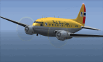
This is a repaint of the C-46 in Fred Olsen Lines 1970 colors. The freeware C-46 by Libardo Guzman and Tom Gibson is needed for this repaint. The famous Norwegian shipping magnate; Fred Olsen, formed his new airline "Fred Olsen’s Flyselskap" in June 1946. It was a nonscheduled carrier, which offered aircraft leasing, passenger and cargo charters, calibration flights, and contract service flights. They started with DC-3s and in 1958 five C-46s joined the fleet. Also, many of the company’s services were undertaken under contract to SAS, the national carrier of the Scandinavian countries. Fred Olsen Lines was focused mainly on cargo flights, and in 1965 their fleet had three C-46s and one DC-6A/B. Two more DC-6s were added to the fleet during 1966-67, followed by a Convair CV-340 in 1968. In 1969 Fred Olsen Lines' emphasis was to offer executive passenger charter services with their new Falcon executive jets. However, this special service did not work for the company, and in 1972 Olsen sold the two Falcons to the Royal Norwegian Air Force. So, the focus was back to Cargo, and in 1974 The first of many L-188Cs joined the fleet. The 1970s and 1980s were quite good for the ailrine and by 1986 the emphasis was shifted entirely to cargo charters. In 1997 Fred Olsen's airline ceased operations.The reasons offered were the loss of maintenance contracts, and difficulties in making a profit in the Central European freight market. This repaint is of C-46 LN-FOR, one of three C-46s operated by Fred Olsen. This repaint was tested on FSX-SE. Textures are 32bit bmp. It should work on FSX, P3D v1-3, & FS2004.
| Filename: | FS2004FSXP3D_Fred_Olsen_C46_1970.zip |
| License: | Freeware |
| Added: | 22nd July 2019, 16:40:12 |
| Downloads: | 104 |
| Author: | Ted Giana |
| Size: | 4.41 MB |
| Category: Flight Simulator 2004 - Aircraft Repaints, Textures and Modifications | |
| Zambia Airways DHC-2 Beaver c1966 |
|
Images related to this file:
File Description:
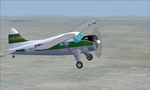
This is a repaint of a DHC-2 Beaver in Zambia Airways colors. The freeware DHC-2 Beaver (wheels) by John L. Woodward is needed for this repaint. It is an FS2004 plane, but I flew it in FSX-SE using the default Beaver panel. The plane can be downloaded here on Avsim, file name: beaver_wheels_2005.zip. Zambia Airways was formed as a subsidiary of Central African Airways (CAA) in April 1964. When CAA collapsed in 1967, Zambia Airways became a fully Zambian owned carrier. In 1968, the fleet consisted of DHC2 Beavers, DC-3s, and two newly delivered BAC-111s from the defunct CAA. They flew on regional routes to Kenya, Malawi, Tanzania, and Mauritius. Alitalia was also hired to provide support of the initiation of new international services. A Douglas DC-8-43 leased from Alitalia was used for the long-haul Lusaka to London flights, which were inaugurated in November 1968, via Nairobi and Rome. In 1970 Zambia Airways took delivery of 3 HS-748s, and in 1974 they received their first Boeing liner; the 707-343C. One year later the two BAC-111s were sold to Dan-Air. July 1976 saw the delivery of the carrier's first 737-200. Zambia Airways received their first wide-body DC-10-30 in July 1984. Zambia Airways did well financially over the years, but by the end of the 1980s and early 1990s, things were a bit more complicated. With financial difficulties facing Zambia Airways, it was forced into liquidation in December 1994. Zambia Airways operated a total of 4 DHC-2 Beavers on local services. This aircraft, 9J-RFZ, was with the airline from 1964 to 1967. This repaint should work on FSX & FS2004. Textures are 32bit BMP.
| Filename: | Zambia_Airways_DHC2_Beaver_c1966.zip |
| License: | Freeware |
| Added: | 22nd August 2019, 08:34:05 |
| Downloads: | 82 |
| Author: | Ted Giana |
| Size: | 2.48 MB |
| Category: Flight Simulator 2004 - Scenery | |
| Grande Prairie CYQU in Alberta, Canada, Updated |
|
Images related to this file:
File Description:
This is a new version of the original post from March 2014, made in 2018. It was made mainly to provide some missing textures, but has been modified to also add parked trucks and floodlights to the de-icing area (the floodlights are inoperative as they will not be on when there is no de-icing in progress) and also street and car parking lighting, a few more parked planes, and some further objects on the terminal apron area. The runway approach lighting was also corrected; moving the airport so that the ILS on 29 did not coincide with the roads would have been nice, but meant too many complications at this stage. The scenery is complete in itself and can be installed as-is if you do not have the original post. Grande Prairie is at 2,195 feet asl, 65 miles southeast of Dawsons Creek, 90 miles southwest of Peace River and around 60 miles east of the Rockies. The town has a population of around 55,000 and growing. The name comes from the wide expanse of prairies all around the town, and there is also a large forested area to the southwest leading up to the Rockies which supplies raw material for industries in the town. The airport is just to the west of the town. It was originally a military base, built during WW2. The two runways are 07-25 and 11-29 and 6,200 and 6,500 feet respectively, both 200 feet wide; runway headings had changed by 2010 in real life but take this as it was in 2008. When one is the active runway then the other is used as a taxiway. Taxiway A is very wide with in real life a repaired central section marked out for use.
| Filename: | Grande_Prairie_CYQU_in_Alberta_Canada_Updated.zip |
| License: | Freeware, limited distribution |
| Added: | 13th December 2018, 04:12:11 |
| Downloads: | 208 |
| Author: | Roger Wensley |
| Size: | 34.97 MB |


© 2001-2026 AVSIM Online
All Rights Reserved
Privacy Policy |