
Where Flight Simulation Enthusiasts Gather from Around the World!
AVSIM Library - Search Results

| Category: Flight Simulator X - Scenery | |
| KDAY - Dayton International Airport - Vandalia, Ohio |

|
Images related to this file:
File Description:
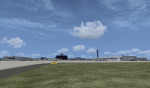
The Dayton International Airport, located 11 miles north of Dayton in Vandalia, Ohio, is a medium sized commercial airport serving nearly three million passengers annually with daily nonstop service to about twenty destinations.
This scenery includes a custom terminal building, moving jetways, and an AFX file with accurate parking assignments. Also modeled is the new air traffic control tower, terminal parking garage, the Fed Ex building, the PSA Airlines headquarters and maintenance hanger, the former Emery Worldwide cargo sort facility, the airport hotel, and hangers for fixed base operators Stevens Aviation and Wright Brothers Aero.
More than a thousand objects have been added to enhance detail around the airport using Flight 1's excellent instant scenery program. AI Traffic has been tested to ensure efficient flow. The landclass file has also been adjusted to better reflect the real airport.
| Filename: | KDAY__Dayton_International_Airport__Vandalia_Ohio.zip |
| License: | Freeware |
| Added: | 2nd December 2012, 22:32:37 |
| Downloads: | 1,568 |
| Author: | Matt Parr |
| Size: | 5.78 MB |
| Category: Flight Simulator 2004 - Scenery | |
| Killaloe CYXI near the Ottawa River in Ontario Canada |
|
File Description:
Killaloe is an old military airfield built for jet fighters in the 1950's,and now officially abandoned. It is 12 miles north of Madawaska Valley Airpark and just to the west of Round Lake, and there is no trouble spotting it as even from 20,000 feet (see the pic) it is very visible. This is mainly because it has a single 6,600 feet runway 29/11, which is likely to be useful if it all goes quiet and you need to land! So it is worth knowing about, even though the asphalt is not in a very good condition. It also continues to be used by the odd passing pilot who cannot resist adding another destination to his log book, though I have no personal knowledge of that. I understand local residents also use it for occasional drag racing, presumably unofficially.
| Filename: | Killaloe_CYXI_near_the_Ottawa_River_in_Ontario_Can.zip |
| License: | Freeware |
| Added: | 27th May 2008, 19:37:07 |
| Downloads: | 423 |
| Author: | Roger Wensley & Jim Turner |
| Size: | 593.04 KB |
| Category: Flight Simulator 2004 - Scenery | |
| Matheson Point CWMP in Nunavut, Canada |
|
Images related to this file:
File Description:
This was a DEW line I Station on the southeast shore of King William Island; the island is around 70 miles square and Gjoa Haven is also on the southeast corner, 20 miles to the south. The station was closed in 1963 and has now been totally dismantled and removed except for a fallen 300 feet communications tower. The runway is still there (mostly) and is around 3,360 feet of gravel 120' wide, aligned 146T/326T. There are no lights, signage, or windsock, or any building remaining. All of these DEW line stations are not particularly impressive or even interesting. However, you can bet that any pilot flying regularly in the north along the coast knows where all these runways are, in case one of them suddenly becomes his favourite in the whole world just after the sudden silence.
| Filename: | Matheson_Point_CWMP_in_Nunavut_Canada.zip |
| License: | Freeware, limited distribution |
| Added: | 22nd November 2012, 16:28:19 |
| Downloads: | 179 |
| Author: | Roger Wensley |
| Size: | 785.57 KB |
| Category: Flight Simulator X - Scenery | |
| TNCC |
|
File Description:
Hato International Airport or Curacao International Airport (originally named Dr. Albert Plesman International Airport) (IATA: CUR, ICAO: TNCC) is the airport of Willemstad, Curacao. It has services to the Caribbean region, South America, North America and Europe. Hato Airport is a fairly large facility, with the third longest commercial runway in the Caribbean region (after Rafael Hern�¡ndez Airport and Pointe-a-Pitre International Airport). The airport was the hub of Air ALM and its successor Dutch Caribbean Airlines, the flag carriers of the former Netherlands Antilles until the latter ceased operations in 2004. The airport is now the home base of Dutch Antilles Express and Insel Air.
This file has the right coordinates, with the apron and characteristics of the airport, working jetways. The runways and runways were resized the gates placed on correct location.
| Filename: | TNCC.zip |
| License: | Freeware |
| Added: | 9th April 2011, 23:52:03 |
| Downloads: | 2,412 |
| Author: | Anwar Gonzalez |
| Size: | 22.3 KB |
| Category: X-Plane - Original Aircraft | |
| Su-34 (Su-27IB) Fighter Bomber |
|
File Description:
The Su-34 (also known as Su-27IB) fighter bomber has been developed by the Sukhoi Design Bureau Joint Stock Company in Moscow and the Novosibirsk Aircraft Production Association at Novosibirsk in Russia. First deliveries of the fighter bomber are expected to begin in 2005 and it is planned as a replacement for Su-24 and Su-25 aircraft. Su-34 is one of a number of Russian aircraft (Su-27, Su-30, Su-33 and Su-35) which have been given the NATO codename Flanker. The Su-34 fighter bomber is a derivative of the Su-27 fighter aircraft. The aircraft design retains the basic layout and construction of the Su-27 airframe, with a conventional high-wing configuration and a substantial part of the onboard equipment. The Su-34 has a changed contour of the nose section to accommodate an advanced multi-mode phased array radar with terrain following and terrain avoidance modes. It has a two-seat rather than single-seat cockpit. The capacity of the internal fuel tanks has been increased with a resulting increased take-off weight. Changes have been made to the central tail boom for a rear-facing radar. This model of the Su-34 for X-Plane version 6.30 includes two air-to-air missile types, the R-27, and R-73. Once downloaded, install the missiles into your weapons folder.
| Filename: | Su34_Su27IB_Fighter_Bomber.zip |
| License: | Freeware |
| Added: | 6th November 2002, 01:21:55 |
| Downloads: | 1,018 |
| Author: | Barry Leger |
| Size: | 2.1 MB |
| Category: Flight Simulator 2002 - Scenery | |
| Nam Phong Royal Thai Air Force Base (Scenery Upgrade) |
|
File Description:
A model of Nam Phong RTAFB as it appeared in mid-1972 when much of it was still under construction. Nam Phong was originally an obscure Thai Air Force training facility located about 60 miles south-southeast of the large USAF/Air America base at Udorn. In response to increasing NVA attacks in the Central Highlands of South Vietnam, the US Marine Corps transferred three fighter/attack squadrons (known as "Task Force Delta")from Da Nang to Nam Phong. A new 10,000 ft. concrete runway was built, and roads, aircraft parking and housing/storage areas were hacked out of the jungle by a joint USN/USMC engineering team. Nam Phong was nicknamed "The Rose Garden" in jest due to the extremely primitive conditions that existed there when the Marines first arrived. The nickname was borrowed from the Marine Corps advertising slogan, "We don't promise you a rose garden", which in turn was inspired by the lyrics of a popular country & western song by Lynn Anderson. The three USMC fighter/attack squadrons that took up permanent residence at Nam Phong were the VMFA-115 "Silver Eagles", the VMFA-232 "Red Devils", and the VMA(AW)-533 "Nighthawks." This enhanced model supercedes the Nam Phong scenery that was uploaded three years ago. It should be compatible with FS 2004. Requires the trees_v3.zip object library by Gerrish Gray.
| Filename: | Nam_Phong_Royal_Thai_Air_Force_Base_Scenery_Upgrad.zip |
| License: | Freeware |
| Added: | 29th January 2006, 23:52:08 |
| Downloads: | 319 |
| Author: | George Knowles |
| Size: | 959.86 KB |
| Category: Flight Simulator X - Scenery | |
| Polish Airports VOL. 2 X DEMO |
|
Images related to this file:
File Description:
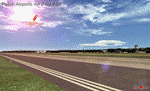
POLISH AIRPORTS VOL. 2 X DEMO is a package of detailed sceneries of EPSC Szczecin, EPLL Lodz and EPZG Zielona Gora airports in Poland, fully compatible with FSX, P3Dv1, P3Dv2 (till v2.1).
This product is a fully functional DEMO version of the commercial payware product. It features same airports layout as in the full version but with limited 3D objects and low resolution textures. Using this free demo ensures no problems with online (VATSIM, IVAO, multiplayer etc.) flying in case some users use the payware scenery and some don't.
Szczecin-Goleniow "Solidarnosc" (SZZ/EPSC) is the main domestic and international airport serving the city of Szczecin in Poland. Lodz Wladyslaw Reymont (LCJ/EPLL), formerly known as Lodz-Lublinek Airport, is a regional airport in central Poland. Zielona Gora-Babimost (IEG/EPZG) is a regional post-military airport located within the greater Zielona Gora agglomeration and is the 11th busiest airport in Poland.
The product is equipped with an automatic installer, which means that the scenery will be automatically added to the Flight Simulator Scenery Library. Please uninstall all previous versions of this airport you may have installed before. Please make also sure that no duplicate AFCAD files are installed.
Enjoy your virtual flying with Drzewiecki Design!
| Filename: | Polish_Airports_VOL_2_X_DEMO.zip |
| License: | Commercial demo |
| Added: | 2nd September 2015, 22:20:07 |
| Downloads: | 676 |
| Author: | Drzewiecki Design |
| Size: | 17.1 MB |
| Category: Flight Simulator X - Scenery | |
| FSX An Idaho Mountain Flying adventure |
|
Images related to this file:
File Description:

Welcome to the Heart of Idaho!
The mountain country has to be seen to be believed. As one who grew up exploring
this part of the US I had the fortunate opportunity to do things that most just dream about. Who wouldn't want to
swim in hot-spring fed lakes, or pools? Idaho has more hot springs than any other state. Have you ever climbed up
to a pass at 10,000 feet? And then looked down at those who chose not to climb 1500 feet below, looked left at your
brother, and then looked over the pass at the mountain basin that begged to be explored. I did these things 58 years
ago. You can do it tomorrow if you want to.
This FSX adventure will take you to many places I have visited. It will also take you to places that I have not yet
visited. Some of the strips are difficult to get into. That is typical of mountain flying. Some are reasonable.
Your flying skills will be tested as you figure out the best approach.
The simulation consists of 19 airports in Central Idaho. Twelve existing strips have had improvements consisting of
strip surface improvements to allow all-season activity, and some eye candy. Seven new air facilities have been
added to the area.
| Filename: | FSX_An_Idaho_Mountain_Flying_adventure.zip |
| License: | Freeware, limited distribution |
| Added: | 29th January 2019, 18:38:19 |
| Downloads: | 189 |
| Author: | Brett Delana |
| Size: | 3.94 MB |
| Category: Flight Simulator 2004 - Aircraft Repaints, Textures and Modifications | |
| Aerial Transit DC-6A / C-118A |
|
Images related to this file:
File Description:
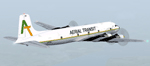
Textures for Tom Gibson's Douglas DC-6A - repainted by Manfred Meyer.
You need to download and install the latest Douglas DC-6A CB-16 base pack with model(use the model with Propspinners), sound and panel from the website calclassic.com.
These textures depict N96BL (c/n 43574) of Aerial Transit. Harold Bellomy and Charles Lawson founded 1963 the Bellomy & Lawson Company in Miami FL, buying DC-6 aircrafts an convert them to pure freighters. They run Challenge Air Transport and sold this airline 1982. Then they started 1983 a part 121 operation under the trading name "Aerial Transit" and ceased operations in 1991. The DC-6 aircrafts of aerial Transit, flying throughout the Caribbean and Central America and were often leased out to other operators of the region. N96BL was built 1952 as C-118A and delivered to the USAF as 51-3827. In 1976 bought by Bellomy & Lawson and registered as N3492F the aircraft served with Challenge AT and re-registered as N96BL from october 1983 until 1991 with Aerial Transit. Aerial Transits DC-6 always looking a little bit shabby and when flying this aircraft, keep in mind it has no pressurisation and no superchargers. So if you are forced to go above 10 000 ft take some oxygen bottles with you!
| Filename: | Aerial_Transit_DC6A__C118A.zip |
| License: | Freeware |
| Added: | 11th October 2014, 20:28:43 |
| Downloads: | 266 |
| Author: | Manfred Meyer |
| Size: | 4.23 MB |
| Category: Flight Simulator 2004 - Scenery | |
| Mackenzie CYZY in British Columbia, Canada |
|
Images related to this file:
File Description:
Mackenzie is around 120 miles west of Peace River and the BC/Alberta border, at the southern end of Williston Lake. The lake is 135 miles long and the population of the town is about 3,500; those figures illustrate typical Canada, a huge area enjoyed by the few. The main occupations relate to timber and mining in some form, plus tourism (in particular winter sports tourism). The airport is 2 miles southwest of the town, with no regular scheduled flights but it is not unusual to find Central Mountain Air there delivering either charter passengers or freight. The single runway is aligned 16-34 and 100 feet wide lit asphalt that is just over 5,000 feet long, with (in 2010 or so) an additional 1,500 feet of gravel. There is PAPI at both ends of the asphalt. The largest operation based at the airfield is a helicopter company, at the northern end of the apron. There is a "mandatory frequency" of 123.5 which is a Canadian invention; you MUST have a radio. There is no control tower at the actual airfield, and if or when there is no response from further afield then you announce your intentions etc. In FS9 there is no way to "switch off or on" the monitoring of a MF radio frequency so you will find that this one is always silent.
| Filename: | Mackenzie_CYZY_in_British_Columbia_Canada.zip |
| License: | Freeware, limited distribution |
| Added: | 27th December 2018, 20:19:05 |
| Downloads: | 133 |
| Author: | Roger Wensley |
| Size: | 19.81 MB |


© 2001-2026 AVSIM Online
All Rights Reserved
Privacy Policy |