
Where Flight Simulation Enthusiasts Gather from Around the World!
AVSIM Library - Search Results

| Category: Orbiter - Miscellaneous Files | |
| Edwards AFB Upgrade 1.1 |

|
File Description:
This upgrade replaces Edwards Air Force Base upgrade 1.0. This is an upgrade to, and requires, Slat's Edwards AFB add-on.
Included in this release:
• Five new high-definition surface tiles (for a total of eleven!), covering the area around Rogers Dry Lake, the main base and the north and south bases, including the town of Boron, CA.
• Edwards AFB ILS and VOR frequencies
• Several main flightline hangars
• Edwards tower camera view
• Mesh resolution increased 800%!
• Scenarios to fly several previously-released X-planes at Edwards AFB
• Support for X-33 VentureStar; placement of the VentureStar base in the correct place, just north of Haystack Butte.
Scenarios are included for the following aircraft, all tested/flown at the real Edwards AFB:
• X-15 rocketplane and B-52 dropship
• SR-71 "Blackbird"
• SR-71 with drone
• X-34 lifting body and Lockheed L-1011 Stargazer dropship
• X-36 thrust vector prototype
• X-38 Crew Recovery Vehicle
• X-33 VentureStar
• Shuttle Training Aircraft
(STA control surfaces patch)
• Space Shuttle Enterprise
| Filename: | Edwards_AFB_Upgrade_11.zip |
| License: | Freeware |
| Added: | 18th November 2003, 16:32:31 |
| Downloads: | 4,492 |
| Author: | John Wilson |
| Size: | 2.81 MB |
| Category: Flight Simulator X - AFCAD Files | |
| KEGE - Eagle County Regional - Eagle, Colorado USA * FIX * |
|
File Description: KEGE - Eagle County Rgnl - Eagle, CO, USA version 1.1 by Jason Boche
This is an update of the default FSX KEGE airport.
Enhancements include:
-Runway 7/25 lengthened to current, displaced threshold and markings added
-Blast pads added
-Updated taxiways to current
-PAPI lights moved to right/north side of runway 25
-Updated LOC frequency for runway 25 to 109.75
-Moved and added additional LOC antennea to the west end of runway 7
-Tower moved and model replaced
-Realistic terminal parking spots 1-10
-Asphalt and concrete aprons added/updated, ground lighting updated
-Asphalt, concrete, and gravel roads added
-Many bulidings updated
-All applicable runway signs updated
-Added airport, civilian, and construction vehicles
-Airport perimeter fencing updated
-Runway demolition fencing added
-National Guard helipads added
-GA refueling moved to the north end of the field
Please provide any feedback and suggestions to me at the email address listed
in the readme.txt. Thank you.
Acknowledgements:
Airport Design Editor (ADE -Freeware) - Jon Masterson.........http://www.scruffyduck.org.uk/
This also has a download centre for many other ADE files.
Please visit here for more information...........http://www.airportdesigneditor.co.uk
Any questions relating to ADE can be answered at www.fsdeveloper.com/forum......look
for Airport Design Editor author
Ray Smith for providing so many freeware airports and airport updates which
inspired me to give ADE a try.
Jason Boche
| Filename: | KEGE__Eagle_County_Regional__Eagle_Colorado_USA__F.zip |
| License: | Freeware |
| Added: | 30th November 2013, 10:42:48 |
| Downloads: | 1,476 |
| Author: | Jason Boche |
| Size: | 373.01 KB |
| Category: Flight Simulator 2004 - Scenery | |
| Bethel: St Mary's area airfields in southwest Alaska close to the Yukon River |
|
Images related to this file:
File Description:
This presumes you have already installed Bethel PABE and Bethel Local Airfields. In the Yukon River area of Alaska to the north of Bethel there are small villages, served by flights from both Bethel and the nearer St Mary's PASM. St Mary's has a gravel runway like the other villages, but has a larger population and airport services including maintenance and fuel. This, plus the saving of an average one hundred miles of flying by a Cessna 205 when compared with flights from Bethel, means it acts as a distribution centre fed from Bethel by larger aircraft. Go to "http://vfrmap.com/" for free vfr maps of the area (see the attached). The ten village airfields included here are all to the north and west of St Mary's: Hooper Bay PAHP, Chevak VAK, Cape Romanzof PACZ (closed air force field servicing a radar station), Scammon Bay SCM, Sheldon Point SXP, Alakanuk AUK, Emmonak PAEM, Kotlik 2A9, Mountain Village MOU, and of course St Mary's PASM itself. With these airfields not everything is as it appears to be. For instance, Hooper Bay is not a new and modernised airfield, despite the asphalt runway and apron; the current version has dispensed with the aging asphalt and gone back to gravel. I have tended to go for the 2005 or so versions, which sometimes means a small runway amid or close to the housing; Kotlik was an early renewal for reasons of safety as much as anything else and has had (since 2003?) a new and longer runway located outside of the town. The second batch of airfields will be to the east of St Mary's.
| Filename: | Bethel_St_Marys_area_airfields_in_southwest_Alaska.zip |
| License: | Freeware, limited distribution |
| Added: | 29th April 2019, 17:07:24 |
| Downloads: | 226 |
| Author: | Roger Wensley |
| Size: | 11.53 MB |
| Category: Flight Simulator 2004 - Scenery | |
| Invermere CAA8 in British Columbia, Canada |
|
Images related to this file:
File Description:
This airfield is in the Columbia Mountains (which are part of the Rockies) on the border between BC and Alberta. Invermere is in the same valley as Golden, 65 miles south and midway between Golden and Cranbrook. The town is at the northern end of Lake Windermere, on the western side, with a population of around 3,400. The main touristic feature of Invermere appears to be the provision of a wide choice of golf courses. These are included in the scenery, as are some of the surrounding commercial buildings including a nearby hotel and retail units. Invermere CAA8 is half a mile northeast of the lake, and is home to the non-profit Canadian Rockies Soaring Club that trains pilots during the summer months. The Invermere Soaring Centre, a separate organisation, provides glider towing services and rides for the general public. During the summer the airfield can only be described as busy, with gliders taking advantage of the terrain for ridge soaring. The AI here includes gliders that will take off and then circle around north of the field. The take off is not a realistic glider style launch, and the wind should be from the north; these gliders do not taxi and then turn around at the far end of a runway too well. Once again, like Golden, there is no runway or taxiway lighting, so daylight use only. There are GA visitors to CAA8 between the gliders, presumably carrying golfers and clubs. Due to the surrounding terrain AI aircraft might impact high ground before landing and then just show up on their parking spot.
| Filename: | Invermere_CAA8_in_British_Columbia_Canada.zip |
| License: | Freeware, limited distribution |
| Added: | 16th October 2018, 02:11:34 |
| Downloads: | 168 |
| Author: | Roger Wensley |
| Size: | 6.11 MB |
| Category: Flight Simulator X - Scenery | |
| RAF Spanhoe - Northamptonshire, England |
|
File Description:
RAF Spanhoe (also known as Harringworth or Wakerley) (ICAO X3SE) is a former World War II airfield in Northamptonshire, England. The airfield is located approximately 4 miles (6.4 km) east of Uppingham; about 80 miles (130 km) north-northwest of London
Opened in 1943, it was used by both the Royal Air Force and United States Army Air Forces. During the war it was used primarily as a transport airfield,
it was closed in late 1945 after the WWII.
Today, much of the airfield has been returned to agriculture, however; the remains of some of the runways can be seen from the air and a part of the old peri track is used by various privately owned light aircraft which are housed at the old airfield. Source: Wikipedia
| Filename: | RAF_Spanhoe__Northamptonshire_England.zip |
| License: | Freeware |
| Added: | 7th March 2016, 21:40:28 |
| Downloads: | 222 |
| Author: | Terry Boissel |
| Size: | 2.36 MB |
| Category: Flight Simulator X - Aircraft Repaints, Textures and Modifications | |
| "US Navy SNJ-4" AT-6 (N7090C) |
|
Images related to this file:
File Description:
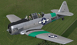
This is a repaint for the payware A2A Simulations AT-6 Texan. This repaint depicts the restored SNJ-4 N7090C, owned by John Bormes and based at Flying Cloud airport, just outside Minneapolis, MN. John Bormes is a member of the T-6 Thunder North American Flight Team, which perform formations of multiple T-6's, at airshows, military dedications, and other events. This particular aircraft, SNJ-4 BuNo.27754, has been on the US civil register as N7090C since the late 1950's, after being stricken from the USN. The current markings are a modified continuation from its 1970's/80's paint scheme as a post-WWII NAS Corry based SNJ, hence the green stripes - the number "370" on the cowl comes from the aircraft's NAA construction number 88-13370.
| Filename: | US_Navy_SNJ4_AT6_N7090C.zip |
| License: | Freeware |
| Added: | 9th May 2016, 17:40:56 |
| Downloads: | 164 |
| Author: | John Terrell |
| Size: | 36.07 MB |
| Category: Flight Simulator X - Scenery | |
| RAF Kelstern - Lincolnshire, England |
|
File Description:
RAF Kelstern is a former Royal Air Force station located 3.6 miles (5.8 km) south east of Binbrook, Lincolnshire and 4.9 miles (7.9 km) north west of Louth,
Opening for business in late September of 1943 the first Sqn to be based at the station was actually formed there (No 625) and became operational in mid October 1943 and was undertaking their first operational tour with 9 Lancasters bombing Hanover afew nights later. As with many RAF Stations, of the era, RAF Kelstern was placed on care and maintenance and finally closed in August 1946. The Station was sold off to various farmers during the 60s with very little left to show of an active airfield. Third party add-on's will be required. See the readme.txt file for details.
| Filename: | RAF_Kelstern__Lincolnshire_England.zip |
| License: | Freeware |
| Added: | 31st October 2015, 12:25:45 |
| Downloads: | 151 |
| Author: | Terry Boissel |
| Size: | 9.63 KB |
| Category: X-Plane - Scenery | |
| BR PE SIFC - Coroa do Aviao Airfield v1.0.0 |
|
Images related to this file:
File Description:

This is an X-Plane 11 and X-Plane 10 scenery package for Coroa do Aviao Airfield (ICAO: SIFC, no IATA), which is a private airport for general aviation located in Iguarassu, Pernambuco, Brazil, north of Recife International Airport (SBRF). It includes corrected aprons, ramps, gates, taxiways, lighting system, city buildings (for Igarassu), ortho-photoscenery for the airfield area, and (XP11 only) airport ground services (like push back). This scenery was tested and is operational (as of June 24, 2017) in "X-Plane 11.02r1 64 bit", Windows 10 Home. It was also tested and is also operational (as of June 24, 2017) in "X-Plane 10.51 64 bit", Windows 10 Home. Only the default X-Plane 11 libraries, by Laminar Research, are needed. No third party libraries are used.
| Filename: | BR_PE_SIFC__Coroa_do_Aviao_Airfield_v100.zip |
| License: | Freeware |
| Added: | 25th June 2017, 22:24:37 |
| Downloads: | 68 |
| Author: | Rui Mesquita |
| Size: | 8.64 MB |
| Category: X-Plane - Scenery | |
| BR GO SWWA - Porangatu Airport v1.0.0 |
|
Images related to this file:
File Description:
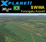
This is an X-Plane 11 and X-Plane 10 scenery package for Porangatu Airport (ICAO: SWWA, no IATA), which is the airport serving the city of Porangatu, Goiás, Brasil. It includes corrected aprons, ramps, gates, taxiways, lighting system, city buildings, ortho-photoscenery for the airfield area, and (XP11 only) airport ground services (like push back). This is a small general aviation airport, in north up state of Goais, in Brazil. This scenery was tested and is operational (as of January 03, 2018) in "X-Plane 11.11 64 bit", Windows 10 Home. It was also tested and is also operational (as of January 03, 2018) in "X-Plane 10.51 64 bit", Windows 10 Home. Only the default X-Plane 11 libraries, by Laminar Research, are needed. No third party libraries are used.
| Filename: | BR_GO_SWWA__Porangatu_Airport_v100.zip |
| License: | Freeware |
| Added: | 3rd January 2018, 18:19:13 |
| Downloads: | 54 |
| Author: | Rui Mesquita |
| Size: | 7.71 MB |
| Category: X-Plane - Scenery | |
| BR PB SNTS - Patos Airport v1.0.0 |
|
Images related to this file:
File Description:

This is an X-Plane 11 and X-Plane 10 scenery package for Brigadeiro Firmino Ayres Airport (ICAO: SNTS, no IATA code), whici is the airport serving Patos, ParaÃba, in Brazil.
It includes corrected aprons, ramps, gates, taxiways, lighting system, city buildings, ortho-photoscenery for the airfield area, and (XP11 only) airport ground services (like push back).
The airport is located 12 km from the city center and 30 km north from Rio Grande do Norte (same distance south of Pernambuco). The city of Patos is strategically located to house an airport.
This scenery was tested and is operational (as of January 17, 2018) in "X-Plane 11.11 64 bit", Windows 10 Home. It was also tested and is also operational (as of January 17, 2018) in "X-Plane 10.51 64 bit", Windows 10 Home.
| Filename: | BR_PB_SNTS__Patos_Airport_v100.zip |
| License: | Freeware |
| Added: | 2nd February 2018, 00:13:22 |
| Downloads: | 49 |
| Author: | Rui Mesquita |
| Size: | 8.36 MB |


© 2001-2026 AVSIM Online
All Rights Reserved
Privacy Policy |