
Where Flight Simulation Enthusiasts Gather from Around the World!
AVSIM Library - Search Results

| Category: Flight Simulator X - Panels | |
| FSX Glass Cockpit Mini Panel |

|
Images related to this file:
File Description:
FSX Glass Cockpit Mini Panel that many of you requested is intended to replace the global default minipanel or my previous analog mini panel. The mini panel is made up of freeware Glass Cockpit LCD instruments. This gives the pilot a common set of LCD gauges to use on multiple aircraft. Many pop-up windows available to keep the main mini panel uncluttered. Additional navigation and control surfaces gauges are provided. Information is provided for wind direction, drift, ETA, ETE, direction, distance and name of the nearest airport; direction and distance to the next waypoint set in the GPS; and radar/absolute altitude. Karol Chlebowski�s TFR gauge is included that allow flight at extremely low altitudes. Also included is Dietmar Loleit new TCAS gauge for FSX. Extensive tooltips have been provided on most gauges.
| Filename: | FSX_Glass_Cockpit_Mini_Panel.zip |
| License: | Freeware |
| Added: | 21st September 2010, 21:39:33 |
| Downloads: | 1,221 |
| Author: | Bill McClellan |
| Size: | 4.61 MB |
| Category: Flight Simulator 2004 - Panels | |
| FS2004 Glass Cockpit Mini Panel |
|
Images related to this file:
File Description:
FS2004 Glass Cockpit Mini Panel that many of you requested is intended to replace the global default minipanel or my previous analog mini panel. The mini panel is made up of mostly Glass Cockpit LCD instruments. This gives the pilot a common set of LCD type gauges to use on multiple aircraft. Many pop-up windows available to keep the main mini panel uncluttered. Additional navigation and control surfaces gauges are provided. Information is provided for wind direction, drift, ETA, ETE, direction, distance and information on the nearest airport; direction and distance to the next waypoint set in the GPS; and radar/absolute altitude. Lee Hetherington excellent TCAS gauge is also available. Karol Chlebowski�s TFR gauge is included that allow flight at extremely low altitudes. Extensive tooltips have been provided on most gauges.
| Filename: | FS2004_Glass_Cockpit_Mini_Panel.zip |
| License: | Freeware |
| Added: | 21st September 2010, 21:40:15 |
| Downloads: | 685 |
| Author: | Bill McClellan |
| Size: | 5.17 MB |
| Category: Flight Simulator 2004 - Panels | |
| F-14B Panel and FDE |
|
File Description:
This package upgrades Dino Cattaneo's F14B model for FS2004.
The panel features Heads Up, Heads Down and RIO views with catapult & arrestor cables control.
Uses a custom FSNavigator interface for IFR, Tactical, and Aircraft Carrier Autoland.
The package Includes Fuel Computer, Apollo GPS, TCAS Radar, TCAS HUD, Meatball HUD, Mini Panel, and GPWS pull-up Warnings. All HUD funtions work togeather with collective intigration.
The F-14B FDE is refit from my previous F-14A FDE that was with Dino Cattaneo's visual model for FS2002.
The new FDE features real world F-14B specifications, editable ordinance weights, and has all specifications listed in the FS09 Kneeboard. The autopilot is updated for fighter models with tighter turns, and minimal overshoot. The FDE also includes the latest effects for the model. Credit is given to many authors who have taken an interest in fighter aircraft.
| Filename: | F14B_Panel_and_FDE.zip |
| License: | Freeware |
| Added: | 16th February 2004, 23:34:10 |
| Downloads: | 6,387 |
| Author: | John J Schumacher |
| Size: | 4.99 MB |
| Category: Flight Simulator 2004 - Scenery | |
| Hall Beach CYUX in Nunavut, Canada |
|
Images related to this file:
File Description:
Hall Beach is on the Melville Peninsula, part of the mainland of Canada, south and west of Baffin Island. It is around 40 miles south of Igloolik and 50 miles west of Rowley, both of them my previous posts. The airfield was built to support the construction and operation of a main DEW line radar station and to support the rest of the associated chain. Because of the employment opportunities this brought, a village developed nearby. The airfield continues in regular use and the runway, though still gravel, is 5,400' long and 150' wide and lighted; the alignment is 124T and 304T as this is in northern domestic airspace and bearings are given as 'true" and not "magnetic". There are scenery folders for the village, roads, grass, etc, and AI for two airlines with regular service to Hall Beach.
| Filename: | Hall_Beach_CYUX_in_Nunavut_Canada.zip |
| License: | Freeware, limited distribution |
| Added: | 22nd November 2011, 14:33:08 |
| Downloads: | 456 |
| Author: | Roger Wensley |
| Size: | 3.83 MB |
| Category: Flight Simulator 2004 - Miscellaneous Files | |
| Active ILS - KDEN |
|
File Description:
As most know initiating the ILS at certain airports for AI Traffic is not a function at this time when using AFCAD2. If you add a new ILS runway to an airport such as KDEN (Denver International Airport 16R/34L) only the user aircraft can use this runway when visibility falls below 3 miles. ATC will no longer use this runway for AI Traffic because FS9 sees it as a visual runway and will now vector your AI Traffic to a FS9 stock ILS runway. This file adds all NAVAIDS for making 16R/34L a Precision Instrument Runway by adding all the radar fixes for both the ILS approach portion and the proper missed approach procedures, altitudes and intersections as per current published plates. All AI Aircraft will now continue to use 16R/34L when Airport conditions are less than 3 miles.
| Filename: | Active_ILS__KDEN.zip |
| License: | Freeware, limited distribution |
| Added: | 17th June 2004, 16:17:08 |
| Downloads: | 1,588 |
| Author: | Jim Vile |
| Size: | 50.28 KB |
| Category: X-Plane - Original Aircraft | |
| USAF F-15E |
|
File Description:
The F-15E is a two-seat, dual-role, totally integrated fighter for all-weather, air-to-air and deep interdiction missions. The rear cockpit is upgraded to include four multi-purpose CRT displays for aircraft systems and weapons management. The digital, triple-redundant Lear Siegler flight control system permits coupled automatic terrain following, enhanced by a ring-laser gyro inertial navigation system. For low-altitude, high-speed penetration and precision attack on tactical targets at night or in adverse weather, the F-15E carries a high-resolution APG-70 radar and low-altitude navigation and targeting infrared for night pods. This model of the F-15E for X-Plane version 6.30 includes the guided weapons shown above as well as drop tanks and electronics pods. Once downloaded, install the missiles, tanks and pods into your weapons folder.
| Filename: | USAF_F15E.zip |
| License: | Freeware |
| Added: | 6th November 2002, 01:21:00 |
| Downloads: | 591 |
| Author: | Barry Leger |
| Size: | 1.38 MB |
| Category: Flight Simulator X - Gauges | |
| Boeing 727-100/200 Various Fixes Ver2.0 |
|
File Description:
NEW for this version: Throttle control via the EPR setting bugs during cruise - Disabling of selected features.
The following are corrections or added enhancements to the Captain Sim B727-100/200/F:
-1 Airspeed Indicator Enhancement
-2 ADI & Flight Director Corrections
-3 A/P Enhancement for Flight Director
-4 Radar Altimeter Fix
-5 TAT Display toggle via DME Indicators
-6 Trim Sensitivity Fix (Optional)
-7 Auto Setting of Altimeter Alert (Optional)
-8 Auto setting of Take-off Elevator Trim (Optional)
-9 GPWS Switch Fixed (Optional)
-10 NAV/GPS toggle via Marker Beacon Sensitivity Switch (Optional)
-11 EPR Bug Setting Knob & Display Fixed
-12 Throttle Control via EPR Bug Setting Knob Fixed (Auto Mode)
-13 Maximum Continuous Thrust (MCT) drives EPR Bugs (Manual Mode)
| Filename: | Boeing_727100200_Various_Fixes_Ver20.zip |
| License: | Freeware, limited distribution |
| Added: | 31st May 2015, 21:04:54 |
| Downloads: | 1,814 |
| Author: | Paul Tally |
| Size: | 5.29 MB |
| Category: Flight Simulator 2004 - Scenery | |
| Alaska North Slope 3: Atqasuk (PATQ) |
|
Images related to this file:
File Description:
The town of Barrow is in the far north of Alaska, and these are coastal villages or radar installations to the west and south of Barrow. There will be further additions. Atqasuk PATQ is 55 miles south of Barrow and is unusual in that it is one of the few settlements of the North Slope that is not on the coast. It is, however, on a narrow winding river that reaches the sea to the east of Barrow and seemingly provides fish in abundance. There could well be other good reasons for the village to be where it is, but they are unknown to me. The population is around 250. The airfield is to the south of the village and the runway is 4,900 feet of gravel aligned 06-24, lit, and with PAPI at each end.
| Filename: | Alaska_North_Slope_3_Atqasuk_PATQ.zip |
| License: | Freeware, limited distribution |
| Added: | 17th June 2016, 08:54:55 |
| Downloads: | 233 |
| Author: | Roger Wensley |
| Size: | 2.35 MB |
| Category: Flight Simulator X - Panels | |
| Boeing 767 |
|
File Description:
FSX Boeing B767 Panel. This comes from an old FS98 panel by Eric Ernst which is one of the best jobs I have seen, even better than many so-called "realistic" panels for later FS releases. Since I greatly missed this panel, then I have reworked it for FSX. All gauges react to panel lights and avionics buses, making it great to flight at night. Also features no-smoking/fasten-seat belts signs, plus tape sliding radar altimeter, regulable seat position and animated yoke. Last but not least, I have included the whole gauges source code under GPL (gauge programmers will love this!). Gauges programmed with an eye towards frame rate. This new version features reworked HSI (arc/rose), reworked autobrake and gauge switches sound. By Alessandro Antonini, author of Super Flight Planner. Older FS2004 version is still available on avsim.com and cpinf.com
| Filename: | Boeing_767.zip |
| License: | Freeware |
| Added: | 9th September 2007, 19:06:47 |
| Downloads: | 19,076 |
| Author: | Alessandro Antonini |
| Size: | 1.02 MB |
| Category: Flight Simulator X - Utilities | |
| Landing Parameters for FSX and P3D |
|
Images related to this file:
File Description:
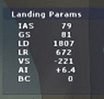
Landing_Params is a Lua script for FSX/P3D that displays landing parameters in a small text window that pops
up after the aircraft has landed and has reached taxi speed. The script should be activated with a key or button (like the gear
down key/button) during the approach to landing. Parameters displayed in the window after touchdown are
Indicated Airspeed (IAS, Kts), Ground Speed (GS, Kts), Landing Distance (LD, ft), Landing Roll (LR, ft), Vertical
Speed (VS, ft/min), Attitude Indicator pitch at touchdown (AI), and Bounce Count (BC). Data collection begins
when the a/c passes through a radar altimeter determined threshold altitude window between 45 and 55 ft
(i.e., the nominal 50ft threshold height). In addition, more detailed landing parameter information may be
logged. A registered copy of FSUIPC is required to execute the Lua script.
| Filename: | Landing_Parameters_for_FSX_and_P3D.zip |
| License: | Freeware |
| Added: | 18th February 2018, 04:09:32 |
| Downloads: | 568 |
| Author: | Al Klayton |
| Size: | 164.08 KB |
© 2001-2026 AVSIM Online
All Rights Reserved
Privacy Policy |