
Where Flight Simulation Enthusiasts Gather from Around the World!
AVSIM Library - Search Results

| Category: Flight Simulator X - Scenery | |
| 2 Fronson Hangars |

|
Images related to this file:
File Description:
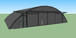
This model was created to be placed in FSX as airport scenery using Airport Design Editor.
I created it for my own use when i was re-creating RNAS HMS Nuthatch which was a Naval Airstation near Anthorn on the Solway Coast in Cumberland (now Cumbria), United Kingdom.
History of RNAS HMS Nuthatch...
Work began on building an airfield at Anthorn for the Fleet Air Arm in late 1943, with Royal Naval Air Station Anthorn, or HMS Nuthatch opening on 7 September 1944, with three tarmac runways.
It was the base of No. 1 Aircraft Receipt and Despatch Unit (No. 1 ARDU), which had the job of receiving aircraft fresh from manufacturers, modifying them to Service standards and despatching them to operational squadrons, with the unit specialising in the Vought F4U Corsair.
No. 1 ARDU continued to operate from Anthorn following the end of the Second World War, while a number of Fleet Air Arm Squadrons were also based at the airfield in the immediate post war years.
The airbase shut down in March 1958.
The Airfield is now the site of a VLF/LF transmitter used for transmitting orders to Submarines, it is also home to three atomic clocks for transmitting Britains time signal transmissions.
None of the Hangars (11 Pentad and 22 Fromson) survive at the site but their concrete standings are still visable.
Depicted here are representations of the Fromson type hangers created from dimensions in a 1947 survey.
I created the model using Google Sketchup and converted it for use in FSX using Model ConverterX.
This is my 1st attempt at scenery creation and is therefore pretty basic.
There are no known issues and it works fine in FSX.
| Filename: | 2_Fronson_Hangars.zip |
| License: | Freeware |
| Added: | 8th June 2014, 07:13:54 |
| Downloads: | 251 |
| Author: | Mark John Byers |
| Size: | 1.4 MB |
| Category: Flight Simulator 2004 - Scenery | |
| CZNL - Nelson - Nelson, British Columbia, Canada |
|
Images related to this file:
File Description:
Nelson is a town with a population of around 10,000, located 250 miles or so east of Vancouver on the southern shore of an east-west offshoot of Kootenay Lake. The surrounding landscape can be described as "steep" without fear of contradiction, and the diagram of arrival and departure routes (included here) shows that straight finals to either end of the runway are non-existant. The airport is right beside the water, with a single runway 3,100 feet long and 75 feet wide, aligned 04/22. The apron is at the western end. There are a number (3?) of helicopter companies based at the western end of the apron, and there is also a terminal building, though there are in fact no regular scheduled flights; there are occasional charters to cater for town events during the summer tourist season. There is no runway lighting, or taxiway or apron lights, so usage is effectively restricted to daylight hours (though not legally stated as such). All circuits are over the water and not the town, though even this means you climb quickly and dog-leg to follow the water until you have gained enough altitude to turn. Winter maintenance is limited. And if all this is not enough you are advised to "watch for wildlife on the rwy". The nature of the surrounding terrain makes AI hit-and-miss; mostly hit. AI Planes will taxi out and then take off, and provided you don't follow them until they fly into a mountain it will all appear normal. Planes that are arriving will appear by magic on their parking spots, as they have crashed before they arrive. To avoid repetitive unrealistic arrivals I have limited the AI to only 3 planes. The scenery includes some of the nearby buidings and landmarks, as shown in the screenshots.
| Filename: | CZNL__Nelson__Nelson_British_Columbia_Canada.zip |
| License: | Freeware, limited distribution |
| Added: | 7th June 2015, 10:23:49 |
| Downloads: | 426 |
| Author: | Roger Wensley |
| Size: | 17.84 MB |
| Category: Flight Simulator 2004 - Scenery | |
| Airstrips of North-West Europe |
|
Images related to this file:
File Description:
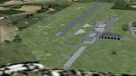
The sales blurb for FS2004 announced the inclusion of over 23,000 airfields ... unfortunately a significant number of those consisted of little or nothing more than a runway on a flatten with a rectangular background polygon.
To enable the addition of an amount of lightweight GA AI traffic, without overloading those airfields that were designed with parking spaces and taxi-ways, (and are probably already busy), I herewith include over 140 small sceneries, of mostly default airfields, from NW France, up the English Channel and the North Sea coast through Belgium, the Netherlands and NW Germany to Denmark, all with added taxiways and parking spots, aprons, generic buildings and background polygons as appropriate, to enable AI traffic to be generated without interrupting things at the more major airports.
A few of the French airfields are "new", not included originally with FS2004, and a couple have been updated to suit more recent developments :- for example, LFES "Scaer Guiscriff" is now LFES "Bretagne Atlantique", LFOR "Chartres Champhol" is now LFOR "Chartres Metropole", EHSE "Seppe" is now EHSE "Breda International" and EKVH "Vesthimmerlands" was previously EKVH "Aars".
There's no photo-realism here, just a selection of basic 'generic' buildings, more or less accurately sized and placed to reflect the airfield layout as seen on on-line satellite imagery and aerial photography. These buildings have minimal effect on frame-rates, so are ideal for this kind of job.
The airfields are aligned as well as possible with the roads etc. in UT Europe and the Genesis Europe mesh, but should mostly be fine in a default installation or other configuration.
Please read the rest of this "waffle" in the included text file ... it might save some confusion ;)
Enjoy :)
| Filename: | Airstrips_of_NorthWest_Europe.zip |
| License: | Freeware |
| Added: | 14th June 2024, 13:44:58 |
| Downloads: | 293 |
| Author: | Chris Eve |
| Size: | 9.95 MB |
| Category: Flight Simulator X - Original Aircraft | |
| Airbus A318 FD Special Version V3 - Light Pack |
|
Images related to this file:
File Description:

This is the new version of my Airbus A318 with the Panel in V3 opened on the A321 - here in a light pack version, included is 1 livery only (Frontier Airlines NR807 Painted by Derek Mayer & Steve Mac Bee of PA Team).
This light pack contains only the user manual in english version (and low resolution). If you want the french version of this manual, use the "zipdrive" function with the complete pack of this aircraft (search by name file "pa318fd_v3.zip"). This light version has been made by request for all those with low download speeds and limits.
The original complete pack is available HERE (filename: pa318fd_v3.zip)
I remind you that this aircraft is based on the Project Airbus A318, with an ehanced panel based on the work of stefan Liebe.
This latest development can see the more realistic Airbus available as freeware. With a new version of the panel, the aircraft has a 100% cold & dark Status at the start of a flight, a real fuel system management with all valves, piumps and crossfeed work, the complete Bleed circuit with X-bleed, a real engines manual startup procedure like the real aircraft. I have also ehanced the navigation display with TCAS function in ARC and NAV mode; There is also the engines failure procedure to work (fire, oil leaks....) and many improved function that I cannot describe here. The aircraft comes with user manual in English and in French, and it is essantial to read it before you fly.
All the functions of the V2 have been kept and improved, like the vertical navigation gauge, the terrain radar map on the navigation display, the autolanding function, the SFCC.
This version is only in CFm engines, but with real engine data (CFM56-5B9) and custom HD sounds. Now, the Fly By wire works in 2 modes: "Normal Law" and "Direct Law". I put 300 hours into the development of this panel and I hope that you will like it.
Please, note that this panel is the v3.05 version, witch fixes the bugs of the first version that came with the A321 (there is an update panel for the A321).
So, It seems that this aircraft works with PREPAR3D
Francois Dore
| Filename: | Airbus_A318_FD_Special_Version_V3__Light_Pack.zip |
| License: | Freeware, limited distribution |
| Added: | 14th July 2012, 15:34:06 |
| Downloads: | 6,735 |
| Author: | Francois Dore, Project Airbus |
| Size: | 64.88 MB |
| Category: Flight Simulator 2004 - Aircraft Repaints, Textures and Modifications | |
| Royal Hellenic Air Force Supermarine Spitfire Collection |
|
File Description:
This package includes all the Hellenic Spitfires expect the Spitfire pr Mk.XI witch appeared in one unit and pr Mk.XIII in three units. You can fly the spitfire mk.Vb/c, Spitfire mk.IXe LF/HF and Spitfire Mk.XVIe LF. Greece in 9/23/1938 ordered 12 Spitfires and 12 Anson. During the June of 1939 it was signed the order of 24 Spitfires which cost 9335 pounds each. When Hitler attacked to Poland, England used all the aircrafts that were under construction and of course the Greek were some of them. On 10/12/1943, the 336th Olympus Squadron received the first Spitfire and followed the 335th Tiger Squadron. The Spitfire mk.Vb/c replaced the Hurricane mk.IIb/c. When the two greek Squadrons were at North Africa, their Spitfires wore the
| Filename: | Royal_Hellenic_Air_Force_Supermarine_Spitfire_Coll.zip |
| License: | Freeware, limited distribution |
| Added: | 2nd December 2005, 19:59:29 |
| Downloads: | 3,887 |
| Author: | Delizisis Thanasis, Delizisis Panagiotis, Ken Harrison (Merlin66) |
| Size: | 19.6 MB |
| Category: Flight Simulator X - Scenery | |
| YPNW Pannawonica, Western Australia town and strip |
|
File Description:
YPNW Pannawonica with FSX default and ORBX tints condensed into one zipfile. The town of Pannawonica is an iron-ore mining town located in the Pilbara region of Western Australia, near the Robe River, about 200��� km south-west from Karratha. In 2006, it reportedly had the highest median weekly income of any town in Australia, due to the high income of its mine workers. Pannawonica was built in 1970 by Cleveland-Cliffs Robe River Iron (predecessor of the present Robe River Iron Associates) and was gazetted as a townsite in 1972. The township�¢����s name was derived from nearby Pannawonica Hill, named by a surveyor in 1885 after the corresponding Aboriginal placename which is said to mean "the hill that came from the sea". The traditional legend is that two local Aboriginal tribes were arguing over the ownership of the hill which was located by the sea. The sea spirit decided to resolve the dispute by moving the hill inland. As the hill was dragged over the land it left a deep indentation which became the Robe River. Pannawonica is one of a number of remote-area iron-ore-mining towns built throughout the Pilbara to house workers operating open-cut mines and the loading of ore trains. It is a 'closed town', having limited facilities for visitors, the company's accommodation being reserved for its staff and visiting contractors. Some visitor accommodation is available at the Pannawonica Tavern. Pannawonica is home to more than 800 people, comprising Robe and Pilbara Iron employee families, staff on fly-in fly-out (�¢����fifo�¢����) roster from Perth, and those involved in support services. It is accessible by road, rail and light aircraft. REQUIRES Blencowe_LibraryKit.zip
REQUIRES blencowe_librarykit_309494.zip (Available HERE)
| Filename: | YPNW_Pannawonica_Western_Australia_town_and_strip.zip |
| License: | Freeware |
| Added: | 28th February 2013, 14:00:44 |
| Downloads: | 287 |
| Author: | Alan Blencowe |
| Size: | 3.38 MB |
| Category: Flight Simulator 2004 - Aircraft Repaints, Textures and Modifications | |
| Italian Air Force "S.M.Luigi Gorrini" AerMacchi C.205 VELTRO (Greyhound) |
|
Images related to this file:
File Description:
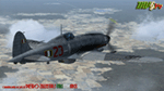
Regarded as the best Italian aircraft of World War II together with the Fiat G-55 Centauro,the Macchi-Castoldi C.205 proved to be extremely effective in action, destroying a large number of Allied bombers and capable of successfully clashing on equal terms with such renowned fighters as the North American P-51D Mustang.Although the C.205 was able to match the best Allied opponents both in speed and maneuverability,it was introduced late during the conflict.Moreover,due to the poor Italian industrial capability of the time,only a small production run was delivered to combat units before the end of the war.Famous C.205 pilots are Italy's highest scoring ace Adriano Visconti and the top scoring C.205 Sergente Maggiore pilota (Sargeant Major pilot) Luigi Gorrini.To date,there's still debate about
Gorrini's score,since Regia Aeronautica preferred crediting units over individual combat achievements.
Gorrini's official aerial combat score is 19 victories,but,according to his memories,he achieved 7 more during his service with Aeronautica Nazionale Repubblicana (A.N.R.), flying a Macchi C.205. These victories did not enter his officiall tally due to political reasons,since the A.N.R. fought by the side of the German Luftwaffe after the Italian September 8th,1943 armistice.These bring his total tally to 26 victories,making him the top scoring Italian fighter ace of WWII.For his combat record with the A.N.R he was awarded twice by the Luftwaffe with the Iron Cross First and Second Class.Luigi Gorrini was also awarded for his actions,after the end of the war,with the highest Italian military decoration,the "Medaglia d'Oro al Valor Militare" (M.O.V.M.,Gold Medal for Military Valour).Last surviving Italian fighter pilot of WWII,he died recently at the age of 97 and this repaint is dedicated to his memory.
Repaint by Manuele Villa/MVG3D, November 2014.
Requires the previous installation of the base Aermacchi C.205 Veltro package by Manuele Villa (C205_V01.zip).
| Filename: | Italian_Air_Force_SMLuigi_Gorrini_AerMacchi_C205_V.zip |
| License: | Freeware |
| Added: | 25th November 2014, 08:39:29 |
| Downloads: | 130 |
| Author: | Manuele Villa |
| Size: | 4.31 MB |
| Category: Flight Simulator 2004 - Scenery | |
| Coal Harbour CAQ3 float base in British Columbia, Canada |
|
Images related to this file:
File Description:
This is number eight in a series of new and renovated float bases in BC. Coal Harbour is in a sheltered cove off Holberg Inlet on the northwest coast of Vancouver Island, close to the village and 10 miles southwest of the Port Hardy float base. There is 100LL fuel and oil available. Due to the deep fjords that run into Vancouver Island from the west coast Coal Harbour is actually closer to the east coast than it is to the west coast. The tortuous route in through Quatsino Sound and Rupert Sound shelters the waters of Holberg Inlet from the stormy seas of the west coast, and fishing boats take advantage of this. The floatplane dock is to the south of the large (and old) hangar, adjacent to the southern end of the fixed dock where the ramp bridge descends to the floating docks. The video makes it clearer. The AI is a further adaptation of the CF36 AI and involves Beavers and Otters as listed in the AI folder. Due to the surrounding hills there may be some interference with AI aircraft, depending on the wind direction, though I have watched succesful Beaver and Otter landings. Amid the hills there is a very large hole in the ground to the east. The village name suggests it may have been for coal but though in fact there was a coal mine, that was a much smaller and unsuccesful venture; this particular scene of enthusiastic digging was for copper, until 1996. The main claim to fame of Coal Harbour was that it was the last whaling station in North America, using the buildings that were part of the RCAF float plane patrol base during WW2. One downloader reported a texture problem with Port McNeill, to which we found a solution. As he was the only person to email me I am going to presume that nobody else had the problem.
| Filename: | Coal_Harbour_CAQ3_float_base_in_British_Columbia_C.zip |
| License: | Freeware, limited distribution |
| Added: | 25th January 2017, 00:29:05 |
| Downloads: | 225 |
| Author: | Roger Wensley |
| Size: | 7.79 MB |
| Category: Flight Simulator 2004 - Scenery | |
| St Michael Island in Alaska-St Michael 5S8 and Stebbins WBB |
|
Images related to this file:
File Description:
St Michael Island is 50 miles southwest of Unalakleet, an island that in fact appears to be a cape and a firmly attached piece of the mainland. On the island there are two villages, St Michael on the northeast corner and Stebbins on the northwest. St Michael has a new airfield that is west of the village by around a mile or so, with a gravel runway 4,000 feet long. The old and now closed airport was known as SMK, and is now readily identifiable by the new red-roofed school building that occupies the centre of the runway. The new airfield now has an icao code of PAMK, but FS9 does not readily accept icao code changes so we are stuck with the original code it was given, 5S8. The SMK icao of the old airport will still show on your gps as if I deleted it the runway would also have to be deleted, and a substitute and unsatisfactory gravel apron made to impersonate a runway. Stebbins is 5 miles west of St Michael and next to the shore, a smaller village than St Michael with around 250 inhabitants. The airfield is at the southern end of the village and has a gravel runway that is 3,000 feet long. The icao code is WBB. There is no AI included here as it was already included in the post of Shaktoolik. There is a correction here for Shaktoolik, which I now find should have had a blue garage, not a red one; I wrongly named a photo. A note here about my scenery making. This is post number 501 and there will not be many more to follow this as I am almost at the end of the photos I took or found for scenery purposes. There is a limit to what can be located online and I have already been making use of the little there is; eg Unalakleet. So, if you are near an airfield (preferably Canadian or Alaskan) and have a camera..... Let me know.
| Filename: | St_Michael_Island_in_AlaskaSt_Michael_5S8_and_Steb.zip |
| License: | Freeware, limited distribution |
| Added: | 1st August 2019, 16:45:58 |
| Downloads: | 96 |
| Author: | Roger Wensley |
| Size: | 3.88 MB |
| Category: Flight Simulator 2004 - Scenery | |
| Koyukuk KYU in Alaska |
|
Images related to this file:
File Description:
Koyukuk is a small village on the northern bank of the Yukon River, around 5 miles east of where the river turns from north-south to east-west, east being upstream towards the distant Fairbanks. The mouth of the Koyukuk River that joins the Yukon is just to the east of the village. The population is now under 100 and living from fishing and the land. During the late 1800's the local population lived off the land and also by the spin off from gold mining in the same way as the nearby Nulato, but when in the early 1900's gold mining activities moved to Nome and Fairbanks local prosperity plunged. In fact, the village only became a permanently inhabited establishment in 1939, when a school was built. The airfield is close by and has a gravel runway aligned 6-24 and 4,000 feet long with PAPI on the approach to 6. There is also a shorter and parallel grass runway that is only used in the winter snows by light planes that are on skis and without wheels. Apart from the airfield itself, and it's buildings, this scenery modifies the local land class, adds village buildings while reducing the village size to reality, and creates a new airfield background. Koyukuk is served by Wright Air from Fairbanks in the east and this is included in the AI provided with the post of Nulato. A note here about my scenery making. This is post number 509 and there will not be many more to follow this as I am almost at the end of the photos I either took or found for scenery purposes. There is a limit to what can be located online and I have already been making use of the little there is; eg Unalakleet. So, if you are near an airport (preferably Canadian or Alaskan) and have a camera..... Let me know.
| Filename: | Koyukuk_KYU_in_Alaska.zip |
| License: | Freeware, limited distribution |
| Added: | 30th August 2019, 18:23:12 |
| Downloads: | 125 |
| Author: | Roger Wensley |
| Size: | 3.26 MB |


© 2001-2026 AVSIM Online
All Rights Reserved
Privacy Policy |