
Where Flight Simulation Enthusiasts Gather from Around the World!
AVSIM Library - Search Results

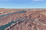
| Category: Flight Simulator 2004 - Scenery | |
| Capitol Reef National Park/South - Waterpocket Fold, Utah, Photo-Scenery |

|
Images related to this file:
File Description:

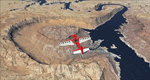
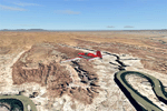
Capitol Reef National Park/South - Waterpocket Fold, Utah, Photo-Scenery (for FS9 & FSX)
This scenery covers the area from the southern part of Capitol Reef National Park down along the Waterpocket Fold and the Henry Mountains. It extends my Canyonlands sceneries to the west and brings you another 3.500 sq km in 4.7m/pix quality. To explore the scenery depart from Hanksville (KHVE) and head northwest. High resolution versions of this scenery for FS9 and FSX (much sharper, but larger and multiple downloads)
are available at www.blueskyscenery.com/CNY_SouthWest2.html . The screenies are taken from the high-res versions, so expect this version to be slightly more blurry. YourDonation@Work: Eric and Andy.
| Filename: | Capitol_Reef_National_ParkSouth__Waterpocket_Fold_.zip |
| License: | Freeware, limited distribution |
| Added: | 13th January 2010, 20:46:53 |
| Downloads: | 1,729 |
| Author: | Gottfried Razek - blueskyscenery.com |
| Size: | 95.92 MB |
| Category: Flight Simulator 2004 - Scenery | |
| Lake Powell - Bullfrog Basin (U07), Utah, Photo-Scenery (FS9 & FSX) |
|
Images related to this file:
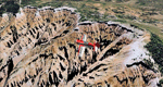
File Description:
This scenery covers the area from the southern end of the Waterpocket Fold down to the Bullfrog Basin and the eastern end of the Kiaparowits Plateau. It extends my Canyonlands sceneries to the southwest and brings you another 3.500 sq km in 4.7m/pix quality. To explore the scenery depart from Bullfrog Basin Airport (U07) and west. High resolution versions of this scenery for FS9 and FSX (much sharper, but larger and multiple downloads)
are available at www.blueskyscenery.com/CNY_South2West2.html . The screenies are taken from the high-res versions, so expect this version to be slightly more blurry. YourDonation@Work: Dedicated to Jean-Marc, Jim and Cay.
| Filename: | Lake_Powell__Bullfrog_Basin_U07_Utah_PhotoScenery_.zip |
| License: | Freeware, limited distribution |
| Added: | 18th January 2010, 19:27:52 |
| Downloads: | 1,597 |
| Author: | Gottfried Razek - blueskyscenery.com |
| Size: | 92.83 MB |
| Category: Flight Simulator 2004 - Scenery | |
| Zion National Park North, Cedar Breaks National Monument, Cedar City (KCDC), Utah, Photo-Scenery (FS9 & FSX) |
|
Images related to this file:
File Description:
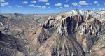
Cedar Breaks National Monument is a large amphitheater cliff in bright colors of red, orange and purple.
It lies east of Cedar City in the northern region of the scenery. The cliff was formed by erosion thru wind,
water and ice. Today erosion continues with a pace of about 2 inches every 5 years. Although it is called
Cedar Breaks, there are no cedars growing there but juniper trees. For a scenic flight to Cedar Breaks
National Monument best depart from Cedar City Regional Airport (KCDC) and head east. The scenery extends
south to Zion National Park and covers a large part of Zion Canyon and the Kolob Canyons area.
Zion National Park is another place where erosion of the Colorado Plateau formed the most beautiful colorful
stone formations of unique and wonderful shapes. There are nine different layers of stone visible in the park.
Most of them consist of sandstone. But there is also limestone, gypsum, siltstone, shale, clay and mudstone.
The Virgin River cut a spectacular and famous canyon thru Zion Park that is as narrow as 20ft and up to 2000ft tall.
High resolution versions of this scenery for FS9 and FSX (much sharper, but larger and multiple downloads)
are available at www.blueskyscenery.com/CNY_South2West5.html . The screenies are taken from the high-res versions,
so expect this version to be slightly more blurry.
Thanks to Joop Mak for providing a custom AFCADs that correct airport layouts so that they align with the photo-textures!
They are available here: www.blueskyscenery.com/AFCADs.html . YourDonation@Work: Dedicated to Richard, P.J. and Felix.
| Filename: | Zion_National_Park_North_Cedar_Breaks_National_Mon.zip |
| License: | Freeware, limited distribution |
| Added: | 14th March 2010, 00:30:28 |
| Downloads: | 1,564 |
| Author: | Gottfried Razek - blueskyscenery.com |
| Size: | 97.13 MB |
| Category: Flight Simulator 2004 - Scenery | |
| Zion National Park South, Hurricane (1L8), Colorado City (KAZC), Utah/Arizona, Photo-Scenery (FS9 & FSX) |
|
Images related to this file:
File Description:
Covers the southern part of Zion National Park extends south along the cities of Hurricane and Colorado City. Zion National Park is another place where erosion of the Colorado Plateau formed the most beautiful colorful stone formations of unique and wonderful shapes. There are nine different layers of stone visible in the park. Most of them consist of sandstone. But there is also limestone, gypsum, siltstone, shale, clay and mudstone. The Virgin River cut a spectacular and famous canyon thru Zion Park that is as narrow as 20ft and up to 2000ft tall.
High resolution versions of this scenery for FS9 and FSX (much sharper, but larger and multiple downloads)
are available at www.blueskyscenery.com/CNY_South3West5.html . The screenies are taken from the high-res versions,
so expect this version to be slightly more blurry. Thanks to Joop Mak for providing custom AFCADs that
correct airport layouts so that they align with the photo-textures! They are available at www.blueskyscenery.com/AFCADs.html . YourDonation@Work: Dedicated to Jerry, Ralph J. and Lance.
| Filename: | Zion_National_Park_South_Hurricane_1L8_Colorado_Ci.zip |
| License: | Freeware, limited distribution |
| Added: | 20th March 2010, 23:26:42 |
| Downloads: | 1,783 |
| Author: | Gottfried Razek - blueskyscenery.com |
| Size: | 95.39 MB |
| Category: Flight Simulator 2004 - Scenery | |
| Canyonlands National Park, The Maze-North, Utah, Photo-Scenery (FSX too) |
|
Images related to this file:
File Description:
This is a re-upload of a package that was corrupted during the crash of the AVSIM library. The Maze is the wildest and least accessible district of Canyonlands National Park. It is a perplexing jumble of canyons that has been described as a '30 sq miles puzzle in sandstone'. The Maze covers the area west of the Green River and north of the Colorado River. Getting to most locations requires multiple hours of 4WD road driving. Hiking trails usually require multi day backpack trips.
Too strenous? Let's go flying! Checking out the area from an eagles perspective is certainly a stunning experience. The colors are awesome and the landforms are of breathtaking beauty. The scenery extends my Arches National Park scenery to the west and brings you another 3.500 sq km in 4.7m/pix quality. YourDonation@Work: Dedicated to Frans, Francois and James. Thanks!
| Filename: | Canyonlands_National_Park_The_MazeNorth_Utah_Photo.zip |
| License: | Freeware, limited distribution |
| Added: | 31st December 2009, 11:01:39 |
| Downloads: | 2,371 |
| Author: | Gottfried Razek - blueskyscenery.com |
| Size: | 92.88 MB |
| Category: Flight Simulator 2004 - Scenery | |
| Canyonlands National Park, The Maze-South, Utah, Photo-Scenery (FSX too) |
|
Images related to this file:
File Description:
This is a re-upload of a package that was corrupted during the crash of the AVSIM library. This is the fourth package of the Arches/Canyonlands area. It covers the area southwest and including the confluence of the Colorado and Green Rivers. From there you can fly down Cataract Canyon which is famed for its premium whitewater rafting oportunities. Or explore the Maze (the area west of the Green and north of the Colorado River) with it's labyrinth of canyons and colorful sandstone formations. The scenery extends west to Hite (UT03) on Lake Powell. Brings the total Southern Utah coverage to 14.000 sq km in 4.7m/pix quality. YourDonation@Work: Dedicated to Patrick, Hideyuki and Art. Thanks!
| Filename: | Canyonlands_National_Park_The_MazeSouth_Utah_Photo.zip |
| License: | Freeware, limited distribution |
| Added: | 31st December 2009, 22:33:46 |
| Downloads: | 2,080 |
| Author: | Gottfried Razek - blueskyscenery.com |
| Size: | 95.67 MB |
| Category: Flight Simulator 2004 - Scenery | |
| Steamboat Springs (KSBS), Flat Tops Wilderness Area, Colorado - Photo-Scenery |
|
Images related to this file:
File Description:

Steamboat Springs (KSBS), Flat Tops Wilderness Area, Colorado, Photo-Scenery (FS9 & FSX)
The Flat Tops Wilderness Area, which is the second largest wilderness area in Colorado, is named for its many flat topped mountains that are clearly visible from the sky. Trappers Lake, located in the north of the area inspired Arthur Carhart, a US Forest Service official, to initiate a plea for Wilderness preservation as early as 1919. Finally in 1975, three years before his death in 1978, the Flat Tops were designated a wilderness area. No wonder he found the area so entrancing: Behind Trappers Lake loom majestic volcanic cliffs, and beyond them a vast subalpine terrain reluctantly yields to alpine tundra with an average elevation of about 10.000 feet. More than 100 lakes dot the country above and below numerous flat-topped cliffs. Steamboat Springs is an internationally known winter resort destination.
To explore the scenery depart from Steamboat Springs Airport (KSBS) or Yampa Valley Airport (KHDN) and head south. High resolution versions of this scenery for FS9 and FSX (much sharper, but larger and multiple downloads) are available at www.blueskyscenery.com/GNB_West2.html . The screenies are taken from the high-res versions, so expect this version to be slightly more blurry. Thanks to Joop Mak for providing custom AFCADs that correct airport layouts so that they align with the photo-textures! They are available at www.blueskyscenery.com/AFCADs.html . YourDonation@Work: Dedicated to James.
| Filename: | Steamboat_Springs_KSBS_Flat_Tops_Wilderness_Area_C.zip |
| License: | Freeware, limited distribution |
| Added: | 26th April 2010, 17:53:25 |
| Downloads: | 1,302 |
| Author: | Gottfried Razek - blueskyscenery.com |
| Size: | 91.57 MB |
| Category: Flight Simulator 2004 - AFCAD Files | |
| Honolulu International Airport, Honolulu, Oahu, Hawaii (PHNL) Crosswind Runways v2 |
|
File Description:
As requested this file is only for Lago's beautiful addon airport scenery this activates the crosswind rwy's adds 3 heli start locations and airport views from the roof of the control tower (only when in TOWER view) 8L/8R for take off and 4L/4R for landing fully tested with Ultimate Traffic but not required a big thanks to Jim Vile and Reggie Fields for their hard work in activating crosswind rwy's, Please note: this will not work with the default airport
| Filename: | Honolulu_International_Airport_Honolulu_Oahu_Hawai.zip |
| License: | Freeware |
| Added: | 18th October 2004, 04:01:08 |
| Downloads: | 1,699 |
| Author: | Ray Smith |
| Size: | 11.54 KB |
| Category: Combat Flight Simulator 1 and 2 - Aircraft | |
| F4U-1C "MARINE GREEN II" |
|
File Description:
Modified for DBolt's Improved Stock Model. This is probably as close to what I saw, belly down, rotting in the grass, at an airfield on Oahu over forty-five years ago. I've been told that Corsairs were never painted forest green (Marine green), and yet there they both were. I don't remember the markings, other than they both bore "Marines" or "USMC," so if any Marines out there would like to fly a Marine Green aircraft, here it is.
| Filename: | F4U1C_MARINE_GREEN_II.zip |
| License: | Freeware |
| Added: | 26th April 2006, 01:23:36 |
| Downloads: | 171 |
| Author: | Evan G. Butterbrodt |
| Size: | 4.92 MB |
| Category: Flight Simulator 2004 - Scenery | |
| DBWsim: Hickam AFB 2004 |
|
File Description:
The second DBWsim scenery pack for the Hawaiian island of Oahu follows up on DBWsim’s Pearl Harbour 2004 with DBWsim Hickam AFB 2004. This scenery pack covers primarily Hickam AFB in the west of the Honolulu International airport region, as well as a significant overhaul of the Honolulu International Airport area. This scenery is designed to complement DBWsim Pearl Harbour 2004 and is intended for use with (but will operate independant of) Bill Melichar’s ‘FS2004, Honolulu International Airport, Version 5’.
| Filename: | DBWsim_Hickam_AFB_2004.zip |
| License: | Freeware |
| Added: | 14th November 2004, 20:19:05 |
| Downloads: | 9,022 |
| Author: | Derek and Brendan Webb |
| Size: | 2.64 MB |
© 2001-2026 AVSIM Online
All Rights Reserved
Privacy Policy |