
Where Flight Simulation Enthusiasts Gather from Around the World!
AVSIM Library - Search Results

| Category: Flight Simulator 2004 - Aircraft Repaints, Textures and Modifications | |
| Boeing 767-300 and 767-400 v5 Antenna Updates |

|
Images related to this file:
File Description:

Combined Antenna Updates for SKYSPIRIT2010 BOEING 767-300 and 767-400ER v5 for FS2004 | Air Europa Boeing 767-3Q8/ER EC-HSV
- Air Seychelles Boeing 767-37D/ER S7-AHM
- S7 Airlines - Siberia Airlines Boeing 767-33A/ER VP-BVH
- Air Seychelles Boeing 767-306/ER S7-FCS
- Kenya Airways old and new colours Boeing 767-36N/ER 5Y-KQX
- LOT - Polish Airlines / Polskie Linie Lotnicze Boeing 767-306/ER SP-LPG
- Air Namibia Boeing 767-33A/ER V5-NMB
- El Al Israel Airlines Boeing 767-3Y0/ER 4X-EAP
- Nationwide Airlines Boeing 767-3Y0/ER ZS-PBI
- British Airways NC Boeing 767-336/ER G-BNWX
- British Airways OC Boeing 767-336/ER G-BNWX
- Boeing World Tour - 'Leading the Way' Boeing 767-432ER N76400
- Continental Airlines Boeing 767-424/ER N66051
- United Airlines (Continental Airlines) Boeing 767-424/ER N69059 |
Masters and Liveries by Philip Foglar.
| Filename: | Boeing_767300_and_767400_v5_Antenna_Updates.zip |
| License: | Freeware, limited distribution |
| Added: | 28th July 2011, 21:30:43 |
| Downloads: | 1,292 |
| Author: | Philip Foglar | SkySpirit2010 Team |
| Size: | 235.31 KB |
| Category: Flight Simulator 2004 - Scenery | |
| Tokyo Bay 2005 |
|
Images related to this file:
File Description:
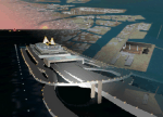
FS2004 Scenery Tokyo Bay Scenery 2005 Ver. 5.0
This add-on scenery improves specific scenerys (Tokyo Bay, Japan) of FS2004.
There are a lot of reclaimed land in Tokyo Bay.
They form an artificial peculiar coastline. This scenery reproduces these coastlines precisely.
And, this scenery reproduces the Keihin industrial area and the Keiyo industrial area in Tokyo Bay located west and east. In this scenery design, the coastline was reproduced as exactly as possible, following the specification of FS2004.
Moreover, 90m mesh geographical data is reproduced by using SRTM 3arc/sec.
The range of detailed coastline and 90m digital elevation data is as follows:
** [detailed coastline] N33:45 E138:45 to N36:55 E141:05 (included Izu Islands)
** [90m digital elevation data] N33:00 E138:00 to N37:00 E141:00 --
The Tokyo Wan AquaLine is arranged in the exact location. By Kazuo Kawamura
| Filename: | Tokyo_Bay_2005.zip |
| License: | Freeware, limited distribution |
| Added: | 3rd December 2011, 23:51:31 |
| Downloads: | 11,794 |
| Author: | Kazuo Kawamura |
| Size: | 9.74 MB |
| Category: Flight Simulator 2004 - Scenery Design | |
| Library Object Manager with Scenery Maker Version 0.99 |
|
File Description:
This is the final beta release of this program.
Library Object Manager is a utility to manage your collection of FS9 Library Objects. It can import information from a number of sources including library files, SBuilder, RWY12 and EZ-Scenery. It can export information about objects to SBuilder, EZ-Scenery, RWY12 and other Secnery Design Programs. You can catalog objects by libary, user defined category and author. If you have a lot of objects then LOM makes using them in your scenery very much easier.
Scenery Maker is part of LOM and tightly integrated with it. It uses the database of objects. Scenery Maker is a placement program and uses your Flight Sim aircraft position to place objects (Similar to RWY12).
Works only with FS2004 objects and Simulator. Requires Microsoft dotNET Framework Version 2 and bglxml. Full details are in the download documentation. Support is available from http://www.scruffyduck.plus.com
| Filename: | Library_Object_Manager_with_Scenery_Maker_Version_.zip |
| License: | Freeware |
| Added: | 14th May 2006, 15:10:26 |
| Downloads: | 4,937 |
| Author: | Jon Masterson |
| Size: | 5.96 MB |
| Category: Flight Simulator 2004 - Panels | |
| VFR/Landing View for "Level-D Simulations: The 767" |
|
File Description:
After a lot of hard work, and help and advice from 757/767 captains, I'm proud to release this small add-on for "Level-D Simulations: The 767"! This view has been verified by pilot's to be close to the "real-thing"! I have created two styles of these panels. One with the Radar-Altimeter tape (like AAL and Delta use on their 767-300s) and one without (like UAL). Both were made to work more seemlesly with PIC 767. Landing your 767 will never be the same again... Special thanks to "Jake" at www.airliners.net; without his input and photos, this panel would not exist.
DISCLAIMER: THESE FILES ARE THOROUGHLY TESTED. HOWEVER, THEY ARE TO BE USED AT YOUR OWN RISK!!!
Level-D is not responsible for any modifications to their product. Send an E-Mail to [email protected] with any comments or technical difficulties!
| Filename: | VFRLanding_View_for_LevelD_Simulations_The_767.zip |
| License: | Freeware, limited distribution |
| Added: | 18th October 2005, 10:22:05 |
| Downloads: | 5,293 |
| Author: | Philip A. Geddes |
| Size: | 863.24 KB |
| Category: Flight Simulator X - Scenery | |
| FSX-VTSP-Phuket |
|
File Description:
now it starts as always, I can't find a usable freeware airport in this case for the
VTSP - Phuket Thailand so I'll build it myself again ...............
now what can I say after a lot of work it is built as real as possible with many details
with the standard scenery ..........
So fly to Phuket. Currently there are flights from Bangkok with Bangkok Airways,
but there are also some direct flights from Qatar via Munich and Doha with the
Dreamliner
Installation:
Copy the folder VTSP -Phuket into the addon folder of the FSX, start the FSX, go to
settings, change the scenery library, add the area, press OK, then you can start ....
Extras:
in order to be able to see people I deliver the file 3DPeoble_Lib with this you can
also copy into the addon folder and activate it in FSX as described during the
installation and you will see people ..............
| Filename: | FSXVTSPPhuket.zip |
| License: | Freeware |
| Added: | 10th March 2021, 20:30:15 |
| Downloads: | 1,248 |
| Author: | Ewald Wagner |
| Size: | 51.85 MB |
| Category: Flight Simulator X - Flight Plans | |
| Chas mod of Stearmandriver RNP RNAV Approach into PAJN Rwy 26 for 737NGX |
|
Images related to this file:
File Description:
Modded StearmanDriver(SD) RNP RNAV Rwy 26 into PAJN, Juneau, Alaska. SD gave us a cool little route that while not LATLONG nor Fixname accurate, it couldn't be without legal and occupational liabilities...and it worked, but if you look at his FixNames and the LATLONG from the PAJN.txt file for the 737 NGX...it did work pretty nicely...at least as nicely as the charted RNAV course into Rwy 8. So I created my own procedure LATLONG rightly or wrongly in a multi-step procedure as follows:
1. I took the raw info provided by SD and flew to each of his waypoints,(if you look, almost all of his FIXs were rounded off...to avoid company or legal problems) noting safe altitude, starting out at 7000ft, creating user waypoints in my GTN750, looking around for first, vertical, then horizontal safety...keeping in mind that Ultimately...I would not be using this data for my Duke, but for the Procedure page of my PMDG 737 NGX..which you already saw me fly with SD's fixes.
2. I took my Turbine Duke up and noted the REAL LATLONG as reported by slewing and world map...transposed those numbers into the format that PMDG's procedures needed DDD.mm fractional minutes. I converted using http://www.directionsmag.com/site/latlong-converter/
3.I created my own mid-point user waypoints from the west CHRTRN,and the NNE CHRTS so we could have approaches from those directions.
4. I put my Duke into autopilot, knowing the lateral info...my flightplan was correct, but I would have to handle the Vnav manually. Turns out its rather manageable with the following info: CHRTRN 5000FT - MARMN 3500FT - TRDWL 2500FT - SALMN 1500 - LEMNN 500 - PAJN5 50
My MOD OF SDs RNP RNAV PAJNRwy 26, will be up on Avsim as ChasModRNP RNAV PAJN Rwy 26.zip
Contact:[email protected] - Support: http://forum.avsim.net/topic/466094-any-interest-in-updated-se-alaska-rnav-rnp-approach-procedures-including-juneau/
| Filename: | Chas_mod_of_Stearmandriver_RNP_RNAV_Approach_into_.zip |
| License: | Freeware |
| Added: | 8th May 2015, 11:35:16 |
| Downloads: | 340 |
| Author: | Chas Reed |
| Size: | 144.78 KB |
| Category: Flight Simulator X - Aircraft Repaints, Textures and Modifications | |
| Southwest "California One" 737-800 WL V2 (FIX) |
|
Images related to this file:
File Description: The current SWA California One is a
737-300 [737-3H4, N609SW] which SWA, may someday, replace with a newer, larger
version. This is my rendition of the California One scheme as it might look if
applied to a 737-800NGX. I tried to keep it as true to the current scheme as
possible within the limitations of the PMDG paintkit, but there are some areas
where I had to use a little artistic license in order for it to apply to the 800
NGX without looking odd. This is a full .ptp package and requires the PMDG
livery manager for installation. NOTE: If you downloaded the original
version, please replace it with this one . This file completely replaces
Southwest "California One" 737-800 WL. Unfortunately, there
were some errors in the Alpha Channels of the original .dds files that made
strange things happen to the fuselage especially at night.

| Filename: | Southwest_California_One_737800_WL_V2_FIX.zip |
| License: | Freeware |
| Added: | 14th November 2012, 06:50:11 |
| Downloads: | 2,668 |
| Author: | David Blitch |
| Size: | 13.05 MB |
| Category: Flight Simulator X - Utilities | |
| Boeing 737 Dispatch sheet v 4.9.5 |
|
Images related to this file:
File Description:
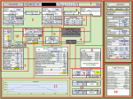
The 737 Dispatch sheet is a comprehensive dispatcher, fuel planner and performance calculator in Excel 2007 and above. It is designed to be used with the PMDG NGX and its ranges of engine and weight variants and other options such as Short Field Package and winglets. Calculations are based on many available optional user inputs such as selected Cost Index, weather information, altitudes en route, altitude steps, passenger load, luggage, and many other factors that impacts fuel usage and aircraft performance. The calculations include takeoff and landing weights as well as estimated flight time, cruise speeds and more. The build in airport and runway database helps you find all the information you would need to plan your flight including takeoff performance settings, engine derates, assumed temperatures, landing configuration, landing and takeoff speeds, and more. This updated version includes a unit change feature for baro settings similar to the distance and weight unit selectors as well as a few other corrections and additions.
| Filename: | Boeing_737_Dispatch_sheet_v_495.zip |
| License: | Freeware |
| Added: | 28th October 2013, 16:32:56 |
| Downloads: | 9,153 |
| Author: | Lasse Kronborg |
| Size: | 8.63 MB |
| Category: Flight Simulator X - Aircraft Repaints, Textures and Modifications | |
| Ryanair Boeing 737 MEGA Pack (EI-EXE / EI-DCL) |
|
Images related to this file:
File Description:

Ryanair is an Irish low cost airline. Its headquarters is located in Swords, County Dublin, Ireland, with its primary operational bases at Dublin Airport and London Stansted Airports.
Ryanair livery painted on PMDG Boeing 737 NGX WL model. The textures are saved in DDS format for quality graphics. Textures are also characterized by HD (High Definition). Its features are idle-reverser animation, animated pack vents and pressurisation outflow valve, detailed textures, accurate paint, dynamic shine & effects, dynamic flexing wings that respond to turbulence, fully independent suspension, trim animation, gear steering, accurate flight dynamics, spoiler animation, reflective cockpit windows, improved wingflex code with input from several new parameters including ground spoilers, fuel load, and angle of attack, transparent navigation light lenses and many more. "HD EXPERIENCE" INSIDE. Credits to PMDG Simulations.
Visit our Facebook page "Sky Level Textures" for news, updates and previews on my future repaint projects. Thanks for downloading & Happy flying.
| Filename: | Ryanair_Boeing_737_MEGA_Pack_EIEXE__EIDCL.zip |
| License: | Freeware |
| Added: | 20th May 2014, 22:50:56 |
| Downloads: | 6,862 |
| Author: | Giacomo Tomasini | Sky Level Textures | PMDG Simulations |
| Size: | 75 MB |
| Category: Flight Simulator X - Scenery | |
| Murray river + SE victoria airports ****UPDATED****. YRIO Robinvale YBRN Balranald YDLQ Deniliquin YLEG Leongatha YYRM Yarram |
|
Images related to this file:
File Description:
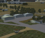
This is an updated version (original July 2018) with some ground texture problems fixed plus a lot of added and improved objects. There are 5 airports. 3 airports near the Murray river in Victoria and NSW - YRIO Robinvale, YBRN Balranald, YDLQ Deniliquin. 2 airports in SE Victoria - YLEG Leongatha, YYRM Yarram. A few airports but this is no quicky slap dash effort but hundred+ hours. Surrounding scenery modified to match real life. Towns have been added or shifted. Forests cut down or added. Race courses, sewage treatment ponds and other stuff added. Local obstacles (towers etc) added. Included are 2 AI traffic files that covers the airports. These files are for Flight Simulator X. Made using Airport Design Editor using some objects borrowed from Robert Budd's excellent Baccus Marsh. RECOMMENDED The scenery is designed to interface with ORBX FTX_AU scenery for Australia (payware). It will work without ORBX but will not interface as well with standard scenery.
| Filename: | Murray_river__SE_victoria_airports_UPDATED_YRIO_Ro.zip |
| License: | Freeware |
| Added: | 22nd February 2019, 18:09:09 |
| Downloads: | 272 |
| Author: | Colin Jeffery |
| Size: | 3.44 MB |


© 2001-2026 AVSIM Online
All Rights Reserved
Privacy Policy |