
Where Flight Simulation Enthusiasts Gather from Around the World!
AVSIM Library - Search Results

| Category: Dovetail Games Flight Sim World - Aircraft Repaints, Textures and Modifications | |
| FS2004 aircraft.cfg & panel.cfg & for use in FSW |

|
File Description:
aircraft.cfg & panel.cfg files to avoid the startup error message.
| Filename: | FS2004_aircraftcfg__panelcfg__for_use_in_FSW.zip |
| License: | Freeware |
| Added: | 27th November 2017, 18:53:07 |
| Downloads: | 60 |
| Author: | Paul Kemp |
| Size: | 578.13 KB |
| Category: Flight Simulator 2004 - Aircraft Repaints, Textures and Modifications | |
| A3 Skywarrior in VAQ-34 Aggressors scheme |
|
Images related to this file:
File Description:
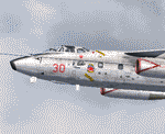
Re-uploaded repaint for the Alphasim A3 Skywarrior in VAQ-34 (Aggressors).
| Filename: | A3_Skywarrior_in_VAQ34_Aggressors_scheme.zip |
| License: | Freeware |
| Added: | 15th May 2010, 01:54:19 |
| Downloads: | 915 |
| Author: | Repaints by pierre lheureux - Plane by Alphasim |
| Size: | 1.76 MB |
| Category: Dovetail Games Flight Sim World - Panels | |
| FSX c172 panel for use in FSW |
|
File Description:
A basic c172 panel to fill in the holes left by missing gauges when using the default FSX Cessna c172 in FSW.
| Filename: | FSX_c172_panel_for_use_in_FSW.zip |
| License: | Freeware |
| Added: | 15th August 2017, 00:25:07 |
| Downloads: | 97 |
| Author: | Paul Kemp |
| Size: | 794.19 KB |
| Category: Flight Simulator 2004 - Aircraft Repaints, Textures and Modifications | |
| Tu-114 in Aeroflot 90's Livery |
|
File Description:
Repaint of Samdim's beautiful model in realistic weathered Aeroflot 90's livery used for secondary national destinations. New markings are painted over the old communist ones which are still subtly visible in parts due to wear. This TU-114 has seen decades of service and is still going strong!
| Filename: | Tu114_in_Aeroflot_90s_Livery.zip |
| License: | Freeware |
| Added: | 18th September 2004, 00:42:35 |
| Downloads: | 2,524 |
| Author: | Sascha Rieger |
| Size: | 29.01 MB |
| Category: Flight Simulator X - Missions | |
| Emergency in Nantes - Save a captain Tanker |
|
File Description:
Mission in helicopter.
Leave the airport of Nantes to help the commander of a tanker which goes up the Loire and must set out to the deep sea before the low tide. Take it along to the Urgencies of the Hospital where it must be operated without waiting.
| Filename: | Emergency_in_Nantes__Save_a_captain_Tanker.zip |
| License: | Freeware, limited distribution |
| Added: | 3rd October 2007, 14:38:28 |
| Downloads: | 5,908 |
| Author: | Marc-henri Guitteny |
| Size: | 6.84 MB |
| Category: Flight Simulator 2004 - Scenery | |
| St Andre-Avellin CAA2 in Quebec Canada |
|
Images related to this file:
File Description:
St Andre-Avellin is a new airfield in Quebec Canada, 35 miles east of Ottawa and 10 miles north of the Ottawa River, and just northwest of the village of the same name. There is a 03/21 grass runway that is 2,870 feet long and slopes up towards the north. To show this slope I have not "placed" a grass runway (which would immediately flatten the slope) and anway there is not so much traffic that the grass would be notably marked. Because of the lack of an FS-recognised runway I have not made parking or a traffic file as AI would not work; anyway this airfield with constant activity would not reflect reality. There are no facilities at the airfield except a hangar for the owner and space to park.
| Filename: | St_AndreAvellin_CAA2_in_Quebec_Canada.zip |
| License: | Freeware, limited distribution |
| Added: | 9th April 2011, 20:49:47 |
| Downloads: | 168 |
| Author: | Roger Wensley |
| Size: | 816.9 KB |
| Category: Flight Simulator 2004 - Scenery | |
| Aklavik CYKD in the Northwest Territories, Canada |
|
Images related to this file:
File Description:
Aklavik is a town of 650 or so inhabitants at N68 W135, which means 120 miles inside the Arctic Circle and on the West Channel of the Mackenzie River delta. It is 40 miles west of Inuvik and around 60 miles from where the Mackenzie meets the Beaufort Sea. There is only one airline serving the town on a regular basis and that is North Wright, which is headquartered in Norman Wells and also has a base in Inuvik. Aklavik village does not feature in FS9, so the first thing to do was to add it; not all the smaller streets are in place but it is the right shape and with around the right number of houses. The only building with (partly) correct textures is the school near the airfield. I couldn't begin to model 150+ houses, so think of it as a hand-made auto-generated village. I had to move the airfield over beside the river, so there is a DELETE file and a GRASS file, as well as an AFCAD for AI (the AI will follow later) and a scenery file.
| Filename: | Aklavik_CYKD_in_the_Northwest_Territories_Canada.zip |
| License: | Freeware, limited distribution |
| Added: | 10th October 2010, 03:02:19 |
| Downloads: | 628 |
| Author: | Roger Wensley |
| Size: | 1.91 MB |
| Category: Flight Simulator 2004 - Scenery | |
| Grande Prairie CYQU in Alberta, Canada, Updated |
|
Images related to this file:
File Description:
This is a new version of the original post from March 2014, made in 2018. It was made mainly to provide some missing textures, but has been modified to also add parked trucks and floodlights to the de-icing area (the floodlights are inoperative as they will not be on when there is no de-icing in progress) and also street and car parking lighting, a few more parked planes, and some further objects on the terminal apron area. The runway approach lighting was also corrected; moving the airport so that the ILS on 29 did not coincide with the roads would have been nice, but meant too many complications at this stage. The scenery is complete in itself and can be installed as-is if you do not have the original post. Grande Prairie is at 2,195 feet asl, 65 miles southeast of Dawsons Creek, 90 miles southwest of Peace River and around 60 miles east of the Rockies. The town has a population of around 55,000 and growing. The name comes from the wide expanse of prairies all around the town, and there is also a large forested area to the southwest leading up to the Rockies which supplies raw material for industries in the town. The airport is just to the west of the town. It was originally a military base, built during WW2. The two runways are 07-25 and 11-29 and 6,200 and 6,500 feet respectively, both 200 feet wide; runway headings had changed by 2010 in real life but take this as it was in 2008. When one is the active runway then the other is used as a taxiway. Taxiway A is very wide with in real life a repaired central section marked out for use.
| Filename: | Grande_Prairie_CYQU_in_Alberta_Canada_Updated.zip |
| License: | Freeware, limited distribution |
| Added: | 13th December 2018, 04:12:11 |
| Downloads: | 207 |
| Author: | Roger Wensley |
| Size: | 34.97 MB |
| Category: Flight Simulator 2004 - Scenery | |
| Anahim Lake CAJ4 in British Columbia, Canada |
|
Images related to this file:
File Description:
Anahim Lake is around 55 miles east of Bella Coola by air, and clear of the deep and rugged valley that connects the two with a road that is over 75 miles long. The two are also linked by a daily Pacific Coastal flight. A further 150 miles east is Williams Lake (200 miles by road). The town of Anahim Lake is small, but renowned for numerous surrounding fishing lodges on the lakes and the enjoyment of "nature" in what is known as the Chilcotin Wilderness. The Anahim Lake airport is an odd one. It appears to have fallen into disuse over a period of years, but is now in the process of being upgraded, with some new hangars (though oddly situated, and with only dirt track taxiway access) and a recently completed terminal building. There is also a plan to upgrade the runway (lights etc, there are currently no runway or taxiway lights) and in general to greatly improve the facilities on offer. The only current airline to fly there is Pacific Coastal. The runway is just under 4,000 feet of asphalt aligned 13-31 and 75 feet wide. There used to be another runway which is still visible but is now unusable, gravel that has not been maintained for several years. The notes for Anahim Lake airfield in the Nav Canada manual warn of "Extensive float plane activity at Nimpo Lake to the south" and of "possible large animals within the airport perimeter". Nimpo Lake activity will follow in further posts.
| Filename: | Anahim_Lake_CAJ4_in_British_Columbia_Canada.zip |
| License: | Freeware, limited distribution |
| Added: | 29th November 2018, 19:21:59 |
| Downloads: | 152 |
| Author: | Roger Wensley |
| Size: | 5.72 MB |
| Category: Flight Simulator 2004 - Scenery | |
| Port McNeill CAT5 in British Columbia, Canada |
|
Images related to this file:
File Description:
Port McNeill is at the northern end of Vancouver Island, on the coast and around 20 miles east of Port Hardy. The town population is just over 2,000 and the main industry is logging, followed by sand and gravel quarrying and exporting for the construction industry. Tourism rates third.
The airport, a mile or so east of the town, provides a swift connection for nearby islands and the surrounding area to the rest of the west coast, and serves as the HQ main base for West Coast Helicopters. Their newly built large hangar and office accommodation is next to their older hangar to one side of the central public parking area, opposite the club house cum terminal and hangars. There are two runways: 06-24 which is asphalt, 2,400 feet long, and lit; and 11-29 of gravel, 3,650 feet long and also lit. There is some taxiway lighting, but not, for instance, for the connection between runways, which is in real life a ramp up to the gravel runway which is 15 feet higher. There are no regularly scheduled flights and traffic consists mainly of the West Coast helicopters, plus GA and irregular charters, the latter being mostly from Port Hardy.
| Filename: | Port_McNeill_CAT5_in_British_Columbia_Canada.zip |
| License: | Freeware, limited distribution |
| Added: | 18th November 2018, 05:49:13 |
| Downloads: | 136 |
| Author: | Roger Wensley |
| Size: | 13.29 MB |
© 2001-2026 AVSIM Online
All Rights Reserved
Privacy Policy |