
Where Flight Simulation Enthusiasts Gather from Around the World!
AVSIM Library - Search Results

| Category: Flight Simulator 2004 - Scenery | |
| Qikiqtarjuaq CYVM (Broughton) and DEW FOX-5 in Nunavut, Canada |

|
Images related to this file:
File Description:
Qikiqtarjuaq is an airfield on the northeast coast of Baffin Island, just over 100 miles north of Pangnirtung. The airfield is the closest Canadian airfield to Greenland and is used for ferry flights from Canada to Europe for small planes, though there is normally only JetA1 fuel available. The airfield is at only 18 feet ASL next to the sea with the village to the north; it was previously (before 1998) called Broughton Island. The runway is 3,800' of 100' wide gravel and is lighted; as it is in the Northern Domestic Airspace the runway is signed as 033T-213T, using "true" bearings instead of magnetic. There is a terminal and a small maintenance building on the apron and these have been modeled specifically for this scenery. There are AI parking spots; the AI visiting aircraft are a Canadian North Dash 8 and a First Air 42-300. Qikiqtarjuaq village is just north of the airfield and has a population of around 520; it is approximately the right size and shape but no buildings were specifically modeled for the village. There is also a North Warning System site called Fox-5 to the northeast, and this too is included. You will need Ultimate Terrain Alaska Canada.
| Filename: | Qikiqtarjuaq_CYVM_Broughton_and_DEW_FOX5_in_Nunavu.zip |
| License: | Freeware, limited distribution |
| Added: | 14th June 2011, 02:04:26 |
| Downloads: | 555 |
| Author: | Roger Wensley |
| Size: | 1.85 MB |
| Category: Flight Simulator 2004 - Scenery | |
| VGCB Cox's Bazar, Bangladesh |
|
File Description:
Googly scenery for VGCB Cox's Bazar, Bangladesh, a small domestic airport
serving the fishing town of the same name in the Bay of Bengal, to the
south of Chittagong. It boasts extensive sandy beaches which has allowed
tourism development. The unusual name comes from Captain Hiram Cox of the
British East India Company who was appointed Superintendent of the outpost
in the late 1700s. The airport, which was originally a Pakistan Air Force
base, sees domestic flights (mostly to/from Dhaka) operated by Hawker
Siddeley 748s, de Havilland Dash 8s and Fokker Fellowship aircraft of Biman
Bangladesh Airlines, GMG Airlines, United Airways and Zoom Airlines.
Flight Simulator 2004 has made no provision for traffic with only a runway
provided and this scenery seeks to redress the situation.
The scenery does not purport to be ultra-accurate. Based on high quality
satellite imagery from Google Earth, the layout is proportionally correct but the
added airport features, such as buildings, are built from default Microsoft objects
and add-on libraries so will not look exactly like the real thing.
You are not obliged to download and install any additional scenery libraries,
but to enjoy this scenery in its entirety, you may wish to. It will work fine,
with or without.
| Filename: | VGCB_Coxs_Bazar_Bangladesh.zip |
| License: | Freeware |
| Added: | 14th April 2008, 21:13:08 |
| Downloads: | 1,350 |
| Author: | John Hinson |
| Size: | 67.71 KB |
| Category: Flight Simulator X - Scenery | |
| PLAN Fleet |
|
Images related to this file:
File Description:

Here is a mighty PLAN fleet, capable of respectable force projection anywhere within the nine dash line and even beyond! I tried to find the Chinese Navy crest, similar to the one I used to represent my US Navy collection, but the only thing available anywhere is a depiction of the Peoples Liberation Army Navy flag.
These ships are currently assigned to the South Sea Fleet and so might be present at any of the events in the disputed South China Sea.
The LST YutingII/Type 072a Luhua Shan, pennant number 997, is the same type vessel that participated in the "near collision" with USS Cowpens recently. Now you can re-enact how a 18 knot transport was able to in any way interfere with the 32 knot Arleigh Burke class destroyer. Also in this fleet are two Houbei class missile boat catamarans, the Yuzhao class type 071 amphibious transport dock Changbai Shan, Luyang II/Lanzhou class type 052C destroyer DDG-171 Haikou and the Jiangkai II class type 054A frigate Hengshui.
All ships have landable decks, animated effects and night lights, Haikou has an animated Z-9 helicopter escort.
The ships are intended for placement with AICarriers, by Lamont Clark.
| Filename: | PLAN_Fleet.zip |
| License: | Freeware, limited distribution |
| Added: | 15th June 2014, 05:55:02 |
| Downloads: | 500 |
| Author: | Rick Keller |
| Size: | 31.7 MB |
| Category: Flight Simulator X - Scenery | |
| TNCB - Flamingo Airport (Bonaire) |
|
File Description:
Welcome to one of the 3 ABC's beautifull dutch island, Bonaire.
Flamingo Intl. is an international airport located at Kralendijk, Bonaire, Netherlands Antilles. Flamingo Airport serves as a connecting
point for flights of KLM to some destinations in South America. It once served as a hub for BonaireExel, BonaireExpress,CuraçaoExel,
CuraçaoExpress and now serves Dutch Antilles Express as it's secondary hub & also "EZAir" serves Bonaire as its main airline, although
the airline itself is based at Curaçao.
It is the 3rd largest airport in the Netherlands Antilles behind St.Maarten's Princess Juliana International Airport & Curaçao's Hato
International Airport and is the 4th largest between the islands of the Dutch Kingdom behind the already mention St. Maarten,
Curaçao & Aruba's Queen Beatrix International Airport. Arkefly, Continental, Delta & KLM are currently the largest airline operators
that operate flights to Bonaire.
The airport is large enough to accommodate most international widebody airliners such as the Boeing 747, the Boeing 777 and the
Airbus A340, although the largest widebody type to operate to Bonaire today is the MD11. It can also accommodate medium sized
aircraft such as the Boeing 737 and Airbus A310 as well as small aircraft such as the de Havilland Dash 8, ATR 42 and other such
turboprop aircraft.
| Filename: | TNCB__Flamingo_Airport__Bonaire.zip |
| License: | Freeware |
| Added: | 13th April 2009, 08:00:18 |
| Downloads: | 2,342 |
| Author: | Daniel Louvet |
| Size: | 1.01 MB |
| Category: Flight Simulator 2004 - Aircraft Repaints, Textures and Modifications | |
| Era Alaska Beechcraft B1900D (N972EA) |
|
Images related to this file:
File Description:

I am very proud to present this detailed repaint of PMDG's Beechcraft B1900D in the fabulous red, black and white livery of Era Alaska, registration N972EA. Era Alaska, formed in 2009 and based in Anchorage (PANC), is the combination of Era Aviation, Hageland Aviation and Frontier Flying Service. Era provides cargo service as well as scheduled passenger service and flies a fleet of 3 B1900D's, using them along with the Dash-8-100 as workhorses for passenger destinations throughout Alaska. This is a very detailed and realistic repaint. The inside of the winglets have the Era logo, fuse and tail stripes are as accurate as I could get them, the wings have the red stripe and black band on the top and bottom, the fonts for the Era logo and FlyEra.com are the actual fonts used by Era, door markings are hand painted, interior seats and floor (carpet) are red as in the real aircraft, fuse shading is custom, tail shading is custom, tail logo is hand painted and the cap on fore part of the upper vstab is painted black. All repainted textures in this package are 32-bit with no mipmaps. I hope you enjoy flying this great aircraft around Alaska. This is a textures only package, you must own the payware PMDG B1900D to enjoy it.
| Filename: | Era_Alaska_Beechcraft_B1900D_N972EA.zip |
| License: | Freeware, limited distribution |
| Added: | 23rd March 2011, 08:15:07 |
| Downloads: | 1,099 |
| Author: | Jeffrey S. Bryner, PMDG |
| Size: | 8.87 MB |
| Category: Flight Simulator 2004 - Scenery | |
| Valdez Pioneer Field PAVD in Alaska |
|
Images related to this file:
File Description:
Pioneer Field is in Valdez Alaska, between the mountains to the north and the water of Valdez Arm to the south. It used to cater for a lot of the work for the Alaskan pipline and the nearby terminal and in the middle 1970's it was a very busy place. That is not the case now, and the tower is no longer manned though there is still an average of 35 flights a day and there are 30 planes (and helicopters) based at the field. There are three really odd hangars at the western end of the apron, with each of them having 6 "T" hangars which have been joined in a circle; this is the only place I have ever seen this. The recently resurfaced runway is 6,500 feet of 150 feet wide asphalt aligned 6/24 at 121 feet asl. There is also a wide and heavy duty asphalt and gravel surrounding runoff and base, probably because of drainage problems with water from the mountains. Fuel (both JetA and 100LL) is available from ERA Helicopters at the eastern end of the apron. All of the buildings on the field have been modelled specifically for this scenery, plus the nearby accomodation blocks. The AI flights are for the twice-daily ERA/Alaska Air flights using a Bombardier Dash 8-200.
| Filename: | Valdez_Pioneer_Field_PAVD_in_Alaska.zip |
| License: | Freeware, limited distribution |
| Added: | 21st January 2011, 03:29:51 |
| Downloads: | 1,198 |
| Author: | Roger Wensley |
| Size: | 3.97 MB |
| Category: Flight Simulator 2004 - Scenery | |
| Avon STOLPort (KWHR) |
|
File Description:
A recreation of the Avon STOLPort (ident KWHR) for MS Flight Simulator 2004, A Century of Flight. Avon was operated as an exclusive destination for Rocky Mountain Airways between (approximately) 1978 and sometime in the late 80's or early 90's. The 4,000' runway was short for the nearly 7,500' elevation, and surrounded by mountains, some towering over 6,000' above the airport elevation. To allow all weather operation, the airport eventually featured what was reported as the steepest ILS ever constructed, with a seven degree glideslope. RMA had exclusive use of the tiny STOLPort and operated it with 50-passenger De Haviland Dash 7 equipement.
Lacking the original chart, I surveyed in FS and plotted what is hopefully an accurate representation of the ILS approach, using my best understanding of TERPS - the US standard for instrument approaches. I also created an NOS-style IAP chart of this approach for the package. A text Takeoff Minimums & Procedure is also included.
AI ATC & traffic recognition of the approach will hopefully follow, but does not exist yet. In other words, you can fly this approach and see the localizer in the GPS, but AI ATC will not give you vectors to it. You'll need to follow the full procedure included on the chart.
Please see the full Readme.txt in "Flight Simulator 9\Addon Scenery\KWHR\Docs" in this zipfile for information on installation of the scenery, flying the approach, and more on the history of the Avon STOLPort.
| Filename: | Avon_STOLPort_KWHR.zip |
| License: | Freeware, limited distribution |
| Added: | 12th May 2008, 23:14:38 |
| Downloads: | 418 |
| Author: | Stephen Comer |
| Size: | 2.1 MB |
| Category: Flight Simulator 2004 - Scenery | |
| Ulukhaktok (Holman) CYHI in the Northwest Territories, Canada |
|
Images related to this file:
File Description:
Ulukhaktok (Holman) is an airfield on the west side of Victoria Island, off the northern coast of Canada. It is 320 miles west of Cambridge Bay (and you should download and install the recent post of CYCB by Sid and Pete, as I use it for the AI included in this post) and around 400 miles east of Inuvik (my post of a few months ago). It has been officially called Ulukhaktok since 2006, and before that it's name was Holman.
The village of Ulukhaktok has been placed around the bay and is approximately the right shape; it houses some 460 people who used to rely solely on hunting and fishing. The village is close to 71 degrees north, and there are only four months of the year when the average high is above zero centigrade. The photograph with snow (and of course a frozen sea) is typical; for the frozen sea download my Frozen Rivers & Lakes post which will provide this. The buildings on the field have been modelled specifically for this scenery, and as in real life there is only JetA available. The AI visiting aircraft are an Aklak Air DC3 (based in Inuvik and operated by Kenn Borek Air) and a Canadian North Dash 8-100. Note that the runways are signed as "true" headings instead of magnetic; in the Canadian Northern Domestic Airspace all headings are given as true. Unfortunately FS9 doesn't accommodate this in ATC.
| Filename: | Ulukhaktok_Holman_CYHI_in_the_Northwest_Territorie.zip |
| License: | Freeware, limited distribution |
| Added: | 24th May 2011, 20:05:47 |
| Downloads: | 452 |
| Author: | Roger Wensley |
| Size: | 2.3 MB |
| Category: Flight Simulator 2004 - AFCAD Files | |
| La Guardia |
|
File Description:
A high quality AFCAD2 file the New York La Guardia (KLGA) scenery by Shehryar Ansari. This file features assigned gates for all airlines that currently serve LGA. In order to ensure only 'mainline' aircraft use the jetbridges, a new 'Express' apron for Dash 8 and RJ size aircraft is provided near the Central Terminal and also adjacent to the US Air and Delta Terminals. An extensive GA parking area has also been added to the west side of the airport and includes 4 Helipads. A tower view is provided for the airport and both runways are also in use to maximize traffic flow. The Marine Terminal (Delta Shuttle) and US Airways (Shuttle) areas now have seperate parking codes. The txt for these codes is included in this zip, to add to your 'ParkingSpecs' document. Every available space at this airport has been used to provide a total of 140 parking positions, comprising 42 gates for regional jets, 59 gates for mainline aircraft, 4 Cargo Ramps and 35 GA ramps. A very easy to use tutorial explaining how to make AI Delta Shuttle aircraft use only the Marine Terminal and US Air Shuttle aircraft only use the US Shuttle Terminal is included. This package also includes screenshots showing the effects that this file has on your AI traffic. Requires the excellent scenery addon LGA2004.zip by Shehryar Ansari. This file is not recommended to be used with the default FS airport.
| Filename: | La_Guardia.zip |
| License: | Freeware |
| Added: | 1st February 2005, 04:51:36 |
| Downloads: | 8,784 |
| Author: | Lee Brompton |
| Size: | 4.2 MB |
| Category: Microsoft Flight Simulator (2020) - Scenery | |
| UGAM Ambrolauri Airport, Georgia [MSFS] |
|
Images related to this file:
File Description:
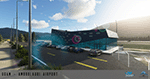
Ambrolauri Ambrolauri (Georgian: áƒáƒ›áƒ‘რáƒáƒšáƒáƒ£áƒ ი) is a city in Georgia, located in the western part of the country, on both banks of the Rioni river, at the elevation of 550 m above sea level. It is a self-governing city. At the same time, the city serves as the seat of the Racha-Lechkhumi and Kvemo Svaneti regional administration and the Ambrolauri Municipality. According to the 2014 census, the city had a population of 2,047. Its area is 1.6 km². Ambrolauri is first recorded in the 17th century as a place, where one of the palaces of the kings of Imereti was located. It acquired the city status in 1966 and became a self-governing city with its own municipal government in 2014. The Airport The airport is nestled into the Caucasus mountains right at the bank of the river Rioni. It has a single runway of 1100 m length and caters small propeller aeroplanes. The apron has space for two planes at a time and caters up to 50 passengers at one time. In the Simulator The virtual airport is very close to its real-world counterpart. All the buildings at and near the airport are modelled and the terminal even has an interior that can be seen from outside. The look and feel from a trip to the Racha region is definitely there. In real life, only small planes fly to the airport but that shouldn't stop you to bring planes from the size of the Dash 8.
| Filename: | UGAM_Ambrolauri_Airport_Georgia_MSFS.zip |
| License: | Freeware, limited distribution |
| Added: | 30th December 2020, 18:16:07 |
| Downloads: | 179 |
| Author: | David Hilker |
| Size: | 72.32 MB |
© 2001-2026 AVSIM Online
All Rights Reserved
Privacy Policy |