
Where Flight Simulation Enthusiasts Gather from Around the World!
AVSIM Library - Search Results

| Category: Flight Simulator 2004 - Scenery | |
| Lac des Plages grass strip in Quebec Canada |

|
Images related to this file:
File Description:
Lac des Plages is in Quebec on the north shore of the lake (and village) of the same name, some 55 miles northeast of Ottawa. It is an old grass strip and next to a tourist trailer park ("caravan" to the English). The runway is almost north-south and 2,200 feet long, and I went there to see if it is still in use. It is in good condition but there was nobody to ask (in early April) if it is still used and nobody turned up see if a plane had landed. I doubt if it is used regularly as there are no "wear" marks that show up on a grass strip, and the flare pots (actually old wheel rims with charcoal in them?) beside the runway could have been lit three months ago or three years ago, there was no way to tell. The single hangar is obviously no longer in use as a hangar, and the lack of a fence between the trailers and the grass strip would be a danger to pilot and strolling pedestrian alike. However, the runway still exists and here it is and as in real life the northern end slopes unevenly up.
| Filename: | Lac_des_Plages_grass_strip_in_Quebec_Canada.zip |
| License: | Freeware, limited distribution |
| Added: | 10th May 2010, 16:03:42 |
| Downloads: | 284 |
| Author: | Roger Wensley |
| Size: | 1.33 MB |
| Category: Flight Simulator 2004 - Scenery | |
| PAHT - Amchitka - Aleutians, Alaska - USA |
|
Images related to this file:
File Description:
Amchitka is near the western end of the Aleutian chain of islands in Alaska, around 180 miles west of Adak, and was not included in FS9. There is no small town on Amchitka Island, which is why it was used for atom bomb testing after being closed down as an Air Force base. There are three runways from the 1940's, the largest of which is aligned 07-25 and just over 10,000 feet of overgrown asphalt 300 feet wide. The second runway is aligned 15-33 and 6,000 feet (also 300 feet wide) and the third is 05-23 and 5,000 feet. The whole eastern end of the island is crowded with old munitions storage areas and other military paraphernalia, including old quonset huts; some of those are included here. There are also some old buildings still standing but on their way to becoming piles of old wood or rust, and some of these are included. There is almost no visual information available about Amchitka; even Google Earth has snow obscuring what buildings still exist and where they are, so much of this is at best only approximate apart from the two large hangars. There are no markings, lights, signage, or a control tower.
| Filename: | PAHT__Amchitka__Aleutians_Alaska__USA.zip |
| License: | Freeware, limited distribution |
| Added: | 6th February 2015, 00:06:26 |
| Downloads: | 269 |
| Author: | Roger Wensley |
| Size: | 2.6 MB |
| Category: Flight Simulator X - Aircraft Repaints, Textures and Modifications | |
| "Fantasy of Flight" AT-6 Texan (N3931Y) |
|
Images related to this file:
File Description:
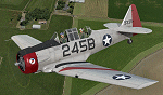
This is a repaint for the payware A2A Simulations AT-6 Texan. This repaint depicts AT-6D/AT-6G 49-3311, registered as N3931Y, which is owned/operated by Kermit Weeks at "Fantasy of Flight" in Polk City, FL. This aircraft was originally manufactured as an AT-6D in WWII for the USAAF, but was rebuilt to AT-6G standard in 1949 for the USAF. The aircraft served in the Spanish AF as a "Caza 6", C.6-167, from around 1962 all the way until 1982, serving as both a trainer and a frontline ground support aircraft, with machine guns mounted in the wings and rocket launchers under the wings. Imported into the US in the 80's, and flying on the civil register, the aircraft is painted as a tribute to the Women Airforce Service Pilots (WASP), with the markings of Avenger Field in Sweetwater, Texas, where they trained. The WASP insignia "Fifinella" is applied to the cowling, which was designed by Disney during the war. This aircraft is one of those which have been covered by Kermit Weeks in his popular "Kermie Cam" flight video series on Youtube. The repaint was created using the A2A product paintkit.
| Filename: | Fantasy_of_Flight_AT6_Texan_N3931Y.zip |
| License: | Freeware |
| Added: | 2nd April 2016, 11:43:15 |
| Downloads: | 266 |
| Author: | John Terrell |
| Size: | 33.24 MB |
| Category: Flight Simulator 2002 - Scenery | |
| Mikonos and Ikaria Island Airports |
|
File Description:
FS2002 Mikonos LGMK and Ikaria LGIK of the Aegean sea in Greece. Two typical summer holiday destinations in Hellas. The scenery represents Mikonos and Ikaria Island Regional Airports. Several objects like trucks, houses, stones, fences, and proper photorealistic textures have been used to make this airport as real as it gets and help the scale perception of the pilot. Special care has been taken for night lighting. Ikaria, a mountainous, thickly forested island, perpetuates the myth of Ikarus and his fall into the sea near its south shores after his bold attempt to reach the sun with his waxen wings. Mikonos in the center of Aegean sea, has been one of the best keeper of traditional Aegean architecture and is well known for it's popular golden sandy beaches and ecstatic nightlife. It is called "The island of winds" and indeed it is. Most frequent North winds have no physical barrier, all the way from Northern Greece, to weaken them and the constant seabed from there helps the increase of wind's speed by the time it reaches Mikonos. Beware of steep rising terrain and the wind gusts and downdrafts on short finals. Use this scenery preferably tohether with the free Greek Mesh Scenery by Babis Perivolas.
| Filename: | Mikonos_and_Ikaria_Island_Airports.zip |
| License: | Freeware |
| Added: | 12th November 2002, 19:49:45 |
| Downloads: | 6,075 |
| Author: | Vangelis Generalis |
| Size: | 2.93 MB |
| Category: Flight Simulator 2002 - Scenery Design | |
| BusyObjects v1.0 |
|
File Description: BusyObjects Version 1.0
The BusyObjects framework is a tool for scenery designers that want to add animated objects to sceneries without having to use dynamic sceneries. It can be used to animate ground vehicles, ships, planes and all other kind of moving objects.
BusyObjects is a technology that exploits a new way of animating objects in static FS2k+ sceneries. It allows you to play animations at varying speeds, begin (and end) animations at any time and have complex path definitions for the animated object. Since the object is rendered at different positions for every frame, the object transformation appears very smooth.
This work is freeware and MUST NOT be used as part of any commercial products without written permission of the author. Results produced with this work contain code and data that are part of the work; therefore results have the same restrictions as the original work and MUST NOT be used as part of commercial products without permission.
For more information visit http://www.brainon.ch/area51/brf/BusyObjects.
Copyright © 2003, Bernd R. Fix. All Rights Reserved.
| Filename: | BusyObjects_v10.zip |
| License: | Freeware, limited distribution |
| Added: | 19th March 2003, 01:37:25 |
| Downloads: | 2,510 |
| Author: | Bernd R. Fix |
| Size: | 420.03 KB |
| Category: Orbiter - Spaceships | |
| Minuteman II Missile |
|
File Description:
The Minuteman was Americas Third Operational ICBM System. During the Cuban Missile Crisis it was America's "Ace In The Hole". It has been operational at U.S. bases since 1962 reaching a peak of 1,000 missiles.
The Minuteman II program was economically crucial to the development of integrated circuits. It was the first mass-produced system to use a computer constructed from integrated circuits, and used most of the production of such circuits from 1962 through 1967. The other major customer of these circuits was the Apollo Guidance Computer, which had similar weight and ruggedness constraints.
The Orbiter version keeps up with the historical aspect of this horrible weapon. This add-on is created for historical purposes only, and we do not condone using Orbiter to simulate nuclear war. No active Minuteman II missiles currently exist today. The only way to see one now is at a museum or on display at various Air Force bases world wide. This add-on simulates the flight plan and package delivery of a real Minuteman II missile.
The warhead included in this add-on is from the Trinity package created by Dave Rowbothham. The warhead activates at about 4 minutes to impact. It arms at 2000 feet and detonation occurs at 1800 feet.
| Filename: | Minuteman_II_Missile.zip |
| License: | Freeware |
| Added: | 27th September 2004, 16:24:26 |
| Downloads: | 1,380 |
| Author: | Jim Williams |
| Size: | 1.12 MB |
| Category: Flight Simulator X - Flight Plans | |
| Gunateeta Air Shuttle |
|
File Description:
Gunateeta Air Shuttle is owned by Ingur Sing, an old pilot who flew for many years as co-pilot for India Airways.
One day he desided to quit the airline and open his own business with an Auster which he bought for 70,000 Rupies
of that time. He flew passengers and cargo to many towns with just a grass strip near Bombay, for about 10 years. He now
now owns two DH 104 Doves and since he is too old to fly them he hires pilots that have the needed credentials
who fly his planes to small towns that now have a small airfield but are way out in some rugged areas.
The regular flight is that which leaves Bombay late in the afternoon, around 4:45PM and flies on to Kurpikang,
Majuri, Churpikur and finally stops in ::::::::: where the last passengers disembarc. Here the plane is loaded
with flowers and rubber plants that must be flown to Bombay where they will be transfered to the late night Flight
to N.Y. by Air India...the flowers must be next day in "Bulby Sing" flower shop in Manhattan---that´s Ingur´s
sister business in America.....
So, Piloto you have the flight this evening...get over
| Filename: | Gunateeta_Air_Shuttle.zip |
| License: | Freeware, limited distribution |
| Added: | 31st March 2009, 20:54:53 |
| Downloads: | 313 |
| Author: | Gera Godoy Canova |
| Size: | 5.51 MB |
| Category: Flight Simulator 2004 - Scenery | |
| Montana Unleashed! - Part One |
|
Images related to this file:
File Description:
Montana Unleashed! Part 1 is the first in a two part series of a collection of airports in Montana. The majority of airports covered in Part 1 are located in the western half of the state. THIS IS A RE-UPLOAD OF A PREVIOUS UPLOADED SCENERY THAT WAS LOST DURING THE AVSIM HACK! NOTHING HAS CHANGED!
Montana Unleashed! is a collection of 14 highly detailed airports, created using Abacus' EZ-Scenery, scattered about the state of Montana and one in Washington. Do a ZipDive and check out some of the screenshots! The state of Montana, from what I've seen, seems to have been very neglected by scenery makers over the years which is surprising considering the beautiful and varied landscapes the state has to offer. There's some very cool approaches at many of these airports. The size of the airports vary from large all the way down to small county airports meaning you can fly just about any kind and size of aircraft with these sceneries. Fly your Delta 737 from Salt Lake to Bozeman. Fly your shiny new Skywest EMB-120 from Missoula to Billings. Or fly your Piper Cub from Havre City to Choteau and on to Dillon. It's all here!
| Filename: | Montana_Unleashed__Part_One.zip |
| License: | Freeware, limited distribution |
| Added: | 18th April 2010, 09:48:54 |
| Downloads: | 7,074 |
| Author: | Lauren Robison |
| Size: | 3.81 MB |
| Category: Flight Simulator 2004 - Aircraft Repaints, Textures and Modifications | |
| Flight dynamics update V1.0 for FS2004 Boeing KC-135R Stratotanker By Mike Stone |
|
File Description:
Flight dynamics update V1.0 for FS2004 Boeing KC-135R Stratotanker By Mike Stone
Dynamics only, Original aircraft available at:
http://www.pmstone.com/
Note: both these dynamics AND the real plane do NOT have thrust reversers. It seems the USAF did not want them on their plane, despite the availability on that engine model. Anyway, don't use the thrust reverse.
A friend who's recently posted to a KC-135 squadron recently asked me to tweek the layout of the fuel tanks on Mike Stone's freeware KC-135. What I thought would be a very simple edit ended up being a full blown project that transformed how the model flies, and what kinds of payload configurations are possible.
For instance, the KC can carry either internal fuel bladders in the main cargo bay, along with full wing and fuselage fuel, or it can take reduced fuel load and take on a fair amount of cargo pallets. My edits will allow you to choose one or the other, but it's defaulting to a air refueling mission that it sees more commonly.
Once on my way, I requested and received permission from Mike Stone to share this edited dynamics, which I'm doing right now. Enjoy!
| Filename: | Flight_dynamics_update_V10_for_FS2004_Boeing_KC135.zip |
| License: | Freeware |
| Added: | 11th December 2005, 19:08:54 |
| Downloads: | 813 |
| Author: | Rick Deckard, Mike Stone (original Aircraft) |
| Size: | 117.56 KB |
| Category: Flight Simulator 2004 - Utilities | |
| Active Camera 2004 Version 1.1 |
|
File Description:
(Shareware, non time limited and fully functional - limited to the Seattle area). FS2004 Active Camera 2004. This version replaces Active Camera 2004 1.0 (ac2004.zip). With this module you can enable additional views in Microsoft Flight Simulator 2004 - A Century of Flight. Several new camera views are selectable from the FS2004 - Options menu. When activated this module replaces the original tower and virtual cockpit views of FS2004. Features: Fly by, approach and spotter view, mouse driven spot plane view, allows mouse panning, zooming and clicking, discover spectacular effects like head latency, pre-stall buffeting, ground turbulence, thanks to FS2004 interactive virtual cockpits it is easy to move the mouse, pan and click, so allowing a more realistic way of flying, the virtual pilot can walk in the cabin (ability to create passenger and wing views) and outside of the aircraft, ability to save and call up to 10 views presets per aircraft, either in the VC or in external view, and this for an unlimited number of aircraft, ambient sounds like steps, wind and aircraft stress sounds, main features can be called through keyboard shortcuts, built-in TCAS that allows AI traffic tracking view (dynamic padlock like in combat simulators).
| Filename: | Active_Camera_2004_Version_11.zip |
| License: | Commercial demo |
| Added: | 1st October 2003, 15:22:54 |
| Downloads: | 40,036 |
| Author: | Serge Baye, Guillaume Darier |
| Size: | 3.17 MB |


© 2001-2026 AVSIM Online
All Rights Reserved
Privacy Policy |