
Where Flight Simulation Enthusiasts Gather from Around the World!
AVSIM Library - Search Results

| Category: Flight Simulator 2004 - Scenery | |
| Project Mexico Real LOD10 File 10 of 11 |

|
Images related to this file:
File Description:
Re-upload. File 10th of 11 of a Terrain Mesh that covers the entirety of Mexican Territory and related bordering U.S., Guatemala and Belice areas, part of the "Proyecto Mexico Real" project, compiled at LOD10 (1.24 arcseconds in latitude and 1.65 arcseconds in longitude) resolution from INEGI data. Intended to enhance the virtual flying experience complementing the LOD8 and LOD9 versions compiled from the same data. Compatible backwards with Flight Simulator 2000, Flight Simulator 2002 and Combat Flight Simulator 2. Refer to the file contents about the cover area to this compressed file.
| Filename: | Project_Mexico_Real_LOD10_File_10_of_11.zip |
| License: | Check within download |
| Added: | 5th September 2010, 20:55:05 |
| Downloads: | 3,062 |
| Author: | Juan Jose Galvan Bautista |
| Size: | 70.54 MB |
| Category: Flight Simulator 2004 - Scenery | |
| Project Mexico Real LOD10 File 3 of 11 |
|
Images related to this file:
File Description:
Re-upload. File 3rd of 11 of a Terrain Mesh that covers the entirety of Mexican Territory and related bordering U.S., Guatemala and Belice areas, part of the "Proyecto Mexico Real" project, compiled at LOD10 (1.24 arcseconds in latitude and 1.65 arcseconds in longitude) resolution from INEGI data. Intended to enhance the virtual flying experience complementing the LOD8 and LOD9 versions compiled from the same data. Compatible backwards with Flight Simulator 2000, Flight Simulator 2002 and Combat Flight Simulator 2. Refer to the file contents about the cover area to this compressed file.
| Filename: | Project_Mexico_Real_LOD10_File_3_of_11.zip |
| License: | Check within download |
| Added: | 8th June 2010, 03:17:03 |
| Downloads: | 3,255 |
| Author: | Juan Jose Galvan Bautista |
| Size: | 73.67 MB |
| Category: Flight Simulator 2004 - Scenery | |
| Project México Real LOD10 File 4 of 11 |
|
File Description:
File 4th of 11 of a Terrain Mesh that covers the entire Mexican Territory and related areas bordering the U.S., Guatemala and Belice areas. Part of the "Proyecto México Real" project, compiled at LOD10 (1.24 arcseconds in latitude and 1.65 arcseconds in longitude) resolution from INEGI data. Intended to enhance the virtual flying experience complementing the LOD8 and LOD9 versions compiled from the same data. Compatible backwards with Flight Simulator 2000, Flight Simulator 2002 and Combat Flight Simulator 2. Refer to the file contents about the cover area to this compressed file.
| Filename: | Project_Mxico_Real_LOD10_File_4_of_11.zip |
| License: | Check within download |
| Added: | 6th June 2006, 00:58:59 |
| Downloads: | 3,067 |
| Author: | Juan José Galván Bautista |
| Size: | 74.49 MB |
| Category: Flight Simulator 2004 - Scenery | |
| Project México Real LOD10 File 6 of 11 |
|
File Description:
File 6th of 11 of a Terrain Mesh that covers the entire Mexican Territory and related areas bordering the U.S., Guatemala and Belice areas. Part of the "Proyecto México Real" project, compiled at LOD10 (1.24 arcseconds in latitude and 1.65 arcseconds in longitude) resolution from INEGI data. Intended to enhance the virtual flying experience complementing the LOD8 and LOD9 versions compiled from the same data. Compatible backwards with Flight Simulator 2000, Flight Simulator 2002 and Combat Flight Simulator 2. Refer to the file contents about the cover area to this compressed file.
| Filename: | Project_Mxico_Real_LOD10_File_6_of_11.zip |
| License: | Check within download |
| Added: | 6th June 2006, 01:07:16 |
| Downloads: | 3,024 |
| Author: | Juan José Galván Bautista |
| Size: | 71.63 MB |
| Category: Flight Simulator 2004 - Scenery | |
| Project México Real LOD10 File 11 of 11 |
|
File Description:
File 11th of 11 of a Terrain Mesh that covers the entirety of Mexican Territory and related bordering U.S., Guatemala and Belice areas, part of the "Proyecto México Real" project, compiled at LOD10 (1.24 arcseconds in latitude and 1.65 arcseconds in longitude) resolution from INEGI data. Intended to enhance the virtual flying experience complementing the LOD8 and LOD9 versions compiled from the same data. Compatible backwards with Flight Simulator 2000, Flight Simulator 2002 and Combat Flight Simulator 2. Refer to the file contents about the cover area to this compressed file.
| Filename: | Project_Mxico_Real_LOD10_File_11_of_11.zip |
| License: | Check within download |
| Added: | 6th June 2006, 01:52:33 |
| Downloads: | 3,098 |
| Author: | Juan José Galván Bautista |
| Size: | 69.98 MB |
| Category: Prepar3D V1-4 - Scenery | |
| P3D v4.3 Aeropuerto Internacional Alejandro Velasco Astete-PERU |
|
Images related to this file:
File Description:
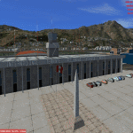
ONLY FOR P3D V4.3
REQUIRES ANY TERRAIN MESH
Alejandro Velasco Astete International Airport (IATA: CUZ, ICAO: SPZO) is an international airport located in the city of Cusco, in southeastern Peru. Cusco, a principal tourist attraction in Latin America, receives various domestic flights as well as some international flights. The runway is completely paved. It operates at limited capacity due to its precarious location near the city's center. Despite these limitations, the airport has consistently ranked as Peru's second most important air terminal, handling 3,209,153 national and international passengers in 2016, as reported by CORPAC.
| Filename: | P3D_v43_Aeropuerto_Internacional_Alejandro_Velasco.zip |
| License: | Freeware |
| Added: | 15th June 2019, 22:52:35 |
| Downloads: | 1,748 |
| Author: | Jhon Cristian |
| Size: | 115.91 MB |
| Category: Flight Simulator X - Scenery | |
| Falklands_2007 ** REPOST ** |
|
File Description:
Welcome to Falklands 2007 for Flight Simulator X.
This scenery has been released to commemorate the liberation of the Falkland Islands 25 years ago.
The scenery replaces the default mesh, landclass, coastlines and models with completely new and hand built components.
There are 325 ponds, not including the Black Tarn and Colorado ponds; my apologies if I have inadvertently missed out your favourite fishing hole!
There are 40 rivers.
There are 42 road segments.
There are 89 beaches.
There are 240 separate islands (not including the East and West Falklands themselves).
| Filename: | Falklands_2007__REPOST_.zip |
| License: | Freeware |
| Added: | 2nd June 2016, 15:40:58 |
| Downloads: | 1,920 |
| Author: | Brian Jamieson |
| Size: | 10.06 MB |
| Category: Flight Simulator 2004 - Scenery | |
| Cuba Archipelago: Cayo Largo and Cayo Coco trees |
|
Images related to this file:
File Description:
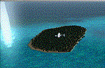
Dear Friends simmer of eternal fs 2004, with this job i want to i wanted as much as possible, increment the realism of default scenery of Cayo Largo and Cayo Coco fs 2004 using bgl of 'friend Gianluca Giovannini. I suggest to use some Cuba mesh freeware or payware. Down the lane I also Needless to say, the effect with the scenery taxi2gate (payware) is really better, but you can find a good scenery in the web.
Happy Flights and greetings from Italy, Fabio "fafoair" ferrari, Castione Presolana Bergamo.
| Filename: | Cuba_Archipelago_Cayo_Largo_and_Cayo_Coco_trees.zip |
| License: | Freeware, limited distribution |
| Added: | 14th March 2013, 04:12:34 |
| Downloads: | 911 |
| Author: | Fabio Ferrari "fafo air" |
| Size: | 4.94 MB |
| Category: Flight Simulator 2004 - Scenery | |
| Reservoirs and Lakes of Lesotho and Western Natal, South Africa |
|
File Description:
Replacement files for water bodies of eastern South Africa, in and near the Drakensberg Range (S28.1-29.5 E28.3-30.0). Natural and man-made lakes are now in their accurate position and elevation. Includes the Katse Dam reservoir in Lesotho as well as about 100 smaller lakes in Lesotho and western Natal not present in the FS default scenery. Based on a watermask derived from Landsat 7 ETM+ satellite data and compiled with a beta version of Jim Keir's "Slartibartfast" utility. Meant to be used with the Aeroworx SRTM LOD9 South Africa mesh.
| Filename: | Reservoirs_and_Lakes_of_Lesotho_and_Western_Natal_.zip |
| License: | Freeware, limited distribution |
| Added: | 8th May 2004, 02:43:38 |
| Downloads: | 6,206 |
| Author: | Holger Sandmann, Aeroworx |
| Size: | 464.27 KB |
| Category: Flight Simulator 2004 - AI Flight Plans | |
| Aero Tropics AI package Supplement |
|
File Description:
AERO TROPICS AI PACKAGE - SUPPLEMENT
This package is a supplement to "aerotropics.zip" (REQUIRED) posted on 7th August 2004
A new AFCAD for Darnley Island (YDNI) is included. This is only required if using the Australia STRM mesh by Andy Weir. If you are using default scenery, DO NOT use this AFCAD.
My apologies for omitting the airport list from the previous package. They are now listed here.
The IATA code "NLF" mysteriously crept into the previous flightplan. That has been replaced by the correct ICAO code of "YDNI".
| Filename: | Aero_Tropics_AI_package_Supplement.zip |
| License: | Freeware, limited distribution |
| Added: | 11th August 2004, 17:53:40 |
| Downloads: | 642 |
| Author: | Mal Lloyd |
| Size: | 6.87 KB |


© 2001-2026 AVSIM Online
All Rights Reserved
Privacy Policy |