
Where Flight Simulation Enthusiasts Gather from Around the World!
AVSIM Library - Search Results

| Category: Flight Simulator X - Scenery | |
| "Your Own Sea Port"..Part II of "Your Own" |

|
File Description:
This scenery is Part II of "Your Own" Series. The first one is "Your own AirPort"....
slowly but surely a community is being born!!!!!!...what do you get with YOSP??
--
"YO Airport" has contracted the " Marching Band and Construction Ltd" to construct the " YO-Seaport" near the rich Oil Fields of the coast. MBC Ltd, has thus proceeded full blast on this major important Sea Port which will give traffic to YO Airport and sorroundings.....Now planes will fly on rigid schedules between these two airfields......
later YO-Hill Airfields(Part III) will come along in the mountains in small lakes and Sea Stops...or small seaplane destinations....for more Fun and activities!!!!
What does "Your Own Sea Port" has for you.....?and what can you do there??
1) Two Airfields, one grass for small private planes and one Concrete for Commercial traffic ( new technique so it won´t be "sunk" with whatever mesh you have!!!) ...........+ Floatplane Base!!!
2) Helicopter Pad at the Port Hospital...(lighted)
3) Rescue Sailors at burning ship!!!!---(ship sinking fast!!)...take them to the Port´s Hospital.
4) Check moving traffic with any chopper.( There is a red corvette which must be checked with some women driving too fast!!!)
5) Participate in:
Road Race ( Need a car!!)...Prices galore!!!
Boat Race around Red Bull Pylons (need a Boat!!)...RedBull guys left them here for good!!!
Fly a Race at the same Pylons...(Really Hard!!!!)
6) Fly Tourists to Fishing Lake where Bass Abounds..(Need Floatplane).
8) Fly with your Navy Patrol plane and check on some "Strange Submarine
taking pictures of the port"...if necessary blow it to smitherins!!!!!!!
9) Open a New Airline....YO Air Service Inc...
10) Fly around and take pictures.
11) Take executives to the Oil Facilities in the Interior (EpisodeIII)...
or just fly around with your gal, wife or hummmm, hummmm.............or go fly under its three bridges!!!!!
12) Take passenger from the "Float Plane" Airpark, near the hospital, to lakes and rivers. The Mayor of YOSP will be giving the "city Keys" to all Pilots
who makes four consecutive loops in a helicopter on Sunday at 11:42:45.
| Filename: | Your_Own_Sea_PortPart_II_of_Your_Own.zip |
| License: | Freeware, limited distribution |
| Added: | 28th November 2008, 15:48:14 |
| Downloads: | 1,513 |
| Author: | Gera Godoy Canova |
| Size: | 900.13 KB |
| Category: Flight Simulator 2004 - Scenery | |
| Cordova Smith PACV & Municipal CKU in Alaska US |
|
Images related to this file:
File Description:
Cordova is on the south coast of Alaska, around 150 miles east of Anchorage and 45 miles south of Valdez. The town is mainly built on a small but relatively flat area between the east side of Prince William Sound and Eyak Lake, and has a population of around 2,350 in 2010, the approximate date of this scenery.
The Municipal Airfield CKU is on the north side of Eyak Lake to the east of Cordova, with the runway that is 1,800 feet of unlit gravel squeezed between the lake and the road that runs around the lake. The hangars and parking aprons are reached by taxiing across, and to some extent along, the road. Float planes are also taken from the lake to an apron to the west of the runway.
Cordova Airport PACV (named in the real world "Merle K. (Mudhole) Smith", and I will leave you to research this) is known as Cordova Smith in FS9 and is 10 miles to the east of the town on relatively flat ground between mountains to the north and the sea to the south. The runway is 8,080 feet of lit asphalt aligned 09-27 with ILS on runway 27 and VASI on both ends. The aprons are to the north side of the runway and are reached by back-taxiing; there are no taxiways parallel to the runway. The main apron serves Alaska Air via the western of two taxiways. The GA parking and hangars are mainly reached by using the eastern taxiway, though there is in fact a connecting taxiway between the two (for GA, but definitely not for airliner use). The taxiway further to the west serves the separated Alaska Coastguard apron and hangar, which is mainly for helicopter use. There is a nominally grass runway 1,900 feet long and aligned 16-34 to the south of the main runway; in fact it appears to be more gravel than grass. I have left this inactive as otherwise AI Alaska Air planes would be attempting to use this when the wind made it seem like a good idea.
The AI includes Alaska Air (twice a day) and also Coastguard helicopters, along with GA.
| Filename: | Cordova_Smith_PACV__Municipal_CKU_in_Alaska_US.zip |
| License: | Freeware, limited distribution |
| Added: | 22nd January 2022, 21:53:03 |
| Downloads: | 145 |
| Author: | Roger Wensley |
| Size: | 16.93 MB |
| Category: Flight Simulator 2004 - Scenery | |
| Victoria, Canada area scenery |
|
File Description:
This is a complete upgrade of vicenh05, Victoria, Canada area scenery for FS9. New in this version: automated installer and configurator from Ken Peters; several detailed models including the Empress Hotel, the Legislature, the Regent Hotel and the Johnson St. Bridge; greatly enhanced Inner Harbour; many generic buildings representing buildings throughout the area; 7 new small airfields with sloping runways; seven new floatplane bases (owners of Vancouver+ get extensive floatplane traffic in local liveries); 7 new heliports (Vancouver+ users get additional heli AI traffic) and a myriad of minor fixes and improvements. Included from previous versions are revised shorelines, landclass and 19m mesh and buffer meshes for South-Eastern Vancouver Island; boat docks with static boats, seaplane docks and terminal buildings for Harbour Air, Kenmore Air and West Coast Air; piers, buildings, breakwater and other components of the Ogden Point Terminal; dock, service building and pilot boats of the Pacific Pilotage Authority; Odgen Point Cafe and Dive Shop; marine navigational lights for Victoria Harbour and area, including Esquimalt harbour and Oak Bay; antennae location corrections for the area; AFCADs included: Land based (CML2), Floatplane (CAB3, CAP5, CAP8, CAV8, CAW7, CAX6, CMAP, CYWH), Heli (CAL7, CBF5, CBF7, CBK8, CBW7, CBW9, CBZ7, CMBH); AI craft models and repaints (Cruise ships are repaints of Asuka model by Mitsuya Hamaguchi: MS Amsterdam of the Holland America Line travelling from Victoria to Vancouver, MS Summit of the Celebrity Cruise Line travelling from Seattle to Victoria); S-61 Sea-King helicopter in Helijet colours; Pacific Pilot custom vessel working from the Pilot dock; 22, 30 and 40 foot vessels plying the harbour and nearby Straight of Juan de Fuca. Effects included for lights, water, smoke effects. Many flights are offered, including two flights for owners of the Aerosoft Beaver (not required). Ultimate Terrain compatible (not required). Users of Misty Fjords will also get additional cruise ship traffic: the Island Princess and the Volendam alternating with the Amsterdam and Summit. Fully compatible with Don Grovestine's excellent CYYJ 2007. Replaces viflat.zip, ve4_tr1.zip, vicenh02.zip, vicenh03.zip, vicenh04.zip and vicenh05.zip. Detailed documentation included. By Jon Patch and Holger Sandmann.
| Filename: | Victoria_Canada_area_scenery.zip |
| License: | Check within download |
| Added: | 29th January 2010, 21:22:09 |
| Downloads: | 5,313 |
| Author: | Jon Patch and Holger Sandmann |
| Size: | 24.28 MB |
| Category: Flight Simulator X - Scenery | |
| Pagasa Island, Philippines |
|
Images related to this file:
File Description:
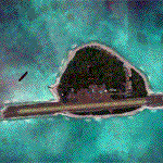
Pagasa Island is a jewel in the South China Sea. It is the one pictured - an emerald splash in an azure sea slashed by a coral runway - whenever new collisions or confrontations are reported in the news for the region. Occupied continuously by the Philippines since 1971, historical use dates back to the Han dynasty, which many believe forms the basis of the Chinese claim to the island. Each country has it's own interpretation of international law and the Filipinos are clearly banking on the precedence of continuous occupation, at no small expense, as Rancudo Field is the farthest airport from Manila within the Philippine sphere of control.
Surprisingly, the geography of the island serves to capture and retain rainwater, although the aquifer is stagnant and the water must be treated for consumption. Sea life remains abundant, poachers take coral heads and sea turtles. There is a solar farm and recently installed solar street lights, fuel for the generators is a precious commodity this far from the mainland.
Sadly, nature may solve the struggle for possession by withdrawing the island from the arena. It is believed that the construction of the runway may have compromised the islands basic integrity, allowing it to crumble into the sea. Whatever the cause, the evidence is clear. Bunkers built during the Japanese occupation in WWII are already slipping beneath the waves and the rate of salt water encroachment has been recorded at close to 6" per day.
There are some things to explore, the grounded BRP Laneo Del Norte to the west; over to the north near the resort grounds are a dugout fishing canoe and some authentic Philippine bangka boats; you may want to load up and head east to do some low warning passes over the Chinese fishing fleet. Standing at the east end of the field, you can just barely spot the China Coast Guard cutter's smoke on the horizon.
The tower is marked by a bright strobe that fires once every five seconds and at night it is bright enough to guide you back to the island from the distance of the fleet. There are no published procedures and the tower is not staffed. Airport ICAO is RPPN.
| Filename: | Pagasa_Island_Philippines.zip |
| License: | Freeware, limited distribution |
| Added: | 10th May 2014, 12:21:19 |
| Downloads: | 1,851 |
| Author: | Rick Keller |
| Size: | 16.17 MB |
| Category: Prepar3D V1-4 - Utilities | |
| FS Flight Builder |
|
Images related to this file:
File Description:

New version: Updated installer and auto-update functionality along with chart downloaded changes to support browser updated security measures.
FS Flight Builder is a utility for general aviation flying that will build flight files for FSX (flt), FSX Steam Edition (flt), and Prepar3D (fxml) based on waypoints and other data either entered manually or imported from SkyVector using the Plain Text Link information. Among other things, you can select your starting position, aircraft, and VFR or IFR flight plan.
One of the most interesting features of the application is that it will include a Briefing file, added to the aircraft's built-in kneedboard, that will include departure and destination airport information (runways, frequencies, weather, and charts) as well as navigation frequencies along the route.
Have you ever started up flight simulator and wondered “where do I want to go today� The new Destination Chooser functionality can help to solve that problem. The screen allows you to enter your departure airport and choose various parameters for your destination (like min and max distance, tower availability, ILS availability, runway length requirements, etc.).
How to install:
***************
Run Setup.exe and simply follow the installation wizard.
When you run the application for the first time (make sure your flight simulator is not running), it will build the database from your flight sim data. Be patient. It could take a few minutes.
It will attempt to locate your flight sim folder and flight plan folders automatically. If it can't find them, however, you'll need to select them from the options menu.
IMPORTANT!
Because FS Flight Builder saves to your Flight Sim directories, it MUST be run in Administrator mode. To do this, right-click on the desktop icon, select the Compatibility tab, and check the Run as administrator checkbox.
IMPORTANT!
The airport and navaid databases for FS Flight Builder are built using Peter Dowson's excellent Make Runway utility and the equally excellent BGL2XML utility from ScruffyDuck Software. The links to these utilities are below. They must be added to the main FSX or Prepar3D folder.
Peter Dowson's website: http://www.schiratti.com/dowson.html
ScruffyDick Software website: http://www.scruffyduck.org/bgl2xml/4584282773
It's also important to note that Version 1.7 of BGL2XML is required for Prepar3D V3 and higher.
Author:
*******
Tom Arduini
The latest installer can always be found at
http://www.arduiniwebdevelopment.com/fsflightbuilder/fsflightbuilder.zip
| Filename: | FS_Flight_Builder.zip |
| License: | Freeware |
| Added: | 24th December 2018, 02:41:36 |
| Downloads: | 408 |
| Author: | Tom Arduini |
| Size: | 69.56 MB |
| Category: Flight Simulator X - AFCAD Files | |
| Atlantic City International Airport (KACY), NJ |
|
File Description:
Located 09 miles NW of Atlantic City, New Jersey on 5000 acres of land, Atlantic City International Airport is a major airport serving the southern portion of New Jersey. It is also one of the main gateways for tourists looking to vacation in nearby Atlantic City, famous for its boardwalks and casinos. This airport has been very heavily modeled with many surrounding buildings and all aprons properly placed. Gates are all properly located and labeled according to the terminal chart (there are, however, no jetways like in the default scenery). General Aviation parking is available in its proper area � all aircraft in the parking area (middle of the tarmac) have collision disabled. If you select Military Cargo parking you will start on one of the helipads in the Coast Guard section. If you select Military Combat parking you will start next to the line of F-16s on ready-alert over on the Air National Guard tarmac. You can also start on a helipad north of the airport. This airport also features completely custom taxiway line and edge lighting. Because this airport uses ATC, it suffers the same bug as my KEWR airport, which is that you cannot receive taxi in directions from ATC � to gate, parking or fuel. Almost all arriving AI aircraft will also disappear from the taxiway after radioing in to ATC and failing to receive taxi instructions to the gate/parking. All traffic and instructions taxiing out works fine. All gate parking spaces have fuel, as well as the military parking and north helipad. GA aircraft can get fuel by taxiing over to the fuel station north of the GA tarmac. Taxiing onto a closed runway (marked with an �X�) will cause a crash. Broken-down taxiways are not good for your undercarriage!
Scenery constructed with use of satellite images/streetview/aerial photos - the author has not been there in person.
This scenery is meant to be used in conjunction with MegaScenery Earth New Jersey/Delaware 003. It is not required, but apron use is minimized to allow satellite scenery to show through as much as possible, and objects are placed based on the MSE textures - lack of it may make scenery look out of place.
| Filename: | Atlantic_City_International_Airport_KACY_NJ.zip |
| License: | Freeware |
| Added: | 1st February 2011, 10:28:53 |
| Downloads: | 1,355 |
| Author: | Drew Sikora |
| Size: | 5.12 MB |
| Category: Flight Simulator 2004 - Scenery | |
| PABR - Barrow - Alaska, USA |
|
Images related to this file:
File Description:
The town of Barrow is in the far north of Alaska, and is best known in flying circles as the place where Wiley Post crashed his floatplane on takeoff and killed himself and Will Rogers. The crash was some 15 miles south of Barrow and was "assisted" by the mismatched fuselage, wings, and floats that had been assembled to create the floatplane. The Barrow population is largely Inupiat and totals some 4,400. The downtown area of Barrow is immediately north of the airport. The second and largest part of Barrow is further north past a string of lagoons and is locally called Browerville. To the northeast along the coast is the smallest part around what used to be the Naval Arctic Research Lab, and is now a college. To the east of this are the DEW buildings, plus two large navy hangars and the gravel runway that was used to serve the DEW station. The PABR runway is aligned 06-24 in FS9 and is 7,100 feet long and 150 feet wide, built on top of a gravel base and surround that copes with the underlying permafrost. There is PAPI at both ends and an ILS and approach lights on 06; 06 circuits are to the right. The airport notes include a warning that the apron is not a standard width and that large planes that are enroute to the far end of the runway will not be able to taxi past a plane parked at the gate and should use the runway as a taxiway, then turn and takeoff. FS9 AI cannot cope with that, so the apron here is wider. There are, in real life and the AI, daily flights by Air Alaska (three at least) and Era (several, and which is now called Ravn, hence the new hangar door motif) and air cargo flights by Northern Air Cargo and Everts, plus GA. The buildings have been made with photographic textures or textures made from reference photos. I decided that while 500+ scenery objects was probably ok for most people the required 900+ to "make" the town of Barrow would likely not be. The auto-generated FS9 town objects could not be left as Barrow with trees would not look at all like reality; I have "faded" the density of the town buildings into the distance from the airport.
| Filename: | PABR__Barrow__Alaska_USA.zip |
| License: | Freeware, limited distribution |
| Added: | 17th May 2016, 09:32:36 |
| Downloads: | 971 |
| Author: | Roger Wensley |
| Size: | 15.12 MB |
| Category: Flight Simulator 2004 - Scenery | |
| VAGO Goa/Dabolim Navy, India |
|
File Description:
Googly scenery for Dabolim Navy Airport, Goa - a busy Indian military airport also used for
civilian flights which is poorly provided for in Flight Simulator 2004. These scenery
files add taxiways, aprons, buildings and other airport features, so that you and
your "AI" traffic can land, taxi, park and take off in a realistic manner.
Today Goa is a popular tourist destination, but it does not have its own civilian
airport. Instead the ever-increasing number of charter flights use the Indian
Navy's airport. But they may only land when the Navy's novice pilots are not
pretending the runway is a 11,000 foot aircraft carrier deck so civilian flights
have to be packed into short periods (before 9 am and 1 pm to 6 pm) and this leads
to the small terminal ramp being literally packed with aircraft at times. All kinds
of jets from around the world up to Boeing 747s call here, flown by European and
Asian operators like Air Deccan, Air India, Air Sahara, Arkefly, Condor Thomas Cook,
Go Air, Indian Airlines, Jet Airways, Kingfisher Airlines, Monarch Airlines,
Spicejet, SriLankan Airlines, Thomsonfly, Tiger Airways, Transaero and XL Airways
along with ATR turboprops on shorter flights with Air Deccan. The
Indian Coast Guard has a base here for its aircraft, and the Indian Air Force
carry out exercises from time to time with their fighter bombers. The Navy's
three-aircraft aerobatic team is also based here.
To cope with the increasing traffic, the airport is currently under development
and enlargement but details of this are not currently available so this scenery has
been created showing the existing arrangements. This, combined with the limitations
of Flight Simulator and its parking and taxying arrangements, means that it isn't
possible to realistically pack the aircraft all in at busy times. Any overflow of traffic will
find itself diverted to the Navy's parking area or even the aircraft museum.
However, my observations are that many of the schedules prepared for Flight
Simulator do not recognise the limited landing times and the traffic is spread
fairly evenly throughout the day, so such overflows should be infrequent.
The scenery does not purport to be ultra-accurate. Based on high-detail satellite
imagery from Google Earth, the layout is proportionally correct but the added
airport features, such as buildings, are built from default Microsoft objects
and add-on libraries so will not look like the real thing.
You are not obliged to download and install any additional scenery libraries,
but to enjoy this scenery in its entirety, you may wish to. It will work fine,
with or without.
| Filename: | VAGO_GoaDabolim_Navy_India.zip |
| License: | Freeware |
| Added: | 8th August 2007, 23:14:21 |
| Downloads: | 3,959 |
| Author: | John Hinson |
| Size: | 78.48 KB |
| Category: X-Plane - Original Aircraft | |
| Spruce Goose for X-Plane 6.4/6.51 (hk-1/H-4 Hercules) |
|
File Description:
Spruce Goose v1.0 for X-Plane copyright (c) by Robert App, January 2003. History of the "Goose" - Officially designated the HK-1 (this project started out as a join venture between Hughes Aircraft and Kaiser) and later designated the H-4 Hercules after Kaiser was unable to work with Howard. It was and still remains the largest (physical dimensions wingspan and length) aircraft ever built, with the largest radial engines ever built by the West (28 cylinder, 3000 HP). The plane had to be constructed mainly of wood due to the shortage of strategic metals caused by WWII. The plane became known as the "Spruce Goose" or "Flying Lumberyard" despite the fact that the wood frame and skin were constructed mainly of laminated poplar; it also involved "sandwich" construction. The plane was flown briefly on a trial taxiing run but Hughes never allowed the plane to be flown again. Speculation has always been rampant that the design was flawed and the plane could not have met the original specification requirements. The X-Plane model is as accurate as is possible with limited plans available to me. The main wing is an X-Plane standard symmetrical high lift airfoil as opposed to the high lift asymmetrical foil section used in the actual plane. The main wing angle of attack has been adjusted to emulate the asymmetrical foil as closely as possible.
Flight Testing the Goose - I have spent many hours testing the plane on X-Plane which with few exceptions provides a very accurate flight model. The published landing speed (79 mph) pretty well verifies the takeoff speed of 52 to 55 knots (k/hr x 1.15 (approx.) = mph). In straight flight the plane is difficult to stall since the nose quickly drops and increases speed if a stall develops with a significant loss of altitude. The plane has a range on 14000 gallons of fuel and takeoff weight of 350,000 Lbs of well over 3000 nautical miles. San Diego to Wake Island via Midway Attol is a piece of cake with lots of fuel to spare at 350,000 lb GW. The plane is flyable at a GW of over 410,000 lb but climb rate is very sluggish (max 400-600 fpm) and loss of speed due to excessive side slip can cause a fatal stall, in straight flight the plane is difficult to stall. So far my conclusion is that with todays materials and jet engines (which may be a future project) this aircraft could probably be competitive in performance with todays planes. With aluminum alloys that were available during its construction its performance would probably have exceeded the initial requirements.
| Filename: | Spruce_Goose_for_XPlane_64651_hk1H4_Hercules.zip |
| License: | Freeware, limited distribution |
| Added: | 31st January 2003, 05:19:19 |
| Downloads: | 1,739 |
| Author: | Robert App |
| Size: | 1.69 MB |
| Category: Flight Simulator 2004 - Scenery | |
| Sydney CYQY in Nova Scotia Canada |
|
Images related to this file:
File Description:
Sydney is a maritime port on the east coast of Canada, on the eastern corner of Cape Breton Island. It was founded in 1785 and grew in size emormously from 1900 as a steel mill was founded that prospered along with local coal mines until 1950 or so. After that date and following the final closure of the mill in 2001 the population declined to the current 29,000 or so. The airport is 3 or 4 miles southwest and inland of a coastal urban area which stretches from New Waterford in the north through Lingan, Dominion, Reserve Mines, and Glace Bay, to Port Caledonia, and 5 miles east of the town of Sydney which is beside a sheltered deep water harbour area. This version is not from a fixed date as although I had video of some of the buildings from 2010 I inadvertently constructed part of the apron layout from 2018 information, and then decided to keep it like that either because I liked it or perhaps was too lazy to redo it. The terminal building and the garages to the east of the terminal are original and old, though renovated and maintained to a fairly good standard. The other buildings on the airport are "hangars" in the expected form, with steel frames, insulated cladding, and pitched roofs. The airport publicises it's ability to cater for all the needs of visiting aircraft, with a large FBO hanger just beside the terminal. There are (or were, before the virus came along) scheduled flights by Westjet, Air Canada Jazz, and Air North, which are included in the AI along with GA flights. The runways are 07-25 at 7,000 feet and with PAPI on 25 and ILS on 07, and 01-19 at 6,000 feet with PAPI on 01 and ILS on 19. You will see once the scenery is installed that there are two folders in Sydney CYQY called "Scenery summer" and "scenery winter". Editing the folder name down from "scenery summer" to just "scenery" results in FS9 loading the summer ground textures and parked planes etc. In February you would edit down the "scenery winter" folder to just "scenery" and the unused and unswept taxiways, runway, and aprons will be invisible under the snow, the open-topped cars will not be parked in the open, and privately-owned planes will be in the hangars. If FS9 decides that there is snow on the ground then you need the winter textures, if not then the summer textures. The winter textures are not the full-snowdrift-middle-of-Winter-gale type and are more like early or late winter. One thing you must NOT DO is to edit both folders down at the same time.
| Filename: | Sydney_CYQY_in_Nova_Scotia_Canada.zip |
| License: | Freeware, limited distribution |
| Added: | 22nd August 2020, 00:07:58 |
| Downloads: | 274 |
| Author: | Roger Wensley |
| Size: | 29.42 MB |
© 2001-2026 AVSIM Online
All Rights Reserved
Privacy Policy |