
Where Flight Simulation Enthusiasts Gather from Around the World!
AVSIM Library - Search Results

| Category: Flight Simulator X - Aircraft Repaints, Textures and Modifications | |
| FSX/P3D Ethiopian Airlines 707-379C 1968 |

|
Images related to this file:
File Description:
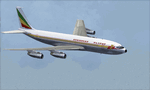
This is a repaint of the 707-379C in Ethiopian Airlines colors. The payware 707-300C by Captain Sim is needed for this repaint. Ethiopian Airlines was established in 1946 by the Emperor Haile Sellassie, and TWA which provided technical and managerial support. Regular operations commenced on April 8 1946 with a fleet of 6 ex USAAF DC-3s. Later in 1950, 2 Convair CV-240s entered the fleet. Then in 1958, the first DC-6B arrived on the scene. On January 1 1959 Ethiopian officially became a member of IATA. The first jet services started in 1963 after the delivery of the carrier's first Boeing 720s. The 720s replaced the DC-6Bs on the European routes. In 1964, Ethiopian started a new pilot training school, installed a large IBM computer system, and also established the largest jet overhaul facility in Africa. 707s, 727s, and 737s, joined the fleet in the ensuing years. Today Ethiopian ranks as Africa's supreme air carrier with a safe and reliable service, notwithstanding the 737 Max 8 tragedy, and has a vast route network. The cherry on top was when in 2014, Ethiopian dethroned South African Airways as the "Best African Airline". Textures are 32 bit dds and DXT5 textures are included as well. This repaint was tested FSX-SE. It should work on FSX & P3Dv1-3.
| Filename: | FSXP3D_Ethiopian_Airlines_707379C_1968.zip |
| License: | Freeware |
| Added: | 20th September 2019, 16:33:20 |
| Downloads: | 131 |
| Author: | Ted Giana |
| Size: | 20.14 MB |
| Category: Flight Simulator 2004 - Aircraft Repaints, Textures and Modifications | |
| Piaggio P-166 All Versions New Flight Dynamics + HTML Handbook Reference |
|
File Description:
Thanks to Andrew Spring of www.p166.com!!
This is a massive update for the Piaggio P-166 Series aircraft. This Package contains a whole update for ALL the models,(P-166A\M\S\BL2\CL2\DL3\DL3-SEM\DP1) and a pilot handbook in html format. You can read it in the full large version or in the reduced size version re-adapted for the electronic FS2004 kneeeboard as "Reference". All aircraft refer to the same file, so after the introdution to the P-166 and her main characteristics, individual links to the single P-166 versions are included (only "Kneeboard" version). The main improvements in the FDEs are a nice stability making the plane just fly strigght-and-leveled easily, re-calibrated flap and fuselage drags, wich makes for better max speed and landing characteristics. Also flaps and landing gear pitch moments are lots reduced. Now the plane respects the Specs of the real thing completly, even matching the changes from version to version!! in newer versions, engine power output has been recalculated, as well as new payloads and fuel capacities: you can litterally load the passangers and baggage you wish...but don't try to exaggerate, going overweight is not that complex...for instance, try placing a 9999 pounds copilot and guess what happens...
Happy Flights!!
| Filename: | Piaggio_P166_All_Versions_New_Flight_Dynamics__HTM.zip |
| License: | Freeware |
| Added: | 5th August 2004, 16:57:33 |
| Downloads: | 1,724 |
| Author: | Mario Noriega |
| Size: | 3.14 MB |
| Category: Flight Simulator 2004 - Scenery | |
| Stewart CZST and CAC9 in British Columbia Canada, plus Hyder 4Z7 in AK |
|
Images related to this file:
File Description:
Stewart is in northern British Columbia, around 115 miles north of Terrace, 70 miles northeast of the open sea, and 2 miles from the Canada/US border at the head of a fjord named the Portland Canal. Both Stewart and the nearby Hyder in AK thrived along with silver and gold mining in the early 1900's in the AK and BC interiors and in 1914 Stewart's population was over 10,000, but the current population is now less than 500. This scenery includes Stewart airport (CZST) and also Stewart floats (CAC9) plus Hyder floats 4Z7 which is within sight of Stewart but in Alaska. 4Z7 is based upon the three FSAddon freeware and payware Alaska sceneries, and without whichever one covers Hyder (I forget which) the float base will be isolated way offshore. The Stewart airport is adjacent to the town. There is a single runway that is unlit and just under 4,000 feet of asphalt aligned 18-36, with right hand circuits on 18; a brief view of the surrounding terrain makes it quite clear why. This version is for a period around 2010 to 2012 or so, before a second fuel tank was installed. There are no regularly scheduled flights to Stewart, only GA and charters, but the airport survives with the tourist trips. I have not forgotten the signage for CZST; there isn't any. There is also no clearly defined and fenced boundary to the airport, with a gravel apron beyond the asphalt that then fades to dirt and grass and a road. Hyder has no land connection to the rest of Alaska except through Stewart and a long road trip; the only direct link is by float plane to Ketchikan, 75 miles in a straight line. The AI includes this.
| Filename: | Stewart_CZST_and_CAC9_in_British_Columbia_Canada_p.zip |
| License: | Freeware, limited distribution |
| Added: | 18th January 2019, 18:08:29 |
| Downloads: | 172 |
| Author: | Roger Wensley |
| Size: | 8.9 MB |
| Category: Prepar3D V1-4 - Aircraft Repaints, Textures and Modifications | |
| Alaska Airlines "HONORING THOSE WHO SERVE" livery Operated by Horizon Air E175LR (N651QX) |
|
Images related to this file:
File Description:
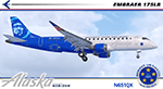
I am proud to present this very special Alaska Airlines Embraer E175LR, operated by Horizon Air, registration N651QX. This E175LR is the third "Honoring Those Who Serve" aircraft in the Alaska Airlines fleet which pays tribute to US military members, veterans, fallen soldiers and their families. Its unique exterior paint scheme, conceived by a small group of Alaska maintenance technicians, was designed to honor those who serve today, and those who served in the past. The design includes; A red stripe and blue aircraft body to incorporate elements of the American flag, the phrase "Honoring Those Who Serve," displayed on the fuselage, symbolic crests representing the Alaska Airlines Fallen Soldier Program on the starboard side rear cargo door and on the port side of the aircraft behind the aft service door, a "Horizon Air Salutes" medallion near the nose of the aircraft on both sides with the five stars, winglets in red, white and blue representing the flag of the United States and five gold stripes on the engine cowls representing the five branches of the U.S. Armed Forces. There is also a Sidney Sheldon quote next to the forward passenger entry door reading “My heroes are those that risk their lives to protect the world and make it a better place.â€
The repainted textures in this package are 32-bit with no mipmaps for best clarity and quality. All of the medallions are hand painted. This is the Version 3 model of the FeelThere Embraer 175. You must own a copy of the Feelthere E-JETS E175 and E195 V3 to enjoy this repaint.
A special thank you to all who serve, who have served and to those who gave their lives in service to this country.
| Filename: | Alaska_Airlines_HONORING_THOSE_WHO_SERVE_livery_Op.zip |
| License: | Freeware, limited distribution |
| Added: | 29th April 2020, 19:09:32 |
| Downloads: | 831 |
| Author: | Jeffrey S. Bryner, FeelThere |
| Size: | 56.71 MB |
| Category: Flight Simulator 2004 - Scenery | |
| Kaltag KAL in Alaska |
|
Images related to this file:
File Description:
Kaltag is a small village on the west bank of the Yukon River, around 65 miles east of the coast at Unalakleet and about 40 miles south of where the river turns from north-south to east-west, east being upstream towards the distant Fairbanks. The population is just under 200 and living from fishing and the land. The airfield is close by and has a gravel runway aligned 21-3 and just under 5,000 feet long. Apart from the airfield itself, and it's buildings, this scenery modifies the local land class, adds village buildings while reducing the village size to reality, and creates a new airfield background. Kaltag is located on the edge of three different airlines coverage areas, and is served by Bering Air from the northwest, ERA from the southwest, and also by Wright Air from Fairbanks in the east. These are included in the AI.
A note here about my scenery making. This is post number 507 and there will not be many more to follow this as I am almost at the end of the photos I either took or found for scenery purposes. There is a limit to what can be located online and I have already been making use of the little there is; eg Unalakleet. So, if you are near an airport (preferably Canadian or Alaskan) and have a camera..... Let me know.
| Filename: | Kaltag_KAL_in_Alaska.zip |
| License: | Freeware, limited distribution |
| Added: | 20th August 2019, 19:04:35 |
| Downloads: | 101 |
| Author: | Roger Wensley |
| Size: | 3.57 MB |
| Category: Flight Simulator X - Scenery | |
| YEEB Eneabba, Western Australia strip and townsite |
|
File Description:
YEEB Eneabba strip and townsite
Sand mining town in heart of wildflower area Located 278 km north from Perth via the Brand Highway, Eneabba is basically a sand mining town surrounded by some of the most extensive and spectacular wild flower displays anywhere in Western Australia. The town itself is, to be fair, a real non-event with dreary modern housing (with more than a hint of construction town design), a small shopping centre and a service station all of which look as though they have sprung up in the last 20-30 years. The wealth of the area is based on the rutile sands which lie to the south of the town as well as farming, particularly cattle grazing. With an estimated 80 per cent of the world's known rutile supplies the town can boast that it has the biggest deposits of rutile in both Australia and the world. The major mining company in the area is Iluka Resources Ltd. Eneabba is basically a service town for the mines but some of the miners, realising that Eneabba is hardly a paradise, have opted for commuting and live on the coast at Leeman and drive to work preferring the beach to the dry inland.
REQUIRES blencowe_librarykit_309494.zip (Available HERE)
| Filename: | YEEB_Eneabba_Western_Australia_strip_and_townsite.zip |
| License: | Freeware |
| Added: | 25th February 2013, 23:48:24 |
| Downloads: | 255 |
| Author: | Alan Blencowe |
| Size: | 3.59 MB |
| Category: Flight Simulator 2004 - Scenery | |
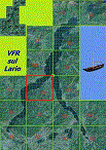
| VFR of Lario, Area C2A - Como lake, Italy |
|
Images related to this file:
File Description:
*** REPLACEMENT OF PREVIOUS ISSUE, due to a bug of an High Winter texture ***
This is the fifth scenery of the "VFR of Lario" project, made with photorealistic terrain (multiseason & night) and with some 3D GMax realistic objects.
Information: Como's lake is in the north of Italy, closed to the Helvetic border; this scenery covers approximately an area of 7.5x6 kmt, from la "Zoca de l'Oli" and mountains over Ossuccio (NW) to Tremezzo (NE), and from Colonno (SW) to Magreglio (SE) and includes the NLC piers of Sala Comacina, Comacina island, Campo, Lenno, Tremezzo, Bellagio (2), S. Giovanni, Lezzeno; it includes several dedicated buildings as Taverna Bleu hotel (Sala Comacina), S. Maria e S.Giacomo churches and villa Balbiano (Ossuccio), church and pier of S. Michele (Colonno), villa del Balbianello (Lenno), hotel Villa Marie, S. Lorenzo Church, villa La Quiete, Grand Hotel, villa Carlotta, hotel La Darsena, Pub motor ship Bisbino (Tremezzo), villa Melzi, villa Giulia, buildings Carillon e lungolago Manzoni, hotels Excelsior, Du Lac, Metropole (Bellagio). Two NLC ferry (moted on the way Bellagio-Cadenabbia) are placed together with other minor boats and docks placed alongside the coast, including platforms for seaplanes arrival.
Contents: GMax objects as above and other buildings, minor piers and boats together with autogen buildings and trees are fully spreaded on the scenery.
| Filename: | VFR_of_Lario_Area_C2A__Como_lake_Italy.zip |
| License: | Freeware |
| Added: | 22nd May 2012, 18:12:41 |
| Downloads: | 1,669 |
| Author: | Aldo Della Vedova, Daniele Lanfranchi, Gian Mario Verga, Diego Caligiuri |
| Size: | 28.49 MB |
| Category: Flight Simulator 2004 - Scenery | |
| Haines Junction CYHT in Yukon Territory Canada |
|
Images related to this file:
File Description:
Haines Junction is a village in the Yukon Territory, Canada, amid the Rocky Mountains and around 80 miles west of Whitehorse. It is sited at the junction of the Haines Highway and the Alaska Highway, hence the name. The village was established in 1942 when the Alaska Highway was under construction, and the Haines Highway was built over the Chilkat Pass to connect to the town of Haines on the Alaska coast.
The date of this scenery is, as usual, around 2010. At that time there was a regular service (not always a daily one, depending on the time of year) by Yukon Air North, and in this case it is by an ATR 42-300. There is a helicopter company based at the airfield, Trans North Helicopters, and there is also Kluane Glacier Air Tours, which, as the name suggests, takes you to a glacier so you can stroll around on ice. And then brings you back. The gravel runway is 5,000 feet long and aligned 04-22, and is lit, with PAPI at both ends. Right hand circuits are required for runway 04 as the terrain is not flat.
This post will be followed by two other airfields to the northwest, Silver City and Burwash, both of which are on or close to the Alaska Highway.
| Filename: | Haines_Junction_CYHT_in_Yukon_Territory_Canada.zip |
| License: | Freeware, limited distribution |
| Added: | 22nd January 2022, 21:53:16 |
| Downloads: | 115 |
| Author: | Roger Wensley |
| Size: | 20.46 MB |
| Category: Flight Simulator X - Scenery | |
| 63 AI Ships and AI Ship Traffic for South America and Europe V1 |
|
Images related to this file:
File Description:

Plenty of good designers have created beautiful navy ships and aircraft carriers for FSX, but only few have created container ships, tankers, off-shore supply ships, tugs, or bulk carriers and put them to sail around the globe in FSX. With this package I intend to fill a part of this gap and to bring more life to the mostly empty oceans in FSX by providing AI ships and AI traffic files with a fleet of modern merchant ships travelling through some of the most heavily trafficked sea routes in the world. The pack contains 63 AI ships based on more than 35 different GMAX models. Around one third are equipped with landable helicopter decks. Most ships have simple animations like rotating radars and most have custom light, smoke and wake effects. The pack also contains traffic files for the east coast of South America and the coasts of North West Europe: In South America ships visit Belem, Sao Louis, Natal, Recife, Salvador, Macae, Rio de Janeiro, Santos, Florianopolis, Pelotas, Porto Alegre, Montevideo, Buenos Aires and Puerto Madryn. In Europe ships visit Gibraltar, Algeciras, Lissabon, Bordeaux, La Rochelle, Saint Nazaire, Brest, Le Havre, Antwerp, Rotterdam, Amsterdam, Thamesport, Felixstowe, Bremerhaven, Hamburg, Esbjerg, Oslo, Aarhus, Copenhagen and St.Petersburg. For map of coverage, routes and ship details see the PDF manual.
| Filename: | 63_AI_Ships_and_AI_Ship_Traffic_for_South_America_.zip |
| License: | Freeware |
| Added: | 3rd March 2013, 16:37:41 |
| Downloads: | 23,946 |
| Author: | Henrik Nielsen |
| Size: | 17.24 MB |
| Category: Flight Simulator X - AFCAD Files | |
| KOPF - Opa Locka - Miami, Florida 2013 |
|
File Description:
Opa-locka Airport (IATA: OPF, ICAO: KOPF, FAA LID: OPF), also known as Opa-locka Executive Airport, is a general aviation airport and joint civil-military airfield 10 miles (16 km) north of Downtown Miami, primarily in metropolitan
Miami, Florida, United States, with a portion within the city proper of Opa-locka.
The airport's control tower is manned from 7:00 AM to 9:00 PM. The airport has four fixed base operators. It is owned by Miami-Dade County and operated by the Miami-Dade Aviation Department.
The tenant military activity is Coast Guard Air Station Miami, operating HU-25 Guardian jet aircraft, the HC-144 Ocean Sentry[4] turboprop aircraft and HH-65 Dolphin helicopters for coastal patrol and air-sea rescue operations.
Much of CGAS Miami's facilities were originally built during World War II as part of the former Naval Air Station Miami.
DayJet previously provided an on-demand jet air taxi service from this airport to 44 airports in 5 states. The company filed for Chapter 7 bankruptcy liquidation in 2008.
The airport is currently served by several cargo and charter airlines who use the U.S. customs facility. Maintenance and modification of airliners up to Boeing 747 size are carried out by several aviation firms
This file has the right coordenates, apron and characteristics of the airport, airport vehicles and buildings, Airport charts included.
| Filename: | KOPF__Opa_Locka__Miami_Florida_2013.zip |
| License: | Freeware |
| Added: | 6th January 2013, 11:39:28 |
| Downloads: | 769 |
| Author: | anwar gonzalez |
| Size: | 3.96 MB |
© 2001-2026 AVSIM Online
All Rights Reserved
Privacy Policy |