
Where Flight Simulation Enthusiasts Gather from Around the World!
AVSIM Library - Search Results

| Category: Flight Simulator 2004 - Scenery | |
| Anticosti Island in Quebec Canada |

|
Images related to this file:
File Description:
Anticosti Island is in the Gulf of St Lawrence, around 25 miles off the Quebec mainland coast. It is some 40 miles wide and 130 miles long on an east west axis. There are few urban areas and only one that can be described as a small town, namely Port Menier at the western end of the southern coast, with a population of under 1,000. There is a ferry service to the harbour.
The airport, Port Menier CYPN, is around 3 miles northeast of the town, with an asphalt runway aligned 11-28, 4,875 feet long and 150 feet wide with PAPI at each end. In 2010 (the approximate date of this scenery) a gravel runway was still visible at the eastern end of the field. This was no longer in use by 2010, except perhaps by small planes on skis in the winter.
The island, with its small population, small urban area, and no industry other than logging, has as a result a mainly undisturbed wildlife population. This has made deer hunting and fishing the main tourist activities, with one company (called Safari) having an exclusive licence to exploit large areas of mountains and rivers. Planeloads of hunters and fishermen are flown in on chartered Nolinor Aviation planes, landing at CYPN. There are a further two airfields in the eastern end of the island, and in 2010 Rivere-Aux-Saumons CTH7 had a 5,500 feet gravel runway, linked by road to a lodge area at the mouth of the river. This is the only lodge area that I have been able to locate, but there are others. To the south Riviere Bell CRB5 had at that time a gravel runway that was 3,000 feet long. This has been lengthened since then and both runways were recently (2021) asphalted.
If you find an error email me please, and note that my email address has been changed to rogwens at Gmail dot com. The reason I am posting this now is that I discovered that my original post ended up in MSFS Original Aircraft instead of in FS2004 Scenery. Ooops!
| Filename: | Anticosti_Island_in_Quebec_Canada.zip |
| License: | Freeware, limited distribution |
| Added: | 28th January 2022, 17:39:46 |
| Downloads: | 121 |
| Author: | Roger Wensley |
| Size: | 11.78 MB |
| Category: Prepar3D V1-4 - Aircraft Repaints, Textures and Modifications | |
| Douglas C-47 French Navy (36) |
|
Images related to this file:
File Description:
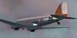
This folder contains a repaint for P3Dv4.5 PBR version of the Douglas C-47 by Manfred Jahn and colleagues in the colors of C-47 #36 of the French Navy (Aeronavale). Originally c/n9798 42-23936 it flew with the USAAF in North Africa and later in the ETO. It took part in D-Day, Market Garden and Operation Varsity, dropping parachutists. After WW2 it went to Ceskoslovenske Aeroline as OK-WDU and between 1958 and 1983 with the French navy as #36. It later went to Stellair and Transvalair in France as F-GEOM, before going to the UK as G-OFON with Classic Airways and later Air Atlantique. After a stint with South Coast Airways, it went to the Aviodrome in the Netherlands in 2006, where unfortunately it was left outside without protection. When the Aviodrome went bankrupt it went to Classic Wings, who are currently restoring it for static display in the Museum in Overloon. Repaint by Jan Kees Blom for Manfred Jahn's C-47 for P3Dv4.5, with PBR, Rivet and bump detail by Ted (Tufun) Wolfgang."
| Filename: | Douglas_C47_French_Navy_36.zip |
| License: | Freeware |
| Added: | 29th January 2020, 01:04:47 |
| Downloads: | 323 |
| Author: | Jan Kees Blom |
| Size: | 42.29 MB |
| Category: Flight Simulator 2002 - Scenery | |
| Grafton District Airport - NSW Australia |
|
File Description:
Grafton District Airport (YGFN) - (For 2002 only)
*******************************
A delighful small airport approximately 80 nautical miles from Coffs Harbour and a slightly shorter distance to Ballina and Lismore. This makes a good stopover for hopping down the east coast of Australia.
Originally released for FS2004 (and is better in 2004) but adds realism to FS2002 default airport.
The size of the airport has allowed me to put in that extra detail which makes to terminal and surrounds very much "as in real life". Photographic textures are used throughout for the buildings and even the trees are hand made macros from photographs at the airport.
AFCAD file is included to add AI traffic. For that reason and because of limited apron space no static planes have been used. You should obtain Traffic Tools to add more AI traffic to give the airport a little more life.
The scenery concentrates on adding a realistic terminal to the airport whilst leaving much of the default runway detail unchanged.
| Filename: | Grafton_District_Airport__NSW_Australia.zip |
| License: | Freeware, limited distribution |
| Added: | 7th December 2003, 03:15:56 |
| Downloads: | 480 |
| Author: | John Ross |
| Size: | 2.02 MB |
| Category: Flight Simulator X - Scenery | |
| NZOP- Opotiki Aerodrome (VectorLandClass, New Zealand) |
|
Images related to this file:
File Description:
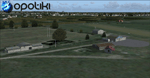
Opotiki aerodrome (ICAO: NZOP) is a small airstrip outside the township of of Opotiki, the gateway to the beautiful East coast of the North Island of New Zealand. Opotiki itself sits at the confluence of the Waioeka and Otara rivers and is surrounded by dairy farmland and Kiwifruit orchards with large areas of native bush to the south and east.
This scenery accompanies Tim Barnes'�� series of other small Bay of Plenty aerodromes (Whakatane,
Galatea, Waihi Beach) for use with VectorLandClass- It features custom modelled and textured buildings, large coverage of beautiful 0.5m aerial photography (fully auto-genned and including seasonal and night variations) and extensive use of high quality objects from the free VLC library. Installation of the library V1.1+ is required for this scenery to work properly and can be downloaded from the VectorLandClass website (www.vectorlandclass.co.nz)
This release, although not requiring it, works best with VectorLandClass topographic mesh and landclass addon covering all 268676 square kilometers of New Zealand. If you'��re not a VLC customer, you'��ll notice when the photoreal coverage runs out!
| Filename: | NZOP_Opotiki_Aerodrome_VectorLandClass_New_Zealand.zip |
| License: | Freeware, limited distribution |
| Added: | 21st February 2013, 13:52:47 |
| Downloads: | 969 |
| Author: | Tim Barnes |
| Size: | 146.68 MB |
| Category: Flight Simulator 2004 - Scenery | |
| Ocean Stations for Multiplayer Use |
|
File Description:
I've produced this scenery to provide all of the Ocean Stations I know about in the 1950's and 1960's. There is a Coast Guard ship on station (painted in the colors of the USA), an NDB to give you a bearing to the ship, a way to contact the ship using voice (you can get your position relative to the ship this way), and a DME for distances further than the limited 30 NM FS ATC gives you (normal communications would reach about 100 NM). You can also get a weather report, and if you are a seaplane you can be cleared to land. If you are a landplane, I guess this would constitute permission to ditch...
I want to give a big thank you to Mitsuya Hamaguchi (hama) for graciously supplying the ship used in this scenery.
This version uses scenery ships, which will not disappear in multiplayer. There is only a US ship, however. For the AI ship version (with ships of several countries) download OceanStations.zip instead.
| Filename: | Ocean_Stations_for_Multiplayer_Use.zip |
| License: | Freeware, limited distribution |
| Added: | 6th May 2008, 03:51:56 |
| Downloads: | 543 |
| Author: | Tom Gibson |
| Size: | 405.16 KB |
| Category: Flight Simulator 2004 - Scenery | |
| KNUQ - Moffett Federal Airfield - Mountain View - California (USA) |
|
Images related to this file:
File Description:
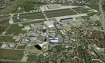
Known originally as Naval Air Station Sunnyvale after its christening in 1933, Moffett Field was renamed in 1942 in honor of Rear Admiral W.A. Moffett a founder of the Navy's Lighter than air program. By this time the LTA program had been reduced to the use of smaller dirigibles for scouting and anti-submarine work but the airfield remained immensely important as a fixed-wing facility due to it's strategic location between Seattle and San Diego. The Ames Research Center established before the war also blossomed into a major post-war aeronautical research and development center due in part to its highly advanced wind tunnel facilities. After the Second World War, Moffett Field developed into a West Coast hub for Patrol and ASW operations against encroaching Soviet missile boats. The NASA presence at Moffett began as early as 1939 with the establishment of the Aames Research Facility and evolving into the sophisticated R&D complex it is today. This particular scenery package attempts to represent the base more or less as it is today.
| Filename: | KNUQ__Moffett_Federal_Airfield__Mountain_View__Cal.zip |
| License: | Freeware |
| Added: | 21st August 2014, 10:41:53 |
| Downloads: | 1,349 |
| Author: | John Stinstrom |
| Size: | 12.36 MB |
| Category: Flight Simulator 2004 - Scenery | |
| Alaska North Slope 4: Lonely Air Force Station (AK71) |
|
Images related to this file:
File Description:
The town of Barrow is in the far north of Alaska, and these are coastal villages or radar installations to the west, south, and now east of Barrow. There will be further additions. Lonely Air Force Station AK71 is 80 miles east of Barrow and on the coast. It was, and at first sight appears still to be, a DEW station until you are close enough to see that the gravel apron is deteriorating. There is a gravel runway around 5,000 feet long, a large hangar, the DEW buildings, radar under the domes, the remains of huge line-of-sight communications reflectors, and oil tanks. Some DEW sites are not worth a visit; others are surprisingly intact and this is one of those. The AI takes place three days a week and is a C130, in which case the DEW site is still functioning or under mothball maintenance, a chartered Reeve Aleutian in which case the site is closed and they are documenting wildlife, and a Cessna with a group of the curious.
| Filename: | Alaska_North_Slope_4_Lonely_Air_Force_Station_AK71.zip |
| License: | Freeware, limited distribution |
| Added: | 20th June 2016, 08:02:18 |
| Downloads: | 306 |
| Author: | Roger Wensley |
| Size: | 2.32 MB |
| Category: Flight Simulator 2004 - Scenery | |
| Saglek CYSV in northern Labrador, Newfoundland Canada |
|
Images related to this file:
File Description:
Kangiqsualujjuaq is in northern Quebec on the east side of Ungava Bay, and the rocky coastline stretches north from there for 130 miles before turning sharply to head south as the Atlantic shore of Labrador. On this shore and 120 miles almost due east of Kangiqsualujjuaq is Saglek, once a US radar base as part of the DEW line, and then a Canadian base with a Long Range Radar sited 1,200 feet above the airstrip on the top of the vertical cliff. The airstrip is still in use today as an access to the Torngat Mountains Canadian National Park area further north, with organised summer camps and walks etc and helicopter relays from airstrip to campsites. Saglek closes the gap between my post of Kangiqsualujjuaq and the string of airfields further south on the Labrador coast, such as Nain, Davis Inlet, Hopedale, Makkovik, and Postville etc. These have all been made by Flight Ontario and posted along with the Goose Bay Air Base, which also functions as a civil airport.
| Filename: | Saglek_CYSV_in_northern_Labrador_Newfoundland_Cana.zip |
| License: | Freeware, limited distribution |
| Added: | 17th August 2017, 17:11:29 |
| Downloads: | 162 |
| Author: | Roger Wensley |
| Size: | 3.86 MB |
| Category: Flight Simulator 2004 - Scenery | |
| Terrace CYXT in BC Canada Updated |
|
Images related to this file:
File Description:
This version of Terrace has night textures that work, good news for the 319 downloaders who did not tell the author that the ones already posted did not work. Why? Terrace is fifteen miles east and inland from Prince Rupert, which is 500 miles north of Vancouver up the BC coast. It is at the point in the mountains where two fjords meet, one coming from Prince Rupert and the other from Kitimat. There are two runways, the main one is a recently-extended 7,500 feet long and lighted 33/15 and the second is 5,373 feet of unlit 03/21. The apron has been enlarged to be able to accomodate a Boeing 737; though I don't think there is an airline using a 737 for flights to Terrace I have parked an Air Canada jet and the pics show the planes that do fly to Terrace, Air Canada and Hawk Air Dash 8-300's. The aircraft and the textures are down-loadable and and can be used for AI.
| Filename: | Terrace_CYXT_in_BC_Canada_Updated.zip |
| License: | Freeware, limited distribution |
| Added: | 3rd July 2010, 03:28:31 |
| Downloads: | 1,064 |
| Author: | Roger Wensley |
| Size: | 3.72 MB |
| Category: Flight Simulator 2004 - Scenery | |
| CYYH - Taloyoak - Nunavut, Canada |
|
Images related to this file:
File Description:
Taloyoak is on the coast of northern mainland Canada, on the west of the Boothia Peninsula, where it is at it's narrowest. Gjoa Haven is 80 miles southwest, and Hall Beach is 300 miles to the east. Taloyoak was established around a Hudson Bay trading post that was relocated from Fort Ross in 1948 because of poor ice conditions. There is now a clinic, school, church, recreation centre, two markets, two small hotels, and housing for the population of around 900. The airfield is to the west of the village on higher ground at 92 feet asl, and the 4,020 feet of 100 feet wide gravel runway is aligned 151T/331T where T stands for "true" as opposed to magnetic in the Northern Domestic Airspace. Only JETA-1 is available, unless there is some 100LL in drums. There are flights by First Air and Canadian North and the AI includes a daily flight of each, plus an afternoon cargo visit by a Buffalo C46; the closest large city is Yellowknife, 750 miles southwest.
| Filename: | CYYH__Taloyoak__Nunavut_Canada.zip |
| License: | Freeware, limited distribution |
| Added: | 18th November 2012, 09:23:20 |
| Downloads: | 374 |
| Author: | Roger Wensley |
| Size: | 3 MB |
© 2001-2026 AVSIM Online
All Rights Reserved
Privacy Policy |