
Where Flight Simulation Enthusiasts Gather from Around the World!
AVSIM Library - Search Results

| Category: Flight Simulator X - Original Aircraft | |
| Bristol F2B Mk.1 (Part 4) |

|
File Description:
Flight Simulator X version of the Bristol Fighter Mk.1 or 'Biff' as it was called by it's crews in WW1. This file is part 4 of a 4 part download and contains visual models and textures depicting 4-blade propeller versions, D8084 of No 139 Sqdn RAF and B1112 of No.22 Sqdn RFC/RAF. This file requires the prior successful installation of part 1 (F2BX1Pt1.zip), which contains common textures. Parts 2 & 3 are optional. This aircraft was modeled using 3DS Max 8.0 and compiled using FSX SDK tools and will only work in FSX or higher. It is NOT compatible with FS2004. The aircraft makes full use of FSX materials and also features skinned animated crew members in the external model. It also features a detailed virtual cockpit. All instruments, levers and selectors are modeled in the 3D model. It does not use the FSX gauge system and there is NO 2D cockpit.
| Filename: | Bristol_F2B_Mk1_Part_4.zip |
| License: | Freeware, limited distribution |
| Added: | 2nd February 2007, 03:23:26 |
| Downloads: | 5,525 |
| Author: | Robert Bruce |
| Size: | 17.22 MB |
| Category: Flight Simulator X - Flight Plans | |
| Rocky Mountain Airport Tour |
|
File Description:
Rocky Mountain Airport Tour:
A very hard flight plan in common GA Aircraft. I flew this with a Carenado B58. VFR Flight with wild swings in Altitudes. Maintain 16000 (One Six Thousand) feet for most of the flight to and from the airports. You will have to fly around mountains on approaches with steep short field finals. GPS flight plan is just a guide. You will have to follow the mountain passes from some airports in order to attain sufficient altitude (in some cases). Don't wimp out! Max load your plane.
Country: USA
State: Cololorado
Start: KDRO (Make sure you start from a parking spot)
End: KHDN
Most difficult: Taking off at Buckhorn Ranch (8000+ feet ALT, 4000 FT Runway)
Toughest area between airports:
KASE to KEGE
Time to compleat: about 3 hours
Good Luck.
Questions Contact me at AVSIM
Avsim ID: hawkDsl
To Install: Copy "Rocky Mountain Airport Tour.pln" and paste it into you FSX flight plan file
Win7 : userfiles/my document/Flight Simulator X Files
| Filename: | Rocky_Mountain_Airport_Tour.zip |
| License: | Freeware |
| Added: | 21st July 2012, 13:26:52 |
| Downloads: | 473 |
| Author: | Henry Oeser |
| Size: | 1.94 KB |
| Category: Flight Simulator X - Original Aircraft | |
| BrightStar Swift |
|
File Description:
BrightStar Swift for FSX and FS2004...The SWIFT, for Swept Wing with Inboard Flap for Trim, was designed by a team at Stanford University led by Dr. Ilan Kroo, and developed through a collaborative effort with BrightStar Gliders as a high performance foot-launched sailplane, Although it is a fully-cantilevered rigid wing with aerodynamic controls and flaps, it weighs only about 100 lbs and is easily transported on the top of a car.
Almost doubling the performance of conventional hang gliders at the time it was introduced,it dominated several competitions and was subsequently allowed to compete only in a separate class. Many pilots have flown the SWIFT for 100-200 miles.
BrightStar originally manufactured SWIFTs in the U.S. but subsequently sold the licence to the Belgian company Aeriane
This model made with g-Max features full aircraft animations and a running pilot during landing and take-off,detailed VC cockpit and custom built gauges.
: September 2008
| Filename: | BrightStar_Swift.zip |
| License: | Freeware, limited distribution |
| Added: | 22nd September 2008, 13:12:24 |
| Downloads: | 4,976 |
| Author: | David Rowberry |
| Size: | 6.78 MB |
| Category: Flight Simulator 2004 - Scenery | |
| Anticosti Island in Quebec Canada |
|
Images related to this file:
File Description:
Anticosti Island is in the Gulf of St Lawrence, around 25 miles off the Quebec mainland coast. It is some 40 miles wide and 130 miles long on an east west axis. There are few urban areas and only one that can be described as a small town, namely Port Menier at the western end of the southern coast, with a population of under 1,000. There is a ferry service to the harbour. The airport, Port Menier CYPN, is around 3 miles northeast of the town, with an asphalt runway aligned 11-28, 4,875 feet long and 150 feet wide with PAPI at each end. In 2010 (the approximate date of this scenery) a gravel runway was still visible at the eastern end of the field. This was no longer in use by 2010, except perhaps by small planes on skis in the winter. The island, with its small population, small urban area, and no industry other than logging, has as a result a mainly undisturbed wildlife population. This has made deer hunting and fishing the main tourist activities, with one company (called Safari) having an exclusive licence to exploit large areas of mountains and rivers. Planeloads of hunters and fishermen are flown in on chartered Nolinor Aviation planes from the south. There are a further two airfields in the eastern end of the island, and in 2010 Rivere-Aux-Saumons CTH7 had a 5,500 feet gravel runway, linked by road to a lodge area at the mouth of the river. This is the only lodge area that I have been able to locate, but there are others. To the south Riviere Bell CRB5 had at that time a gravel runway that was 3,000 feet long. This has been lengthened since then and both runways were recently (2021) asphalted. If you find an error email me please, and note that my email address has been changed to rogwens at Gmail dot com.
| Filename: | Anticosti_Island_in_Quebec_Canada.zip |
| License: | Freeware, limited distribution |
| Added: | 31st July 2021, 18:23:40 |
| Downloads: | 80 |
| Author: | Roger Wensley |
| Size: | 11.78 MB |
| Category: Flight Simulator 2004 - Scenery | |
| CYDA - Dawson City - Yukon Territory, Canada |
|
Images related to this file:
File Description:
Dawson City is in the Yukon Territory, Canada, 140 miles south of Old Crow and about the same north of Whitehorse. The town has a population of just over 1,300 and is on the bank of the Yukon River; it is busy with nearby gold mining and tourism. There are regular flights by Air North, the Yukon airline, and I have included them in the AI along with ConAir and GA. Thanks go to Hernan for his Air North textures. The airport is beside the Klondike Highway that links Dawson City to Whitehorse, a few miles southwest of the town and the river. The runway approaches are steeper than most because of the surrounding hills and the Canada Flight Supplement notes that use is restricted to daylight hours, with some exceptions including emergencies. Runway 20 has right hand circuits. The runway is gravel and just over 5,000 feet long, aligned 02-20. There is a second apron for the activities of ConAir etc in the summer fire-fighting months. The "masts" are actually for fire hose drying; the ends of several 50 feet lengths are attached to a circular holder that is then pulled up to the top of the central pole.
| Filename: | CYDA__Dawson_City__Yukon_Territory_Canada.zip |
| License: | Freeware, limited distribution |
| Added: | 27th December 2014, 20:31:31 |
| Downloads: | 377 |
| Author: | Roger Wensley |
| Size: | 3.96 MB |
| Category: Flight Simulator 2004 - Scenery | |
| Mahlon Sweet Field - Eugene, Oregon (KEUG) |
|
File Description:
KEUG - Mahlon Sweet Field - Eugene, Oregon. Eugene, home of University of Oregon, is located at the South end of the Willamette Valley, at the confluence of the McKenzie and Willamette rivers, about 60 miles (100 km) East of the Oregon Coast. The airport is the fifth largest airport in the Pacific Northwest, providing commercial air service to a six-county region in mid-Oregon. This package is a modest enhancement of KEUG based on the Afcad originally created by Reiley McKendrick. Included are minor corrections to his afcad, excludes which remove objects from the taxiway area leading to the NEW 34R/16L runway and numbered jetways at the main terminal. All required files and textures are included. This enhancement is designed to work with the default FS2004 scenery and is offered as a basis for further enhancement. Please unzip (using folders option) to a temporary folder and follow the simple installation instructions. Compiled for your flying enjoyment by David "Opa" Marshall.
| Filename: | Mahlon_Sweet_Field__Eugene_Oregon_KEUG.zip |
| License: | Freeware |
| Added: | 18th December 2006, 01:07:05 |
| Downloads: | 1,021 |
| Author: | David "Opa" Marshall |
| Size: | 465.02 KB |
| Category: Flight Simulator 2004 - Scenery | |
| VFR of Lario, Area C3 - Como lake, Italy |
|
Images related to this file:
File Description:
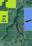
This is the twelfth scenery of the "VFR of Lario" project, made with
photorealistic terrain (multiseason & night) and with some 3D GMax realistic objects.
This scenery covers approximately an area of 7.5x6 kmt, from Limonta (NW) to the northern Grigna mountain (NE), from Onno (SW) to southern Grigna mountain (SE); some of specific buildings are included, as the small church and Museum of Cycling (Ghisallo), villa at pier (Limonta) and interruption of the freeway overpass (Mandello del Lario ... waiting for the next B3 scenery); are included five NLC piers (Limonta, Onno, Vassena, Lierna and Mandello del Lario) and two small motorboat (Ninfea and Giglio) of the NLC navigation; there are also included six sections of the freeway SS36 with its overpasses and tunnels. Some other minor boats and docks are placed alongside the lake coast.
Check video available here: http://youtu.be/q9I5B6oF4ZY
| Filename: | VFR_of_Lario_Area_C3__Como_lake_Italy.zip |
| License: | Freeware |
| Added: | 30th April 2013, 23:20:59 |
| Downloads: | 827 |
| Author: | Aldo Della Vedova, Daniele Lanfranchi, Gian Mario Verga |
| Size: | 22.95 MB |
| Category: Flight Simulator 2004 - Scenery | |
| North and Middle Farallon Islands Version 3 Update |
|
File Description:
Beta version 3 update: Adds the North and Middle Farallon Islands to the chain. To be used in conjunction with the Southeast Farallon Island Version 3 download available separately. These islands were mysteriously absent from the FS2004 default scenery, probably owing to their small size. When I went to look for them I found a small mountain of water instead of the islands. Most people don't seem to be aware of the Farallon Islands. Located off the coast of California, near San Francisco, they are home to thousands of birds, seals, and some of the largest Great White sharks known to man. All of this is within a very short distance of the city. Today, it is a wildlife refuge and is off limits to visitation by the general public. Those of you interested in more info might check out "The Devil's Teeth" by Susan Casey. These islands were created as scenery objects instead of traditional terrain in order to preserve detail.
| Filename: | North_and_Middle_Farallon_Islands_Version_3_Update.zip |
| License: | Freeware, limited distribution |
| Added: | 24th November 2005, 14:48:25 |
| Downloads: | 851 |
| Author: | Glen Gordon (Prof K.) |
| Size: | 319.86 KB |
| Category: Flight Simulator X - Aircraft Repaints, Textures and Modifications | |
| "The Shark" P-51D Mustang (G-SHWN) |
|
Images related to this file:
File Description:
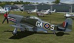
This is a repaint for the payware Warbirdsim P-51D "Mustang Tales" product. This repaint depicts the restored P-51D 44-73877, registered in the UK as G-SHWN, owned by Shaun Patrick and which is flown under loan to the Boultbee Flight Academy and Norwegian Spitfire Foundation. Based at Chichester/Goodwood Airport, the aircraft is painted in the authentic markings of an RAF 112 Squadron Mustang Mk.IVa (P-51K), KH774, which in 1945 was based at Cervia, Italy. The original aircraft was piloted by a Lt. Blanchford, flying ground-attack missions over the Balkans and along the Adriatic coast. This aircraft has previously been owned/operated for many years by the Scandinavian Historic Flight (prior paint schemes included "Detroit Miss" and "Old Crow", among others). This aircraft can be seen in the 1990 movie "Memphis Belle", painted as "Cisco", and the 2012 movie "Red Tails". New bump maps and modified cockpit textures included.
| Filename: | The_Shark_P51D_Mustang_GSHWN.zip |
| License: | Freeware |
| Added: | 7th July 2017, 17:11:25 |
| Downloads: | 188 |
| Author: | John Terrell |
| Size: | 30.55 MB |
| Category: Flight Simulator 2004 - Scenery | |
| Southeast Farallon Islands Version 2 |
|
File Description:
SIGNIFICANTLY ENHANCED UPGRADE OF PRIOR VERSION. These islands were mysteriously absent from the FS2004 default scenery, probably owing to their small size. When I went to look for them I found a small mountain of water instead of the islands. Most people don't seem to be aware of the Farallon Islands. Located off the coast of California, near San Francisco, they are home to thousands of birds, seals, and some of the largest Great White sharks known to man. All of this is within a very short distance of the city. Today, it is a wildlife refuge and is off limits to visitation by the general public. Those of you interested in more info might check out "The Devil's Teeth" by Susan Casey. This island is actually a scenery object. As such it doesn't have a landable surface. Future versions will have a helicopter pad, a lighthouse, and the 100 year old houses used by researchers.
| Filename: | Southeast_Farallon_Islands_Version_2.zip |
| License: | Freeware, limited distribution |
| Added: | 19th November 2005, 23:35:28 |
| Downloads: | 793 |
| Author: | Glen Gordon (Prof K.) |
| Size: | 1.62 MB |
© 2001-2026 AVSIM Online
All Rights Reserved
Privacy Policy |