
Where Flight Simulation Enthusiasts Gather from Around the World!
AVSIM Library - Search Results

| Category: Flight Simulator 2004 - Scenery | |
| Anaktuvuk Pass PAKP in Alaska |

|
Images related to this file:
File Description:
Anaktuvuk Pass is a village located 85 miles north of Bettles and just north of the Brooks Range, in a valley that is a route between north and south. The inhabitants are mainly Numamiut, a section of the Inupiat that existed in history (and until today) away from the coastal food supply of fish etc. The current population is around 350. The airport has one gravel runway, aligned 1-19 with PAPI at both ends, and 5,500 feet long as there is no connection to the outside world other than the runway for all necessities that are not available on the tundra. There are two aprons, with light planes and passengers at the northern end of the runway and the Everts cargo flights unloading at the mid runway apron. A note here about my scenery making. There will not be many more to follow this as I am almost at the end of the photos I either took or found for scenery purposes, plus I expect to move on from FS9 at some point during next year.
| Filename: | Anaktuvuk_Pass_PAKP_in_Alaska.zip |
| License: | Freeware, limited distribution |
| Added: | 25th November 2019, 17:51:38 |
| Downloads: | 244 |
| Author: | Roger Wensley |
| Size: | 8.59 MB |
| Category: Flight Simulator 2004 - Original Aircraft | |
| Lockheed L-1049 Super G Constellation |
|
Images related to this file:
File Description:
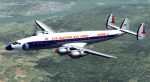
Lockheed L-1049G Super Constellation V2 - This re-uploaded version integrates the changes of the 20 May 2009 Update pack released elsewhere.
First flown in December 1954, the "Super G" was the most successful and
prestigious civil variant of Lockheed's Super Constellation series. It could
carry up to 99 passengers, and optional wing-tip tanks holding 600 gallons
each enabled it to comfortably fly the popular long-distance routes.
Included in the package are four models representing aircraft with and
without radar noses and tip tanks.
Natural metal TWA and Eastern textures by
Eric Joiner, KLM texture by Marcel Ritzema, panel textures and additional
gauges by Diego S. Barreto. Model, VC, and texture basics by Manfred Jahn,
panels, gauges, and animations by Hansjoerg Naegele, flight dynamics by Luis
Pallas, wingview angles by Bill Tyne and Andreas Trapp, lights and exhaust
effects by Roland Berger, checklist and documentation by Volker Boehme,
flight test and handling research by Stefan Werner. The 1049 project is
hosted by Tom Gibson's Calclassic forum at
http://calclassic.proboards55.com.
| Filename: | Lockheed_L1049_Super_G_Constellation.zip |
| License: | Freeware |
| Added: | 11th December 2009, 00:50:19 |
| Downloads: | 7,766 |
| Author: | Manfred Jahn and Team 1049 |
| Size: | 31.33 MB |
| Category: Flight Simulator 2004 - AI Aircraft | |
| North American F-100 Super Sabre (Part 2) |
|
Images related to this file:
File Description:

North American F-100 Super Sabre (Part 2). This aircraft, also known as the Hun, was the first of a long success of Century Series fighter aircraft during the 1950s and 1960s. I present a comprehensive 8-LOD AI traffic model for this cold warrior of military jet history, utilizing original source material from Jake Burrus. Going into production in 1953, 2,294 aircraft served thirty-five years in the USAF and the air forces of France, Turkey, Denmark, and Taiwan. The F-100 was originally designed as a daytime air superiority fighter (with all-cannon armament); but evolved into a capable light attack aircraft which served extensively in Vietnam. An original 8-LOD model brings this historic aircraft to the flightsim world. This Part 2 package represents the F-100D in the pre-Vietnam service of the USAF,with a total of 6 models and 112 repaints. Original aircraft model by Jake Burrus and Michael Pearson, textures by Michael Pearson, flight dynamics by Michael MacIntyre. Please read included documentation.
| Filename: | North_American_F100_Super_Sabre_Part_2.zip |
| License: | Freeware |
| Added: | 18th February 2014, 00:18:08 |
| Downloads: | 781 |
| Author: | Michael Pearson |
| Size: | 28.26 MB |
| Category: Flight Simulator X - Aircraft Repaints, Textures and Modifications | |
| P-51D Swedish Air Force 26152 |
|
File Description:
This folder contains a repaint for the Shockwave World War II Fighters P-51D Mustang. Repaint by Jan Kees Blom, based on the repaint kit by John Terrell. It is for FSX only, as it contains 2048 x 2048 textures. For FS9, look for my earlier "Sierra Sue II" repaint, which contains a low res version of this repaint.
This aircract represents a J-26 of the Royal Swedish Air Force. A/C 26152 was previously 44-63675 E6-D "Sierra Sue II" of the 402nd FS, USAAF, flown by Lt. Bob Bohna. She was sold to Sweden after the war and flew with with 3rd squadron of the F4 wing, based on the island of Froson, with Cpl Sten Soderquist as her regular pilot. In 1954, she was sold to Nicaragua were she flew with registration GN91. She came to the US in 1970 and is currently owned by Roger Christgau, who flies her as "Sierra Sue II / Gul Kalle". Repaint by Jan Kees Blom, based on the repaint kit by John Terrell.
| Filename: | P51D_Swedish_Air_Force_26152.zip |
| License: | Freeware |
| Added: | 25th December 2008, 20:11:58 |
| Downloads: | 200 |
| Author: | Jan Kees Blom |
| Size: | 24.3 MB |
| Category: Flight Simulator 2004 - Scenery | |
| Sanikiluaq CYSK in Hudson Bay, Nunavut, Canada |
|
Images related to this file:
File Description:
Sanikiluaq is a village 740 or so inhabitants at N56 30, W79, which means in the southern part of Hudson Bay, close to James Bay. The village is at the north end of Flaherty Island, which is the largest of the Belcher Islands. You might fly there from La Grande Riviere in Quebec (200 miles SSE) or maybe from Moosonee in Ontario at the bottom of James Bay (350 miles SSW). Sanikiluaq village does not feature in FS9, so the first thing to do was to add it; it is the right shape and with around the right number of houses on the right streets but as I wasn't going to model 100+ individual houses just think of it as a hand-made auto-generated village. I also had to move the airfield over beside the river, so there is a DELETE file and a GRASS file and a ROADS file, as well as an AFCAD for AI and a scenery file. And AI for a visiting Air Inuit plane.
| Filename: | Sanikiluaq_CYSK_in_Hudson_Bay_Nunavut_Canada.zip |
| License: | Freeware, limited distribution |
| Added: | 11th October 2010, 23:15:41 |
| Downloads: | 516 |
| Author: | Roger Wensley |
| Size: | 2.21 MB |
| Category: Flight Simulator X - Scenery | |
| Scappoose Industrial Airpark |
|
Images related to this file:
File Description:
Presenting KSPB Scappoose, Oregon Industrial Airpark, for FSX only. This is a nice area on the way from Portland, OR to St. Helens,OR around the Sauvie Island area.
ICAO is KSPB as mentioned above. VOWDME is 114.00 60nm range, ILS is 111.10 at 27 nm range.
This includes photo real file at high res for clarity. I made the red barn from pictures I found. One picture is included for comparison. This includes the mailbox and flower arrangement adjacent to it just for fun. Included are a few houses in the barn area and fencing which I did the best I could with what I have at the time.
Default vehicles and planes are added, but not too many so as not to cause frame rates issues. Included are a 55 Ford truck I made and one called fordtruck2 which is not as good as the '55 ford is, but I got in a rush...but it worked well. Enjoy. contact info is in the readme file. Bob
| Filename: | Scappoose_Industrial_Airpark.zip |
| License: | Freeware |
| Added: | 1st August 2012, 13:12:51 |
| Downloads: | 517 |
| Author: | Robert Lacy |
| Size: | 60.24 MB |
| Category: Flight Simulator 2004 - Scenery | |
| Tofino CYAZ 2012 |
|
Images related to this file:
File Description:
I've always had a particular fondness for Tofino CYAZ, located on the west coast of Vancouver Island. I made my first Tofino scenery in 2005 using Lago's FSE, and an updated version in 2006 using EZ-Scenery. Neither of those included custom models. This final version is a complete, from-the-ground-up rebuild. Every building and many of the other scenery objects are custom made based on photos and using photo textures. (The images in the "Tour" folder will take you on a tour of the real and virtual airport.) In the time since the first two virtual versions were made, a new terminal building has been added to the east ramp at the real Tofino, along with some new hangers, and the scenery includes these changes. Tofino has an NDB instrument approach (CYAZ NDB A.pdf), but night operations are not allowed. For this reason the new terminal building has no night lighting. The golf clubhouse restaurant and pro shop are open after dark for your shopping and dining pleasure. This scenery represents many hours of work...I hope you enjoy it.
| Filename: | Tofino_CYAZ_2012.zip |
| License: | Freeware |
| Added: | 19th August 2012, 14:33:09 |
| Downloads: | 650 |
| Author: | Sidney Schwartz |
| Size: | 10.14 MB |
| Category: Flight Simulator X - Scenery | |
| NZOP- Opotiki Aerodrome (VectorLandClass, New Zealand) |
|
Images related to this file:
File Description:
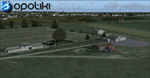
Opotiki aerodrome (ICAO: NZOP) is a small airstrip outside the township of of Opotiki, the gateway to the beautiful East coast of the North Island of New Zealand. Opotiki itself sits at the confluence of the Waioeka and Otara rivers and is surrounded by dairy farmland and Kiwifruit orchards with large areas of native bush to the south and east.
This scenery accompanies Tim Barnes'�� series of other small Bay of Plenty aerodromes (Whakatane,
Galatea, Waihi Beach) for use with VectorLandClass- It features custom modelled and textured buildings, large coverage of beautiful 0.5m aerial photography (fully auto-genned and including seasonal and night variations) and extensive use of high quality objects from the free VLC library. Installation of the library V1.1+ is required for this scenery to work properly and can be downloaded from the VectorLandClass website (www.vectorlandclass.co.nz)
This release, although not requiring it, works best with VectorLandClass topographic mesh and landclass addon covering all 268676 square kilometers of New Zealand. If you'��re not a VLC customer, you'��ll notice when the photoreal coverage runs out!
| Filename: | NZOP_Opotiki_Aerodrome_VectorLandClass_New_Zealand.zip |
| License: | Freeware, limited distribution |
| Added: | 21st February 2013, 13:52:47 |
| Downloads: | 969 |
| Author: | Tim Barnes |
| Size: | 146.68 MB |
| Category: Flight Simulator 2004 - Scenery | |
| Little Port Walter for Holger Sandmann's Tongass Fjords scenery |
|
Images related to this file:
File Description:
This is a second fish farm at the southern end of Baranof Island and Chatham Strait in southern Alaska. Big Port Walter is named on the chart of the area, and there is a section of the chart included here. Little Port Walter is a much smaller offshoot bay, sheltered from the weather and ideal for a fish farm. This scenery is designed specifically for use in the Tongass Fjord scenery. I may have incorrectly identified Tongass Fjords as being required for Hawk Logging when Glacier Bay is needed. Ah well, it is one or the other of them. The fish farm (or hatchery, the description varies) has an identifying code so it will show up on a gps as PWL. There is no interaction with atc as there are no designated water runways, so PWL on the gps just acts as a waypoint. There will be further posts for use with Tongass Fjords, Misty Fjords, and Glacier Bay, and I still find these scenery areas by Holger and his crew the most satisfying in FS9.
| Filename: | Little_Port_Walter_for_Holger_Sandmanns_Tongass_Fj.zip |
| License: | Freeware, limited distribution |
| Added: | 23rd November 2014, 01:33:12 |
| Downloads: | 235 |
| Author: | Roger Wensley |
| Size: | 3.38 MB |
| Category: Flight Simulator 2004 - Scenery | |
| PASY - Shemya (Eareckson Air Station) - Alaska, USA |
|
Images related to this file:
File Description:
Shemya is pretty well AT the western end of the Aleutian chain of islands in Alaska, around 240 miles west of Amchitka. There is no town on Shemya and the whole island is occupied (and owned) by the Air Force. There are three runways, two of which are from the 1940's and are now unused; in fact one of them has been partly ploughed up and also used for outdoor storage. The single in-use runway is aligned 10-28 and is 10,000 feet of 150 feet wide asphalt with an ils on 28, the runway that is used 99% of the time. The base is now not active but is maintained as a refuelling facility, so for landing and takeoff purposes it is open. The older and now unused areas are those where the hangers are slowly rusting away and the asphalt is turning green with encroaching and well-watered wildlife plants. The tower is now closed, so there is no atc and you just announce your intentions. Read the history of Shemya, a lot happened there.
| Filename: | PASY__Shemya_Eareckson_Air_Station__Alaska_USA.zip |
| License: | Freeware, limited distribution |
| Added: | 18th February 2015, 19:52:36 |
| Downloads: | 453 |
| Author: | Roger Wensley |
| Size: | 8.81 MB |


© 2001-2026 AVSIM Online
All Rights Reserved
Privacy Policy |