
Where Flight Simulation Enthusiasts Gather from Around the World!
AVSIM Library - Search Results

| Category: Prepar3D V1-4 - Aircraft Repaints, Textures and Modifications | |
| VASP 1998 AI Package |

|
File Description:
VASP was the 2nd largest airline in Brazil, but was scaling down by 1998. VASP still had a great international network stretching to ATH/KIX/ICN/LAX/YYZ/JFK/BCN/ZRH ect. A fleet of 10 MD-11s did all the long haul flying, as well as plenty of domestic flights. 3 A300s and a large 737-200/300 fleet served the domestic routes. While VARIG was based in GIG, VASP was based in GRU and the planes tend to hang out there. There was only 1 special livery, which was a named MD-11, so not much variation unlike VARIG. VASP did serve SDU and CGH with mainline equipment, however, so these plans will help populate those airports. Included are repaints by Raphael Rodrigues for the FAIB 737-200, 737-300, FSPX MD-11, and TFS A300B4. Flightplans by Chasen Richardson. Part of the 1998 Flight Simulator Project. Follow us on Facebook at facebook.com/flightsim98 and on instagram as @bayviationsim. For more Retro AI, check out the forums at: http://retroai.proboards.com/
| Filename: | VASP_1998_AI_Package.zip |
| License: | Freeware, limited distribution |
| Added: | 29th October 2019, 07:18:35 |
| Downloads: | 303 |
| Author: | Raphael Rodrigues, Chasen Richardson/Bayviation |
| Size: | 4.51 MB |
| Category: Flight Simulator 2004 - Scenery | |
| Howick Airfield (FAHC), South Africa |
|
Images related to this file:
File Description:
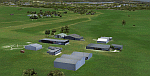
This package will add a custom (Gmax) made Howick Airfield (FAHC), KwaZulu Natal, South Africa with photoreal textures and seasonal ground textures.
Howick is a small town in the KwaZulu Natal Midlands just off the N3 freeway which connects Johannesburg and Durban and home to the famous Howick waterfall. The Umgeni river falls 95m (311 ft) over the cliffs on the way to the Indian Ocean. The town is also home to the Midmar dam. This dam is very well known as being the location of the annual Midmar Mile swimming event which, in 2009, was recognized by the Guinness Book of World Records as the world's largest open water swimming event with 13 755 competitors taking part.
The sloped grass runway is aligned 16/34 and 825m long and sits at an elevation of 3 615ft. Both runways have obstacles on the approach, with powerlines 730m from the threshold of runway 16, while runway 34's approach have hills around 900m before the threshold. The sloped runway has been created in FS2004 within the limits of the simulator itself.
| Filename: | Howick_Airfield_FAHC_South_Africa.zip |
| License: | Freeware, limited distribution |
| Added: | 15th January 2021, 20:25:51 |
| Downloads: | 201 |
| Author: | Kobus van Wyk |
| Size: | 7.67 MB |
| Category: Flight Simulator 2004 - Scenery | |
| McKenzie Airfield, Richmond, South Africa |
|
Images related to this file:
File Description:
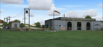
Have you ever visited the "Hangar Cafe"? Great place to have a meal and get lost in conversation with fellow aviators and aviation lovers.
McKenzie Airfield does not appear in the default FS2004, neither is the town of Richmond included. This package will add a custom (Gmax) made McKenzie Airfield (AWK5), Richmond, KwaZulu-Natal, South Africa with photoreal textures and ground textures. The included Landclass file will also add the town.
The small airfield as well as the adjacent McKenzie Plant-hire yard, has been recreated with custom true to life models and photoreal textures. McKenzie airfield is also home to the "Hangar Cafe" and an ex-SAAF Bosbok. The runway is not too challenging, just keep the aircraft in the middle and away from the trees right next to the runway. All the electrical high-wires have also been included in the scenery as it plays a prominent role in the look and feel of the airfield as has the flower beds.
The grass runway is aligned 11/29 and only 800m long.
| Filename: | McKenzie_Airfield_Richmond_South_Africa.zip |
| License: | Freeware, limited distribution |
| Added: | 7th October 2021, 22:56:00 |
| Downloads: | 123 |
| Author: | Kobus van Wyk |
| Size: | 6.5 MB |
| Category: Flight Simulator X - Aircraft Repaints, Textures and Modifications | |
| Upgrade pack - Airbus A318 FD Special Version from V2 to V3 (update pack only) |
|
Images related to this file:
File Description:

This Pack is only to update my aircraft "Airbus A318 FD Special Version V2" (pa318fd_v2_299527.zip) with a new ehanced panel that I have created with the Airbus A321.
This new panel version (v3.05) provides many new features to the version V2 of the aircraft: New fuel system management gauge like the real Airbus, full manual engines startup procedure, with all new BLEED circuit (with new Bleed page on ECAM with animations), all fuel valves, pumps, crossfeed work. All bleed valves work. Engines failure procedure management, ehanded Navigation display with TCAS on ARC or NAV mode, gps Approach procedure sheme on the navigation display, corrected electrical circuit, and many other features (too long to describe here).
There is a user manual in English and in French. Very important to read it (for the manual engines startup procedure). You must have the orignal aircraft installed on your computer (Aribus A318 FD Special version V2) because this pack is only an update. Please, read the pdf installation file (English and French version) for full information on installing this update.
| Filename: | Upgrade_pack__Airbus_A318_FD_Special_Version_from_V2_to_V3_update_pack_only.zip |
| License: | Freeware, limited distribution |
| Added: | 17th June 2012, 13:21:38 |
| Downloads: | 2,928 |
| Author: | Francois Dore |
| Size: | 19.29 MB |
| Category: Flight Simulator 2004 - Scenery | |
| Terrace CYXT in British Columbia, Canada - REVISED |
|
Images related to this file:
File Description:
This version includes the correct Piper Cub texture, unreported by all but one downloader (why?).
Terrace is fifteen miles east and inland from Prince Rupert, which is 500 miles north of Vancouver up the BC coast. It is at the point in the mountains where two fjords meet, one coming from Prince Rupert and the other from Kitimat. The airport is a couple of miles south of the town and on the south side of the Skeene River. There are two runways, and the main one is a recently-extended 7,500 feet long and lighted 33/15. The second is 5,373 feet of unlit 03/21. The apron has been enlarged to be able to accommodate a Boeing 737 so I have parked an Air Canada jet there, but the pics show the planes that do fly to Terrace, and these are Air Canada and Hawk Air Dash 8-300's. The original aircraft and the textures are down-loadable and and can be used for AI.
| Filename: | Terrace_CYXT_in_British_Columbia_Canada__REVISED.zip |
| License: | Freeware, limited distribution |
| Added: | 21st February 2010, 16:25:38 |
| Downloads: | 1,110 |
| Author: | Roger Wensley |
| Size: | 3.39 MB |
| Category: Flight Simulator 2004 - Original Aircraft | |
| Lockheed L-1049 Super G Constellation |
|
Images related to this file:
File Description:
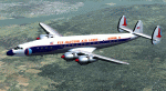
Lockheed L-1049G Super Constellation V2 - This re-uploaded version integrates the changes of the 20 May 2009 Update pack released elsewhere.
First flown in December 1954, the "Super G" was the most successful and
prestigious civil variant of Lockheed's Super Constellation series. It could
carry up to 99 passengers, and optional wing-tip tanks holding 600 gallons
each enabled it to comfortably fly the popular long-distance routes.
Included in the package are four models representing aircraft with and
without radar noses and tip tanks.
Natural metal TWA and Eastern textures by
Eric Joiner, KLM texture by Marcel Ritzema, panel textures and additional
gauges by Diego S. Barreto. Model, VC, and texture basics by Manfred Jahn,
panels, gauges, and animations by Hansjoerg Naegele, flight dynamics by Luis
Pallas, wingview angles by Bill Tyne and Andreas Trapp, lights and exhaust
effects by Roland Berger, checklist and documentation by Volker Boehme,
flight test and handling research by Stefan Werner. The 1049 project is
hosted by Tom Gibson's Calclassic forum at
http://calclassic.proboards55.com.
| Filename: | Lockheed_L1049_Super_G_Constellation.zip |
| License: | Freeware |
| Added: | 11th December 2009, 00:50:19 |
| Downloads: | 7,742 |
| Author: | Manfred Jahn and Team 1049 |
| Size: | 31.33 MB |
| Category: Flight Simulator 2004 - Scenery | |
| Gang Ranch CAY2 in British Columbia Canada |
|
Images related to this file:
File Description:
Gang Ranch is on the eastern side of the Coast Mountains of British Columbia, around 50 miles west of Green Lake and 5 miles west of the Fraser River that runs north-south at that latitude (51 degrees 30 minutes north, in round figures). The airfield is among some farm fields and difficult to spot (this will depend on your personal textures and settings) and the ranch buildings are scattered and a mile or two away, the nearest being the owner's house. The runway is gravel, only 1,800 feet long and aligned 08-26 at 2,150 feet above sea level. There is no lighting. I have posted it as Gang Ranch CAY2, but I suggest that you just add it to your previously created "BC airfields" (if you did that) and avoid the inevitable doubling up of common textures etc. Plus that way you will have just one FS9 library post to do and new airfields will not need yet another posting. Up to you. If you find a defect, email me.
| Filename: | Gang_Ranch_CAY2_in_British_Columbia_Canada.zip |
| License: | Freeware, limited distribution |
| Added: | 19th November 2020, 19:44:55 |
| Downloads: | 100 |
| Author: | Roger Wensley |
| Size: | 8.98 MB |
| Category: Flight Simulator 2004 - Scenery | |
| Little Port Walter for Holger Sandmann's Tongass Fjords scenery |
|
Images related to this file:
File Description:
This is a second fish farm at the southern end of Baranof Island and Chatham Strait in southern Alaska. Big Port Walter is named on the chart of the area, and there is a section of the chart included here. Little Port Walter is a much smaller offshoot bay, sheltered from the weather and ideal for a fish farm. This scenery is designed specifically for use in the Tongass Fjord scenery. I may have incorrectly identified Tongass Fjords as being required for Hawk Logging when Glacier Bay is needed. Ah well, it is one or the other of them. The fish farm (or hatchery, the description varies) has an identifying code so it will show up on a gps as PWL. There is no interaction with atc as there are no designated water runways, so PWL on the gps just acts as a waypoint. There will be further posts for use with Tongass Fjords, Misty Fjords, and Glacier Bay, and I still find these scenery areas by Holger and his crew the most satisfying in FS9.
| Filename: | Little_Port_Walter_for_Holger_Sandmanns_Tongass_Fj.zip |
| License: | Freeware, limited distribution |
| Added: | 23rd November 2014, 01:33:12 |
| Downloads: | 233 |
| Author: | Roger Wensley |
| Size: | 3.38 MB |
| Category: Flight Simulator 2004 - Scenery | |
| Sanikiluaq CYSK in Hudson Bay, Nunavut, Canada |
|
Images related to this file:
File Description:
Sanikiluaq is a village 740 or so inhabitants at N56 30, W79, which means in the southern part of Hudson Bay, close to James Bay. The village is at the north end of Flaherty Island, which is the largest of the Belcher Islands. You might fly there from La Grande Riviere in Quebec (200 miles SSE) or maybe from Moosonee in Ontario at the bottom of James Bay (350 miles SSW). Sanikiluaq village does not feature in FS9, so the first thing to do was to add it; it is the right shape and with around the right number of houses on the right streets but as I wasn't going to model 100+ individual houses just think of it as a hand-made auto-generated village. I also had to move the airfield over beside the river, so there is a DELETE file and a GRASS file and a ROADS file, as well as an AFCAD for AI and a scenery file. And AI for a visiting Air Inuit plane.
| Filename: | Sanikiluaq_CYSK_in_Hudson_Bay_Nunavut_Canada.zip |
| License: | Freeware, limited distribution |
| Added: | 11th October 2010, 23:15:41 |
| Downloads: | 515 |
| Author: | Roger Wensley |
| Size: | 2.21 MB |
| Category: Flight Simulator 2004 - AFCAD Files | |
| T.F. Green State Airport - Providence (PVD/KPVD) |
|
File Description:
AFCAD of the KPVD airport. Includes accuarate gate numbering and locations for all airlines serving the airport as well as assigned cargo areas and parking for general aviation aircraft. This is my continuing series of doing airports that have been neglected by both MS and the community. Hopefully this will enhance flying into this airport for those of you that frequent it. Terminal space for this airport is actually slightly better then previous airports I've done but still a bit on the small side, I've had to expand the ramp space from the default since it was shaped wrong. Every gate, however, is present and correctly numbered and airlines assigned to the right gates based on the PVD airport website. Delta, US Airways and Southwest seem to be the dominant carriers to this airport. I will be continuing to do mid sized aiports accross the US and then probably do some updates to my original Central America and Caribbean afcads. Hope this enhances your flying into and out of the beautiful state of Rhode Island.
| Filename: | TF_Green_State_Airport__Providence_PVDKPVD.zip |
| License: | Freeware |
| Added: | 2nd July 2004, 21:09:44 |
| Downloads: | 1,088 |
| Author: | Jason Diaz |
| Size: | 127.73 KB |
© 2001-2026 AVSIM Online
All Rights Reserved
Privacy Policy |