
Where Flight Simulation Enthusiasts Gather from Around the World!
AVSIM Library - Search Results

| Category: Flight Simulator 2004 - Aircraft Repaints, Textures and Modifications | |
| Egypt Air Boeing 767-300 (SU-GAP) |

|
Images related to this file:
File Description:

This is the crashed Boeing B767-300 of Egypt Air. EgyptAir Flight 990 (MS990/MSR990) was a regularly scheduled flight from Los Angeles International Airport, United States to Cairo International Airport, Egypt, with a stop at John F. Kennedy International Airport, New York City. On 31 October 1999, the Boeing 767 operating the route crashed into the Atlantic Ocean, about 60 miles (97 km) south of Nantucket Island, Massachusetts, killing all 217 people on board. Registration: SU-GAP, Repaint by: Mathieu Vos (APSS), Model by: Sky Spirit 2010 (included). Also compatible with FSX.
| Filename: | Egypt_Air_Boeing_767300_SUGAP.zip |
| License: | Freeware |
| Added: | 20th June 2013, 20:22:18 |
| Downloads: | 492 |
| Author: | Mathieu Vos (APSS), SkySpirit |
| Size: | 17.63 MB |
| Category: Flight Simulator 2004 - Scenery | |
| CYDF Deer Lake Regional Airport for Newfoundland & Labrador FS9 |
|
Images related to this file:
File Description:
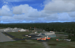
This scenery is a very accurate freeware version of Deer Lake Regional airport and sorounding area, on the west coast of the island of Newfoundland.
Designed to suit a variaty of computers, there is a setup for everyone.
There is something here for Heli, Bush, Low and slow right up to the IFR hight in the sky fliers.
Two solid years went into this scenery to try to capture as much detail as possible.
I really hope you enjoy it as much as Flight Ontario enjoyed working on it.
| Filename: | CYDF_Deer_Lake_Regional_Airport_for_Newfoundland__.zip |
| License: | Freeware |
| Added: | 2nd May 2010, 02:07:39 |
| Downloads: | 1,935 |
| Author: | Al Sibley Flight Ontario |
| Size: | 89.8 MB |
| Category: Flight Simulator X - Scenery | |
| TTPP |
|
File Description:
Piarco International Airport (IATA: POS, ICAO: TTPP) is the main airport serving Trinidad and Tobago located in Piarco, a town in northern Trinidad, about 25 km east of the capital city, Port of Spain. It is one of two international airports serving the twin isle republic. The other is located on the island of Tobago, Crown Point International Airport. The airport has one runway and helipads.
This file has the right coordenates, with the apron and characteristics of the airport. The runways and runways were resized the gates placed on correct location.
| Filename: | TTPP.zip |
| License: | Freeware |
| Added: | 1st May 2011, 00:24:55 |
| Downloads: | 2,199 |
| Author: | Anwar Gonzalez |
| Size: | 34.52 KB |
| Category: Flight Simulator X - Scenery | |
| TBPB |
|
File Description:
Grantley Adams International Airport (GAIA), (IATA: BGI, ICAO: TBPB) is found in Seawell, Christ Church on the island of Barbados. The former name of the airport was Seawell Airport before being dedicated in honour of the first Premier of Barbados, Sir Grantley Herbert Adams in 1976. The airport's timezone is GMT �4, and is located in World Area Code region #246 (by the U.S. Department of Transportation). GAIA is the only designated port of entry for persons arriving and departing by air in Barbados.
| Filename: | TBPB.zip |
| License: | Freeware |
| Added: | 5th May 2011, 21:58:21 |
| Downloads: | 1,449 |
| Author: | Anwar Gonzalez |
| Size: | 12.9 KB |
| Category: Flight Simulator X - AFCAD Files | |
| RJFR - Kitakyushu Airport - Fukuoka, Japan |
|
Images related to this file:
File Description:
Kitakyushu Airport (RJFR) is an airport in Kokuraminami-ku, Kitakyushu, Fukuoka Japan. It is built on an artificial island in the western Seto Inland Sea, 3 km (1.9 mi) away from the main body of the city. It opened on March 16, 2006 to replace the old airport in the city.
It is the fourth airport in Japan to begin operating 24 hours a day.
Using ADEx 1.67, SBuilderX 3.14, Aeronautical maps and Google Earth this new airport was built from scratch and is on par with today's appearence.
| Filename: | RJFR__Kitakyushu_Airport__Fukuoka_Japan.zip |
| License: | Freeware |
| Added: | 10th February 2016, 14:36:49 |
| Downloads: | 751 |
| Author: | Menno C. Robert |
| Size: | 2.44 MB |
| Category: Flight Simulator 2004 - Scenery | |
| French Polynesia Tuamotu Archipelago 2006 Part A |
|
Images related to this file:
File Description:
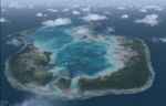
These files improve specific scenerys (Tuamotu Archipelago) of FS2004.
The archiperago scattered in the northeast of Tahiti island is composed of 78 islands.
I reproduced the 55 islands in the archipelago as add-on senery.
They are islands like a beautiful necklace sprinkled in the tropical ocean.
Tuamotu2006A includes the islands from Mataiva (the west edge of the archipelago)
to 144 West of the whole archipelago because of the file size.
When the "Tuamotu2006B" (fpta2k6b.zip) scenery is installed together with this Tuamotu2006A,
the huge Tuamotu Archipelago including all of "The Chain Islands" will appear.
| Filename: | French_Polynesia_Tuamotu_Archipelago_2006_Part_A.zip |
| License: | Freeware, limited distribution |
| Added: | 3rd December 2011, 23:53:28 |
| Downloads: | 8,533 |
| Author: | Kazuo Kawamura |
| Size: | 93.63 MB |
| Category: Flight Simulator X - Scenery | |
| FSX Scenery Only Iceland Airports Update 2023 |
|
Images related to this file:
File Description:
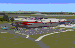
Published first in 2015 with over 11,000 downloads, I think it time to update since so many changes
have occurred around Keflavik and Reykjavik. This scenery offers extensive revisions to Keflavik airport
with a new terminal with transparent windows and interior, new passenger and cargo aprons, control tower,
and more. A totally new scenery of Vestmannaeyjar island and airport with harbor, volcanoes, ferries, and
two working lighthouses is included. Fagradasfjall volcano is now active and spewing fire and lava north
of Keflavik.Some free downloadable libraries required. This scenery REPLACES the old version.
by Dan French
| Filename: | FSX_Scenery_Only_Iceland_Airports_Update_2023.zip |
| License: | Freeware, limited distribution |
| Added: | 12th October 2023, 15:26:42 |
| Downloads: | 529 |
| Author: | Dan French |
| Size: | 12.49 MB |
| Category: Flight Simulator 2004 - Scenery | |
| Tengah Air Base Singapore (WSAT) |
|
File Description:
FS2004 Scenery — Tengah AB (WSAT), Singapore. Tengah Air Base is located on the tiny Island nation of Singapore and is home to two of its F-16 Fighting Falcons Squadrons, its E-2C Hawkeyes and a large number of UAVs. This scenery was created using RWY12 Objects. Users must have RWY12 object Libraries installed to see any objects. Included in this package are two photo-real AFCADS. The first, (WSAT) for the main base, and a second, (WSAU) for the Helicopter Base just to the west of the main runway.
| Filename: | Tengah_Air_Base_Singapore_WSAT.zip |
| License: | Freeware |
| Added: | 7th December 2008, 22:15:18 |
| Downloads: | 1,358 |
| Author: | Jacob Gibson |
| Size: | 333.18 KB |
| Category: Flight Simulator 2004 - Scenery | |
| PAAK - Atka Airport - Aleutian Islands, Alaska, USA |
|
Images related to this file:
File Description:
Atka is near the western end of the Aleutian chain of islands in Alaska, around 100 miles east of Adak and 330 miles west of Dutch Harbor. The small town (population around 60 now, down from 90 only 5 years ago; so quickly?) is reliant on fishing. The airport is a mile or so north of the town on the east coast of the island, with a single runway of 4,500 feet of asphalt, and there are scheduled flights by Grant Aviation from Dutch Harbor (included in the AI posted with Adak).
| Filename: | PAAK__Atka_Airport__Aleutian_Islands_Alaska_USA.zip |
| License: | Freeware, limited distribution |
| Added: | 17th January 2015, 19:08:38 |
| Downloads: | 268 |
| Author: | Roger Wensley |
| Size: | 2.55 MB |
| Category: Flight Simulator 2004 - Scenery | |
| Edinburgh Island, FOX-2, Horton River, Igloolik, & Kimmirut, adapted for the FSGenesis 76m North Canada Terrain Mesh |
|
Images related to this file:
File Description:
These are replacement bgl's to convert five northern Canada fields for use with the FSGenesis 76m terrain mesh for northern Canada. The five are Edinburgh Island CWEI, the FOX-2 DEW line station, Horton River CWHR, Igloolik CYGT, and Kimmirut CYLC. These are not stand-alone, and the presumption is that you have already downloaded and installed the previously posted sceneries. This installation consists solely of replacing the existing scenery bgl's with the new. There will be further posts of northern airfields in groups of five, alphabetically, and observations regarding the amendments and any further corrections that are required would be welcomed.
| Filename: | Edinburgh_Island_FOX2_Horton_River_Igloolik__Kimmi.zip |
| License: | Freeware, limited distribution |
| Added: | 10th September 2017, 19:29:57 |
| Downloads: | 86 |
| Author: | Roger Wensley |
| Size: | 3.55 MB |
© 2001-2026 AVSIM Online
All Rights Reserved
Privacy Policy |