
Where Flight Simulation Enthusiasts Gather from Around the World!
AVSIM Library - Search Results

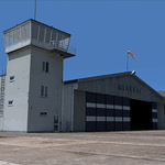
| Category: Flight Simulator X - Scenery | |
| EPGO Goraszka 2010 - The Airshow Challenge |

|
Images related to this file:
File Description:
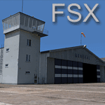
EPGO Goraszka 2010 - The Airshow Challenge is a freeware, extremely detailed scenery of a general aviation airport located 12nm (20km) south-east of Warsaw downtown and Warsaw Frederic Chopin International Airport, Poland. EPGO Goraszka airfield was built in 1994 and currently belongs to General Aviation company, which offers aero-taxi flights, air transport and special flights (air photo, patrol) and airport services. The airport has a 800m-long runway and a lightened helipad, which can be used by helicopters up to 5700kg weight. General Aviation's fleet includes Antonov AN-2, PZL-104 Wilga 80, Bell 407 and 427. Since 1996 the International Air Picnic Goraszka is organized every year by "Polish Eagles" Foundation created on initiative of Zbigniew Niemczycki.
The scenery is equipped with an automatic installer. Currently we support a safe, manual way of adding new sceneries to Scenery Library in Flight Simulator. This is just one thing users need to do for themselves. Detailed instructions will be given during the installation process.
Scenery features:
-Compatible with FSX only
-Highest level of accuracy in geographic positioning, modelling and texturing
-Incredibly high quality photoreal textures of all airport buildings. Textures are based on over 300 real world -photographs made for this project.
-Hundrieds of 3D objects like tents, exhibitions, airport buildings and surrounding buildings
-Life in the airport: people and cars will enchance your feelings
-AI traffic, animations and effects, designed specifically for FSX
-Some buildings include interior (control tower)
-High quality aerial photos of the airport surrondings (5 seasons + night) with autogen and water mask
-Ultra high quality aerial photos of the airport (with seasons)
-Plain airport scenery with no airshow objects available too (details in the manual)
-Product includes manual and airport charts in PDF format
EPGO Goraszka 2010 - The Airshow Challenge scenery is compatible with almost every payware add-on, including Ultimate Terrain Eastern Europe and Warsaw Photo Scenery by Simdesign. Scenery by Drzewiecki Design - www.drzewiecki-design.net .
| Filename: | EPGO_Goraszka_2010__The_Airshow_Challenge.zip |
| License: | Freeware |
| Added: | 16th July 2010, 12:31:42 |
| Downloads: | 4,712 |
| Author: | Drzewiecki Design - Stanislaw Drzewiecki, Jakub Paczek |
| Size: | 237.18 MB |
| Category: Flight Simulator 2004 - Scenery | |
| 8AK7 - Bullen Point - Alaska North Slope 7 |
|
Images related to this file:
File Description:
The town of Barrow is in the far north of Alaska, and these are coastal villages or radar installations to the west, south, and now east of Barrow. There will be further additions. Bullen Point is a DEW station Air Force base 240 miles east of Barrow and 75 miles east of Oliktok. The runway is just under 4,000 feet of gravel and aligned 05-23; this is approximately at right angles to the default FS9 alignment and how that came about is something I doubt Bill Gates could explain. Most of the DEW buildings have now been removed (including the large hangar, which is unusual) but as I had a layout I made the whole site as it was originally, way back in the days when the north slope was still a wilderness. The AI is one day a C-130, on another a Cessna, and on a third a DC3. When I started this North Slope series it was my intention to create the full monty and make all the oil and gas installations and Deadhorse airport etc. I have come to realise that the oil side is impossible to make. There is so much of it and each bit is as time consuming as Heathrow while the actual airfields are more like Rockcliffe CYRO, so a lot of effort for what is just background to an adjoining airfield. But at the same time, if I make the new airstrips it is impossible NOT to make the oil installations as they are the dominating feature. So no new airstrips, and this is going to be just the 1960's or 1970's, when the oil business was only exploratory and the airfields were for villages or DEW stations, and Harmon Helmerick had his dirt strip on the Colville River estuary and was guiding hunters and fishermen and had just started to help out Sinclair Oil with oil exploration in 1966. Read his book. Download my previous post of his field.
| Filename: | 8AK7__Bullen_Point__Alaska_North_Slope_7.zip |
| License: | Freeware, limited distribution |
| Added: | 15th July 2016, 17:46:54 |
| Downloads: | 277 |
| Author: | Roger Wensley |
| Size: | 2.5 MB |
| Category: Flight Simulator X - Aircraft Repaints, Textures and Modifications | |
| Boeing B-17G 91st BG (LL-E) "Shoo shoo shoo baby" restored |
|
Images related to this file:
File Description:
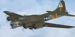
This folder contains a repaint for the A2A WoP2 B-17G in the colors of B-17G-35-BO 42-32076, the former "Shoo shoo shoo baby". In 1968, the ancestry of F-BGSH, an old B-17 languishing in derelict state on Creil Airfield in France, was discovered by the Australian aviation historian Steve Birdsall, who notified the USAF museum that this was a combat veteran that had flown operational missions, in contrast to most other surviving B-17's. Following negotiations, the B-17 was donated to the US by the French Government. Interestingly, its Swedish heritage attracted interest from Sweden as well, but nothing came of this. The aircraft was disassembled at Creil and trucked to Frankfurt and flown to the US in 1972, where it arrived, packed in 27 crates. No plans or funds for restoration were present at the time, but in 1977, Mike Leiston, a technician at Dover AFB contacted the museum about the possibility of restoring one of the museum's aircraft by volunteers at Dover AFB. With project approved, 42-32076 was transported to Dover, with the aim of restoring it to a stock wartime B-17G. Upon arrival, Paul McDuffee, who had flown her for 13 missions, was present, and the reunion was clearly an emotional one as he commented "I've just got to go over and kiss her", which he did.
The restoration continued to 1988,and after some 60.000 ma hours, "Shoo shoo shoo baby"took to the skies again for the first time on 11 september. On 14 october 1988, she flew for the last time, to the USAF museum near Dayton, Ohio, where she can still be seen. The main difference with her wartime looks is the fact that she currently sports an olive drab camouflage paint, which was necessary due to all the metal work needed to bring her back to a stock B-17G condition. Repaint by Jan Kees Blom, based on the paintkit by A2A.
| Filename: | Boeing_B17G_91st_BG_LLE_Shoo_shoo_shoo_baby_restor.zip |
| License: | Freeware |
| Added: | 7th October 2019, 18:23:08 |
| Downloads: | 144 |
| Author: | Jan Kees Blom |
| Size: | 11.57 MB |
| Category: Flight Simulator 2004 - Scenery | |
| EPGO Goraszka 2010 - The Airshow Challenge |
|
Images related to this file:
File Description:
EPGO Goraszka 2010 - The Airshow Challenge is a freeware, extremely detailed scenery of a general aviation airport located 12nm (20km) south-east of Warsaw downtown and Warsaw Frederic Chopin International Airport, Poland. EPGO Goraszka airfield was built in 1994 and currently belongs to a General Aviation company, which offers aero-taxi flights, air transport and special flights (air photo, patrol) and airport services. The airport has a 800m-long runway and a lightened helipad, which can be used by helicopters of up to 5700kg weight. General Aviation's fleet includes Antonov AN-2, PZL-104 Wilga 80, Bell 407 and 427. Since 1996 the International Air Picnic Goraszka is organized every year by the "Polish Eagles" foundation created on initiative of Zbigniew Niemczycki.
The scenery is equipped with an automatic installer. Currently we support a safe, manual way of adding new sceneries to the Scenery Library in Flight Simulator. This is just one thing users need to do for themselves. Detailed instructions will be given during the installation process.
Scenery features:
-Compatible with FS2004 only
-Highest level of accuracy in geographic positioning, modeling and texturing
-Incredibly high quality photoreal textures of all airport buildings. Textures are based on over 300 real world -photographs made for this project.
-Hundreds of 3D objects like tents, exhibitions, airport buildings and surrounding buildings
-Life in the airport: people and cars will enhance your feelings
-AI traffic, animations and effects, designed specifically for FS2004
-Some buildings include interior (control tower)
-High quality aerial photos of the airport surroundings (5 seasons + night) with autogen and water mask
-Ultra high quality aerial photos of the airport (with seasons)
-Plain airport scenery with no airshow objects available too (details in the manual)
-Product includes manual and airport charts in PDF format
EPGO Goraszka 2010 - The Airshow Challenge scenery is compatible with almost every payware add-on, including Ultimate Terrain Eastern Europe and Warsaw Photo Scenery by Simdesign.
Scenery by Drzewiecki Design - www.drzewiecki-design.net
| Filename: | EPGO_Goraszka_2010__The_Airshow_Challenge.zip |
| License: | Freeware |
| Added: | 14th July 2010, 09:49:07 |
| Downloads: | 3,751 |
| Author: | Drzewiecki Design - Stanislaw Drzewiecki, Jakub Paczek |
| Size: | 132.03 MB |
| Category: Flight Simulator 2004 - Scenery | |
| Seward PAWD in Alaska V2 plus 6AK5 |
|
Images related to this file:
File Description:
This is V2, the combined original and also V1. If you have already installed V1 then you do not need this. The town of Seward (population around 2,700) is on the east coast of the Kenai Peninsula, 70 miles east of Kenai town and also 70 miles southeast of Anchorage, amid mountains and glaciers at the northern end of the 20 mile long and fjord-like Resurrection Bay. It is also at the southern end of both the Alaska Railway and the Seward Highway, and has a sheltered dock for freight and also for cruise liners. Passengers from the liners can enjoy local attractions (dog sledging on a glacier?) and also easily continue further north by bus or train to Anchorage or to other tourist attractions such as Denali. The airport is next to the port and the town, with two runways aligned (in FS9, not taking account of the recently wandering magnetic north) 15-33 and 12-30, both asphalt and 2,100 and 4,200 feet long respectively. Only 12-30 (and its taxiways) is lit, with VASI on 30. There are no regularly scheduled flights to Seward; with buses and trains running direct from Anchorage there is no money to be made. There are some charter flights coordinated with cruise liners, and some freight flights, the very occasional visit by the Coastguard, but most flights are GA, air taxi,or short scenery-viewing trips for summer tourists. In a mountainous area the only sure thing about the behaviour of AI aircraft is that it is unpredictable but often involves a mountain; nothing to be done about it. At Seward there is also marine AI from and to the port, in the shape of a cruise liner and an Alaskan ferry, but the latter only if you have Holger Sandmann's Alaska scenery installed. Also included with this is a correction for Fire Island 6AK5, near Anchorage, that takes the airfield out of the water; this is something I have meant to do for the last 5 years.
| Filename: | Seward_PAWD_in_Alaska_V2_plus_6AK5.zip |
| License: | Freeware, limited distribution |
| Added: | 19th January 2016, 18:27:26 |
| Downloads: | 591 |
| Author: | Roger Wensley |
| Size: | 12.47 MB |
| Category: Flight Simulator 2004 - Scenery | |
| Edson CYET in Alberta, Canada |
|
Images related to this file:
File Description:
Edson is 120 miles west of Edmonton in Alberta, on Highway 16. It was originally named Heatherwood, but that was changed to honour the vice president of the Grand Trunk Pacific Railway when it was made the local railway centre. It thrived, and when Highway 16 was upgraded it thrived even more. Coal mining and industry connected with timber are the main employers of a population of around 8,500. The airport is at the western edge of the town at 3,041 feet asl, with a single lit runway 6,000 feet long and 100 feet wide aligned 07-25, with displaced thresholds and VASI at each end. The two joined aprons are at the eastern end of the airfield, with fire fighting chemical tanks beside the western one which is reserved in the summer months for the Lockheed Electra Air Spray planes; these are included in the AI. The eastern apron is for visiting charters and GA planes, next to a small terminal building. There is further parking on the grass for resident planes next to a large gravel car parking area and clubhouse. As the Air Spray planes would not be fighting fires in the winter there are in fact two editions of the AI, one for the summer fire fighting season and the other for the winter freeze. Use whichever one is appropriate for your flight time; I never strayed far from Ottawa in the winter so for me it is the summer one only. While making this I came across something new in the shape of some incorrectly installed edge lights in the stock fs9 version that refused to be deleted. There is still an "Edson TOP" folder which would normally be used to delete all unwanted taxiway edge lights, but in this case it deletes only some of them. Apologies, but there is nothing more that I can do and so I suggest you use this in daylight only.
| Filename: | Edson_CYET_in_Alberta_Canada.zip |
| License: | Freeware, limited distribution |
| Added: | 10th February 2019, 23:59:04 |
| Downloads: | 147 |
| Author: | Roger Wensley |
| Size: | 7.14 MB |
| Category: Flight Simulator X - Scenery | |
| RAF Polebrook |
|
File Description:
On June 28, 1942, RAF Polebrook was officially turned over to the USAAF and the airbase became the base of the 97th Bombardment Group, the first USAAF heavy bomber organization to arrive in the UK. It was designated USAAF Station 110.
The 97th BG was assigned to the 1st Combat Wing, at RAF Bassingbourn. It's operational squadrons were divided between Polebrook and RAF Grafton Underwood:
340th Bomb Squadron (RAF Polebrook)
341st Bomb Squadron (RAF Polebrook)
The 97th BG conducted a total of 14 missions from Polebrook, attacking airfields, marshalling yards, industries, naval installations, and other targets in France and the Low Countries.
The group sortied 247 aircraft, dropped 395 tons of bombs on Nazi-controlled territory, and lost 14 aircraft. On October 21, 1942, the 97th Bomb Group was transferred to the Twelfth Air Force in the Mediterranean theater and Polebrook was unoccupied until April 1943.
351st Bombardment Group (Heavy)
On April 15, 1943, the 351st Bomb Group arrived at RAF Polebrook. It was assigned to the 94th Combat Wing, also at Polebrook. The group tail code was a "Triangle J". It's operational squadrons were:
508th Bomb Squadron (YB)
509th Bomb Squadron (RQ)
510th Bomb Squadron (TU)
511th Bomb Squadron (DS)
Boeing B-17G-85-BO Flying Fortress, Serial 43-38465 of the 510th Bomb Squadron. This aircraft survived the war and returned to USA on 8 June 1945
Douglas-Long Beach B-17G-30-DL Flying Fortress Serial 43-38116 of the 509th Bomb Squadron.The 351st's first completed combat mission took place on May 14, 1943, when 18 B-17's targeted a German Luftwaffe airfield at Kortrijk, Belgium. As the war progressed, the 351st operated primarily against strategic objectives in Germany, striking such targets as ball-bearing plants at Schweinfurt, communications at Mayen, marshalling yards at Koblenz, a locomotive and tank factory at Hannover, industries at Berlin, bridges at Cologne, an armaments factory at Mannheim, and oil refineries at Hamburg.This is for FSX and you will need to have Ted Andrews's RAF Hangars Library and his other great RAF Buildings. They can
be found on AVSIM. Search the FSX section for "Ted Andrews" - you'll find loads of his scenery object files for
RAF airfields. Follow his instructions on how to install them.
| Filename: | RAF_Polebrook.zip |
| License: | Freeware |
| Added: | 21st January 2009, 13:27:45 |
| Downloads: | 1,058 |
| Author: | Scott Berge |
| Size: | 15.01 KB |
| Category: Flight Simulator 2004 - Scenery | |
| Bella Coola CYBD in British Columbia, Canada |
|
Images related to this file:
File Description:
Bella Coola is in one of the deep east-west fjords amid the Coastal Range on the coast of BC, approximately mid way between Vancouver and the Alaskan border and some 70 miles inland from the open ocean. The town of Bella Coola has a small population of around 150, while the population of the whole Bella Coola Valley is around 2,000. The valley is warmer in both summer and winter than the surrounding area, and tourism flourishes along with forestry, fishing, and local government administration. Although there is road access, the ferry service is the main connection to larger coastal towns or cities such as Vancouver. The airport, 7 miles east of the town, is connected by daily Pacific Coastal flights to Vancouver and Anahim Lake (to the east). The asphalt runway is 4,200 feet long and aligned 04-22 in FS9 (by 2010 this had changed to 05-23 in reality) and is without lighting of any sort, so it is restricted to daylight hours only. At the eastern end is the terminal building and in the middle the West Coast Helicopter hangar, which has a large fenced paddock-like enclosure in front of it. The helicopters hop over the three feet high fence as they "taxi" to the apron in front of the hanger (but not in FS9!). Between the two there are four other company hangars spread out along the roadway beside the fence. I have never seen the airfield in Summer, and I have not attempted to replicate the apron as it now shows in Google Earth. The screenshots show the main and overwhelming feature of Bella Coola, the large valley amid the steep mountains. This terrain has an inevitable effect on the ai, in that you will never see a plane land as it hits solid rock before it makes it to the runway. You will, however, see them take off. Pacific Coastal currently flies Beechcraft 1900's to Bella Coola; I have used the Saab 340 which I have seen there some years ago and which I prefer.
| Filename: | Bella_Coola_CYBD_in_British_Columbia_Canada.zip |
| License: | Freeware, limited distribution |
| Added: | 25th October 2018, 17:57:06 |
| Downloads: | 282 |
| Author: | Roger Wensley |
| Size: | 14.57 MB |
| Category: Flight Simulator 2004 - Scenery | |
| Port Hardy CYZT in British Columbia, Canada |
|
Images related to this file:
File Description:
Port Hardy airport is on the coast of Vancouver Island in BC, at the far northern end and 5 miles east of the town. The town and the airport are both gateways to local touristic attractions such as Cape Scott Provincial Park, the North Coast and BC Marine Trails, and kayaking, caving, surfing, fishing, camping, and scuba diving (and I discovered just how big orca are). Fishing, logging, and mining have been important and to an extent still are for the town population of just over 4,000. The airport, along with the ferries, connects Port Hardy to the rest of the west coast with Pacific Coastal Saab 340 or Beechcraft 1900C flights to and from Vancouver at least twice a day. There are also Grumman Goose amphibious flights to local float bases such as Port McNeill, Alert Bay, Whaletown, Surge Narrows, Echo Bay, and Minstrel Island. These are all included in the AI and previously posted. There are three runways: 11-29 of 5,000 feet with ILS on 11 and righthand circuits on 29, 07-25 of 4,000 feet with righthand circuits on 25, and 16-34 with a much shortened 3,500 feet on 34 due to a displaced threshold. There is a control tower but it is not manned 24 hours a day; a "mandatory frequency" (MF for short and a Canadian invention) is used by the tower when it is manned, and when there is no tower response the aircraft continues to announce intentions and position. Something I have been meaning to explain to those who query it, is that in real life as well as in FS9 helicopters at a mixed use airport or airfield will act as if they are planes and join downwind, turn on base and then finals, "land" along the runway and then use the taxiway to the parking. This means all aircraft are doing the same thing and an orderly queue avoids collisions. This is one of a series connected in some way with Pacific Coastal airline destinations, the first being Bella Coola. There is AI available for Pacific Coastal online.
| Filename: | Port_Hardy_CYZT_in_British_Columbia_Canada.zip |
| License: | Freeware, limited distribution |
| Added: | 11th November 2018, 16:48:50 |
| Downloads: | 233 |
| Author: | Roger Wensley |
| Size: | 19.26 MB |
| Category: Flight Simulator 2004 - Scenery | |
| Cordova Smith PACV & Municipal CKU in Alaska US |
|
Images related to this file:
File Description:
Cordova is on the south coast of Alaska, around 150 miles east of Anchorage and 45 miles south of Valdez. The town is mainly built on a small but relatively flat area between the east side of Prince William Sound and Eyak Lake, and has a population of around 2,350 in 2010, the approximate date of this scenery.
The Municipal Airfield CKU is on the north side of Eyak Lake to the east of Cordova, with the runway that is 1,800 feet of unlit gravel squeezed between the lake and the road that runs around the lake. The hangars and parking aprons are reached by taxiing across, and to some extent along, the road. Float planes are also taken from the lake to an apron to the west of the runway.
Cordova Airport PACV (named in the real world "Merle K. (Mudhole) Smith", and I will leave you to research this) is known as Cordova Smith in FS9 and is 10 miles to the east of the town on relatively flat ground between mountains to the north and the sea to the south. The runway is 8,080 feet of lit asphalt aligned 09-27 with ILS on runway 27 and VASI on both ends. The aprons are to the north side of the runway and are reached by back-taxiing; there are no taxiways parallel to the runway. The main apron serves Alaska Air via the western of two taxiways. The GA parking and hangars are mainly reached by using the eastern taxiway, though there is in fact a connecting taxiway between the two (for GA, but definitely not for airliner use). The taxiway further to the west serves the separated Alaska Coastguard apron and hangar, which is mainly for helicopter use. There is a nominally grass runway 1,900 feet long and aligned 16-34 to the south of the main runway; in fact it appears to be more gravel than grass. I have left this inactive as otherwise AI Alaska Air planes would be attempting to use this when the wind made it seem like a good idea.
The AI includes Alaska Air (twice a day) and also Coastguard helicopters, along with GA.
| Filename: | Cordova_Smith_PACV__Municipal_CKU_in_Alaska_US.zip |
| License: | Freeware, limited distribution |
| Added: | 22nd January 2022, 21:53:03 |
| Downloads: | 145 |
| Author: | Roger Wensley |
| Size: | 16.93 MB |
© 2001-2026 AVSIM Online
All Rights Reserved
Privacy Policy |