
Where Flight Simulation Enthusiasts Gather from Around the World!
AVSIM Library - Search Results

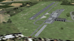
| Category: Flight Simulator 2004 - Scenery | |
| PIK2004 |

|
File Description:
FS2004 - (Glasgow)Prestwick International Airport.
This whole package is intended to compliment the comprehensive scenery for Scotland provided by the Scotflight Commercial Product, whilst at the same time being fully compatible with default scenery also.
This Fs2004 only compatible scenery gives highly detailed scenery for Prestwick Airport and it's immediate surrounds.
Prestwick Airport is a hub for the low-cost carrier Ryanair providing flights to many European destinations. Other holiday charter flights operate from the airport and there is a busy cargo terminal. Also adjacent to the airfield is the BAE Systems factory ( formerly Scottish Aviation) and extensive detailed scenery for this site is included.
The ground elements of the scenery are drawn with Lee Swordy's excellent Afcad program. The same file also adds AI traffic and accurately placed gates and parking spots. Included is the recently added FlightCentre, with AI traffic movements, the new Ryanair Service Hangar and new Business Park.
All added buildings are custom made, many with photo-texturing. The scenery has taxiway signs, active wigwags and full night lighting and a few static aircraft, discreetly placed.
A stretch of redrawn accurate coastline is included allowing the addition of the sandy beaches on the approach to Runway 13.
The two renowned championship golf courses of Royal Troon and Old Prestwick also feature on the seaward approach plus further golf courses in the towns of Prestwick and Ayr.
A local replacement road system covering the airport surrounds and the towns of Prestwick and Ayr is also included and this together with the replacement coastline should be compatible with any of the new Coastline and Roads products now available.
| Filename: | PIK2004.zip |
| License: | Freeware, limited distribution |
| Added: | 27th August 2005, 19:32:32 |
| Downloads: | 24,603 |
| Author: | Iain Gallacher-Scotflight Scenery |
| Size: | 8.07 MB |
| Category: Flight Simulator 2004 - Scenery | |
| Bethel: St Mary's area airfields in southwest Alaska close to the Yukon River |
|
Images related to this file:
File Description:
This presumes you have already installed Bethel PABE and Bethel Local Airfields. In the Yukon River area of Alaska to the north of Bethel there are small villages, served by flights from both Bethel and the nearer St Mary's PASM. St Mary's has a gravel runway like the other villages, but has a larger population and airport services including maintenance and fuel. This, plus the saving of an average one hundred miles of flying by a Cessna 205 when compared with flights from Bethel, means it acts as a distribution centre fed from Bethel by larger aircraft. Go to "http://vfrmap.com/" for free vfr maps of the area (see the attached). The ten village airfields included here are all to the north and west of St Mary's: Hooper Bay PAHP, Chevak VAK, Cape Romanzof PACZ (closed air force field servicing a radar station), Scammon Bay SCM, Sheldon Point SXP, Alakanuk AUK, Emmonak PAEM, Kotlik 2A9, Mountain Village MOU, and of course St Mary's PASM itself. With these airfields not everything is as it appears to be. For instance, Hooper Bay is not a new and modernised airfield, despite the asphalt runway and apron; the current version has dispensed with the aging asphalt and gone back to gravel. I have tended to go for the 2005 or so versions, which sometimes means a small runway amid or close to the housing; Kotlik was an early renewal for reasons of safety as much as anything else and has had (since 2003?) a new and longer runway located outside of the town. The second batch of airfields will be to the east of St Mary's.
| Filename: | Bethel_St_Marys_area_airfields_in_southwest_Alaska.zip |
| License: | Freeware, limited distribution |
| Added: | 29th April 2019, 17:07:24 |
| Downloads: | 225 |
| Author: | Roger Wensley |
| Size: | 11.53 MB |
| Category: Prepar3D V1-4 - Aircraft Repaints, Textures and Modifications | |
| North American P-51D 52nd FG (WD-M) 'Pendaja / Miss Ruth' |
|
Images related to this file:
File Description:

This folder contains a repaint for the A2A WoP3 P-51D Mustang (with AccuSim), in the colors of P-51D-5-NA 44-13287 WD-M, which was the aircraft assigned to Lt William Parent of the 4th FS/ 52nd FG, based in Italy. On the 1st of September 1944 however, it was being flown by Major Wyatt P. Exum during an escort mission to Hungary. It was Maj. Exum's first operational mission nin the ETO. On the way back from the mission, the squadron strafed an airfield, before spotting a moving train. Lts Strout and Wilson attacked the train, and as a result of Lt Wilson's attack, the engine blew up while he was overflying it, damaging his cooling system and setting the engine on fire. The fire quickly blew out, and Lt Wilson decided to make an belly landing in a recently plowed field. Over the radio, he heard Maj Wyatt Exum transmit "I'll be down to get you, Charlie!" and indeed he landed close to Lt Wilson's aircraft. Lt Wilson managed to turn Maj Exum's aircraft, as his tail wheel had become stuck in a rut in the field, and both men tried to squeeze into the cockpit. Meanwhile, men on horseback were approaching, shooting several holes in the aircraft. While Lt Wilson shot back with his .45, Major Exum gunned the engine, and they managed to take off with Lt Wilson half outside the cockpit with his .45. They flew the 400 miles back to Madna in Italy on their last fuel, and landed with other Mustangs landing from the other side. Major Exum received the Silver Star for this action, as well as from the undying gratitude and admiration from Lt Wilson Repaint by Jan Kees Blom, based on the A2A paintkit.
| Filename: | North_American_P51D_52nd_FG_WDM_Pendaja__Miss_Ruth.zip |
| License: | Freeware |
| Added: | 4th November 2018, 17:24:47 |
| Downloads: | 65 |
| Author: | Jan Kees Blom |
| Size: | 11.83 MB |
| Category: Flight Simulator 2004 - Scenery | |
| 9A8 - Ugashik, PAII - Egegik, AK96 - Bartletts, AK36 - Coffee Point , Alaska, USA |
|
Images related to this file:
File Description:
All four of these depend heavily on fishing but two of them only spring into existance during the salmon catching-and-canning season. Grant Air run scheduled flights to the two permanent settlements, and there are irregular scheduled flights and charters to the others according to demand. Ugashik is a permanent settlement 60 miles northeast of Port Heiden, stretched out along the east bank of the Ugashik River. There are two canneries, one old and collapsing and the other newer and functioning. The population is given as 12, though during the season this increases significantly. The (newer) airfield is at the northern end of the village with a gravel runway 3,500 feet long aligned 06-24. Egegik is the second permanent settlement, 45 miles north of Ugashik and 40 miles southwest of King Salmon, on the east bank of the Egegik River. The town is on a corner of land, with a population of around 110 and two operating canneries. The airport is a mile and a half south of the town with two gravel runways, 12-30 at just under 5,600 feet and 03-21 with 1,500 feet; both are lit. On the other side of the Egegik River are more canneries and two airfields, both of which have two runways but are otherwise entirely without facilities or luxuries such as lights. They are called Bartletts (named for the cannery it serves) and Coffee Point (named for the location). The shacks of the seasonal fishermen are strung out along the coast and a lot of the salmon fishing is by net, laid by a small boat and later pulled ashore for emptying. Only one cannery on the west shore has a docking facility for unloading boat-caught fish.
| Filename: | 9A8__Ugashik_PAII__Egegik_AK96__Bartletts_AK36__Co.zip |
| License: | Freeware, limited distribution |
| Added: | 3rd April 2015, 18:06:49 |
| Downloads: | 1,134 |
| Author: | Roger Wensley |
| Size: | 4.98 MB |
| Category: Flight Simulator 2004 - Scenery | |
| Airstrips of North-West Europe |
|
Images related to this file:
File Description:
The sales blurb for FS2004 announced the inclusion of over 23,000 airfields ... unfortunately a significant number of those consisted of little or nothing more than a runway on a flatten with a rectangular background polygon.
To enable the addition of an amount of lightweight GA AI traffic, without overloading those airfields that were designed with parking spaces and taxi-ways, (and are probably already busy), I herewith include over 140 small sceneries, of mostly default airfields, from NW France, up the English Channel and the North Sea coast through Belgium, the Netherlands and NW Germany to Denmark, all with added taxiways and parking spots, aprons, generic buildings and background polygons as appropriate, to enable AI traffic to be generated without interrupting things at the more major airports.
A few of the French airfields are "new", not included originally with FS2004, and a couple have been updated to suit more recent developments :- for example, LFES "Scaer Guiscriff" is now LFES "Bretagne Atlantique", LFOR "Chartres Champhol" is now LFOR "Chartres Metropole", EHSE "Seppe" is now EHSE "Breda International" and EKVH "Vesthimmerlands" was previously EKVH "Aars".
There's no photo-realism here, just a selection of basic 'generic' buildings, more or less accurately sized and placed to reflect the airfield layout as seen on on-line satellite imagery and aerial photography. These buildings have minimal effect on frame-rates, so are ideal for this kind of job.
The airfields are aligned as well as possible with the roads etc. in UT Europe and the Genesis Europe mesh, but should mostly be fine in a default installation or other configuration.
Please read the rest of this "waffle" in the included text file ... it might save some confusion ;)
Enjoy :)
| Filename: | Airstrips_of_NorthWest_Europe.zip |
| License: | Freeware |
| Added: | 14th June 2024, 13:44:58 |
| Downloads: | 283 |
| Author: | Chris Eve |
| Size: | 9.95 MB |
| Category: Flight Simulator 2004 - Scenery | |
| CPR5 - Woodstock - Ontario, Canada |
|
Images related to this file:
File Description:
This is the first of a south Ontario series. Woodstock is a town with a population of around 38,000, located 50 miles west of Lake Ontario. The airfield is 3 miles west of the town, with a single grass runway just over 3,000 feet long and 100 plus feet wide, aligned 05/23 in FS9 (in fact it is now 06/24 due to the magnetic north wandering off during the last 10 years). There have been at different times varying amounts of gravel mixed in with the grass on both runway and taxiway; the majority surface by far is grass and I have left it all as such, as there is no visually convincing way to mix the two without unreal sharp edges. The apron is on the northern side of the runway, and is now modified in shape to maximise the area available for crops. There are 10 "T" hangars and a small clubhouse in a single long building. There is no fuel, runway lighting, or taxiway or apron lights so usage is effectively restricted to daylight hours. To the east of CPR5 and on the edge of the town is a private airstrip with 2,800 feet of asphalt runway; I have added this as a visual reference, along with several large grain silos on the other side of the road. Hidden in plain sight amid the surrounding farmland, the first sighting of CPR5 is actually always of the adjacent and far more visible buildings just to the east of the apron, which are owned by a company that deals with everything to do with boats, up to and including fishing gear. These have been included. As ditches cannot be effectively duplicated in FS9 I have included some fences which do not exist in real life, to give some needed visual clues.
| Filename: | CPR5__Woodstock__Ontario_Canada.zip |
| License: | Freeware, limited distribution |
| Added: | 8th July 2015, 13:36:05 |
| Downloads: | 184 |
| Author: | Roger Wensley |
| Size: | 5.57 MB |
| Category: Flight Simulator 2004 - Scenery | |
| Tuktoyaktuk CYUB in Northwest Territories, Canada |
|
Images related to this file:
File Description:
Tuktoyaktuk is on the northern coast of Canada, 70 miles north of Inuvik and to the east of the Mackenzie River delta. It has a population of around 900 and because of its natural harbour is a centre for oil exploration activity on the surrounding land and on the Beaufort Sea, with sizeable but now under-used yards dating back to the peak of activity in the late 1970's. On land work is restricted to the winter half of the year, as only the freeze-up makes it possible to move on land with heavy equipment, and during the winter further supples are driven over an ice road from Inuvik up to Tuk. The ice-free summer months are used for floating equipment from Yuk along the coast on barges and then up the rivers to inland sites in preparation for the winter activity. Before the oil there was a DEW line station here, and there is still an automated station on the same site and included here, as are the yards. The airfield is on the coast close to the town and the yards, at 15' ASL. The gravel runway 09/27 is 5,000' feet long and 150' wide; both thresholds are displaced by 200', but of course there are no markings on the gravel. The large apron is on the north side at the centre of the runway and is large enough to accomodate several large planes. Inuvik revised should be installed first, now Tuk, then last of the three Sachs Harbour which has AI for Aklak Airlines flights (operated by Kenn Borek) for all three airfields. There is a separate AI file included here, featuring freight delivery by Buffalo Airways and small planes.
| Filename: | Tuktoyaktuk_CYUB_in_Northwest_Territories_Canada.zip |
| License: | Freeware, limited distribution |
| Added: | 14th May 2012, 17:19:20 |
| Downloads: | 618 |
| Author: | Roger Wensley |
| Size: | 8.99 MB |
| Category: Flight Simulator X - Aircraft Repaints, Textures and Modifications | |
| Boeing B-17G 91st BG (OR-L) "Blue Dreams" |
|
Images related to this file:
File Description:
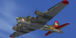
This folder contains a repaint for the A2A WoP2 B-17G in the colors of B-17G-10-DL 42-37761 OR-L "Blue Dreams" of the 323rd BS/ 91st BG, based in Bassingbourne, UK. "Blue Dreams" was assigned to Captain Ken McFarland and his crew, and was painted by Corporal Tony Starcer, with the december pin-up by Alberto varga. When the crew found out that their captain's wife was pregnant, they had Starcer paint a stork and baby below the pilots window (without McFarlane knowing), adding the name 'Mona Gail'after the birth of his daughter. The aircraft would go on to complete 29 missions with the group, before being written off due to an unfortunate oversight by another crew. Shortly after taking off for a flight to Berlin, on the 6th of March 1944, the pilot, Lt Walter Wilkinson, noticed fuel streaming from the starboard wing. He decided to land immediately, in the hope of quickly solving the problem and rejoining the mission. The nearest airfield was the 355th FG's base at Steeple Morden, close to Bassingbourne, and he decided to land there. He lined up with the runway and slowly descended the heavily laden bomber, going for a smooth as possible landing. What came was different, since the crew had forgotten to lower the landing gear, and "Blue Dreams" screeched of the runway and into the grass. The crew evacuated the wrecked aircraft as quickly as they could, but fortunately, the bombs in the bomb-bay did not explode. "Blue Dreams" would not fly again, and was salvaged the following day. The subsequent accident report revealed that the pilot had flown 8 exhaustive missions in the previous two weeks. This time nobody was hurt, but it would be a different story 10 months later, when another 91st B-17 forcelanded at Steeple Morden...
Repaint by Jan Kees Blom, based on the A2A paintkit.
| Filename: | Boeing_B17G_91st_BG_ORL_Blue_Dreams.zip |
| License: | Freeware |
| Added: | 7th October 2019, 18:19:18 |
| Downloads: | 100 |
| Author: | Jan Kees Blom |
| Size: | 17.66 MB |
| Category: Flight Simulator 2004 - Scenery | |
| Bethel area airfields in southwest Alaska close to the Yukon River |
|
Images related to this file:
File Description:
This presumes you have already installed my post of Bethel PABE. In the Yukon River area of Alaska there are a lot of small villages close together, which is unusual for Alaska. Almost all of them are on the coast or a river bank, and the local economies depend on fishing. Some are larger than others and have a fish processing plant, such as in Emmonak. This is the largest such plant and it exports prepared fish by cargo planes which fly in on a daily basis, using an extended runway. This post includes airfields to the south and west of PABE, 17 of them; some of them already included and now modified. There will be more airfields to the north and northwest of Bethel in a future post. There are revisions to Bethel to include parking spaces for Yute Air (newly included here) and extra spaces for Ryan Air. Both of these flew Cessna 205 planes into the smaller village strips from Bethel (past tense as Yute Air recently went bankrupt). The northwest area is served both from Bethel and also from St Mary's PASM, which is in the northwest and at a more economical range to the local airfields (100 miles closer than Bethel). These smaller airfields have few airfield buildings or any other creature comforts; featuring heavily are a new standard blue garage building (sometimes not yet installed) and a small and old terminal shed (that has sometimes collapsed and been removed). Go to "http://vfrmap.com/" for free vfr maps of the area, There is a pic of the local chart area included here. The screenshots are a random sample. Kipnuk PAKI is the one that appears to have a second and long grass runway; what it actually has is the ground prepared for a new and long gravel runway but which hasn't been started yet as it has taken 10 years just to prepare the ground. I have no idea why.
| Filename: | Bethel_area_airfields_in_southwest_Alaska_close_to.zip |
| License: | Freeware, limited distribution |
| Added: | 16th April 2019, 22:47:47 |
| Downloads: | 154 |
| Author: | Roger Wensley |
| Size: | 5.93 MB |
| Category: Miscellaneous Files - General Utilities | |
| Random Airport Generator |
|
Images related to this file:
File Description:
I can be contacted at [email protected] for any help required or different drive versions needed.
[ABOUT THE PROGRAM]
This program will read a text file from the route of your hard drive depending on the version you run, and select a random line and display that line. The file must be a text file named "Airports.txt". This program was designed with ease of use in mind for selecting a random airport for the Flight Sim community, though can be used for any purpose with any text file called "Airports.txt". The program will display the airport ICAO code then co-ordinates.
[ABOUT ME]
I am a 16 year old aviation enthusiast that loves flying and ATC, but hate having to choose an airport to depart from and arrive at, or to controll. This program has now removed this to make my flight more random with less decisions to make. I also like to explore areas I haven't been before, again this selects a random airport, from thousands of different ones, so exploring is inevitable.
[INSTALLATION]
The only installation required is to copy the Airports.txt file to the route of your hard drive C: or D: (for more drives e-mail me as above), then run the respective program for that drive from any folder you wish.
[ABOUT THE AIRPORTS.TXT FILE]
This file was collected from my FS2004 and contains every airport in it. Currently the program selects a line at random and displays it, whether a large international airport or small grass field. You could edit the file just to contain your favourite airports and it will NOT affect the running of the program as long as the file remains as Airports.txt. I am hoping in future versions to allow you to select a type of airfield, i.e. large, medium or small or select from runway length, though this will take a while to produce, if ever.
For now i hope everyone enjoys the program and happy flying :)
| Filename: | Random_Airport_Generator.zip |
| License: | Freeware |
| Added: | 9th June 2010, 02:41:14 |
| Downloads: | 210 |
| Author: | Alexander Aschacher |
| Size: | 254.45 KB |
© 2001-2026 AVSIM Online
All Rights Reserved
Privacy Policy |