
Where Flight Simulation Enthusiasts Gather from Around the World!
AVSIM Library - Search Results

| Category: Flight Simulator 2004 - Scenery | |
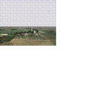
| Arviat CYEK in Nunavut, Canada |

|
Images related to this file:
File Description:
Arviat is a small town on the west coast of Hudson Bay in Nunavut, around 90 miles south of Whale Cove, 130 miles south of Rankin Inlet, and 160 miles north of Churchill. The airfield is just south of the town, and the 4,000 feet of gravel runway is aligned 149T/329T; these are true bearings and not magnetic as Arviat is just inside the Northern Domestic Airspace zone. There is 100LL fuel available in drums, with 2 hours prior notice. The visiting AI airline is Calm Air, plus a cargo delivery by Buffalo Air. As a town of 2,200 people is too large to model I have used a landclass with autogeneration. The result includes some trees, which is not realistic, but there was no way out. There is a special note in the instructions regarding Flight Ontario replacement textures and "glowing" gravel aprons.
| Filename: | Arviat_CYEK_in_Nunavut_Canada.zip |
| License: | Freeware, limited distribution |
| Added: | 6th January 2012, 16:13:45 |
| Downloads: | 506 |
| Author: | Roger Wensley |
| Size: | 2.19 MB |
| Category: Flight Simulator 2004 - Scenery | |
| Webster OFL (KNUI) for UT/USA |
|
File Description:
Webster Field is an outlying airport realted to PAX Naval Air Test Center in Maryland. According to what I have read, they use the airport mainly to test unmanned aircraft.
In a support note I saw an image of this airfield in Ultimate Terrain showing its runways extending out into the water. So I fixed it. I couldn't find much more info on it other than that on www.AirNav.com, so I've just kept the default layout for the most part. I did have to rotate the runways a bit to match the satellite photo about 10 degrees for 14/32. I kept the runway labels, however as that is how they are listed in Airnav and show up in the satellite photo. If anyone has any further info I'd be happy to add to it.
This version is meant for use with Ultimate Terrain USA.
| Filename: | Webster_OFL_KNUI_for_UTUSA.zip |
| License: | Freeware |
| Added: | 23rd February 2006, 05:20:49 |
| Downloads: | 377 |
| Author: | Thomas Perry |
| Size: | 218.88 KB |
| Category: Flight Simulator 2004 - Scenery | |
| Tillsonburg CNQ4 in Ontario Canada REPLACEMENT |
|
File Description:
This is a replacement (though complete in itself) for my original Tillsonburg post with the corrected office building included. Tillsonburg is a small town in southwest Ontario, mid way between Toronto, Buffalo, and Detroit. The airfield is some four miles north of the town. It was originally built by the RCAF as an emergency grass field to support flying training in WW2. It now has two grass runways, each 2,400 feet long, and another 4,000 feet long that is asphalt. There is a company that carries out painting and ulholstery work, a flight school, and of course the Canadian Harvard Aircraft Association, which is a volunteer organisation that does what the title suggests and takes care of Harvards, I think six of them plus a Tiger Moth, and something else. And when I was there two years ago and in the winter there was a licensed AME just starting up.
| Filename: | Tillsonburg_CNQ4_in_Ontario_Canada_REPLACEMENT.zip |
| License: | Freeware |
| Added: | 12th November 2008, 14:48:26 |
| Downloads: | 663 |
| Author: | Roger Wensley & Jim Turner |
| Size: | 1.43 MB |
| Category: Flight Simulator 2004 - Scenery | |
| CD GlattonFS9 |
|
Images related to this file:
File Description:
The airfield was opened in 1943 and was first used by the United States Army Air Force Eighth Air Force 457th Bombardment Group (Heavy), arriving from Wendover AAF, Utah on 21 January 1944. The 457th was assigned to the 94th Combat Bombardment Wing of the 1st Bombardment Division. Its tail code was Triangle-U.
The Group flew its last combat mission on 20 April 1945. The unit had carried out 237 missions. Total number of sorties was 7.086 with nearly 17.000 tons of bombs and 142 tons of leaflets being dropped.
The 457th was inactivated on 18 August 1945.
Included in the download is an AI traffic BGL file that makes this base come to life. To get this file working, you must download and install the 457th bomb group repaints for the Wings of Power B-17G by Chuck Lawsen.
Enjoy!
Cees Donker
| Filename: | CD_GlattonFS9.zip |
| License: | Freeware |
| Added: | 10th May 2010, 05:27:16 |
| Downloads: | 593 |
| Author: | Cees Donker |
| Size: | 1.09 MB |
| Category: Flight Simulator X - AFCAD Files | |
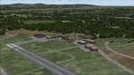
| Fly-N-D Landing Strip Airport (92NJ), NJ |
|
File Description:
Located 01 miles E of Kingwood Township, New Jersey on 121 acres of land, Fly-N-D Landing Strip Airport is a private turf field with a 2200' runway. There is no hard surface runway so setting your mesh as high as possible will lead to the best effects of landing on terrain. No transient storage or services are offered, and the airfield is not lit, so daytime VFR operations are recommended only.
Scenery constructed with use of satellite images/streetview/aerial photos - the author has not been there in person.
This scenery is meant to be used in conjunction with MegaScenery Earth New Jersey/Delaware 001. It is not required, but apron use is minimized to allow satellite scenery to show through as much as possible, and objects are placed based on the MSE textures - lack of it may make scenery look out of place.
| Filename: | FlyND_Landing_Strip_Airport_92NJ_NJ.zip |
| License: | Freeware |
| Added: | 23rd March 2011, 13:33:27 |
| Downloads: | 174 |
| Author: | Drew Sikora |
| Size: | 474.94 KB |
| Category: Flight Simulator X - Scenery | |
| RAF Deenethorpe |
|
File Description:
This is for FSX and you will need to have Ted Andrews's RAF Hangars Library and his other great RAF Buildings.
Deenethorpe was constructed in 1943 and was allocated to the United States Army Air Force Eighth Air Force. It was assigned USAAF designation Station 128.
With the opening of the airfield in October 1943, the 401st Bombardment Group (Heavy), arrived from Great Falls AAB, Montana, in November. The 401st was assigned to the 94th Combat Bombardment Wing of the 1st Bombardment Division. Its tail code was Triangle-S.
The 401st Bomb Group consisted of the following operational squadrons flying B-17s :
612th Bomb Squadron (SC)
613th Bomb Squadron (IN)
614th Bomb Squadron (IW)
615th Bomb Squadron (IY)
The 401st BG operated chiefly against strategic targets, bombing industries, submarine facilities, shipyards, missile sites, marshalling yards, and airfields; beginning in October 1944, concentrated on oil reserves.
| Filename: | RAF_Deenethorpe.zip |
| License: | Freeware |
| Added: | 16th January 2009, 11:08:33 |
| Downloads: | 699 |
| Author: | Scott Berge |
| Size: | 14.48 KB |
| Category: Flight Simulator 2004 - Scenery | |
| Emsdale CNA4 & Emsdale South fields in Ontario, Canada |
|
Images related to this file:
File Description:
Emsdale is on Hwy 11 about midway between North Bay and Lake Simcoe. A mile north of the town is Emsdale airfield CNA4, with two grass runways that are 12/30 2,500 feet long, and 17/35 2,000 feet long. There is only one hangar, no fuel, and in general there does not appear to be a lot of action. "Grass" may be a generous description of the runway surface, particularly for 12/30.
The second field is two miles southwest of Emsdale and privately owned. It has 2,700 feet or so of asphalt runway and a parallel grass runway (which is short at under 800 feet, plus a hangar at the north end!). There are six buildings, between hangars and office or club house and that about sums up all I know about it. If anyone knows more about this field please let me know.
| Filename: | Emsdale_CNA4__Emsdale_South_fields_in_Ontario_Cana.zip |
| License: | Freeware |
| Added: | 3rd February 2010, 15:35:35 |
| Downloads: | 390 |
| Author: | Roger Wensley |
| Size: | 1.91 MB |
| Category: Flight Simulator 2004 - Scenery | |
| Airstrips of Southern Germany |
|
Images related to this file:
File Description:
The next my Western Europe airstrips project, herewith about 170 small airfields, mostly in Baden-Wurttemberg and Bavaria, each enhanced with buildings, taxiways, parking spaces and aprons as appropriate, to further facilitate the generation of lightweight AI traffic in the area, without overloading the more major airfields.
Again, there's no photo-realism here, just a selection of basic 'generic' buildings, more or less accurately sized and placed to reflect the airfield layout as seen on on-line satellite imagery and aerial photography. These buildings have minimal effect on frame-rates, so are ideal for this kind of job. The airfields are aligned as well as possible with the roads etc. in UT Europe and the Genesis Europe mesh, but should mostly be fine in a default installation or other configuration.
Please read the rest of this "blurb" in the included text file. There may be some details of note or interest.
| Filename: | Airstrips_of_Southern_Germany.zip |
| License: | Freeware |
| Added: | 25th December 2024, 20:54:30 |
| Downloads: | 122 |
| Author: | Chris Eve |
| Size: | 2.84 MB |
| Category: Flight Simulator 2004 - Aircraft Repaints, Textures and Modifications | |
| Junkers Ju-52/3m EEES Greek Airlines circa 1938. |
|
Images related to this file:
File Description:

Junkers Ju-52/3m of EEES Greek Airlines circa 1938.
EEES (Elliniki Etairia Enaerion Sygkinonion-Greek Air Lines Company) was the first Greek airline founded in 1931. Three Ju-52 aircraft were delivered in 1938 to supplement the existing 4 Junkers G24he's fleet. EEES's pilots were trained by Deutsche Lufthansa and the Ju-52's were officially delivered at Berlin Tempelhof airport. Equipped with BMW 132A 660HP engines were registered SX-ACF (s/n 5984), SX-ACH (s/n 6004) and SX-ACI (s/n 6025). They were used at the Athens-Thessaloniki and Athens-Iraklio routes, operating from Athens Tatoi airfield (LGTT).
This is a Repaint Texture for Oliver Fischer's excellent Junkers Ju 52v.2. The base textures were kindly provided by O. Fischer. TEXTURES ONLY ---- In order to use these textures you must have the Junkers 52v.2 for Fs2004 (junkers_52_v2.zip -avsim Download #147734).
Re-upload
| Filename: | Junkers_Ju523m_EEES_Greek_Airlines_circa_1938.zip |
| License: | Freeware |
| Added: | 15th June 2010, 04:10:27 |
| Downloads: | 1,089 |
| Author: | Elias Korompilis |
| Size: | 6.29 MB |
| Category: Flight Simulator 2004 - Scenery | |
| KHAF - Half Moon Bay Airport - San Mateo County, California - USA |
|
Images related to this file:
File Description:
FS2004 Scenery - Half Moon Bay Airport (IATA: HAF, ICAO: KHAF, FAA LID: HAF) is a county-owned public use airport in San Mateo County, California, United States. It is located five nautical miles (9 km) northwest of the central business district of Half Moon Bay, California. The airport is on the Pacific Coast, south of San Francisco. The Half Moon Bay Airport is located approximately 20 miles south of San Francisco. It was constructed by the California State Highway Department for the U.S. Army in 1942 as an auxiliary airfield for Salinas Army Air Base. Following the end of World War II, San Mateo County acquired the airport from the Navy in 1947. The airport has served a variety of roles over the years and is currently an important business, transportation and emergency service asset to the community. For your flying pleasure by John B. Loney, Jr.
| Filename: | KHAF__Half_Moon_Bay_Airport__San_Mateo_County_Cali.zip |
| License: | Freeware, limited distribution |
| Added: | 5th August 2015, 18:58:17 |
| Downloads: | 318 |
| Author: | John B. Loney, Jr. |
| Size: | 11.87 MB |
© 2001-2026 AVSIM Online
All Rights Reserved
Privacy Policy |