
Where Flight Simulation Enthusiasts Gather from Around the World!
AVSIM Library - Search Results

| Category: Flight Simulator 2004 - Scenery | |
| Carp CYRP updated, near Ottawa in Ontario Canada |

|
Images related to this file:
File Description:
This version updates the post of 2006 with specifically modelled buildings for the east apron, plus a new AFCAD file. This is a stand-alone version and does not require you to have downloaded and installed the previous post. Carp airfield is fifteen miles west of Ottawa and two miles south of the town of Carp. There are two runways, 10/28 which is asphalt and almost 4,000 feet long and 100 feet wide, and 04/22 which is gravel and 2,000 feet long. The airfield has a fairly large polulation of general aviation residents and two years ago was expanding under new ownership, with a new terminal building and a large hangar opened and the "Touch'n Go" aviation warehouse that has opened more recently. The first version of Carp really included only the west apron, as that is where all (or almost all) the general aviation is located. I "represented" the east apron buildings without modelling any of them. This version corrects that, and the modeled east apron buildings are the HQ of Helicopter Transport Services Inc. and the adjacent Bell Helicopter service hangar, and the old First Air hangar and offices which are now under new ownership. The smaller hangars on the other side of the apron belong to chapter 245 of the Experimental Aircraft Association.
| Filename: | Carp_CYRP_updated_near_Ottawa_in_Ontario_Canada.zip |
| License: | Freeware, limited distribution |
| Added: | 16th February 2010, 03:18:39 |
| Downloads: | 562 |
| Author: | Roger Wensley |
| Size: | 6.03 MB |
| Category: Flight Simulator 2004 - Scenery | |
| Backcountry airfields for 19m terrain mesh in Idaho USA series 2 |
|
Images related to this file:
File Description:
These backcountry fields are for use with the FSGenesis 19m mesh of Idaho; they almost certainly do not work without it. The six airfields are a follow-on series to the previous four, ranging from Stanley that has a village and airfield buildings of one sort or another and even a length of asphalt runway, to Bruce Meadows that has two bathrooms. The full list from northwest to southeast is Bruce Meadows U63, Garden Valley U88, Warm Springs Creek 0U1, Stanley 2U7, Graham U45, and Smiley Creek U87. These airfields compensate for the loss of airfield flattens after the removal of AF917150 and AF917160, but there remain some now-unflattened airfields I have not included here, whether for reason of the impossibility of realistically creating it (as in the case of Flying B) or just a total lack of anything interesting about it. There may be some more follow-on fields that are new, to the north of the original four; these six are all to the south. The landclass files either change forested areas, as in Bruce Meadows, or add a village, as in Stanley. Although these are stand-alone, the presumption is that you have already installed the original four for use with the FS Genesis 19m terrain mesh, and there is a correction for Big Creek where I missed spotting a lack of flatten in one area.
| Filename: | Backcountry_airfields_for_19m_terrain_mesh_in_Idah.zip |
| License: | Freeware, limited distribution |
| Added: | 29th May 2017, 04:20:10 |
| Downloads: | 111 |
| Author: | Roger Wensley |
| Size: | 9.09 MB |
| Category: Flight Simulator 2004 - Scenery | |
| Chignik Lake A79 and Port Heiden PAPH - Alaska, USA |
|
Images related to this file:
File Description:
These are two villages in Alaska, in the peninsula that is the start of the Aleutians. Both are east of Perryville, Chignik Lake by 30 miles on the south side of the peninsula and Port Heiden by 75 miles on the north coast. Both are served by Grant Aviation government-subsidised regional flights from King Salmon. Chignik Lake has a population of around 70. There are two buildings on the airfield, but passengers still wait in their car for the plane to arrive as there is no terminal building as such. The runway is 3,300 feet of gravel aligned 08-26, as are so many in this area. Port Heiden is on the north shore of the peninsula, and the population is around 100. FS9 showed the town as being large enough to house 10,000; the new landclass here reduces this to the actual 40 or so houses, one and a half miles south of the airport. The roads are still the FS9 originals, which are approximately in the right place but are brightly lit at night as I was too lazy. The main occupation is fishing. There are buildings on the airfield (mostly old, except for a garage building) but passengers again wait in their cars for the plane to arrive. The two runways are both gravel, and are 05-23 of 6,200 feet, and 13-31 of 4,400 feet.
| Filename: | Chignik_Lake_A79_and_Port_Heiden_PAPH__Alaska_USA.zip |
| License: | Freeware, limited distribution |
| Added: | 30th March 2015, 20:28:47 |
| Downloads: | 291 |
| Author: | Roger Wensley |
| Size: | 5.1 MB |
| Category: Flight Simulator 2004 - Scenery | |
| Nikolski (IKO), Nelson Lagoon (Z73), & Perryville (AK5) - Alaska, USA |
|
Images related to this file:
File Description:
These are villages in Alaska, spread out east and west of Dutch Harbor in the Aleutians and the peninsula, served by Grant Aviation regional flights from Dutch Harbor, Cold Bay, or King Salmon.
Nikolski is 115 miles west of Dutch Harbor at the western end of Umnak Island, which is just west of Unalaska, the large island adjacent to Dutch Harbor. Nikolski is small, with a population of perhaps only 20 now, and the main claim to fame is the wrecked Reeve Aleutian DC3 at the end of the runway. The runway is 3,500 feet of gravel aligned 08-26. Nelson Lagoon is on the north shore of the peninsula, 55 miles north of Sand Point and on a long spit of land that curves around to make the lagoon. There is no access except by boat or plane for the population of around 50. The airfield is a mile east of the village with a gravel runway 08-26, 4,000 feet long. Perryville is on the south shore of the peninsula, 65 miles east of Sand Point. The population is around 115, and the airfield is southwest of the town with the 3,500 feet of gravel runway aligned 02-20 beside the shore. There is a hangar on the apron, but no terminal building.
| Filename: | Nikolski_IKO_Nelson_Lagoon_Z73__Perryville_AK5__Al.zip |
| License: | Freeware, limited distribution |
| Added: | 14th March 2015, 13:27:53 |
| Downloads: | 255 |
| Author: | Roger Wensley |
| Size: | 11.45 MB |
| Category: Flight Simulator 2004 - Scenery | |
| Albian CAL4, Firebag CFG6, Horizon CYNR, Mildred Lake CER4, and Muskeg Tower CFW4 in Alberta Canada |
|
Images related to this file:
File Description:
All of these airfields are in or close to the Athabasca Tar Sands in Alberta, modelled here along with the airfields. The tar sands workings extend along the Athabasca River for over 60 miles north of Fort McMurray in northern Alberta, and the huge cleared areas, surface mining, tailings ponds, and refineries along the Athabasca are right up there as Alberta's biggest VFR landmark. One look at a tailings pond (sea? ocean?) makes it clear that someone was worried about public reaction to the size. As well as the surface mining there are also large areas where there is underground extraction with a grid of dirt tracks between equipment installations. There are four airfields associated with the tar sands. Horizon CYNR is a public service airport operated by Canadian Natural Reources Ltd. Mildred Lake CER4 is owned and operated by Syncrude. Albian CAL4 is owned and operated by Shell Canada, and Firebag CFG6 is owned and operated by Suncor Energy. The fifth airfield is the nearby Muskeg Tower CFW4, which is there solely to support folks during their fire watch in the 120 feet tall tower. There is also a sixth airfield east of Horizon across the river and still visible, Bitumount; this is no longer in use. There is Ai included involving Canadian North, North Cariboo, Wasaya, HTS, First Air, Suncor, etc.
| Filename: | Albian_CAL4_Firebag_CFG6_Horizon_CYNR_Mildred_Lake.zip |
| License: | Freeware, limited distribution |
| Added: | 4th October 2013, 22:12:42 |
| Downloads: | 934 |
| Author: | Roger Wensley |
| Size: | 16.75 MB |
| Category: Prepar3D V1-4 - Aircraft Repaints, Textures and Modifications | |
| Boeing Stearman PT-13 (N1944S) |
|
Images related to this file:
File Description:
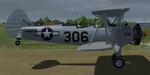
This folder contains a repaint for the Golden Age Simulations Boeing Stearman in the colors of PT-13D 42-177701 N1944S. Originally built in 1942 and used by the USAAF, this aircraft became N1944S in 1956 and flew in Colorado until 2006, when it was expoted to the Netherlands. It is still registered in the US as N1944S, but is now based on Texel airfield. In 2019 it received a new paintjob, to represent that way it looked when entering service with the USAAF in 1942, although the number 306 is based on the former sqaron of one of the owners. Repaint by Jan Kees Blom.
| Filename: | Boeing_Stearman_PT13_N1944S.zip |
| License: | Freeware |
| Added: | 23rd December 2019, 18:22:18 |
| Downloads: | 134 |
| Author: | Jan Kees Blom |
| Size: | 26.45 MB |
| Category: Flight Simulator X - Scenery | |
| RAF Horsham St Faith - Norfolk, England |
|
File Description:
RAF Horsham St Faith is a former Royal Air Force station near Norwich, Norfolk, England which was operational from 1939 to 1963. It was then developed as Norwich International Airport.
The airfield was first developed in 1939 and officially opened on 1 June 1940 as a bomber station. It had been built pre-war and had five C-type hangars, permanent brick and tiled buildings with central-heating and a high standard of domestic accommodation.
RAF Horsham St. Faith was a front-line RAF station for many years, and its squadrons participated in many post-war exercises. The station was deactivated on 1 August 1963.
| Filename: | RAF_Horsham_St_Faith__Norfolk_England.zip |
| License: | Freeware |
| Added: | 9th February 2016, 11:17:44 |
| Downloads: | 225 |
| Author: | Terry Boissel |
| Size: | 1.98 MB |
| Category: X-Plane - Scenery | |
| BR CE - SNAT Aracati Canoa Quebrada Airport v1.0.0 |
|
Images related to this file:
File Description:
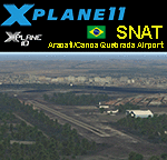
This is an X-Plane 11 and X-Plane 10 scenery package for Dragão do Mar Airport (ICAO: SNAT, no IATA code), which is the airport serving Aracati and the beach resort of Canoa Quebrada, Ceara, Brazil. It includes corrected aprons, ramps, gates, taxiways, lighting system, city buildings, ortho-photoscenery for the airfield area, and (XP11 only) airport ground services (like push back). This scenery was tested and is operational (as of March 21, 2017) in "X-Plane 11 Public Beta #15 64 bit", Windows 10 Home. It was also tested and is also operational (as of March 21, 2017) in "X-Plane 10.51 64 bit", Windows 10 Home.
| Filename: | BR_CE__SNAT_Aracati_Canoa_Quebrada_Airport_v100.zip |
| License: | Freeware |
| Added: | 22nd March 2017, 21:05:05 |
| Downloads: | 91 |
| Author: | Rui Mesquita |
| Size: | 13.36 MB |
| Category: X-Plane - Scenery | |
| BR AM SBEG - Eduardo Gomes Intl v1.0.0 |
|
Images related to this file:
File Description:
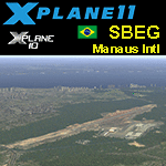
This is an X-Plane 11 and X-Plane 10 scenery package for Manaus International Airport - Eduardo Gomes (IATA: MAO, ICAO: SBEG) is the major international airport in Brazilian Amazon region, located in the city of Manaus, in Brazil. It includes corrected aprons, ramps, gates, taxiways, lighting system, city buildings, ortho-photoscenery for the airfield area, and (XP11 only) airport ground services (like push back). This scenery was tested and is operational (as of March 08, 2017) in "X-Plane 11 Public Beta #13 64 bit", Windows 10 Home. It was also tested and is also operational (as of March 08, 2017) in "X-Plane 10.51 64 bit", Windows 10 Home.
| Filename: | BR_AM_SBEG__Eduardo_Gomes_Intl_v100.zip |
| License: | Freeware |
| Added: | 9th March 2017, 04:49:39 |
| Downloads: | 191 |
| Author: | Rui Mesquita |
| Size: | 16.22 MB |
| Category: Flight Simulator 2004 - AI Aircraft | |
| Sikorsky S76 "Northwest Rotors" - fictitious paint for AI |
|
Images related to this file:
File Description:
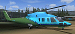
Sikorsky S76 "Northwest Rotors" - fictitious paint for AI. This paint is intended to replace the plain white S-76 AI aircraft in Robert Lacy's nicely crafted S23 Ione airfield scenery (ione_s23.zip) available at AVSIM. This paint requires the AI Sikorsky S-76C (elvis_sikorsky_s-76.zip - also available at Avsim). If you have the Ione scenery you may well already have Chris Jones' base model.The scheme is fictitious, made using a paintkit by fellow Aussie Mal Lloyd. Repaint by John Burford. Please unzip to a temporary folder and follow the simple installation instructions.
This is a replacement file for the file lost in the library hack.
| Filename: | Sikorsky_S76_Northwest_Rotors__fictitious_paint_fo.zip |
| License: | Freeware, limited distribution |
| Added: | 11th May 2010, 01:13:46 |
| Downloads: | 384 |
| Author: | John Burford |
| Size: | 249.26 KB |
© 2001-2026 AVSIM Online
All Rights Reserved
Privacy Policy |