
Where Flight Simulation Enthusiasts Gather from Around the World!
AVSIM Library - Search Results

| Category: Flight Simulator X - Aircraft Repaints, Textures and Modifications | |
| Automobile Association (1959 and 1960) de Havilland DH.89A Dragon Rapide (G-AHKV) |

|
Images related to this file:
File Description:
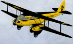
Aircraft repaint for Dave Garwood's de Havilland DH.89A Dragon Rapide Version 4 only. This is my first ever aircraft repaint. Compatibile with Microsoft Flight Simulator X and Lockheed Martin Prepar3D only.
Built in 1944 as NR693, G-AHKV (c/n 6792) served with British European Airways from 1946. By 1954 Sky Neon Aviation were flying the aircraft at night over London with underwing neon advertising signs. Registered to the Automobile Association in 1957, G-AHKV became the most famous of all their aircraft. Flown by former RAF Mosquito pilot Bill Lewis, she was used as a traffic spotter, monitoring congestion and incidents from the air. The prototype of the DH.89A Mk 6 conversion, G-AHKV had sophisticated electrical and navigation equipment on board. She was also an air ambulance, repatriating AA members who had suffered accidents or illness in Europe and dropping supplies to snowbound villages in Scotland. Sold by the AA in 1963, she was burnt at Birmingham Airport in 1969. Two variants of the livery are included.
| Filename: | Automobile_Association_1959_and_1960_de_Havilland_.zip |
| License: | Freeware, limited distribution |
| Added: | 25th November 2012, 17:54:00 |
| Downloads: | 315 |
| Author: | Adrian Petford |
| Size: | 4.1 MB |
| Category: Flight Simulator X - Scenery | |
| Essweiler Gliderfield, Germany Ver. 1.0 |
|
Images related to this file:
File Description:
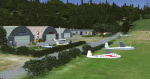
Essweiler is actually a classic glider field, but also engine aircrafts up to 2t are approved.
The field is situated in the region Rheinland-Pfalz/Germany at a hillside eastly of the village Essweiler, approximately 7,5 nautical miles north of the well known US-Airbase Ramstein.
The environment of the airfield is adapted by land classes. Surrounding villages and major roads are initially implemented.
As well the field is covered by a photo background, which includes four different images , each for one of the four seasons: spring, summer, autumn and winter. The buildings in this scenery should match quite good the originals. But also a lot of objects from three very popular freeware libraries are used.
If these libraries are not installed, many objects are not visible!
The following libraries are used:
1. FS-Piloten_Objektlibrary:
http://www.fs-piloten.de/thread.php?threadid=1063
2. FSX_FlightPortLib
http://www.flightport.de/libraries/flightport-library/
3: 3d People Library
http://library.avsim.net/download.php?DLID=192454
| Filename: | Essweiler_Gliderfield_Germany_Ver_10.zip |
| License: | Freeware |
| Added: | 29th November 2016, 19:15:50 |
| Downloads: | 605 |
| Author: | Wolfgang Allers |
| Size: | 168.18 MB |
| Category: Flight Simulator 2004 - Scenery | |
| Alaska North Slope 4: Lonely Air Force Station (AK71) |
|
Images related to this file:
File Description:
The town of Barrow is in the far north of Alaska, and these are coastal villages or radar installations to the west, south, and now east of Barrow. There will be further additions. Lonely Air Force Station AK71 is 80 miles east of Barrow and on the coast. It was, and at first sight appears still to be, a DEW station until you are close enough to see that the gravel apron is deteriorating. There is a gravel runway around 5,000 feet long, a large hangar, the DEW buildings, radar under the domes, the remains of huge line-of-sight communications reflectors, and oil tanks. Some DEW sites are not worth a visit; others are surprisingly intact and this is one of those. The AI takes place three days a week and is a C130, in which case the DEW site is still functioning or under mothball maintenance, a chartered Reeve Aleutian in which case the site is closed and they are documenting wildlife, and a Cessna with a group of the curious.
| Filename: | Alaska_North_Slope_4_Lonely_Air_Force_Station_AK71.zip |
| License: | Freeware, limited distribution |
| Added: | 20th June 2016, 08:02:18 |
| Downloads: | 307 |
| Author: | Roger Wensley |
| Size: | 2.32 MB |
| Category: Flight Simulator 2004 - Scenery | |
| Alaska South Slope 8; Shishmaref PASH |
|
Images related to this file:
File Description:
There are four main northwestern Alaska towns which are serviced by Alaska Airlines, and from which local flights spread out. The northernmost is Barrow. Southwest of Barrow is Kotzebue, then Nome, and the furthest south is Bethel (not yet made). This is the first in a series for flights from Nome, and it is Shishmaref, 125 miles north of Nome on the far side of the Seward Peninsula.
Shishmaref is a village on one of a string of islands off the northern shore of the Seward Peninsula, with a population of around 560. Like other similarly-sited villages (Kivalina, for instance) it is feeling the effects of coastal erosion and there are plans for a relocation, eventually. The airfield is just beside the village, with a runway of just under 5,000 feet of lit asphalt aligned 05-23, with PAPI on both ends. There are scheduled flights by Era (now renamed Ravn) and by Bering Air, both of them originating in Nome. The AI includes these flights along with Everts Air and GA.
| Filename: | Alaska_South_Slope_8_Shishmaref_PASH.zip |
| License: | Freeware, limited distribution |
| Added: | 20th October 2016, 04:37:02 |
| Downloads: | 213 |
| Author: | Roger Wensley |
| Size: | 2.32 MB |
| Category: Flight Simulator X - Scenery | |
| LOSM Mauterndorf, Austria Version1 for FSX and P3D_v3/v4 |
|
Images related to this file:
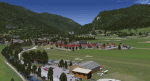
File Description: The Airfield Mauterndorf is the highest situated airfield in Austria: 3642 ft or 1110 meters above sealevel.
This Airfield is very common for glider flyers due to the usually good upwinds for flying in the alps. But also small engine aircrafts are approved. Link:
http://www.losm.at/index.php/losm.html The environment of the airfield is adapted by landclasses. Mauterndorf and the surrounding villages, valleys and major roads are included.
As well the field is covered by a photo background, wich includes four different images , each for one of the four seasons spring, summer, autum and winter. The buildings in this scenery are designed mainly new by myself, but also a lot of objects from two very popular freeware libraries.
If these libraries are not installed, many objects are not visible! The following libraries are used: 1. FS-Piloten_Objektlibrary:
http://www.fs-piloten.de/thread.php?threadid=10632 2.FSX_FlightPortLib:
http://www.flightport.de/libraries/flightport-library/ This senery works also with Austria Professional HD.
| Filename: | LOSM_Mauterndorf_Austria_Version1_for_FSX_and_P3D_.zip |
| License: | Freeware |
| Added: | 28th August 2017, 20:01:00 |
| Downloads: | 480 |
| Author: | Wolfgang Allers |
| Size: | 249.9 MB |
| Category: Flight Simulator 2004 - Scenery | |
| Kotzebue PAOT on the northwestern coast of Alaska |
|
Images related to this file:
File Description:
There are four main northwestern Alaska towns which have good airports and are serviced by Alaska Airlines. From these airports local flights connect to nearby villages, "nearby" in Alaska meaning up to 150 miles away. The northernmost is Barrow. Southwest of Barrow is Kotzebue, then Nome, and the furthest south is Bethel. The town of Kotzbue is north of the Bering Strait on the northwestern coast, 320 miles southwest of Barrow. The population is just over 3,000 people. The location was for a long time a base for trading in furs, with three rivers emptying into the sea and providing routes into the interior land and villages; a meeting place between hunters and traders from Russia and elsewhere. The Kotzebue airport is called the Ralph Wien Memorial and has two runways. The modern one is aligned 08-26 and is 5,880 feet of 150 feet wide asphalt built across a shallow lagoon, with an ILS on 08 and PAPI on both ends. The second and older runway is originally military and gravel, aligned 17-35 and 3,786 feet long and used (wind allowing) by the GA planes that park alongside the runway. The prevalent wind is from the west; when the wind is from the east it is generally relatively feeble and with a much lower cloud base, possibly to the ground, hence the need for an ILS. All AI aircraft in FS9 much prefer to use a runway that has an ILS and so will continue to use 08-26 even if the wind is from the south until it reaches 30+ knots, even if they are a Cessna 150 flying VFR. So for AI realism in FS9 a northern or southern wind needs to be a strong one so that the runway is actually used. However, as Alaska Airlines, Northern Air Cargo, and Everts Air also fly to Kotzebue and can only use the east-west runway (as less than 4,000 feet of asphalt would be seriously inconvenient for a Boing 737 or DC6) it is necessary to have the northern or southern wind UNDER 30 knots at the times when they are landing or taking off. Your choice. I suppose a permanent strong wind from the west would be the most realistic on a daily basis, deterring all planes from ever using 17-35. The AI will develop along with further scenery additions in the neighbourhood.
| Filename: | Kotzebue_PAOT_on_the_northwestern_coast_of_Alaska.zip |
| License: | Freeware, limited distribution |
| Added: | 2nd August 2016, 16:47:52 |
| Downloads: | 462 |
| Author: | Roger Wensley |
| Size: | 19.32 MB |
| Category: Flight Simulator 2004 - Scenery | |
| Alaska North Slope 10; Kivalina KVL in Alaska |
|
Images related to this file:
File Description:
The town of Barrow is in the far north of Alaska, and these are coastal villages or radar installations to the west, south, and east of Barrow on the North Slope. There will be further additions. Kivalina is a small village (population around 350) midway in the 150 mile gap between Point Hope to the north and Kotzebue to the south. The village is on a spit of land that is growing smaller and smaller with every year of erosion and the rise of sea level. The runway is 3,500 feet of gravel aligned 12-30 to the north of the village on the same spit. It was expected that 2025 would see the end of both village and runway, and possibly also the natural harbour that is the reason for the village's location. The modified width of the spit shown here is halved from the original FS9, and erosion has continued, enough that a sea defence wall has now been built. The AI has a daily flight by an ERA Alaska Cessna 208B, and some GA; read the note about the 208 to be downloaded and/or properly installed.
| Filename: | Alaska_North_Slope_10_Kivalina_KVL_in_Alaska.zip |
| License: | Freeware, limited distribution |
| Added: | 27th July 2016, 21:12:15 |
| Downloads: | 243 |
| Author: | Roger Wensley |
| Size: | 2.87 MB |
| Category: Flight Simulator 2004 - Scenery | |
| Alaska South Slope 2 - Noorvik ORV in AK US |
|
Images related to this file:
File Description:
The town of Kotzebue is in the far northwest of Alaska, and these are villages to the north and the east of Kotzebue on the South Slope of the Brooks Range of mountains. There will be further additions. Noorvik is a small village (population now around 670) on the bank of the Kobuk River, around 50 miles east of Kotzebue. The new airfield is 1 mile south of the village; there is a short runway immediately south of the town that is now closed but is not marked as such and appears to be usable; this will still be listed in FS9 when you are presented with a choice of runways but is not connected in any way to the new airfield so ignore it. The new ORV runway has 4,000 feet of lit gravel aligned 06-24. There are scheduled flights by Era (now renamed Ravn) and by Bering Air, both of them originating in Kotzebue and routing east to Noorvik, Kiana, Ambler, Shungnak, Kobuk, and then back again. The AI includes these flights (eventually) plus perhaps an Everts Air cargo flight and GA.
| Filename: | Alaska_South_Slope_2__Noorvik_ORV_in_AK_US.zip |
| License: | Freeware, limited distribution |
| Added: | 4th September 2016, 18:20:02 |
| Downloads: | 221 |
| Author: | Roger Wensley |
| Size: | 3.95 MB |
| Category: Flight Simulator 2004 - Scenery | |
| Alaska North Slope 5 - Nuiqsut PAQT |
|
Images related to this file:
File Description:
The town of Barrow is in the far north of Alaska, and these are coastal villages or radar installations to the west, south, and now east of Barrow. There will be further additions. Nuiqsut is a mainly Inuit community on the west side of the Colville River, around 20 miles south of the coast, and with a slowly declining population of around 420 or so. The airfield is just south of the town and has a gravel runway 5,000 feet long and aligned 04-22 in FS9. The airfield is the only year-round contact route to the rest of the world, though there are plans for a permanent road. The AI includes daily passenger flights early and late in the day, cargo deliveries, and some GA. It seems that the only photos I had of the airport were either of the old building or were not of Nuiqsut at all. The only pic I have seen (recently, which is why I now have doubts) of the new building is insufficient to model it, so I am sticking with the old or maybe incorrect version.
| Filename: | Alaska_North_Slope_5__Nuiqsut_PAQT.zip |
| License: | Freeware, limited distribution |
| Added: | 21st June 2016, 21:45:32 |
| Downloads: | 245 |
| Author: | Roger Wensley |
| Size: | 4.37 MB |
| Category: Flight Simulator 2004 - Scenery | |
| Alaska South Slope 6; Shungnak SHG |
|
Images related to this file:
File Description:
There are four main northwestern Alaska towns which are serviced by Alaska Airlines, and from which local flights spread out. The northernmost is Barrow. Southwest of Barrow is Kotzebue, then Nome, and the furthest south is Bethel (not yet made). This is a continuation of the series for the flights from Kotzebue, 150 miles to the east where Shungnak is on the bank of the Kobuk River. The next addition will be a few miles further east, Kobuk and a strip just to the north of Kobuk. Shungnak is a small village, like Ambler, with a population of around 260 beside the Kobuk River, the river being the reason for the existance of the villages as it served (and still does) as both a source of food and a transport route. The airfield is just beside the village, with a runway around 4,000 feet of lit gravel and aligned 09-27, with PAPI on both ends. There are scheduled flights by Era (now renamed Ravn) and by Bering Air, both of them originating in Kotzebue and routing east to Ambler, Shungnak, Kobuk, and then back again. The AI includes these flights along with Everts Air and GA.
| Filename: | Alaska_South_Slope_6_Shungnak_SHG.zip |
| License: | Freeware, limited distribution |
| Added: | 12th October 2016, 23:18:32 |
| Downloads: | 210 |
| Author: | Roger Wensley |
| Size: | 1.99 MB |


© 2001-2026 AVSIM Online
All Rights Reserved
Privacy Policy |