
Where Flight Simulation Enthusiasts Gather from Around the World!
AVSIM Library - Search Results

| Category: Flight Simulator 2004 - Gauges | |
| Simulated Aircraft Bubble Sextant Chart (addon) |

|
File Description:
This is an add-on to the "dc3_bbsx.zip" Simulated Aircraft Bubble Sextant Gauge. While the simulated sextant determines the elevation to the star, it requires drawing lines of position on a chart to ascertain the latitude and longitude of the fix. The Global Navigation Charts (GNC) at scale 5,000,000:1 are suitable but not generally available for this purpose. This gauge simulates small sections of the proper chart, and automatically places the LOP from the sextant on the chart in the proper orientation. It includes installation and operating instructions, and an example flight description. Install the "dc3_bbsx.zip" first, if it hasn't been installed already.
| Filename: | Simulated_Aircraft_Bubble_Sextant_Chart_addon.zip |
| License: | Freeware, limited distribution |
| Added: | 17th March 2008, 04:15:43 |
| Downloads: | 1,183 |
| Author: | Dave Bitzer, Mark Beaumont |
| Size: | 907.27 KB |
| Category: Flight Simulator 2004 - Scenery | |
| Barnstable/Boardman-Polando |
|
File Description:
FS2004 Scenery-Barnstable Muni-Boardman/Polando Field Airport (KHYA) in Massachusettes serves Hyannis and Barnstable County and is owned by Town Of Barnstable. The airport has more than one runway. The longest is a paved runway extending 5425 feet. The facility is at an elevation of 55 feet at a distance of about one mile from Hyannis. Created with EZ Scenery. EZ Scenery libraries required. New objects and textures by the author are included. Three AFCAD2 files are included for the default FS9 roads, USA Roads and Ultimate Terrain users. PLEASE READ THE README FILE!!! The UT AFCAD2 by Ray Lunning. Scenery by John B. Loney, Jr.
| Filename: | BarnstableBoardmanPolando.zip |
| License: | Freeware, limited distribution |
| Added: | 8th February 2007, 01:32:56 |
| Downloads: | 1,300 |
| Author: | John B. Loney, Jr. |
| Size: | 2.22 MB |
| Category: Flight Simulator X - Scenery | |
| SVMD - Merida, Venezuela |
|
Images related to this file:
File Description:
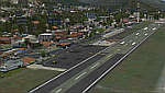
SVMD is an airport located 3 km southwest of downtown Merida, Venezuela, at an elevation of 1,526 m MSL. Its runway is 1,630 m long.
The runway has a gradient slope of +/- 4.05 %, for that reason, this airport is the most difficult and dangerous to land in Venezuela.
It is situated in a valley in the Andean mountains, surrounded by higher terrain in all
quadrants. Night operations are prohibited. Runway 07 is used for landings only and Rwy 25 is used only for take off.
Photo-terrain area improved with Autogen files.
Only compatible with versions to FSX or P3Dv1v2v3.x.
Also includes a friendly Auto-Install.
| Filename: | SVMD__Merida_Venezuela.zip |
| License: | Freeware |
| Added: | 9th December 2015, 09:13:34 |
| Downloads: | 1,040 |
| Author: | David Maldonado |
| Size: | 72.62 MB |
| Category: Flight Simulator 2004 - Scenery | |
| Homer Airport PAHO |
|
Images related to this file:
File Description:
FS2004 Scenery - Homer Airport (IATA: HOM, ICAO: PAHO, FAA LID: HOM) is a state-owned public-use airport located two nautical miles (4 km) east of the central business district of Homer, a town in the Kenai Peninsula Borough of the U.S. state of Alaska.
Homer Airport covers an area of 1,040 acres (421 ha) at an elevation of 84 feet (26 m) above mean sea level. It has one runway designated 3/21 with a 6,701 x 150 ft (2,042 x 46 m) asphalt pavement, and a facility for floatplanes on nearby Beluga Lake (5BL). This package consists of PAHO only. By John B. Loney, Jr.
| Filename: | Homer_Airport_PAHO.zip |
| License: | Freeware, limited distribution |
| Added: | 21st December 2010, 04:21:22 |
| Downloads: | 1,675 |
| Author: | John B. Loney, Jr. |
| Size: | 7.73 MB |
| Category: Flight Simulator X - Panels | |
| F111 Ground Mapping Radar |
|
File Description:
RADAR - Ground Mapping Radar - FSX Only.
FSX Alphasim F-111 Aardvark HUD.Navigation/Situation awareness cockpit.
Panel Update . Revision 2 ..26NOV2009. - ADDS RADAR.
GROUND MAPPING RADAR complete with AI aircraft and NAVAIDS.Provides
highly detailed elevation contours.14 Zooms from 1 to 300NM .Increasing
amount of Runway and text details close in.All data on/off selectable.
Ideal for navigation, air intercepts and extreme low valley flying.
Moveable and resizeable available in all 3 cockpits.
Adds to and enhances what is already the most comprehensive and capable
panel available for any military aircraft.
Must have Alphasim F-111 Aardvark PLUS fxpiggb1.zip(Free Panel upgrade)
By Karol Chlebowski.
| Filename: | F111_Ground_Mapping_Radar.zip |
| License: | Check within download |
| Added: | 28th November 2009, 20:12:45 |
| Downloads: | 510 |
| Author: | Karol Chlebowski |
| Size: | 2.66 MB |
| Category: Flight Simulator 2004 - Scenery | |
| Avon STOLPort (KWHR) |
|
File Description:
A recreation of the Avon STOLPort (ident KWHR) for MS Flight Simulator 2004, A Century of Flight. Avon was operated as an exclusive destination for Rocky Mountain Airways between (approximately) 1978 and sometime in the late 80's or early 90's. The 4,000' runway was short for the nearly 7,500' elevation, and surrounded by mountains, some towering over 6,000' above the airport elevation. To allow all weather operation, the airport eventually featured what was reported as the steepest ILS ever constructed, with a seven degree glideslope. RMA had exclusive use of the tiny STOLPort and operated it with 50-passenger De Haviland Dash 7 equipement.
Lacking the original chart, I surveyed in FS and plotted what is hopefully an accurate representation of the ILS approach, using my best understanding of TERPS - the US standard for instrument approaches. I also created an NOS-style IAP chart of this approach for the package. A text Takeoff Minimums & Procedure is also included.
AI ATC & traffic recognition of the approach will hopefully follow, but does not exist yet. In other words, you can fly this approach and see the localizer in the GPS, but AI ATC will not give you vectors to it. You'll need to follow the full procedure included on the chart.
Please see the full Readme.txt in "Flight Simulator 9\Addon Scenery\KWHR\Docs" in this zipfile for information on installation of the scenery, flying the approach, and more on the history of the Avon STOLPort.
| Filename: | Avon_STOLPort_KWHR.zip |
| License: | Freeware, limited distribution |
| Added: | 12th May 2008, 23:14:38 |
| Downloads: | 418 |
| Author: | Stephen Comer |
| Size: | 2.1 MB |
| Category: Flight Simulator 2002 - Scenery | |
| Canadian Rockies LOD 8 Mesh |
|
File Description:
As many of you know, NASA and the JPL have recently released 3 arc second (90 meter) elevation data for most of North America. The enclosed bgl file is intended to display the data more or less as it is, covering the Canadian Rocky Mountain National Parks.
Many people are probably curious about the new data, and this project has been an attempt to satisfy that curiosity in a spectacular area so far unpublished on the internet.
The data yields scenery in FS 2002 that far surpasses the default scenery. The area is also well visited by many people from around the world so I expect that this terrain will be recognizable to more than a few.
| Filename: | Canadian_Rockies_LOD_8_Mesh.zip |
| License: | Freeware |
| Added: | 9th April 2003, 02:36:31 |
| Downloads: | 1,966 |
| Author: | Gary Snow |
| Size: | 4.26 MB |
| Category: Flight Simulator 2004 - Scenery | |
| Craig Municipal Airport v1.5 |
|
File Description:
FS2004 Scenery-Craig Municipal Airport v1.5 (IATA: CRG, ICAO: KCRG) is a mid-sized facility for personal aircraft and small commuter planes located 8 mi (12.9 km) east of Jacksonville, Florida, United States. The airport has a control tower and handles 400-500 aircraft operations daily. Craig Municipal Airport serves Jacksonville and Duval County and is owned by Jacksonville Port Auth. The airport has more than one runway. The longest is a paved runway extending 4007 feet. The facility is at an elevation of 42 feet. THIS DOWNLOAD CORRECTS ALL REPORTED ERRORS FROM VERSION 1. Created with EZ Scenery whose libraries are required. The readme file is REQUIRED READING. By John B. Loney, Jr.
| Filename: | Craig_Municipal_Airport_v15.zip |
| License: | Freeware, limited distribution |
| Added: | 29th April 2007, 21:42:44 |
| Downloads: | 1,081 |
| Author: | John B. Loney, Jr. |
| Size: | 1.21 MB |
| Category: Flight Simulator X - Scenery | |
| JY43 Hill Top Airport NJ |
|
Images related to this file:
File Description:
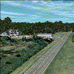
I was flying around the FSX world looking for a real world sloping airstrip just begging to be modeled with a touchdown tire squealing, smoking rubber - that kind of hardened surface sloping runway after I finally figured out how to persuade the FSX SDK to compile one. The Airfield Candidate shall have high density LiDAR elevation and high resolution Orthoimagery data available for public download. I was flying a Beechcraft Baron 58 over Wanaque Reservoir in Northeast NJ of all places when I happened upon a photo scenery runway on a sloping hill top without the usual FSX flattened airport plateau effect and FSX textured runway. They have missed this one ! Hello JY43. - Wally-Bob
| Filename: | JY43_Hill_Top_Airport_NJ.zip |
| License: | Freeware, limited distribution |
| Added: | 9th March 2011, 23:20:14 |
| Downloads: | 1,073 |
| Author: | Walter Roberts |
| Size: | 67.74 MB |
| Category: Flight Simulator 2004 - Scenery | |
| KMUV-Mojave Air and Space Port |
|
File Description:
This is scenery of a famous airport its like a graveyard of many airplanes also known as the Civilian Aerospace Test Center, is located in Mojave, California, at an elevation of 2,791 feet (851 m).The Mojave airport is also known as a storage location for commercial airliners. Numerous large Boeing, McDonnell Douglas, Lockheed, and Airbus aircraft owned by major airlines are stored at Mojave. Some aircraft reach the end of their useful lifetime and are scrapped at Mojave, while others are refurbished and returned to active service.You can see it miles away from the airport in flight simulator 2004.Its really realistic the airplanes are static airliners there not AI traffic, theres more than 50 planes..
| Filename: | KMUVMojave_Air_and_Space_Port.zip |
| License: | Freeware |
| Added: | 20th October 2008, 05:33:16 |
| Downloads: | 2,449 |
| Author: | Salvador Godoy |
| Size: | 3.33 MB |
© 2001-2026 AVSIM Online
All Rights Reserved
Privacy Policy |