
Where Flight Simulation Enthusiasts Gather from Around the World!
AVSIM Library - Search Results

| Category: Flight Simulator 2004 - Scenery | |
| LOD10 (38-m) Glacier Bay National Park, Alaska |

|
File Description:
This LOD10 (38-m) add-on mesh of Glacier Bay National Park and the adjacent Lynn Canal area between Juneau and Skagway (N58-60 W134-138) is an optional (!) upgrade of gl_bay_1.zip (by Holger Sandmann and Jim Keir). It adds more detail to the mountainous areas and allows to locally override other installed Alaska add-on meshes without having to deactivate them. The USGS NED seamless digital elevation data used for this mesh have a 2-arcsec (~60-m) resolution. Thus, the compilation as LOD10 (38-m) will reveal all terrain details contained in the source data. Please read the gl_bay_1.zip read-me file for further information about the special features of the Glacier Bay Project.
| Filename: | LOD10_38m_Glacier_Bay_National_Park_Alaska.zip |
| License: | Freeware, limited distribution |
| Added: | 16th February 2004, 03:40:57 |
| Downloads: | 8,593 |
| Author: | Holger Sandmann |
| Size: | 24.98 MB |
| Category: Flight Simulator 2004 - Scenery | |
| Mega Airport Memmingen (EDJA/FMM), Germany |
|
Images related to this file:
File Description:
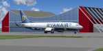
Memmingen Airport (EDJA) is located 100km West of Munich in Southern Germany. Several airlines operate out of the airport including Ryanair, Hapag-Lloyd Express, and Air Berlin. It's a small public airport. One of 4 airports in Bavaria with commercial air service and it has the highest elevation of all of Germany's commercial airports. Prior to 2008-09-25, it was known as Allgäu Airport/Memmingen. The airport not only serves Memmingen and the Allgäu area but also provides a low-cost alternative to Munich Airport.
This scenery is developed for FS2004 and updates the airport with new buildings and textures, along with the correct runway and taxiway dimensions and lighting.
| Filename: | Mega_Airport_Memmingen_EDJAFMM_Germany.zip |
| License: | Freeware, limited distribution |
| Added: | 7th July 2010, 23:19:27 |
| Downloads: | 6,250 |
| Author: | Ben Elsen |
| Size: | 9.49 MB |
| Category: Flight Simulator X - Scenery | |
| WA67 - Green Mountain Airport - Vancouver, Washington |
|
Images related to this file:
File Description: This is a revision of an airport originally included in my Oregon GA package.
This is a complete airport and can be installed alone, or you can add this
to the original and overwrite the older files. A member of the community
alerted me to elevation discrepancies; I had been using a 3rd party mesh when I
made this airport, which masked the discrepancy. This version will work
universally and also includes corrected approaches wherein I removed the default
ones and aligned these correctly to the current runway position; I added custom
runways lights to more accurately reflect reality and also made several relevant
detail changes.
| Filename: | WA67__Green_Mountain_Airport__Vancouver_Washington.zip |
| License: | Freeware, limited distribution |
| Added: | 6th January 2014, 16:28:32 |
| Downloads: | 637 |
| Author: | Rick Keller |
| Size: | 146.81 MB |
| Category: Flight Simulator X - Scenery | |
| Missing China Airports - ZUZY (ZYI) Zunyi Xinzhou Airport - ZUBD (BPX) Qamdo Bamda Airport |
|
Images related to this file:
File Description: Zunyi Xinzhou Airport (IATA: ZYI, ICAO: ZUZY) is a dual-use military and
civil airport serving the city of Zunyi in China's southwestern Guizhou
Province. It is located in the town of Xinzhou in Xinpu New Area. Tested with FSX Acceleration and UTX.
Qamdo Bamda Airport (IATA: BPX, ICAO: ZUBD), also known as Changdu Bangda
Airport, is an airport serving Qamdo (Changdu), Tibet, China. It is located in
the town of Bamda (Bangda). This airport features the worlds longest runway at
an elevation of 14219. Visitors are warned before landing to move slowly on
leaving the plane and that they may feel light headed or dizzy because of the
thin air.
| Filename: | Missing_China_Airports__ZUZY_ZYI_Zunyi_Xinzhou_Air.zip |
| License: | Freeware, limited distribution |
| Added: | 28th June 2014, 05:59:47 |
| Downloads: | 658 |
| Author: | Kevin Wynn |
| Size: | 171.14 KB |
| Category: Flight Simulator 2004 - Scenery | |
| Amundsen-Scott Station |
|
File Description:
The Amundsen-Scott South Pole Station is the American scientific research station on the high plateau of Antarctica. This station is located at the southernmost place on the Earth, the Geographic South Pole, at an elevation of 2,835 meters (9301 feet) above sea level.
Since the Amundsen-Scott Station is located at the South Pole, it is at the only place on the land surface of the Earth where the sun is continuously up for six months and then continuously down for six months. (The only other such place is at the North Pole, on the sea ice in the middle of the Arctic Ocean.) Thus, during each year, this station experiences one extremely long "day" and one extremely long "night". During the six-month "day", the angle of elevation of the Sun above the horizon varies continuously. The sun rises on the September equinox, reaches its maximum angle above the horizon on the summer solstice in the Southern Hemisphere, around 20 December, and sets onthe March equinox.
During the six-month "night", it gets extremely cold at the South Pole, with air temperatures sometimes dropping below -73 C (-100 F). This is also the time of the year when blizzards, sometimes with gale-force winds, strike the Amundsen-Scott Station. The continuous period of darkness and dry atmosphere make the station an excellent place from which to make astronomical observations.
This file has the apron and characteristics of the airport the coordenates are placed as far south FS allow it.
| Filename: | AmundsenScott_Station.zip |
| License: | Freeware |
| Added: | 17th October 2011, 22:02:39 |
| Downloads: | 668 |
| Author: | Anwar Gonzalez |
| Size: | 5.92 KB |
| Category: Flight Simulator X - Scenery | |
| Amundsen-Scott Station |
|
File Description:
The Amundsen-Scott South Pole Station is the American scientific research station on the high plateau of Antarctica. This station is located at the southernmost place on the Earth, the Geographic South Pole, at an elevation of 2,835 meters (9301 feet) above sea level.
Since the Amundsen-Scott Station is located at the South Pole, it is at the only place on the land surface of the Earth where the sun is continuously up for six months and then continuously down for six months. (The only other such place is at the North Pole, on the sea ice in the middle of the Arctic Ocean.) Thus, during each year, this station experiences one extremely long "day" and one extremely long "night". During the six-month "day", the angle of elevation of the Sun above the horizon varies continuously. The sun rises on the September equinox, reaches its maximum angle above the horizon on the summer solstice in the Southern Hemisphere, around 20 December, and sets on the March equinox.
During the six-month "night", it gets extremely cold at the South Pole, with air temperatures sometimes dropping below -73�°C (-100�°F). This is also the time of the year when blizzards, sometimes with gale-force winds, strike the Amundsen-Scott Station. The continuous period of darkness and dry atmosphere make the station an excellent place from which to make astronomical observations.
This file has the apron and characteristics of the airport the coordenates are placed as far south as FS allow it.
| Filename: | AmundsenScott_Station.zip |
| License: | Freeware |
| Added: | 17th October 2011, 22:01:33 |
| Downloads: | 1,294 |
| Author: | Anwar Gonzalez |
| Size: | 5.92 KB |
| Category: Flight Simulator X - Scenery | |
| LGLS - Lousoi Airfield **Fictional** |
|
Images related to this file:
File Description:
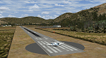
An imaginary airfield in north central Peloponnese Greece named after the elevated mountain plain where it would be situated. LGLS Lousoi airfield has a 1,000m runway at elevation of 3,186ft surrounded by mountains.
The aiport is equiped with NDB, ILS DME, PAPIs and night lighting for instrument approaches; approach chart included.
As bonus two imaginary helipads LGKK Kleitoria and LGPP Planitero are added in the nearby two villages.
All are infrastructure I wish they existed in the area since I drive there often for vacations in Planitero and always wondered how it would be if I could fly there. Planitero sits at the south footings of Chelmos mountain, the highest peak in the area. No AI traffic plans included.
| Filename: | LGLS__Lousoi_Airfield_Fictional.zip |
| License: | Freeware, limited distribution |
| Added: | 15th April 2015, 01:07:43 |
| Downloads: | 137 |
| Author: | Kyprianos Biris |
| Size: | 1.87 MB |
| Category: Flight Simulator X - Scenery | |
| Lake Kipawa - Quebec bush scenery |
|
File Description:
This scenery is fictitious and created for the pleasure of all. All the objects are already included in FSX and no other library was used. Seaplane base Kipawa is located on the North side of the lake, and this place is meant to be a site of free time for small boats. It can also be a refueling place for seaplanes. Lake Kipawa is situated at the far South West coast of Quebec, in the region of Abitibi-Temiscamingue. Must have before installing the Aerovirtuel bush flying sceneries:
1-Quebec Elevation 38m (LOD10) Gilles Gauthier sur http://avsim.com/ 5 files.
2-Quebec Scenery - Lakes and Rivers (1/5) http://avsim.com/ 5 files and one fix
3-Quebec Scenery - Addition of Roads http://avsim.com/
| Filename: | Lake_Kipawa__Quebec_bush_scenery.zip |
| License: | Freeware, limited distribution |
| Added: | 10th November 2007, 22:15:04 |
| Downloads: | 838 |
| Author: | Denis Dupuis |
| Size: | 1.01 MB |
| Category: Flight Simulator X - Scenery | |
| Lake Magpie - Quebec bush scenery |
|
File Description:
This scenery is fictitious and created for the pleasure of all. All the objects are already included in FSX and no other library was used. This scenery simulates the Headquarters of Aérovirtuel bush flying section for the region of Duplessis, Qc. The Lake Magpie is about 100Km North West of Havre St-Pierre. This place is hilly but perfect for a quick response for emergencies in the East part of Québec. This base has all services, oil gaz included.Must have before installing the Aerovirtuel bush flying sceneries:
1-Quebec Elevation 38m (LOD10) Gilles Gauthier sur http://avsim.com/ 5 files.
2-Quebec Scenery - Lakes and Rivers (1/5) http://avsim.com/ 5 files and one fix
3-Quebec Scenery - Addition of Roads http://avsim.com/
| Filename: | Lake_Magpie__Quebec_bush_scenery.zip |
| License: | Freeware, limited distribution |
| Added: | 10th November 2007, 22:15:41 |
| Downloads: | 846 |
| Author: | Denis Dupuis |
| Size: | 416.57 KB |
| Category: Flight Simulator 2004 - Scenery | |
| Santa Cruz - Bolivia, Viru Viru International SLVR / VVI |
|
Images related to this file:
File Description:

Thank you for downloading this scenery. This is a very basic rebuild of Viru Viru Int'l Airport. This airport serves as a major hub for Lloyd Aereo Biolivia and Aerosur. It is also a technical stop for long haul flights out of the more mountainous cities of Bolivia. Most aircraft cannot takeoff from airports like La Paz El Alto with a full load of fuel because of its 13,000ft elevation, and Viru Viru is close to sea level.
This scenery has a rebuilt terminal, jetways, baggage carts, and an AFCAD with added parking. There was very little information available other than sat photos, so it is not perfectly correct or photoreal, but it is a good basic representation.
| Filename: | Santa_Cruz__Bolivia_Viru_Viru_International_SLVR__.zip |
| License: | Freeware |
| Added: | 30th May 2010, 10:30:12 |
| Downloads: | 6,860 |
| Author: | William Morgan, FRFSTUDIO.NET |
| Size: | 1.34 MB |
© 2001-2026 AVSIM Online
All Rights Reserved
Privacy Policy |