
Where Flight Simulation Enthusiasts Gather from Around the World!
AVSIM Library - Search Results

| Category: Flight Simulator 2004 - AFCAD Files | |
| Fiji Airstrips |

|
File Description:
Afcads and exclude files for 11 airstrips in Fiji that Microsoft omitted from FS9. Made primarily with Ultimate Traffic users in mind, to give full traffic in the Fiji Islands (aircraft assigments permitting!).
The Afcads add runways, aprons and parking spots; the exclude files get rid of the autogen trees. Airstrips built using current data from Australian Defense Force En Route Supplements, so runway locations, dimensions, alignments and elevations are fairly accurate. But aprons and parking spots are entirely fictional! And no airport buildings included!
Tested only with default scenery plus fijifix.zip by Jim Keir (available at avsim) to correct elevation errors in default mesh at Moala.
Includes NFNB Levuka/Bureta, NFCI Cicia, NFKD Kandavu/Namalata, NFNO Koro Is, NFNK Lakeba, NFNH Laucala, NFFO Malololailai, NFMA Mana Is, NFMO Moala, NFNS Savusavu and NFVB Vanuabalavu.
| Filename: | Fiji_Airstrips.zip |
| License: | Freeware |
| Added: | 4th December 2004, 05:17:19 |
| Downloads: | 1,613 |
| Author: | Adrian Wright |
| Size: | 14.82 KB |
| Category: Flight Simulator 2004 - Scenery | |
| 71AK - Bluff Park Farm, plus others |
|
Images related to this file:
File Description:
Bluff Park Farm 71AK is on the northern side of Knik Arm, opposite Birchwood on the southern side. Wasilla Creek Airpark 05AK is just under 5 miles northeast of Wolf Lake. Memory Lake 5AK8 is 3 miles north of the town of Wasilla. The others, which are all in with the Wasilla Creek Airpark scenery, are scattered around and are mostly included in this list because of FS9 to UT altitude anomalies. Where there is a hangar or another building this as been added, but where there are no buildings I have just made the elevation adjustments so that there is no ridiculous "runway-in-a-hole" situation visible near one of the other airfields that I have made in the area. This post includes, in total, 71AK, 05AK, 5AK8, 3AK2, 05AK, 5AK5, 16AK, 34AK, 59AK, and AK65.
| Filename: | 71AK__Bluff_Park_Farm_plus_others.zip |
| License: | Freeware, limited distribution |
| Added: | 26th October 2014, 02:05:06 |
| Downloads: | 215 |
| Author: | Roger Wensley |
| Size: | 4.74 MB |
| Category: Flight Simulator X - Scenery | |
| SL02 - Alcantari International - Sucre-Yamparaez - Bolivia |
|
File Description:
The Alcantari International Airport (96% completed) (Spanish: Aeropuerto Internacional Alcantari) (IATA: unknown yet, ICAO: SL02, accordingly with some information over the WEB, pending of confirmation) is a new airport under construction in Yamparaez municipality, Chuquisaca, Bolivia, around 35 Km to the south of Sucre City. Alcantari International Airport is being built to address a number of limitations of the Sucre s current airport, Juana Azurduy de Padilla Airport (ICAO: SLSU).
The airport resides at an elevation of 10.210 ft (3.112 m) above mean sea level. The new airport will have one runway designated 18/36 (pending of confirmation) with an asphalt surface measuring 11,811 by 147.63 ft (3,600 m by 45 m)and it is expected to be operational by the first quarter of 2016.
Compatible with both FSX and P3D.
| Filename: | SL02__Alcantari_International__SucreYamparaez__Bol.zip |
| License: | Freeware |
| Added: | 3rd November 2015, 00:21:08 |
| Downloads: | 663 |
| Author: | Marcos A. Rivas Torrez |
| Size: | 9.31 MB |
| Category: Flight Simulator X - Scenery | |
| CYBA - Banff Airfield |
|
File Description:
Welcome to Beautiful Banff - CYBA :)
Banff is the largest town in Banff National Park, in Alberta's Rockies, Canada. It is also the first incorporated municipality located within a national park in Canada. At 1,463 m (4,800 ft), it is the town with the highest elevation in Canada.
It is surrounded by mountains, notably Mount Rundle, Sulphur Mountain, Mount Norquay, and Cascade Mountain and situated above Bow Falls near the junction of the Bow and Spray Rivers. Banff is located 126 km (78 mi) west of Calgary and 58 km (36 mi) east of Lake Louise, on the Trans-Canada Highway. The Town is a member of the Calgary Regional Partnership.
I have put a little " winter life" in this awesome airfield. 2 fuel parking, Helipad and more....
Hope you'll enjoy the scenery on final landing! ;)
No A.I set up!
| Filename: | CYBA__Banff_Airfield.zip |
| License: | Freeware |
| Added: | 11th March 2009, 01:08:10 |
| Downloads: | 1,845 |
| Author: | Daniel Louvet |
| Size: | 384.91 KB |
| Category: Civil Flight Simulators - Looking Glass Flight Unlimited 3 | |
| Seattle Expansion Toolkit |
|
File Description:
Conversion of the Seattle Region from .cpd to .bin for FU3
This experimental toolkit is for region builders, its not a new full game !
If you want expand the region with new material to the north and the east then
conversion to .bin is a must.
Do not convert if you don't plan to expand or modify texture of the tiles.
Then the only results are a larger game folder :-(
The quality of the original tiles will not change !
The Seattle region is converted from 10x10 tiles area into a 16x16 tiles area but just 2 new tiles are made north of Coupeville Nolf as sample, so 154 tiles are then still missing and replaced by the blank tile (new full water tile). As elevation the new NASA-SRTM-V2 model is used. Backup your Seattle region before starting the experiment.
| Filename: | Seattle_Expansion_Toolkit.zip |
| License: | Freeware, limited distribution |
| Added: | 17th February 2007, 22:24:07 |
| Downloads: | 121 |
| Author: | Andre Meystre |
| Size: | 41.8 MB |
| Category: Flight Simulator 2004 - Scenery | |
| Modified SRTM relief 76 m for Slovakia |
|
File Description:
This Slovak terrain mesh 76 m (LOD9) is made from the 3arc-sec SRTM. The voids in the source data were filled by the interpolation. Both the primary processing of the 3arc-sec data and the rendering of the terrain in the FS cause flattening and simplifying of the real shape of the terrain. This phenomenon was partially compensated by the sharpening of the source data.
Made by the programs Surfer (Golden Software) and MS Terrain SDK 2000 and 2002. The relief covers the area N49.9219 E016.1719 to N47.4609 E022.9687 in the boundaries of the LOD9 quadrants. This scenery contains only the elevation data. The other elements of the basic terrain as the landclass, locally used airborne photos, vector roads, rivers and lakes are available in different sceneries by other authors and they are continuously developed.
| Filename: | Modified_SRTM_relief_76_m_for_Slovakia.zip |
| License: | Freeware, limited distribution |
| Added: | 28th May 2010, 19:40:13 |
| Downloads: | 4,604 |
| Author: | Vladimir Stoje |
| Size: | 19.36 MB |
| Category: Flight Simulator 2004 - Scenery | |
| "Caiolo" Sondrio Airport, Valtellina, North Italy |
|
Images related to this file:
File Description:
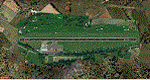
In this airport reside AvioValtellina and VolaValtellina, as well as the operational base of the Health Service 118 and Mountain Rescue. It also base of the Aeroclub Sondrio with its Flight School VDS. Site at the beginning of the Valtellina, in Caiolo municipality (N46 09.0 E09 48.0), has an asphalt runway from 1050x23 mts, ground communication frequency 129.50; ICAO code: LILO. It is also enclosed the base of INAER Aviation, located in Colico-Piantedo (N46 08.18 E09 24.19 - code LIEI), that operates in Medical Emergency, rescue operations in the mountains and off-shore. Scenery realized on the real cooordinates of the airport (except for elevation) including the scenery of the heliport INAER Colico. Requires the use of the libraries' dva51 "and the system of vegetations "TreePlanter".
Enjoy!
A presentation video is available here.
| Filename: | Caiolo_Sondrio_Airport_Valtellina_North_Italy.zip |
| License: | Freeware |
| Added: | 25th October 2014, 11:52:25 |
| Downloads: | 856 |
| Author: | Aldo Della Vedova |
| Size: | 29.5 MB |
| Category: Flight Simulator 2004 - Scenery Design | |
| TCalc2004 |
|
File Description:
UpDated!! TCalc2004 is made for use with FDSConnection.dll ( included ) and FS2004. This is a version that includes true heading readings and ground elevation. This version also has the LOD8 Zone for VTP2 for the VTPDataArea. It also has info regarding the name of the likely default BGLs. It gives the name of the CUSTOM ( photoreal ) texture and it's neighbors. It gives the x, y locaton of the QMID7... for quick jumping in TMFViewer. It requires FDSConnection.dll be copied to the FS9 Modules folder. FDSConnection.dll is included in the package courtesy of Michael De Feyter and www.flightdecksoftware.com, and is freeware. FDSConnection.pdf is also included. LandCalc.exe, TDFCalc2.exe, and TMFViewerCalc.exe are also included. A VTP2CUSTOM example of placing CUSTOM textures is also included. Updated with a new FDSConnection version, and an "on top" version that always stays on top. Small bug corrections, as well.
| Filename: | TCalc2004.zip |
| License: | Freeware |
| Added: | 24th November 2003, 04:51:39 |
| Downloads: | 2,928 |
| Author: | Richard Ludowise |
| Size: | 1.77 MB |
| Category: Flight Simulator X - Utilities | |
| ILS Approach Checklist |
|
Images related to this file:
File Description:
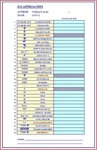
This is an easy to read Excel spreadsheet that is an ILS Approach Checklist that starts when you receive landing clearance by ATC that you are approx. 70 miles out from your assigned ILS Runway. By utilizing this checklist you will ensure not to forget any of the steps necessary for a successful ILS Landing. The following fields are provided:
(Landing Instructions) (Clearance) (Landing Info)
(Descent Rate) (ILS Frequency) (Course)
(Airport Elevation) (Radio Stack) (Nav 1 Frequency)
(Click Nav 1) (Hear Morse Code) (Enter Course)
(Enter Speed) (10 nm Cleared to Land) (Press Approach Button)
(Arm Auto Brake) (Arm Spoilers) (Gear Down)
(Set Flaps) (10-15-20-25-30-35-40 Flaps) (500' Disengage Auto-Pilot)
(Flare-Nose Up) (Reverse Thrusters) (Apply Brakes)
(Gate Assignment) (Gate Arrival) (Unload Passengers)
(Shutdown).
| Filename: | ILS_Approach_Checklist.zip |
| License: | Freeware |
| Added: | 5th February 2012, 14:15:06 |
| Downloads: | 1,569 |
| Author: | William R Ayers |
| Size: | 18.98 KB |
| Category: Flight Simulator 2004 - Scenery | |
| New Terrain Mesh of the Province of Quebec in LOD09 (1/4) |
|
File Description:
The files in this package contain terrain mesh files of the province of Quebec (N45 to N53) to be used with my Quebec enhanced sceneries for FS2004 (Scenes_du_Quebec_2k4.zip). The public data sources are the Shuttle Radar Topography Mission (SRTM-3, 90m) and the Canadian Digital Elevation Data (CDED - 0.75s/arc - 23m). (QC09_2k4a.zip to QC09_2k4d.zip - 4 parts)
***********************
Les fichiers de ces archives contiennent les donnees d'elevation de terrain (mesh files - lod09), pour FS2004, du territoire de la province de Quebec sous le 53ieme degre de latitude nord. Ils ont ete crees pour etre utilises avec mes nouvelles scenes du Quebec contenues dans Scenes_du_Quebec_2k4.zip. Les donnees sources sont du domaine public et proviennent de la Shuttle Radar Topography Mission (SRTM-3, 90m) et des donnees numerique d'elevation du Canada (DNEC - 0.75s/arc -23 m). (QC09_2k4a.zip to QC09_2k4d.zip - 4 parties)
| Filename: | New_Terrain_Mesh_of_the_Province_of_Quebec_in_LOD09_14.zip |
| License: | Freeware, limited distribution |
| Added: | 27th January 2010, 18:10:18 |
| Downloads: | 8,915 |
| Author: | Gilles Gauthier |
| Size: | 23.76 MB |
© 2001-2026 AVSIM Online
All Rights Reserved
Privacy Policy |