
Where Flight Simulation Enthusiasts Gather from Around the World!
AVSIM Library - Search Results

| Category: Miscellaneous Files - General Utilities | |
| mLaunch - Application launcher and monitoring |

|
File Description:
mLaunch starts a predefined list of programs and monitors one or more of them. If an application that was flagged closes, then all the other applications in the list closes.
The application is freeware and does not need any setup. It's only one executable file.
Requirements: .NET Framework 3.5
Features:
- User defined application list
- Save the list as a text file
- Manually starting and stopping of the required applications
- Automatic starting of the applications using command line parameter
- Define one or more applications as a KILL- trigger. mLaunch checks periodically if the defined apps are still running. If not, all the rest applications are closed too.
- Visible in system tray when minimized
- User defined check period (Default: 15 seconds)
My typical use:
-The list contains all the applications that i want for FS (ActiveSKy, Jeppesen,FS Realtime, Servinfo...) and of course it contains the actual fs9.exe in the end of the list. Only fs9.exe has the close flag enabled (Close Flag = 1) . When FS closes then all the programs are closed too.
| Filename: | mLaunch__Application_launcher_and_monitoring.zip |
| License: | Freeware |
| Added: | 1st September 2010, 21:33:49 |
| Downloads: | 143 |
| Author: | Elias Stassinos |
| Size: | 129.69 KB |
| Category: Flight Simulator 2004 - Scenery | |
| CYYH - Taloyoak - Nunavut, Canada |
|
Images related to this file:
File Description:
Taloyoak is on the coast of northern mainland Canada, on the west of the Boothia Peninsula, where it is at it's narrowest. Gjoa Haven is 80 miles southwest, and Hall Beach is 300 miles to the east. Taloyoak was established around a Hudson Bay trading post that was relocated from Fort Ross in 1948 because of poor ice conditions. There is now a clinic, school, church, recreation centre, two markets, two small hotels, and housing for the population of around 900. The airfield is to the west of the village on higher ground at 92 feet asl, and the 4,020 feet of 100 feet wide gravel runway is aligned 151T/331T where T stands for "true" as opposed to magnetic in the Northern Domestic Airspace. Only JETA-1 is available, unless there is some 100LL in drums. There are flights by First Air and Canadian North and the AI includes a daily flight of each, plus an afternoon cargo visit by a Buffalo C46; the closest large city is Yellowknife, 750 miles southwest.
| Filename: | CYYH__Taloyoak__Nunavut_Canada.zip |
| License: | Freeware, limited distribution |
| Added: | 18th November 2012, 09:23:20 |
| Downloads: | 377 |
| Author: | Roger Wensley |
| Size: | 3 MB |
| Category: Flight Simulator X - Missions | |
| Challenging Approach: Innsbruck, Austria, LOWI |
|
File Description:
This is the first in a series of missions on challenging approaches and landings. The mission begins with you are approaching SBG VOR, enroute to Innsbruck, Austria, LOWI. As you approach Rattenberg NDB, ATC commands 200 KIAS and 9500' to intercept RTT (Goal 1). You are also advised to enter a holding pattern at RTT, your fix, to allow time for snow removal from the runway. The pattern is standard right-hand turns with 1.5 minute legs and 200 knots at 9500'. The inbound track is 226°, while outbound is 46°. Winds are high, so you will have to compensate to stay aligned in the pattern and certify (Goal 2). Next up is to achieve a stabilized approach on the steep glide slope to runway 25 as Goal 2. The final goal is a safe full stop landing on runway 26 at elevation 1894' The descent is near 4° gradient and the runway VOR (111.1) is offset to the right, thus the “challengeâ€. Complete all three goals and you certify to fly to LOWI and receive a Reward.
| Filename: | Challenging_Approach_Innsbruck_Austria_LOWI.zip |
| License: | Check within download |
| Added: | 6th May 2023, 13:41:36 |
| Downloads: | 109 |
| Author: | Jake Rogers |
| Size: | 10.73 MB |
| Category: Flight Simulator X - AFCAD Files | |
| PAOT - Wien Meml - Kotzebue, Alaska |
|
Images related to this file:
File Description:
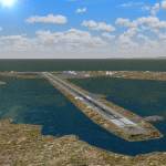
This AFCAD of the airport Wien Meml - Kotzebue (PAOT), Alaska, fixes some issues for Scenery Solution's UTX Alaska users who want to use mesh and texture resolutions better than 38 m and 1 m, respectively. Unfortunately this discloses some additional problems with lagoons surrounding runway 09/27. Some of the ponds had been elevated over apron level, the fence Microsoft had drawn around the airport ran through (elevated) water and so on. Runway 27 has no direct connection to the mainland like it is realized by UTX and furthermore a lot of water polygons (including the lagoons) had 'forgotten' shore line vectors. Included corrections are: fixed main waterpolygons around the airport (according to Google Maps), fixed airport layout, including aprons, GA parking, additional airport buildings (default FSX objects), fixed Runway designators (now 09/27 resp. 18/36 instead of 08/26 and 17/37, Nov. 2013), added shoreline vectors (compatible to UTX textures) and some more.
Again, THIS AFCAD IS INTENDED FOR USERS OF UTX ALASKA ONLY and will likely look horrible in other environments as it partially amends missing features only.
| Filename: | PAOT__Wien_Meml__Kotzebue_Alaska.zip |
| License: | Freeware, limited distribution |
| Added: | 3rd February 2014, 14:30:10 |
| Downloads: | 410 |
| Author: | Axel Birsul |
| Size: | 1.09 MB |
| Category: Flight Simulator 2004 - Aircraft Repaints, Textures and Modifications | |
| VLM Airlines Fokker 50 (OO-VLS) |
|
Images related to this file:
File Description:
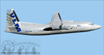
This is an Fokker 50 in VLM Airlines colors, Registration: OO-VLS, Repaint by: Mathieu Vos (APSS), Model by: Dreamwings.
VLM Airlines was until Air France-KLM announced on December 24, 2007 to take over, an autonomous, independent airline. On May 28, 2009 it was announced that Air France-KLM her daughter VLM Airlines will integrate. CityJet in Since 2010 VLM wast no longer disseminated to the public. as a brand from the beginning of 2010, all aircraft repainted in VLM colors and they will bear the name CityJet. The last VLM flight was on Friday, March 26, 2010 with the first Fokker 50 which they possessed, the OO-VLM. As of May 1, 2014, VLM Airlines is owned by Intro Aviation GmbH and is scheduled carriers converted to ACMI and charter operator. 8 aircraft flying in the colors of CityJet (currently the largest customer) and two sets in FlyVLM colors. The other two are still unknown though there are rumors that one unit will fly in Vision air colors, VLM Airlines has been used worldwide.
Also compatible for FSX.
| Filename: | VLM_Airlines_Fokker_50_OOVLS.zip |
| License: | Freeware |
| Added: | 7th July 2014, 08:58:34 |
| Downloads: | 551 |
| Author: | Mathieu Vos (APSS) |
| Size: | 2.73 MB |
| Category: Flight Simulator X - AFCAD Files | |
| Coombs Airport (7NJ7), NJ |
|
File Description:
Located 04 miles NE of Elmer, New Jersey, Coombs Airport is a private turf field 2000' in length wilth clear 20:1 approach and departure at each end of the runway. You'll find some surrounding buildings but they are all located several hundred yards from the runway. This is a good strip to keep in mind for emergencies if you're in the area. You will be landing on terrain so having your mesh complexity set as high as possible is recommended. This airport is not lit at night, daytime VFR operations only are suggested. There are no transient services offered.
Scenery constructed with use of satellite images/streetview/aerial photos - the author has not been there in person.
This scenery is meant to be used in conjunction with MegaScenery Earth New Jersey/Delaware 004. It is not required, but apron use is minimized to allow satellite scenery to show through as much as possible, and objects are placed based on the MSE textures - lack of it may make scenery look out of place.
| Filename: | Coombs_Airport_7NJ7_NJ.zip |
| License: | Freeware |
| Added: | 16th February 2011, 00:03:55 |
| Downloads: | 191 |
| Author: | Drew Sikora |
| Size: | 756.22 KB |
| Category: Flight Simulator X - AFCAD Files | |
| SAWH-Ushuaia International Airport-Argentina |
|
File Description:
Ushuaia International Airport (Spanish: Aeropuerto Internacional de Ushuaia) (IATA: USH, ICAO: SAWH) is located 4 km (2.5 mi) south[1] of the center of Ushuaia, a city on the island of Tierra del Fuego in the Tierra del Fuego
Province of Argentina.Ushuaia International Airport is fit to receive airplanes as large as the Boeing 747. Tower Air used to operate such types into the airport, and AeroliÂneas Argentinas operated 747-400s into the airport
during events of high passenger numbers (such as entire cruise-ship passenger payloads) until retiring this aircraft type in February, 2012. Two chartered Air France Concordes also visited in the past: F-BTSD arriving from
Buenos Aires and continuing to Santiago, Chile, in early 1999; the second arriving from Easter Island, Chile and continuing to Buenos Aires prior to the cessation of most Concorde charter flights on July 25, 2000. Condor and
LTU also offered charter flights from Germany and First Choice Airways from the United Kingdom. It also offers charter flights to Maputo, Mozambique.
This work is dedicate to Tiziano Fiori who lives in Trelew.
| Filename: | SAWHUshuaia_International_AirportArgentina.zip |
| License: | Freeware |
| Added: | 27th September 2012, 23:55:23 |
| Downloads: | 793 |
| Author: | Anwar Gonzalez |
| Size: | 58.72 KB |
| Category: Flight Simulator X - AFCAD Files | |
| TKPK - Robert L. Bradshaw International Airport / Saint Kitts and Nevis |
|
Images related to this file:
File Description:
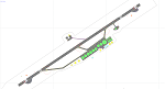
This airport update was made with the latest version of ADE (Airport Design Editor) and made for FSX as a replacement for the stock (default) airport. I've made several changes to the airport which are listed below. All these enchancements are as close to the real airport as I can get with stock library objects. I've used satellite images, terminal photos and maps throughout the whole process so building locations are as accurate as possible. Happy landings in sunny Saint Kitts and Nevis!
Features:
*Expanded parking apron
*Main terminal building with parking area for commercial traffic (Gates 1-9)
*St. Kitts airport sign
*Seperate parking area for GA traffic
*Parking stand for cargo (Gate 9)
*Misc airport buildings added
*Airport vehicles and objects throughout the airport
*Fuel tanks and station
*Airport fire station
*Windsocks added
*Birds flying near runway (beware)
*Palm trees/vegitation added near terminal
*Taxiway signs
*Taxiways Bravo and Charlie properly assigned
*New taxiway Alpha added
(For more information about Endeavourai please visit our site at endeavourai.com)
| Filename: | TKPK__Robert_L_Bradshaw_International_Airport__Sai.zip |
| License: | Freeware |
| Added: | 1st September 2012, 21:23:20 |
| Downloads: | 819 |
| Author: | Jaison Diaz / Endeavour ai |
| Size: | 87.92 KB |
| Category: Flight Simulator 2004 - Aircraft Repaints, Textures and Modifications | |
| Paradise Airlines Lockheed L-049 Constellation |
|
Images related to this file:
File Description:
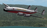
Textures for the Lockheed L-049 Constellation by the team Roland Berger, Volker Boehme, Manfred Jahn, Luis Pallas, Bill Tyne and Stefan Werner. Repaint by Manfred Meyer.
The company Nevada Airmotive bought TWA's L-049 fleet in 1962 for lease and/or resell them. But only fife of the 25 Constellations found new operators .
One of these aircrafts was c/n 2025, built 1945 and used by Lockheed as factory demonstrator until delivered to TWA as NC86504 "Star of France" in 1946. Sold to Nevada Airmotive in 1962 and leased to Futura Airlines and some month later to Paradise Airlines Inc. Oakland, CA. Paradise used the plane together with two further Constellations for flights from Oakland, Salinas, San Jose and other points in California to Lake Tahoe, bringing peoples to Horrah's gambling club there. Sadly N86504 crashed 1. march 1964 nine miles northwest of Lake Tahoe into the mountains with the lost of all 85 on board. Paradise AL then was forced to close down by FAA for failing to conduct a safe operation.
| Filename: | Paradise_Airlines_Lockheed_L049_Constellation.zip |
| License: | Freeware |
| Added: | 11th July 2015, 11:26:45 |
| Downloads: | 124 |
| Author: | Manfred Meyer |
| Size: | 4.14 MB |
| Category: X-Plane - Scenery | |
| 2017 TMA Fortaleza XP11 Package SBFZ SJCM SJDS SNFF v1.1.0 |
|
Images related to this file:
File Description:

Version 1.1.0 (2017) - This is an X-Plane 11 scenery package for Fortaleza, Ceara, Brazil. It includes four airfields located in the metropolitan area of Fortaleza. 1. SBFZ/FOR - Pinto Martins International Airport v1.1.0. 2. SJCM - Catuleve Aeronautical and Sports Airfield v1.0.0. 3. SJDS - Fabrica Fortaleza Private Airport v1.0.0. 4. SNFF - Feijo Flight School and Private Airfield v1.0.0. It includes corrected aprons, ramps, taxiways and lighting system for SBFZ/FOR airport. v1.1.0 includes also the construction work of the terminal expansion, and XP11 ground services (like pushback) enabled. SBFZ/FOR scenery was tested and is operational (as of February 04, 2017) in "X-Plane 11 Public Beta #8 64 bit", Windows 10 Home. It was also tested but is NOT operational (as of January 27, 2017) in "X-Plane 10.51 64 bit", Windows 10 Home. This happens for two reasons: (a) XP11 native ground traffic/services enabled for SBFZ/FOR ground, a feature compatible only with XP11, and (b) the use of some internal Laminar Research made libraries for XP11 only, not present in XP10 libraries.
| Filename: | 2017_TMA_Fortaleza_XP11_Package_SBFZ_SJCM_SJDS_SNF.zip |
| License: | Freeware |
| Added: | 4th February 2017, 20:00:41 |
| Downloads: | 251 |
| Author: | Rui Mesquita |
| Size: | 18.35 MB |


© 2001-2026 AVSIM Online
All Rights Reserved
Privacy Policy |