
Where Flight Simulation Enthusiasts Gather from Around the World!
AVSIM Library - Search Results

| Category: Flight Simulator 2004 - Aircraft Repaints, Textures and Modifications | |
| Aer Lingus "St Dervilla" Airbus A321 **Thumbnail fix** |

|
File Description:
fix for my Aer Lingus A321 pack for SMS/Overland's Airbus A321 (which sported the wrong 'Air Canada' thumbnail instead of Aer Lingus), link = https://library.avsim.net/download.php?DLID=200350. Sorry for the fault !
| Filename: | Aer_Lingus_St_Dervilla_Airbus_A321_Thumbnail_fix.zip |
| License: | Freeware |
| Added: | 7th July 2017, 17:06:00 |
| Downloads: | 106 |
| Author: | Wan Tjhen |
| Size: | 68.86 KB |
| Category: Flight Simulator X - Aircraft Repaints, Textures and Modifications | |
| Klinik Gut St. Moritz Cessna C182T (HB-CMZ) |
|
Images related to this file:
File Description:
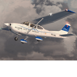
Real livery of HB-CMZ, based at Samedan. The plane belongs to the "Swiss Leading Hospitals" group. The original plane is flown without front Wheel pants and a 2 blade prop. Textures only. You need to own a legal copy of the A2A Cessna C182T.
| Filename: | Klinik_Gut_St_Moritz_Cessna_C182T_HBCMZ.zip |
| License: | Freeware, limited distribution |
| Added: | 13th December 2014, 21:10:51 |
| Downloads: | 307 |
| Author: | Eberhard Haberkorn / A2A |
| Size: | 15.19 MB |
| Category: Prepar3D V1-4 - Scenery | |
| Sanctuary St. Anna Vinadio Cuneo Italy N44.13.53 E7.06.19 |
|
Images related to this file:
File Description:
Sanctuary St. Anna Vinadio Cuneo Italy N44.13.53 E7.06.19. The Sanctuary is the second highest sanctuary in Europe, being located at 2,035 m s.l.m. of the altitude in fact The world's first highest sanctuary is at the top of Mount Rocciamelone (Torino) at 3538 meters (near completion) Important VFR point for approaching airport Cuneo or airport Nizza (France).
Within the downloaded package you will find readme files for scenery installation. Good fly VFR. Pasquale Marrulli.
| Filename: | Sanctuary_St_Anna_Vinadio_Cuneo_Italy_N441353_E706.zip |
| License: | Freeware |
| Added: | 1st November 2017, 17:01:46 |
| Downloads: | 196 |
| Author: | Pasquale Marrulli |
| Size: | 1.28 KB |
| Category: Flight Simulator 2004 - Scenery | |
| Dutch Harbour PADU and St Paul PASN - UPDATES |
|
Images related to this file:
File Description:
This has revised runway circulation for both Dutch Harbour (dutchplus.zip) and St Paul (st_paul.zip) to better reflect reality in helicopter and aircraft operation. It is not realistic for a helicopter to land, continue in a straight line along 6,000' of runway, turn at the far end, then taxi back along the same 6,000' to the aprons. Similarly, a Cessna does not need the same runway length as a 747.
This fix incorporates intermediate turnaround points to allow helicopters and small aircraft to turn around soon after slowing to taxi speed and to taxi back to the aprons at the end of the runway, instead of trudging along the whole length of the runway twice. There are some things that cannot be improved; a plane or helicopter will always taxi all the way from the aprons to the far end of the runway before turning and taking off, and a helicopter or light plane will not "land long" to minimise the taxi length.
The pictures show different turning points. There are also revised AI bgl's to provide better time separation between flights.
| Filename: | Dutch_Harbour_PADU_and_St_Paul_PASN__UPDATES.zip |
| License: | Freeware, limited distribution |
| Added: | 16th August 2012, 19:37:32 |
| Downloads: | 941 |
| Author: | Roger Wensley |
| Size: | 2.53 MB |
| Category: Flight Simulator 2004 - Scenery | |
| Fort St James CYJM in British Columbia Canada |
|
Images related to this file:
File Description:
Fort St James is a small town of around 1,600 folks at the southeastern end of Stuart Lake, at the head of the Stuart River, and around 360 miles north of Vancouver and 220 miles inland from the coast. It was a long-established trading post for furs, with a permanent presence there from 1806 onwards. The airfield is 3 miles south of the town and is called "Fort St James (Perison)" in the Nav Canada listings. I presume that this is part of their trend towards calling airfields by their location rather than by their name. Makes sense as it is difficult to find information by searching for an airfield that is listed under a name you don't know. The field has an asphalt runway of 4,000 feet aligned 10-28 and at 2,364 feet ASL. There is no lighting. The main user of the airfield is Interior Helicopters Ltd. who are based there as operators, and at Williams Lake as helicopter dealers. For the AI helicopters, there is a screenshot (01) of the AS350 helicopter installation folder when it has been transformed into an AI helicopter. The process is to download and install the Ecuriel AS 350, along with the additional textures, as normal; this is straightforward. Then you download the software shown in screenshot 02 and add it as instructed and as shown in 01 so that the helicopter now operates as AI, with a different air file and a modified config file. I should have included this with the Pemberton post. I have posted this as Fort St James CYJM, but I suggest that you just add it to your previously created "BC airfields" and avoid the inevitable doubling up of common textures etc. Up to you. If you find a defect, email me.
| Filename: | Fort_St_James_CYJM_in_British_Columbia_Canada.zip |
| License: | Freeware, limited distribution |
| Added: | 23rd November 2020, 20:14:04 |
| Downloads: | 150 |
| Author: | Roger Wensley |
| Size: | 2.62 MB |
| Category: Flight Simulator 2002 - Scenery | |
| St Gabriel-de-Brandon Airfield, Québec Short Hops |
|
File Description:
St.Gabriel is located in the Laurentian mountains north of Montréal. It is a vacation area. There is a camping site and a seaplane dock and cabin. Free candies for all.
| Filename: | St_GabrieldeBrandon_Airfield_Qubec_Short_Hops.zip |
| License: | Freeware |
| Added: | 15th September 2003, 23:32:05 |
| Downloads: | 581 |
| Author: | Léon Louis |
| Size: | 5.72 MB |
| Category: Navigation and ATC - Navigation | |
| High Resolution Minneapolis St. Paul Terminal Area Chart |
|
File Description:
Very high resolution georeferenced Terminal Area Chart.
Converted to JPG format to reduce size of download.
However, very little compression artifacts are visible
to keep high image quality. Includes projection files
if you want to use with GIS software.
| Filename: | High_Resolution_Minneapolis_St_Paul_Terminal_Area_.zip |
| License: | Freeware |
| Added: | 17th January 2004, 04:48:04 |
| Downloads: | 1,157 |
| Author: | Matt Fox |
| Size: | 1.32 MB |
| Category: Flight Simulator 2004 - Miscellaneous Files | |
| Pleurtuit-St Malo (LFRD) STAR for PMDG 737NG |
|
File Description:
This is my first file to be uploaded on AVSim. It is a STAR for Dinard airport, which is located in Normandie, France. I use Etienne Vauchez's LFRD, available on AVSim, and I enjoyed flying IFR into the field, but it was very difficult to do so without a decent arrival. I decided to make one and here it is, albeit a fictional one. Requires the PMDG 737NG. NOTE: Has not been tested with PMDG 738/9...use at own risk! Enjoy!
| Filename: | PleurtuitSt_Malo_LFRD_STAR_for_PMDG_737NG.zip |
| License: | Freeware |
| Added: | 28th April 2005, 13:11:22 |
| Downloads: | 293 |
| Author: | Mike Borozenets |
| Size: | 1.13 KB |
| Category: Flight Simulator 2004 - Scenery | |
| City of St. Augustine, Florida v1.1 quick FIX |
|
File Description:
This includes "fixed" texture files. Download and extract these texture files to FS9/Addon Scenery/CityOfStAugustineFl/texture folder and overwrite.
| Filename: | City_of_St_Augustine_Florida_v11_quick_FIX.zip |
| License: | Freeware |
| Added: | 6th March 2006, 21:37:56 |
| Downloads: | 1,630 |
| Author: | Toni Hiltunen |
| Size: | 35.99 KB |
| Category: Flight Simulator 2004 - Miscellaneous Files | |
| Active ILS - KMSP (Minneaoplis-St Paul Intl Airport) |
|
File Description:
As most know initiating the ILS at certain airports for AI Traffic is not a function at this time when using AFCAD2. If you add a new ILS runway to an airport such as KMSP (17/35) only the user aircraft can use this runway when visibility falls below 3 miles. ATC will no longer use this runway for AI Traffic because FS9 sees it as a visual runway. There are many additional Scenery Buildings, Jetways and new Terminals (as per current Jeppesen Charts) added. See the readme.txt file for additional details. AFCAD also included with my crosswind runway technique.
| Filename: | Active_ILS__KMSP_MinneaoplisSt_Paul_Intl_Airport.zip |
| License: | Freeware, limited distribution |
| Added: | 9th January 2006, 05:07:51 |
| Downloads: | 477 |
| Author: | Jim Vile |
| Size: | 384.19 KB |
© 2001-2026 AVSIM Online
All Rights Reserved
Privacy Policy |