
Where Flight Simulation Enthusiasts Gather from Around the World!
AVSIM Library - Search Results

| Category: Flight Simulator X - Scenery | |
| GMFO_Oujda_2025 |

|
File Description:
FSX Scenery GMFO_Oujda (MAROCCO) (created with ADE & SketchUp 2017)
This scenery was built from the official maps for the runway and taxiways with Google Maps as a background image as support. The different signs were positioned without any documentation or references.
| Filename: | GMFO_Oujda_2025.zip |
| License: | Freeware |
| Added: | 4th February 2025, 20:00:45 |
| Downloads: | 119 |
| Author: | Serge Libon |
| Size: | 6.28 MB |
| Category: Flight Simulator X - Scenery | |
| GMME_RABAT_2023 |
|
File Description:
FSX Scenery GMME_Banjul (MAROCCO) (created with ADE & SketchUp 2017)
This scenery was built from the official maps for the runway and taxiways with Google Maps as a background image as support. The different signs were positioned without any documentation or references.
| Filename: | GMME_RABAT_2023.zip |
| License: | Freeware |
| Added: | 4th February 2025, 20:00:32 |
| Downloads: | 148 |
| Author: | Serge Libon |
| Size: | 9.54 MB |
| Category: Flight Simulator 2004 - Scenery | |
| Chengdu Shangliu Airport (ZUUU) |
|
Images related to this file:
File Description:

A simple, google-earthed scenery for Chengdu airport. Enhance FS9 stock version with new runway 02R/20L, extended apron & reworked terminal.
All features were designed upon latest charts & AIP information (AIRAC 1202), and google imagery from 11/15/2010:
Aprons, runways & taxiways re-drawn from scratch with taxisigns included; 116 parking stands with international stands coded; terminal building with 25 jetways (default generic buildings used), cargo terminal; approaches coded for AI & UI (all ILS approaches with all VOR transitions and a fictious RNAV 20L/R to enable DOREX transition to UI); basic visual enhancements (lights, vehicles, apron roads).
| Filename: | Chengdu_Shangliu_Airport_ZUUU.zip |
| License: | Freeware, limited distribution |
| Added: | 21st January 2012, 20:12:24 |
| Downloads: | 2,419 |
| Author: | Yohann Baptiste |
| Size: | 1.63 MB |
| Category: Flight Simulator X - Scenery | |
| KMSY - Photo Real Scenery V.3.0, New Orleans Intl Airport, (Louis Armstrong) |
|
Images related to this file:
File Description:
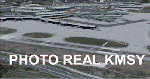
This Photo Real Scenery is a complete redo of the FSX Default KMSY Scenery using the latest version of ADE, SBuilderX scenery design tool, and Google Sketchup. I have replaced all of the default terminal buildings,added the New 2012 Concourse D expansion, new 2013 rental car garage, added gate signs to terminals A, B, C, & D, and a several nice scenery enhancements.Runways 01 and 19 are now selected by ATC for take offs and landings. I also aligned the taxiways and airport aprons to match Google & Yahoo satellite imagery. I hope you enjoy the scenery.
| Filename: | KMSY__Photo_Real_Scenery_V30___New_Orleans_Intl_Ai.zip |
| License: | Freeware |
| Added: | 24th November 2011, 08:02:17 |
| Downloads: | 4,257 |
| Author: | By Glenn Johnson |
| Size: | 26.45 MB |
| Category: Flight Simulator 2004 - Scenery | |
| LTBM Isparta, Turkey |
|
Images related to this file:
File Description:
Googly scenery for LTBM Isparta, Turkey - a small airport for which nothing more than a runway has been provided in Flight Simulator 2004. These scenery files add the apron, taxiways, buildings and other airport features so that you and your "AI" traffic can land, taxi, park and take off in a realistic manner.
The airport appears to used mainly for occasional tourism flights, particularly traffic to and from Iran.
The scenery does not purport to be ultra-accurate. Based on high-detail satellite imagery from Google Earth, the layout is proportionally correct but the added airport features, such as buildings, are built from default Microsoft objects and add-on libraries so will not look like the real thing.
You are not obliged to download and install any additional scenery libraries, but to enjoy this scenery in its entirety, you may wish to. It will work fine, with or without.
[File re-uploaded at request of AVSIM]
| Filename: | LTBM_Isparta_Turkey.zip |
| License: | Freeware |
| Added: | 26th June 2010, 13:53:59 |
| Downloads: | 1,558 |
| Author: | John Hinson |
| Size: | 88.64 KB |
| Category: Prepar3D V1-4 - Miscellaneous Files | |
| Locator for Henrik Nielson's Global AI ship traffic as July 2017 |
|
Images related to this file:
File Description:
This is a program that can help you find the many vessels in Henrik Nielsens' wonderful "Global A.I. Ship Traffic".
It covers the latest download, Version 2 and all updates up to July 2017..
It displays the routes on Google Earth, the route number and a list of the ships that can be found on that route.
There is a separate file containing their departure and arrival times on each of the routes, with instructions on how you can locate them. There is also a full list of the names and types of all the ships that are in the program.
For best results I recommend using my program with the "Little Navmap" program. Little Navmap displays all the AI ships and more in an approximate forty mile area around your aircraft. It is a navigation program all by its self.
See "Installation" doc for details where to find it.
This download was created by Carl Vokes.
| Filename: | Locator_for_Henrik_Nielsons_Global_AI_ship_traffic.zip |
| License: | Freeware |
| Added: | 18th July 2017, 03:54:08 |
| Downloads: | 607 |
| Author: | Carl Vokes |
| Size: | 9.72 MB |
| Category: Flight Simulator 2004 - Scenery | |
| WRRB Bima/Mohammad Salahuddin, Indonesia |
|
Images related to this file:
File Description:
Googly scenery for WRRB Bima/Mohammad Salahuddin, Indonesia. In Flight Simulator
2004 little is provided other than a runway at this small domestic airport,
although in the real world it sees regular local flights from airlines
such as Merpati Nusentara and Pelita Air Service. These scenery files add aprons,
taxiways, buildings and other airport features to Flight Simulator's limited
representation and allow "AI" traffic to land, taxi, park and take off in a
realistic manner.
The scenery does not purport to be ultra-accurate. Based on high-detail satellite
imagery from Google Earth, the layout is proportionally correct but the added
airport features, such as buildings, are built from default Microsoft objects
and add-on libraries so will not look exactly like the real thing.
You are not obliged to download and install any additional scenery libraries,
but to enjoy this scenery in its entirety, you may wish to. It will work fine,
with or without.
[File re-uploaded at request of AVSIM]
| Filename: | WRRB_BimaMohammad_Salahuddin_Indonesia.zip |
| License: | Freeware |
| Added: | 15th June 2010, 01:03:28 |
| Downloads: | 1,931 |
| Author: | John Hinson |
| Size: | 65.89 KB |
| Category: Flight Simulator 2004 - AFCAD Files | |
| EGDL RAF Lyneham, England, UK |
|
Images related to this file:
File Description:
These AF2 files are based on the file from David Mackie's RAF Lyneham scenery. However, they are also fully compatible with the default. They have been modified with guidance from various aerial photographs (eg. Google Earth etc). I have tested them with and without the Justflight VFR photographic scenery, and all the main airfield features have been aligned accordingly. So whatever combination of scenery you have on your system, there is a suitable afcad for you included within this release.
It is FULLY compatible with the UK Military AI Project releases and many others eg. Ed Kooymans, MAIW etc. My motivation for this update was primarily to provide a better looking airfield for users of my Air Charter Express package, available from Avsim (extended search: author "Dan Foster", sort by release date). But given the lack of decent Lyneham AF2 files that can adequately handle the RAF Hercules component, I hope this release will appeal to a much wider base.
| Filename: | EGDL_RAF_Lyneham_England_UK.zip |
| License: | Freeware |
| Added: | 5th May 2010, 22:02:56 |
| Downloads: | 702 |
| Author: | Dan Foster |
| Size: | 320.72 KB |
| Category: Flight Simulator 2004 - Scenery | |
| OPGD Gwadar International, Pakistan |
|
Images related to this file:
File Description:
Googly scenery for OPGD Gwadar International, Pakistan. In Flight Simulator
2004 only general aviation parking is provided at this so-called international airport but in the real world it is served two or three times a day by Airbii of Airblue and ATRs of Pakistan International Airways. These scenery files improve or add
aprons, taxiways, buildings and other airport features to Flight Simulator's limited
representation and allow "AI" traffic to land, taxi, park and take off in a realistic
manner.
The scenery does not purport to be ultra-accurate. Based on high-detail satellite
imagery from Google Earth, the layout is proportionally correct but the added
airport features, such as buildings, are built from default Microsoft objects
and add-on libraries so will not look like the real thing.
You are not obliged to download and install any additional scenery libraries,
but to enjoy this scenery in its entirety, you may wish to. It will work fine,
with or without.
[File re-uploaded at request of AVSIM]
| Filename: | OPGD_Gwadar_International_Pakistan.zip |
| License: | Freeware |
| Added: | 15th May 2010, 23:51:51 |
| Downloads: | 170 |
| Author: | John Hinson |
| Size: | 58.09 KB |
| Category: Flight Simulator X - AFCAD Files | |
| Camden County Airport (19N), NJ |
|
File Description:
Located 01 miles SW of Berlin, New Jersey on 75 acres of land, Camden County Airport is a small general aviation airport privately owned by Albion Airport, Inc. The airport can handle small commuter planes (like the Cessna 208B) as well as small GA craft. Tiedowns are available on both the grass turf at the west end of the airport and the tarmac on the east end. Fuel is only available on the tarmac - park next to the fuel trucks. Trees are summer time ONLY.
Scenery constructed with use of Google Maps images/streetview, the author has not been there in person.
This scenery is meant to be used in conjunction with MegaScenery Earth New Jersey/Delaware 004. It is not required, but apron use is minimized to allow satellite scenery to show through as much as possible, and objects are placed based on the MSE textures - lack of it may make scenery look out of place.
| Filename: | Camden_County_Airport_19N_NJ.zip |
| License: | Freeware |
| Added: | 8th October 2010, 14:04:03 |
| Downloads: | 243 |
| Author: | Drew Sikora |
| Size: | 944.87 KB |
© 2001-2026 AVSIM Online
All Rights Reserved
Privacy Policy |