
Where Flight Simulation Enthusiasts Gather from Around the World!
AVSIM Library - Search Results

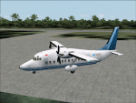
| Category: Flight Simulator X - AFCAD Files | |
| KHSV - Updated |

|
File Description:
This is the update of my previous FSX AFCAD for the default airport KHSV (Huntsville-Intl-Jones-Airport) located at Huntsville, Alabama. The AFCAD was modified using ADE v1.37 and includes changes per FAA charts, and as seen from above using Google Earth. The original control tower has been removed, a helipad with night lights and some static aircraft have been added in its place. The real airport does not have a helipad. Also I added a Fire Station and roadways like the real airport. Additional information is included in the AFCAD readme!.txt zip file. This AFCAD has not been tested in Flight Simulator 2004 and you do not need my previous KHSV files for this AFCAD update to work.
| Filename: | KHSV__Updated.zip |
| License: | Freeware |
| Added: | 3rd July 2011, 03:16:57 |
| Downloads: | 375 |
| Author: | Leroy Mears |
| Size: | 32.68 KB |
| Category: Flight Simulator 2004 - AFCAD Files | |
| WAOI/WRBI Pangkalanbun/Iskandar, Indonesia |
|
Images related to this file:
File Description:
Googlyafcad A&F Data file for Iskandar, based on Google Earth satellite data. Iskandar is a small domestic airport in Pangkalanbun, on Borneo, Indonesia. Unfortunately, Microsoft have provided no facilities in Flight Simulator 2004 at this airport, which is served by a few flights a day operated by small airlines like Deraya Air Taxi and Indonesia Air Taxi. These files will allow you and your "AI" traffic to land, taxi, park and take off in a realistic manner.
Like many airports in Indonesia, the ICAO code has changed in recent years. Microsoft Flight Simulator 2004 uses the old code (WRBI) and these files allow you to continue using that code or change to the new one. [File re-uploaded at request of AVSIM]
| Filename: | WAOIWRBI_PangkalanbunIskandar_Indonesia.zip |
| License: | Freeware |
| Added: | 20th June 2010, 10:52:36 |
| Downloads: | 500 |
| Author: | John Hinson |
| Size: | 62.39 KB |
| Category: Flight Simulator X - Scenery | |
| LSZN Hausen am Albis, Switzerland for FSX/P3D |
|
Images related to this file:
File Description:
LSZN Hausen am Albis is one of the "white spots" in the FSX/P3D. This airfield does not exist in the standard scenery of FSX/P3D.
Information about the airfield you can find here (only in german):
http://www.fgho.ch/
This scenery is designed in a quite detailled way. All important buildings are made new by myself or converted from old FS9-objects from the FS9-scenery of Andreas Aegi.
The suroundings of the airfield are adapted by new landclasses fitting the real situations according to the satellite photos of GOOGLE Earth.
Also the mesh of the airfield is adapted to the real mesh as it is assigned in the charts..
There are Photobackgrounds for FS-standardscenery and the payware-scenery “Switzerland ProXâ€.
| Filename: | LSZN_Hausen_am_Albis_Switzerland_for_FSXP3D.zip |
| License: | Freeware |
| Added: | 15th October 2017, 04:23:38 |
| Downloads: | 1,419 |
| Author: | Wolfgang Allers |
| Size: | 221.53 MB |
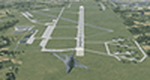
| Category: Flight Simulator X - AFCAD Files | |
| USSS - Koltsovo Airport - Yekaterinburg, Russia |
|
File Description:
Yekaterinburg, Koltsovo International Airport USSS, serves Yekaterinburg, Russia. The airport serves 4.2 million passengers a year. It has been a civil airport since 1943.
I have changed the FSX stock airport in several ways. Shifted the angle and position on RWY 08R-26L and re-aligned the ILS. Added ILS to RWY 08L-26R. Corrected the parking positions in line with charts. I have used ADE and Google Earth to achieve these corrections. I have also added several generic buildings to reflect the real airport.
You should download the brilliant car park package by Sidney Schwartz, modified my Martin Gossman at Owls Nest. Also the great lights package by Jim Dhaenens. Both can be found on AVSIM and other good flight sim libraries.
| Filename: | USSS__Koltsovo_Airport__Yekaterinburg_Russia.zip |
| License: | Freeware |
| Added: | 23rd August 2016, 21:50:17 |
| Downloads: | 1,502 |
| Author: | Mike Major |
| Size: | 5.17 MB |
| Category: Flight Simulator 2004 - Scenery | |
| Cavanaugh Bay 66S Idaho Airport |
|
File Description:
Priest Lake in Idaho is described by their Chamber of Commerce as "...a magnificent 23,000 acre azure lake nestled beneath the majestic Selkirk Mountains — without question, one of the most beautiful wilderness areas you’ll ever see." Cavanaugh Bay is a grass strip right on the lake, with lodges (there's one right next to the end of the runway), campgrounds and boat/plane docks nearby. I think I was able to make a fair approximation of the real thing, based on Google Earth. If you're flying something that floats, choosing RWY S or RWY E from the FS9 airport menu will park you conveniently at a floatplane dock. This scenery was designed for use with Ultimate Terrain USA and has not been tested with the default FS9 scenery.
| Filename: | Cavanaugh_Bay_66S_Idaho_Airport.zip |
| License: | Freeware |
| Added: | 14th July 2008, 13:38:40 |
| Downloads: | 608 |
| Author: | Sidney Schwartz |
| Size: | 654.43 KB |
| Category: Prepar3D V1-4 - Scenery | |
| P3Dv4 Maryland State Police Aviation Bases |
|
File Description:
The Maryland State Police (MSP) Aviation Command operates seven AW139 from bases across the State. The current P3Dv4 stock scenery does not include all of the correct layouts at the bases. TRP1 at KMTN, TRP2 at KADW, TRP3 at KFDK, TRP4 at KSBY, TRP5 at KCBE, TRP6 at KESN and TRP7 at 2W6. This download does not include KADW nor KMTN as they have the correct default layout. Included are five or the seven locations needed to operate geographically correct.
These files are base entry level creation to put the MSP helipads in their correct location. They do also update the taxiways and runways to Google Earth data in November 2024. Some fixed wing start locations were removed. Enjoy and provide feedback.
| Filename: | P3Dv4_Maryland_State_Police_Aviation_Bases.zip |
| License: | Freeware |
| Added: | 11th November 2024, 17:25:51 |
| Downloads: | 29 |
| Author: | Sean Harrison |
| Size: | 43.95 KB |
| Category: Flight Simulator X - Scenery | |
| EPKS Poznan-Krzesiny AB Poland Scenery Package with AI Blk52+ CFT F-16s |
|
Images related to this file:
File Description:
This is a complete "plug and play" scenery package for EPKS Poznan-Krzesiny AB that includes two squadrons of "custom painted" Poland AF AI Block 52+ CFT F-16's!
Using Airport Design Editor, MAIW's Scenery Objects, and Google Earth for reference, I did my best to re-create EPKS Poznan-Krzesiny AB for FSX. Since info online about the base is limited, I had to guess about a few things, like taxiway designations and the frequency for the ILS, so apologies for any errors due to that. The 3-ELT and 6-ELT F-16s both have assigned parking in aircraft shelters, but I also created several other "assigned parking areas" around the base for you to add other AI aircraft as you wish.
| Filename: | EPKS_PoznanKrzesiny_AB_Poland_Scenery_Package_with.zip |
| License: | Freeware |
| Added: | 10th April 2022, 16:45:51 |
| Downloads: | 541 |
| Author: | Daniel W Gregory |
| Size: | 54.4 MB |
| Category: Flight Simulator X - Scenery | |
| KLUA - Luray Caverns Airport - Luray, Virgina, USA |
|
Images related to this file:
File Description:
Luray Caverns Airport (ICAO: KLUA, FAA LID: LUA, formerly W45) is a public use airport located two nautical miles (4 km) west of the central business district of Luray, a town in Page County, Virginia, United States. The airport is owned by the Town of Luray and Page County.It is included in the National Plan of Integrated Airport Systems for 2011-2015, which categorized it as a general aviation airport.
Added taxiways and aircraft parkng along with custom buildings. Created with Airport Design Editor by ScruffyDuck Software using current FAA documentation and Google Earth measurements, this package offers a replacement for FSX's stock airport. All these enhancements are as close to the real airport as I can get with stock library objects and custom buildings.
| Filename: | KLUA__Luray_Caverns_Airport__Luray_Virgina_USA.zip |
| License: | Freeware |
| Added: | 29th November 2014, 14:11:35 |
| Downloads: | 314 |
| Author: | Wayne Roberts |
| Size: | 339.07 KB |
| Category: Flight Simulator X - Utilities | |
| FSXPilot 1.0 |
|
File Description:
FSXPilot 1.0 (FSXP) - the unique and standalone autopilot, EFIS, navigation tool and flightgenerator for planes and helicopters, now goes FSX !
FSXP is a standalone FSX (Simconnect) client application which offers: Reliable autolandings with any of the standard FSX planes. Helicopter autopilot with improved slow-fly characteristics. Aerobatic flight generator. Loops, rolls, dives, cubanic eights, low level inverted, tailspins, and more in flightplans. Smoke effects. Inverted flight auto-button. Advanced single button click screenshot camera (JPG, GIF, PNG, TIF, BMP), auto-thumbnails. Google Earth connector. MS Access <-> FS2004 database connector. Extended status reports. Finds best ILS runway according to length and surface wind. Landing evaluation. Sounds from flightplans. MP3 player from command line interface. Latest AIRAC included. Find all info at http://www.fsxpilot.com
| Filename: | FSXPilot_10.zip |
| License: | Shareware, time limited |
| Added: | 25th October 2006, 19:58:16 |
| Downloads: | 7,784 |
| Author: | Rudolf Bumm |
| Size: | 6.15 MB |
| Category: Flight Simulator X - Scenery | |
| F45 - North Palm Beach County General Aviation Airport - West Palm Beach, Florida (USA) |
|
Images related to this file:
File Description:
North Palm Beach County Airport, located northwest of West Palm Beach, Florida, was opened in 1994 as a designated reliever for KPBI. All of the buildings have been custom modeled in accordance with information available on the internet including Microsoft Bing birdseye views. The airport layout and landclass changes are in accordance with Google Earth imagery.
If you have Jim Dhaenens' lightobj.bgl installed, apron lighting will be included, and if you have KB_static_aircraft_FSX installed (available at www.kb-sim.com/screens_static_aircraft.html), additional parked aircraft will be visible.
The layout of scenery is optimized for use with Ultimate Terrain X-USA. There is no FAA airport diagram for this airport, but a taxiway diagram provided by the local Airport Authority is included in this package.
| Filename: | F45__North_Palm_Beach_County_General_Aviation_Airp.zip |
| License: | Freeware |
| Added: | 22nd August 2013, 20:48:03 |
| Downloads: | 1,150 |
| Author: | Art Poole |
| Size: | 1.27 MB |
© 2001-2026 AVSIM Online
All Rights Reserved
Privacy Policy |