
Where Flight Simulation Enthusiasts Gather from Around the World!
AVSIM Library - Search Results

| Category: Flight Simulator X - Scenery | |
| Collique Airport (Peru) SPOL |

|
Images related to this file:
File Description:

Scenery for Collique Airport (SPOL) PERU,done using ADE9X(v2)based on google satellite maps,with additional scenery objects like flying birds ect.
| Filename: | Collique_Airport__Peru_SPOL.zip |
| License: | Freeware |
| Added: | 8th January 2010, 20:55:13 |
| Downloads: | 1,201 |
| Author: | Antoine Calleja,globusworld.net |
| Size: | 379.47 KB |
| Category: Flight Simulator 2004 - AI Flight Plans | |
| Delta Air Lines Winter 2009 Flightplans (January 5 - 11, 2009) |
|
File Description:
Comprehensive Delta and Delta Connection flight plans effective January 5, 2009. Contains numerous additions and changes. The most realistic Delta flight plans on earth! 99.99% accurate!
| Filename: | Delta_Air_Lines_Winter_2009_Flightplans_January_5_.zip |
| License: | Freeware |
| Added: | 8th January 2009, 00:48:27 |
| Downloads: | 986 |
| Author: | Jeremy Crowther |
| Size: | 187.54 KB |
| Category: Flight Simulator 2004 - Miscellaneous Files | |
| Planetary Textures |
|
File Description:
These textures will replace the default Earth textures when zoomed out in Top-Down view to one of our solar system's celestial bodies. Textures for all planets in the solar system are included (except Earth): Mercury, Venus, Mars, Jupiter, Saturn, Uranus, Neptune, and Pluto, as well as the four largest moons of Jupiter: Ganymede, Callisto, Io, and Europa. There is also a texture set for the Sun and the Earth's moon.
| Filename: | Planetary_Textures.zip |
| License: | Freeware |
| Added: | 2nd March 2006, 15:04:54 |
| Downloads: | 1,068 |
| Author: | Scott Armstrong |
| Size: | 11.73 MB |
| Category: Flight Simulator X - Scenery | |
| California Central Coast Scenery for FSX with Megascenery Earth (Default Mesh Terrain) |
|
Images related to this file:
File Description:
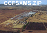
Revised 1/7/10 for upload to Avsim.COM. CCFSXMSFix is incorporated so not required.
This is an earlier version of CCC Megascenery Earth scenery that doesn't require FSGenesis Mesh Terrain. See CCFSXMSG.ZIP for the FSGenesis Mesh version.
This scenery covers the California coastal region from N36���°10' (Coalinga) to N34���°25' (Santa Barbara) and from the coast East to W119���°40'. It is a version of my previous California Central Coast scenery redesigned and expanded to work with MegaScenery Earth from PC Aviator Inc. Many airstrips in the area covered by this scenery have been added or enhanced for a total of 27 airports/airstrips in the area. Several areas of interest such as the Santa Barbara marina, Morro Bay, etc. are also included for a total of 41 points of interest. All airports/airstrips and related structures have been adjusted and realigned to conform to actual positions and dimensions as indicated by the MegaScenery satellite textures. In addition, there are 6 invisible water runways for use by AI floatplane traffic. MegaScenery California-13, -14 and -15 are required for this scenery to make sense. I also used California-12, -28 and -29 when constructing the scenery but they could be considered optional.
| Filename: | California_Central_Coast_Scenery_for_FSX_with_Mega.zip |
| License: | Freeware |
| Added: | 7th January 2010, 21:28:45 |
| Downloads: | 1,559 |
| Author: | Al Wheeler |
| Size: | 8.12 MB |
| Category: Flight Simulator X - Scenery | |
| Scenery Pokhara Airport Nepal VNPK |
|
Images related to this file:
File Description:

Scenery for Pokhara Airport Nepal VNPK,Scenery done using ADE9X based on google Satellite images,with additional animated scenery like flying birds ecc.enjoy it.
| Filename: | Scenery_Pokhara_Airport_Nepal_VNPK.zip |
| License: | Freeware |
| Added: | 5th November 2009, 21:08:13 |
| Downloads: | 2,093 |
| Author: | Antoine Calleja |
| Size: | 184.31 KB |
| Category: Flight Simulator 2004 - AFCAD Files | |
| Luxembourg - Findel (ELLX) |
|
Images related to this file:
File Description:

AFCAD2 for Luxembourg - Findel (ELLX) by A.Welter (ver 2 - 07/2006)
--------------------------------------------------------------------
Reworked on:
1 - Gate radius
2 - Airport related chart
3 - Google map view
| Filename: | Luxembourg__Findel_ELLX.zip |
| License: | Freeware |
| Added: | 18th June 2011, 16:47:10 |
| Downloads: | 250 |
| Author: | V.Mercolino - geniX Soft |
| Size: | 13.47 KB |
| Category: Flight Simulator X - AFCAD Files | |
| Cotonou Cadjehoun Airport (DBBB/COO), Benin |
|
File Description:
Completely reworked apron for Cotonou Cadjehoun Airport (DBBB/COO), Benin, according to current Google Maps satellite pictures. Designed with Airport Design Editor X 1.75.
| Filename: | Cotonou_Cadjehoun_Airport_DBBBCOO_Benin.zip |
| License: | Freeware |
| Added: | 27th November 2017, 19:36:22 |
| Downloads: | 697 |
| Author: | Yannic Brodersen |
| Size: | 8.11 KB |
| Category: Microsoft Flight Simulator (2020) - Scenery | |
| Airport Saglek CYSV in Canada, Labrador |
|
File Description:
Saglek Airport CYSV (Route additions to radar etc.)
The airport is located north of New Fourdland in Canada, there is a radar station on the mountain near the Atlantic.
In 1945, he had research on BPS.
The scenery comes from information collected from Google Earth and other images.
Runway 17 has an ILS approach on frequency 110.10.
Runway 35 also has an ILS approach on frequency 112.10.
The landing is quite critical because we are close to the ground.
ATC control is active for approaches and ground service.
Special Warning:
If you have another CYSV scene in Community, please delete it or remove it from the Community.
Installation: unzip the folder: rd-airport-cysv-saglek-v4.zip and place the rd-airport-saglek folder in the community.
| Filename: | Airport_Saglek_CYSV__in_Canada_Labrador.zip |
| License: | Freeware |
| Added: | 6th November 2023, 15:25:17 |
| Downloads: | 25 |
| Author: | Regis Dassylva |
| Size: | 5.9 MB |
| Category: Microsoft Flight Simulator (2020) - Scenery | |
| Saglek Airport CYSV |
|
File Description:
Saglek Airport CYSV (Route additions to radar etc.)
The airport is located north of New Fourdland in Canada, there is a radar station on the mountain near the Atlantic.
In 1945, he had research on BPS.
The scenery comes from information collected from Google Earth and other images.
Runway 17 has an ILS approach on frequency 110.10.
Runway 35 also has an ILS approach on frequency 112.10.
The landing is quite critical because we are close to the ground.
ATC control is active for approaches and ground service.
Special Warning:
If you have another CYSV scene in Community, please delete it or remove it from the Community.
Installation: unzip the folder: rd-airport-cysv-saglek-v4.zip and place the rd-airport-saglek folder in the community.
| Filename: | Saglek_Airport_CYSV.zip |
| License: | Freeware |
| Added: | 6th November 2023, 15:28:32 |
| Downloads: | 31 |
| Author: | Regis Dassylva |
| Size: | 5.47 MB |
| Category: Flight Simulator 2004 - AFCAD Files | |
| Woodvale (EGOW) Ground Improvements (v1.0) |
|
File Description:
Includes: Military dispersals, light aircraft park, re-designation of runways to current format, runway placement, frequency changes, general taxiway adjustments, inclusion of Merseyside police helipad, and much more. I'd call it a little more than an improvement over Microsoft's 'two-runway-no-taxiway' version. Something for us Air Cadets out there! I've used my real-world charts and Google Earth to apply areas to the default AFCAD. I have noticed that there is an unused dispersal from its war-era on the south-side, but I haven't included it because it is not very significant - but if I notice any issues later on I'll make an effort to put it in for a little eye-candy and realism. See Readme file for more details...enjoy!
| Filename: | Woodvale_EGOW_Ground_Improvements_v10.zip |
| License: | Freeware, limited distribution |
| Added: | 12th October 2008, 20:27:40 |
| Downloads: | 254 |
| Author: | David Hunter |
| Size: | 40.77 KB |
© 2001-2026 AVSIM Online
All Rights Reserved
Privacy Policy |