
Where Flight Simulation Enthusiasts Gather from Around the World!
AVSIM Library - Search Results

| Category: Prepar3D V1-4 - Scenery | |
| LPCO - Aeródromo Municipal Bissaya Barreto ou Aeródromo de Coimbra - V 1.3 |

|
File Description:
This scenario fixes the terrain texture issue from the previous version (LPCO - Aerodromo Municipal Bissaya Barreto ou Aerodromo de Coimbra, V1.1).
It is a Portuguese airfield, located next to the city of Coimbra.
It has a runway (16/34) in asphalt, measuring 920m x 30m and located at an altitude of 174m (570 feet).
The airfield has security at night, AFIS service (Aerodrome Flight Information Service), from sunrise to sunset, flight planning room, lighting for night flights, and AVGAS 100 LL fuel.
It also has an Aerodrome Beacon of the Locator type whose frequency is 426.00Khz (code "CB").
This scenario was only tested on P3Dv4.5.
| Filename: | LPCO__Aerdromo_Municipal_Bissaya_Barreto_ou_Aerdro.zip |
| License: | Freeware |
| Added: | 23rd March 2023, 21:46:34 |
| Downloads: | 109 |
| Author: | Eduardo Puelker |
| Size: | 11.4 MB |
| Category: Flight Simulator X - Scenery | |
| LEBB - Bilbao Airport - Bilbao, Spain |
|
Images related to this file:
File Description:
This airport update is made only for FSX with two optional files, one version with the Crosswind runway activated and in full operation where both runways will be used for takeoff and landing and one version as the default runway operation: terminal north completely remodeled, airlines assigned to their gates, ILS added to runway 12, extra GA parking, helipad with start location, taxiways and taxi signs updated to the latest charts, extra fuel trucks, support vehicle roads rebuilt and many other scenery objects added, airport views are from the roof of the control tower (when in tower view) please view the readme before installation.
| Filename: | LEBB__Bilbao_Airport__Bilbao_Spain.zip |
| License: | Freeware, limited distribution |
| Added: | 21st December 2015, 09:42:56 |
| Downloads: | 16,640 |
| Author: | Craig Scott |
| Size: | 758.49 KB |
| Category: Flight Simulator X - Scenery | |
| Artic Bay Winter 2017 NEW version |
|
File Description:
This is artic bay, a small airport in Nunavut, Canada. First air operate scheduled and charter flights on a regular basis. In 2011 the airport received an update extending the runway and building bigger aprons so the ATR-500 & 300 aircraft can operate there. You can even fit a 737-200 in the airport! (not seen in real life, but with little fuel and pax it is very possible!) I made this airport using ADE with 99% accurate aprons, buildings, moved location and custom AI. There is one small issue, in the dark the main terminal building goes very dark, so try and do day time flights. Requires UTX Canada
| Filename: | Artic_Bay_Winter_2017_NEW_version.zip |
| License: | Check within download |
| Added: | 12th December 2017, 23:24:26 |
| Downloads: | 467 |
| Author: | Ollie Seaward |
| Size: | 2.76 MB |
| Category: Flight Simulator X - Utilities | |
| FS2004/FSX Flight Analyzer, Logbook Utility V4.09 |
|
Images related to this file:
File Description:
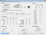
FS2004/FSX Flight Analyzer Utility V4.09
Flight Data Recorder - Logbook.
NOW WITH STATISTICS TOP 5 AIRPORTS, CITIES AND COUNTRIES.
Very easy to use, just make a flight plan in the simulator or in this utility.
What this program do:
- quickly change the settings of FSX/Fs2004, such as time, date, fuel, weight, traffic etc.
- start a failure sytem, such as gear, flaps, engine, etc.
- freeze the time, so you can fly in a for everlasting sunset.
- runway detecting system to see wich runways are in use.
- flight analyzing/data recording from departure to parking at the gate.
- When flight analysis is finished you can print a report, the report is automaticly saved as pdf File.
- graphical landingchart.
- record all your flights
- quickly look to your FSX display settings (only FSX) and change them even before the flight simulator is running.
- After a flight is finished FsQC saves your flight automaticly as 'FsQC last Flight', so you can continue the next day or hour.
Flight analysis start recording at the moment when you begin taxiing.
It gives you huge information such as:
- takeoff- and landing-weight.
- takeoff- and landing-roll in m. and ft.
- separate fuel consumption in taxi, climb, cruise and descent.
- maximum banking in flight.
- which speed you using the flaps and gear.
- when autopilot on or off.
- vertical speed on touchdown.
- reverser set after landing.
- wich speed you cancel reverser.
- bouncing at landing.
- graphical landingchart.
- and lots of more.
You can better look the example of the pdf document located in the 'Flight Reports' folder.
Logbook records:
- fuel consumption.
- payload.
- distance.
- number of different airports.
- flight hours.
- landings.
- flaps.
- speed.
- and lots of more.
- quickly show touchdown wind information in a picture.
- quickly show the graphical landing chart.
- Now with statistics: top 5 Countries, Cities and Airports
Requirements:
Computer with vista or higher and internet access.
Microsoft .net framework 4.6 or higher.(free download on microsft.com)
Flightsimulator FSX or 2004 and FSUIPC installed.
Note: requires paid activation for full use.
Register and you have 1 month free.
Program fully works without registration at airport Athens and Iraklion (Greece)
| Filename: | FS2004FSX_Flight_Analyzer_Logbook_Utility_V409.zip |
| License: | Shareware, time limited |
| Added: | 3rd March 2019, 00:20:37 |
| Downloads: | 251 |
| Author: | Evander Tholen |
| Size: | 3.35 MB |
| Category: Flight Simulator X - AFCAD Files | |
| Cross Keys Airport (17N), NJ |
|
File Description:
Located 01 miles S of Cross Keys, New Jersey on 280 acres of land, Cross Keys Airport is a small General Aviation field privately owned by Cross Keys Airport Inc. In addition to servicing GA flights, the airport also hosts a paintball field and a sky diving operation to the north of the field. For this reason, all aircraft must remain south of the runway at all times. Any aircraft with a wingspan larger than 40 feet will need to park in the turf area west of the main apron - smaller GA aircraft can pick a spot from any of the open tiedown areas. 100LL (Blue) Fuel is available by stopping next to the fuel tank on the main apron. Although it doesn't exist in real life, a patch of concrete to the west of the main apron made for a good helipad, so I included one. It is not lit at night. Trees in the surrounding forest are summer trees ONLY.
Scenery constructed with use of Google Maps images, and vague recollection by the author who went sky diving there once.
This scenery is meant to be used in conjunction with MegaScenery Earth New Jersey/Delaware 004. It is not required, but apron use is minimized to allow satellite scenery to show through as much as possible, and objects are placed based on the MSE textures - lack of it may make scenery look out of place.
| Filename: | Cross_Keys_Airport_17N_NJ.zip |
| License: | Freeware |
| Added: | 7th October 2010, 03:27:53 |
| Downloads: | 246 |
| Author: | Drew Sikora |
| Size: | 719.13 KB |
| Category: Flight Simulator 2004 - Scenery | |
| Chisasibi CSU2 in northern Quebec, Canada |
|
Images related to this file:
File Description:
Chisasibi is in northern Quebec on the east shore of James Bay, 60 miles from the corner of James Bay and Hudson Bay. Originally called Fort George and founded at the mouth of La Grande Riviere around the Hudson Bay trading post that was established in 1803, the town had to move 5 miles upstream in 1981 when the Quebec hydro project increased the flow rate of the river. The name was changed to Chisasibi at the time of the move (Chisasibi = Great River in Cree) and the population (750 as early as 1940) has now grown to around 2,000. There is a paved road east to Radisson that connects to the north-south James Bay road, which was built at the time of the hydro project work. The original Fort George airport runway is still visible but not usable, just south of the original town site. Chisasibi airport is to the west of the new town, and the gravel runway is 3,792 feet long and aligned 14/32, which is approximately parallel to the river. There is officially no fuel available, but there is JetA on site for Air Creebec in a tank protected by used fuel drums (filled with sand?). The terminal and the garage building are both relatively new; the terminal dates from 2002 and has unusual touches. There are two AI flights by Air Creebec each day plus other private planes.
| Filename: | Chisasibi_CSU2_in_northern_Quebec_Canada.zip |
| License: | Freeware, limited distribution |
| Added: | 27th February 2013, 21:24:47 |
| Downloads: | 287 |
| Author: | Roger Wensley |
| Size: | 2.79 MB |
| Category: Flight Simulator X - Gauges | |
| V-One Gauge for Boeing 727-100/200/F (Complete) |
|
Images related to this file:
File Description:
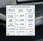
New features in this version are in indicated in '[ ]'.
Twenty call-outs sounds integrated into gauge [13 new call-outs].
Take-off V-Speeds calculated for Flaps 5, 15, or 25 with temperature and altitude adjustments.
[Take-off speed bugs and Command speed bug automatically set for: V1/Vr, V2, V2 + 15].
[Flaps-up maneuvering speed (clean speed) bug set after flaps-up].
Optimum altitude and optimum EPR (EPR calc for M.80) are continually calculated.
Gross Weight overage will display in 'red' text. Tooltip indicates overweight value (LB/KG).
Take-off trim calculated for current gross weight.
Maximum Climb Thrust (MCT) calculated based on current TAT temperature.
[Current EPR displayed adjacent to MCT for ease of use during climb phase].
Display units can be toggled between LB and KG (default LB).
Outside air Temperature can be toggle between Fahrenheit and Celsius.
Resettable fuel use.
Resettable flight timer.
[Selectable Vref landing configurations, Vref30 (default) or Vref40].
[Approach / landing speed bugs and Command speed bug automatically set for: Vref, Vref + 5, Vref + 15].
ZFW, Fuel, CG, Gross Weight and Barometric Pressure MSL (QNH) displayed.
['Barometer Set' call-out occurs when pressing keyboard letter 'B' (V-One gauge must be open)].
[Airspeed gauge enhanced: CMD speed bug colorized orange and notch added for visibly of tick marks below].
[Decision Height adjustment now on Data Card in hidden click-spot located on upper right corner].
[Now installation to a single location will work for all variants].
| Filename: | VOne_Gauge_for_Boeing_727100200F_Complete.zip |
| License: | Freeware, limited distribution |
| Added: | 28th January 2013, 11:30:53 |
| Downloads: | 1,512 |
| Author: | Paul Tally |
| Size: | 3.55 MB |
| Category: Flight Simulator X - Gauges | |
| V-One Gauge for Milviz Boeing 737-200 v2.0 |
|
File Description:
The following changes are in this version release:
1) All pilot/co-pilot call-outs replaced
2) V-One XML code and sound file logic updated
3) Altitude Call-Out XML code re-written & optimized
4) Corrected setting of Airspeed Cursor when SP177 is in use during approach phase
5) Added Call-out sound toggle for: 'All', 'Altitude' or 'Off' (box in upper right of Data Card)
6) Added 'Current %N1' display to Data Card
List of features: Approximately 40 sounds integrated into gauge. Take-off V-Speeds calculated for Flaps 1, 2, 5, 10, 15 or 25 including temperature and altitude correction. Take-off speed bugs and command speed bug automatically set for: V1, Vr, V2, V2 + 15 and flaps-up maneuvering speed (clean speed). Optimum altitude and optimum EPR (EPR calc for M.74) continually calculated. Flap mis-configuration is displayed in text. Tooltip indicates overweight value (LB/KG). Take-off trim calculated for current gross weight. Current Altitude, EPR, Speed (knts), Flaps and Trim displays via toggle. Display units can be toggled between LB and KG (default LB). Re-settable flight timer. Re-settable fuel use. Selectable Vref landing configurations, Vref15, Vref30 (default) or Vref40. Approach / landing speed bugs and Command speed bug automatically set for: Vref, Vref + 5, Vref + 15 and flaps-up maneuvering speed (clean speed). ZFW, Fuel, CG, Gross Weight and Barometric Pressure MSL (QNH) displayed.
| Filename: | VOne_Gauge_for_Milviz_Boeing_737200_v20.zip |
| License: | Freeware, limited distribution |
| Added: | 1st November 2015, 18:35:29 |
| Downloads: | 2,443 |
| Author: | Paul Tally |
| Size: | 4.11 MB |
| Category: Flight Simulator X - Utilities | |
| FS2004/FSX/Prepar3D Flight Analyzer/Logbook Utility V6.14 |
|
File Description:
FS2004/FSX/Prepar3D Flight Analyzer/Logbook Utility V6.14 Flight Data Recorder - Logbook. Now a few bugs are fixed. Very easy to use, just make a flight plan in the simulator or in this utility. What this program does: quickly change the settings of P3D/FSX/Fs2004, such as time, date, fuel, weight, traffic etc.; start a failure sytem, such as gear, flaps, engine, etc.; freeze the time, so you can fly in a for everlasting sunset; runway detecting system to see wich runways are in use; flight analyzing/data recording from departure to parking at the gate; When flight analysis is finished you can print a report, the report is automaticly saved as pdf File. By Evander Tholen.
| Filename: | FS2004FSXPrepar3D_Flight_AnalyzerLogbook_Utility_V.zip |
| License: | Shareware, limited functionality |
| Added: | 21st January 2020, 17:43:48 |
| Downloads: | 193 |
| Author: | Evander Tholen |
| Size: | 3.43 MB |
| Category: Flight Simulator X - AFCAD Files | |
| 94K Cassville Municipal Airport |
|
Images related to this file:
File Description:
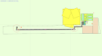
This is my home airport; 94K in Cassville, MO. It isn't a big airport, but they have any fuel you want (as long as it's 100LL) and plenty of parking (if no one beat you to it)! I've fixed the apron, added a parking spot for medium GA, cleaned up the west (RWY9) turn-around, adjusted the fencing, added some hangars and some treats, moved the beacon tower and the east windsock to a more realistic location, edited the tower view to provide a good view of the airport, added some trees and birds, etc. Nothing over the top, just some corrections and homey touches. Please read the READ ME file. Enjoy!
| Filename: | 94K_Cassville_Municipal_Airport.zip |
| License: | Freeware |
| Added: | 1st September 2010, 08:27:55 |
| Downloads: | 202 |
| Author: | Jeremy G. Burch |
| Size: | 161.52 KB |


© 2001-2026 AVSIM Online
All Rights Reserved
Privacy Policy |