
Where Flight Simulation Enthusiasts Gather from Around the World!
AVSIM Library - Search Results

| Category: Flight Simulator 2004 - Aircraft Repaints, Textures and Modifications | |
| DIAS Air MD-11 Freighter |

|
File Description:
These are DIAS AIR International Virtual Airlines (www.diasair.gr) fictional textures for the astonishing PMDG MD-11F addon for FS9!!!. Includes the registration SX-CCA named "TALOS".DIAS AIR is an international virtual company established in 2006, by an Airline Captain, Pilot Instructor and Examiner, only for very advanced members of the Flight Simmers Community. The organization utilises a sophisticated model for the simulation of the Economical & Technical environment of a real Aviation Company. Our pilot members are paid by an exclusive model using the "OCTANES" payment system, and not only! Our flight operations are global and cover all 5 continents. Our fleet includes 35 different types of aircraft for Microsoft Flight Simulator™. The dynamic site is updated on a daily basis. Our pilot ranks begin from Junior First Officer up to Senior Captain of the Company. We also use a private FORUM and a TeamSpeak Server for our member pilots. We operate only On-Line at our PRIVATE FS Server, at IVAO and VATSIM networks.Please note that in the screens you can see the upcoming Kerkyra MEGA Scenery by GAP (www.greekairportsproject.gr). Stay tuned...
| Filename: | DIAS_Air_MD11_Freighter.zip |
| License: | Freeware, limited distribution |
| Added: | 8th January 2009, 13:36:18 |
| Downloads: | 240 |
| Author: | Nicholas Maggioros |
| Size: | 8.43 MB |
| Category: Flight Simulator 2004 - Scenery | |
| Kogd-Ogden,Utah |
|
Images related to this file:
File Description:
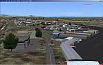
KOGD-Ogden,Ut Take your sailboat to the Great Salt Lake inland sea or hike the many mountains and enjoy the vistas offered atop the lofty peaks. Visit the quiet mountain valley town of Eden to the east of KOGD with its annual balloon festival and summer fun on Pineview dam or spend the day shopping the shops of Brigham City to the north or Salt Lake City to the south. Fly over the Great Salt Lake to the west. See the Ogden airport come alive with this must have add-on. With the help of Google Earth and FS Earth I have recreated the Ogden airport, with its new taxiway A (from a site visit), and the surrounding cities and towns to look as real as possible. Made with Ultimate Terrain, but the airport should be ok with default FS9. (No guarantee though ;-) The scenery enhancements were made with Ultimate Terrain in place. I modified the landclass to look more like the real thing. The airport is very close to a exact replica of KOGD! The crane by the tower was there when I took the pictures so I included it.
| Filename: | KogdOgdenUtah.zip |
| License: | Freeware |
| Added: | 15th December 2009, 00:45:07 |
| Downloads: | 725 |
| Author: | Alan C. Heiner |
| Size: | 15.59 MB |
| Category: Flight Simulator 2004 - Scenery | |
| Kogd-Ogden,Utah |
|
Images related to this file:
File Description:
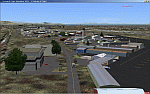
KOGD-Ogden,Ut
Take your sailboat to the Great Salt Lake inland sea or hike the many mountains and enjoy the vistas offered atop the lofty peaks. Visit the quiet mountain valley town of Eden to the east of KOGD with its annual balloon festival and summer fun on Pineview dam or spend the day shopping the shops of Brigham City to the north or Salt Lake City to the south. Fly over the Great Salt Lake to the west.
See the Ogden airport come alive with this must have add-on. With the help of Google Earth and FS Earth I have recreated the Ogden airport, with its new taxiway A (from a site visit), and the surrounding cities and towns to look as real as possible.
Made with Ultimate Terrain, but the airport should be ok with default FS9. (No guarantee though ;-)
The scenery enhancements were made with Ultimate Terrain in place. I modified the landclass to look more like the real thing. The airport is very close to a exact replica of KOGD! The crane by the tower was there when I took the pictures so I included it.
| Filename: | KogdOgdenUtah.zip |
| License: | Freeware |
| Added: | 20th January 2009, 13:42:09 |
| Downloads: | 1,344 |
| Author: | Alan C. Heiner |
| Size: | 15.59 MB |
| Category: Flight Simulator 2004 - Panels | |
| Grumman Albatross version 2.1 Panel |
|
Images related to this file:
File Description:
FS2004 Grumman Albatross HU-16 version 2.1
Greg Pepper Michael Verlin
Panel Package
Along with the modifications I've made to Greg Pepper's wonderful Albatross, I felt that a upgrade for the panel was overdue.
The changes consist of a revised set of primary flight instruments in keeping with the chronological period.
The airspeed gauge is part of Greg's gauge set that he provided with the aircraft.
The attitude gauge and turn indicator come from Jens Christensen's DC-6 gauge package.
The altimeter, gyro and vertical speed were designed by Scott Thomas from his Aero Commander 500 gauge package.
The Bendix King radios were designed by Pierre Fasseaux.
The KLN90 gps was designed by Ike Slack.
I've also included Rob Barendregt's Ground Handling package and the RKG Fuelstat gauge.
A few notes on using this panel:
Please read Pierre's instructions for proper operation of the autopilot before you fly.
The GPS will load the flight plan you specify from FS9.
There is a hot spot in the upper left corner of the radio stack that will close it when it isn't needed.
Michael Verlin
[email protected]
May 27, 2012
| Filename: | Grumman_Albatross_version_21_Panel.zip |
| License: | Freeware |
| Added: | 27th May 2012, 23:13:55 |
| Downloads: | 696 |
| Author: | Greg Pepper Michael Verlin |
| Size: | 9.61 MB |
| Category: Flight Simulator 2004 - Scenery | |
| Hicks Farm Field CF12 near Ottawa in Ontario, Canada |
|
Images related to this file:
File Description:
Hicks Farm is in Ontario and around 8 miles west of Rideau Valley Airpark CPL3 (which did not appear in FS9, probably because it was then mainly used by gliders, but is a post of mine). CPL3 is 15 miles south of Ottawa Airport, tucked into a right angle bend of the Rideau River. Ultimate Terrain puts the river into place, and I am not sure of how or if either CPL3 or CF12 work without UT, maybe somebody can let me know. Fly west from CPL3 along the river and Hicks Farm will be on the south side. It has a (mainly) grass runway 34/16 with a section of asphalt and totals some 5,500 feet overall. Alan, the owner of Hicks Farm, is in his mid 80's and was told last year that his insurance company no longer felt comfortable with him flying his Lear off a farm strip. The result of his enforced retirement from flying his Lear is that the grass has been allowed to take over somewhat, though there is still sufficient space to land most single engine light aircraft.
| Filename: | Hicks_Farm_Field_CF12_near_Ottawa_in_Ontario_Canad.zip |
| License: | Freeware, limited distribution |
| Added: | 11th February 2010, 00:50:23 |
| Downloads: | 271 |
| Author: | Roger Wensley |
| Size: | 1.43 MB |
| Category: Flight Simulator 2004 - Scenery | |
| New Alternate Roads for FlightOne "USRoads" |
|
File Description:
USA Roads" is a software add-on for MS Flight Simulator 2004 (FS9) marketed by Flight One Software, Inc. and Scenery Solutions. It replaces the default roads and highways which are sparse and only approximate in location, with correctly placed roads, down to the street level.
It has been said by some that "US Roads" look unrealistic, like looking at a Road-Map, because the roads are too bright and clean. In real life the roads are darker and partially concealed by vegetation. I have spent hours looking at aerial photos on the net, and was surprised at how "US Roads" looks very realistic, especially when comparing FS "top-down" views with map-type color photos. The light color roads are very prominent in the pictures, as are the clean lines. In my new "Alternate US Roads", I have modified the various roads using different methods, including actual road photographs, changes in road color and brightness, and the use of irregular transparency to soften the lines and give the illusion of vegetation partially obscuring the roadse. Most textures use images adapted from "US Roads" by kind permission of the author. Extract to a temporary file, and follow the ReadMe!
| Filename: | New_Alternate_Roads_for_FlightOne_USRoads.zip |
| License: | Freeware |
| Added: | 14th July 2004, 10:50:27 |
| Downloads: | 4,263 |
| Author: | Frank Bergson |
| Size: | 1.69 MB |
| Category: Flight Simulator 2004 - Aircraft Repaints, Textures and Modifications | |
| Aerolinas Argentinas (NC) Boeing 737-700WL |
|
Images related to this file:
File Description:
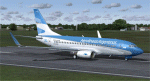
This is a repaint in the "New Livery" of "Aerolinas Argentinas" for the Kitty Hawk 737-700W. This is a complete file and for FS9 (FS2004). While it may work in FSX, installing it in FSX is done at your own risk. All repainted textures have been formatted in 32 bit and have been 100 % hand painted (other than the flag and Argentina Logo). There is ONE problem with this paint that I am aware of. The belly paint concludes at the front edge of the nacelle lines when it should continue through to the wheel wells. For some reason (brain freeze perhaps) I was unable to get the paint work good enough for presentation and decided to stay with what is. I am working on this problem and (if) I can work it out, I will upload the appropriate fix. In line with that - please read the enclosed Read Me file as well. Installation, Distribution and Contact details for me can be found in the enclosed Kitty Hawk TC Read Me file. Sorry for the lack of realism and I hoe this does not stop you from downloading the work as is. Cheers.
| Filename: | Aerolinas_Argentinas_NC_Boeing_737700WL.zip |
| License: | Freeware, limited distribution |
| Added: | 1st March 2012, 16:04:48 |
| Downloads: | 270 |
| Author: | Tony Cannon and Kitty Hawk |
| Size: | 3 MB |
| Category: Flight Simulator 2004 - Scenery | |
| Wekweeti CFJ2 in the Northwest Territories, Canada |
|
Images related to this file:
File Description:
Wekweeti is a small village in the Northwest Territories, around 120 miles north of Yellowknife and 100 east of Gameti, which was recently posted. It has a population of around 125. There is no all-weather road access and the village is reliant upon the airfield for supplies, along with an ice road in the winter months. The area is a complex collection of lakes and small rivers and the airfield is around 3 miles east of the village on a lake shore. The lit gravel runway of 3,400 feet with PAPI at both ends is aligned 307T-127T with T standing for "true" and not the unreliable magnetic heading in the Canadian northern domestic airspace. The airfield is served by Air Tindi from Yellowknife on an almost daily basis, included in the AI here along with some GA and a Thursday delivery by a Buffalo DC3. A note here about my scenery making. There will not be many more to follow this as I am almost at the end of the photos I either took or found for scenery purposes, plus I expect to move on from FS9 at some point during next year.
| Filename: | Wekweeti_CFJ2_in_the_Northwest_Territories_Canada.zip |
| License: | Freeware, limited distribution |
| Added: | 4th January 2020, 18:23:59 |
| Downloads: | 154 |
| Author: | Roger Wensley |
| Size: | 4.39 MB |
| Category: Flight Simulator 2004 - Scenery | |
| Aklavik CYKD in the Northwest Territories, Canada |
|
Images related to this file:
File Description:
Aklavik is a town of 650 or so inhabitants at N68 W135, which means 120 miles inside the Arctic Circle and on the West Channel of the Mackenzie River delta. It is 40 miles west of Inuvik and around 60 miles from where the Mackenzie meets the Beaufort Sea. There is only one airline serving the town on a regular basis and that is North Wright, which is headquartered in Norman Wells and also has a base in Inuvik. Aklavik village does not feature in FS9, so the first thing to do was to add it; not all the smaller streets are in place but it is the right shape and with around the right number of houses. The only building with (partly) correct textures is the school near the airfield. I couldn't begin to model 150+ houses, so think of it as a hand-made auto-generated village. I had to move the airfield over beside the river, so there is a DELETE file and a GRASS file, as well as an AFCAD for AI (the AI will follow later) and a scenery file.
| Filename: | Aklavik_CYKD_in_the_Northwest_Territories_Canada.zip |
| License: | Freeware, limited distribution |
| Added: | 10th October 2010, 03:02:19 |
| Downloads: | 630 |
| Author: | Roger Wensley |
| Size: | 1.91 MB |
| Category: Flight Simulator 2004 - Scenery | |
| Alaska North Slope 10; Kivalina KVL in Alaska |
|
Images related to this file:
File Description:
The town of Barrow is in the far north of Alaska, and these are coastal villages or radar installations to the west, south, and east of Barrow on the North Slope. There will be further additions. Kivalina is a small village (population around 350) midway in the 150 mile gap between Point Hope to the north and Kotzebue to the south. The village is on a spit of land that is growing smaller and smaller with every year of erosion and the rise of sea level. The runway is 3,500 feet of gravel aligned 12-30 to the north of the village on the same spit. It was expected that 2025 would see the end of both village and runway, and possibly also the natural harbour that is the reason for the village's location. The modified width of the spit shown here is halved from the original FS9, and erosion has continued, enough that a sea defence wall has now been built. The AI has a daily flight by an ERA Alaska Cessna 208B, and some GA; read the note about the 208 to be downloaded and/or properly installed.
| Filename: | Alaska_North_Slope_10_Kivalina_KVL_in_Alaska.zip |
| License: | Freeware, limited distribution |
| Added: | 27th July 2016, 21:12:15 |
| Downloads: | 243 |
| Author: | Roger Wensley |
| Size: | 2.87 MB |


© 2001-2026 AVSIM Online
All Rights Reserved
Privacy Policy |