
Where Flight Simulation Enthusiasts Gather from Around the World!
AVSIM Library - Search Results

| Category: Flight Simulator 2004 - Scenery | |
| CYVQ - Norman Wells - Northwest Territories, Canada |

|
Images related to this file:
File Description:
Norman Wells is the last of a series of airfields that are along (or close to) the Mackenzie River and in the Northwest Territories. It is 290 miles southeast of Inuvik and just 40 miles northwest of Tulita. The town growth was accelerated by the discovery of oil in the 1930's and the building of a small refinery in 1937, which is included here; there are now around 840 folks living in the town. The airport is adjacent to the town and has just under 6,000 feet of asphalt runway. North Wright Airways is headquartered there and this is reflected in the AI, which is for all of the newly-posted Mackenzie River postings. There is also helicopter AI, Canadian North, First Air, and there are GA flights. There is a mandatory frequency and the Norman Wells tower is manned 24 hours a day so you will follow atc instructions. In real life the terminal is on two levels; this steep change in terrain level is not possible to achieve in FS9 so although I made it as a two level terminal (ready for the FSX version?) it is here modified into a single level building. There are several "taxiways" which lead to the runway but are without hold short markings. These have been shown but are not included as AI routes. The helicopters presumably hover-taxi to the runway across grass (and snow) in real life; the AI helicopter will taxi on wheels. Note that at mixed-use airports planes and helicopters all follow the same rules of procedure.
| Filename: | CYVQ__Norman_Wells__Northwest_Territories_Canada.zip |
| License: | Freeware, limited distribution |
| Added: | 12th July 2014, 11:22:10 |
| Downloads: | 473 |
| Author: | Roger Wensley |
| Size: | 14.57 MB |
| Category: Flight Simulator X - Utilities | |
| Flight Simulator First Officer V2.2 |
|
Images related to this file:
File Description:
Flight Simulator First Officer is a generic virtual copilot for FSX and FS9. The primary function of FSFO is to assist the Pilot In Command (PIC) to fly the aircraft safely while adhering to Standard Operating Procedures (SOPs). This is accomplished via virtual checklist and sharing of cockpit duties/responsibilities. Specifically, the First Officer reads the following configurable checklist: Before Start, After Start, Before Takeoff, In-Range, After Landing and Shutdown. After reading the checklist items, the Copilot will wait to ensure you (i.e. the pilot) have configured the aircraft correctly before proceeding to the next item. Also, the Virtual copilot is capable of performing the following actions: Call Vspeeds based on your input, Raise the Landing Gear on Takeoff, Retract the Flaps, Manage the taxi/landing lights, Land the Aircraft, Tune the ILS frequencies, Call Climb Power based on your input, Reset Vertical Speed when the Aircraft is within 1000 ft of the programmed altitude, IAS warning (e.g. Aircraft is above 250 IAS while below 10000 ft), GS Warnings (e.g. Aircraft is above 25 knots while taxing), Resets the altimeter to standards when passing TA, Engage Heading Hold on Takeoff, Engage Altitude Hold on Takeoff, Reset Speed on Takeoff, Engage Speed Hold on Takeoff, Engages Rev Thrust on Landing, Ground Proximity Warning System (GPWS) and much more...
View the change log to view what's new with V2.2: http://flightsimaddons.proboards.com/thread/32/change-log-updated-july-2014
This is a complete installer; you DO NOT need FSFO V2.*. If upgrading from 2.*, please read the attached readme.txt file for instructions
| Filename: | Flight_Simulator_First_Officer_V22.zip |
| License: | Freeware, limited distribution |
| Added: | 12th July 2014, 08:19:29 |
| Downloads: | 2,359 |
| Author: | Matthew King |
| Size: | 67.17 MB |
| Category: Flight Simulator 2004 - Scenery | |
| Allakaket 6A8 Runway and Taxiway Lighting in Alaska |
|
Images related to this file:
File Description:
Allakaket is on the Koyukuk River in Alaska, 40 miles southwest of Bettles. This posting adds proper runway and taxiway lighting to the scenery, as shown in the screenshots. There will be lights on top of traffic cones visible during the day, just as there are at Allakaket in real life so that pilots can still see them after a snowfall. At night there will be lit lights that properly illuminate the runway for landing, and at a lower level of brightness the taxiway. Put the bgl's into the existing scenery folder of your Allakaket 6A8 installation and say yes to replace the existing bgl's that have the same names. Add the texture bmp's to the texture folder. That's all, and in fact you could try it without the textures in the Allakaket 6A8 texture folder, but read on. Instal the Library objects once and for all by placing the CONTENTS of the Lighting Library scenery folder in your static objects scenery folder and the CONTENTS of the texture folder in the static objects texture folder (which is how I install scenery objects libraries). Alternatively, put them in the scenery and texture folders of your Add on scenery folder, or even in the main scenery and texture folders. They just have to be in related scenery and texture folders that are always active when FS9 is running. There will be further retro upgrades to other recent scenery that was posted with temporary lighting. Say thank you to Greg Putz for making the lighting.
| Filename: | Allakaket_6A8_Runway_and_Taxiway_Lighting_in_Alask.zip |
| License: | Freeware, limited distribution |
| Added: | 23rd November 2019, 20:30:02 |
| Downloads: | 117 |
| Author: | Roger Wensley |
| Size: | 711.35 KB |
| Category: Flight Simulator 2004 - Miscellaneous Files | |
| The World Tour |
|
Images related to this file:
File Description:
01) https://youtu.be/36ZpHnGq7a4
02) https://youtu.be/vFImsajMgLc
03) https://youtu.be/X_FfupH_-MU
04) https://youtu.be/oU6ypwHF6ik
05) https://youtu.be/qz_-HPTv2oo
06) https://youtu.be/Qnbnwi_UAwk
07) https://youtu.be/qeS94k8_hkE
08) https://youtu.be/Rz93YNRQbvw
09) https://youtu.be/BlisZXwgG3Q
10) https://youtu.be/jwor56LaRb4
11) https://youtu.be/IkbSk6z2bfw
12) https://youtu.be/2u8jqtNQxyM
13) https://youtu.be/8qx8R_zCfQ0
14) https://youtu.be/j5kiDHzTBH8
15) https://youtu.be/6z1mLJ-Ne6M
16) https://youtu.be/6sypz9ljSXQ
17) https://youtu.be/_rw5LwjfsmQ
18) https://youtu.be/cp0kDNPjxLc
19) https://youtu.be/eMB7uzHBgeE
20) https://youtu.be/0ohUqRADcjU
21) https://youtu.be/y2PNB0w9SEE
22) https://youtu.be/YHqzjlB8xoo
23) https://youtu.be/bMpS536hPDc
24) https://youtu.be/edd7OmU1674
25) https://youtu.be/vsnCD_dUbEk
26) https://youtu.be/iGR9LkmZ6iI
27) https://youtu.be/G4MeInVKUII
28) https://youtu.be/5RtNJ5N2OuE
29) https://youtu.be/3Ob42QNz6uk
30) https://youtu.be/bdmgdFnADVQ
31) https://youtu.be/uRxygmvyRS8
32) https://youtu.be/mSH-Hh2ShIw
33) https://youtu.be/1HjKTsvub2Y
34) https://youtu.be/An-MndXznow
35) https://youtu.be/aT-Y69R9XeI
36) https://youtu.be/kXwDY1AiIKM
37) https://youtu.be/7VwxMboQCAI
38) https://youtu.be/yFfNxZdcQ6w
39) https://youtu.be/KyRHD9WWpb4
40) https://youtu.be/0zbj7IsSva8
41) https://youtu.be/Z81ixHuSUJE
42) https://youtu.be/rxS0BsyVy8Q
43) https://youtu.be/-9AeEfNRG9c
44) https://youtu.be/hAq9jOC6wFM
45) https://youtu.be/-HuzxYh2cao
46) https://youtu.be/eCngRAujuB4
47) https://youtu.be/_DL0rOV6li0
48) https://youtu.be/DgM4e_bS0uY
49) https://youtu.be/MD0K_VAGtWA
50) https://youtu.be/x6-rHHgb5As

This is only an Utility, to fly a tour of the world in 50 steps. It was Built for FS9, it has not been tested for other simulators (FSX, etc). For presentation, suggestions and other see enclosed file The World Tour.pdf. Contents: 50 flight plans, with FLT, WX and PLN files for each plan and Krakatoa scenery with a fictional scenery of Krakatoa volcano. Enjoy your flights
| Filename: | The_World_Tour.zip |
| License: | Freeware |
| Added: | 29th November 2016, 15:07:29 |
| Downloads: | 232 |
| Author: | Aldo Della Vedova |
| Size: | 35.66 MB |
| Category: Flight Simulator 2004 - Original Aircraft | |
| Nick's Space Shuttle Landing Challenge FINAL RELEASE |
|
File Description:
Featuring the Space Shuttle Discovery and celebrating NASA's return to space!
This package contains the most up to date version of my Space Shuttle Landing Challenge (v1.2). I am providing it as a FINAL single installation package to eliminate the need for multiple update files. This package includes the Space Shuttle Discovery redesigned using actual NASA-Boeing mechanical/aeronautical engineering data, a panel, sounds and shuttle landing FX. The space shuttle in the sim (like the real shuttle) has the ability to water 'ditch' and belly land in an emergency or if improperly landed on the suspension system. You can select the sensitivity of the main landing gear struts (less crashes) for those who are novice to flying critical tolerances. This package includes a CHALLENGE FLIGHT ADVENTURE PACKAGE and features a reference list of the flights along with approach/landing procedure tips to the kneeboard (F-10) for you to refer to while in flight. The adventure pack will provide a set of 11 challenge flights spanning the globe for the space shuttle re-entry simulation. A Bonus PACK of CrashBar effects including smoke, fire, explosions and other nasty reminders of landing mistakes is included as an optional installation. The original .mdl file is by Matthew Moxon and a modified for FS9 panel byTom Kellner. Model repaint, flight dynamics, air file, sound.cfg, adventure flights and shuttle landing\crash FX by Nick Needham. Includes NASA's description of the entire landing process which you can now experience in Flight Simulator! This package includes an install for FS2002 as well and supersedes all other update packages.
ENJOY! Nick Needham, [email protected]
| Filename: | Nicks_Space_Shuttle_Landing_Challenge_FINAL_RELEAS.zip |
| License: | Freeware, limited distribution |
| Added: | 26th August 2005, 22:25:23 |
| Downloads: | 43,522 |
| Author: | Nick Needham |
| Size: | 27 MB |
| Category: Flight Simulator 2004 - Scenery | |
| Beaver Creek CYXQ in Yukon Territory, Canada |
|
Images related to this file:
File Description:
Beaver Creek is located at mile 1202 of the Alaska Highway, just east of the Alaska/Yukon border. The populaton is around 100 and the main employment is with the Border Agency, the White River First Nation, or with local tourist lodges. The airfield is a mile north of the town and close to the Canadian border post, which is included in the scenery. It was built by Jack Stalberg in the 1960's, and I have no further information beyond the fact that he loved to fly. The airport serves as an "airport of entry", though it is restricted in hours of opening and in the size of aircraft that it can handle; up to a maximum of only 15 seats. The single runway is 3,745 feet long and 100 feet wide, gravel, aligned 13-31 in FS9, lit, and with vasi at both ends. Righthand circuits for runway 13. There is a 340 feet threshold displacement to runway 31, which is of course unmarked on a gravel runway. The terminal building was recently reclad; I don't like it, but they didn't consult me. The ai reflects the sort of traffic the airfield gets; ie brief paperwork stopovers for GA or small charter flights into Canada from Alaska, usually in the mornings.I have adjusted the local scenery terrain levels to remove adjacent hills that I believe do not exist in real life but are part of the Northern Canada terrain mesh that I have installed. If you do not have this mesh you may find that the scenery works fine for you without the API flatten that is included here. The airfield is at 2,129 feet ASL.
| Filename: | Beaver_Creek_CYXQ_in_Yukon_Territory_Canada.zip |
| License: | Freeware, limited distribution |
| Added: | 28th January 2019, 06:19:20 |
| Downloads: | 175 |
| Author: | Roger Wensley |
| Size: | 4.68 MB |
| Category: Flight Simulator 2004 - Scenery | |
| Puntzi Mountain CYPU in British Columbia Canada |
|
Images related to this file:
File Description:
Puntzi Mountain is near a village called Chilanko Forks, approximately midway between Bella Coola and Williams Lake and just north of the Chilcotin to Bella Coola Highway. It is what remains of a military base and which currently shows in FS9 as a town, reduced in my scenery version to what remains after the base was closed and cleared. All that remains of the base is now the runway, over 6,000 feet of asphalt aligned 04-22, unlit, at 2,985 feet above sea level, and with centre line markings that are almost invisible. The runway is used in the summer for whatever local fire-fighting operations are needed by ConAir and there are some buildings and fuel tanks for this. It is also used for local flights such as those for a lodge on Puntzi Lake to the north. I have added three AT-802 textures with additional tail numbers for use in the AI. These are to be added to an aircraft that you very likely already have and which was included in Don Grovestine's posting of Abbotsford CYXX. I have also included the revised config file that adds the planes to Don's original; save the original config under another name and replace it with mine. Put the three new texture folders in with the original, which is called "CYXX-AI_Air Tractor AT-802 (Wheels)". If you do not have Don's scenery I suggest you get it, as his work is worth having and like Greg Putz he puts in a lot more effort than I do. The L188 Electra should already be with you if you downloaded my Smithers CYYD scenery. If you find a defect, email me.
| Filename: | Puntzi_Mountain_CYPU_in_British_Columbia_Canada.zip |
| License: | Freeware, limited distribution |
| Added: | 20th November 2020, 05:33:01 |
| Downloads: | 174 |
| Author: | Roger Wensley |
| Size: | 10.33 MB |
| Category: Flight Simulator 2004 - Original Aircraft | |
| Savoia Marchetti SM.79 Sparviero, SERVICE PACK 1 (v.02) |
|
Images related to this file:
File Description:
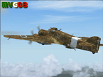
It was the most important Italian bomber of World War II, this tough three-engined aircraft established a reputation that contrasted with most Italian weapons of the day, and it was flown with courage and skill. SM.79s served widely in the normal bombing role, but it is as a land-based torpedo bomber that the type deserves its place in military aviation history, being regarded by many as one of the finest torpedo bombers of the war. In spite of its cumbersome appearance and outdated construction, with an internal provision for 2,750 lb (1,250 kg) of bombs, supplemented by under fuselage rack for a torpedo, the S.M.79 was a rugged, reliable multi-role medium bomber which did quite a bit of damage in the face of heavy opposition. About 1,300 production models were built over a nine year period. The SM.79 had a distinctive 'hump' on the upper forward fuselage, which housed both the fixed forward-firing heavy machine-gun and the dorsal gunner's position. Its appearance earned the aircraft the nickname 'Gobbo Maledetto' ('Damned Hunchback'). During the last phases of the war the surviving SM.79s were converted into various versions of utility transports and used in that role until 1952.
This "Service Pack" contains:
-4 UPGRADED + 1 NEW Hi-Res GMax models (5 different versions) feature the usual moving parts, such as all flight controls, props pitch and leading edge flaps.
-Eleven (11) different liveries (6 R.A., 1 A.N.R., 1 I.C.A.F., 1 Post-war A.M.I., 2 Spanish Nationalist Air Force).
-Revised SM.79M CFG & AIR files, New SM.79Bis CFG & AIR files
-Revised Sounds, Gauges & Effects
VC only. This plane was developed for FS9, but it works (it seems without problems) either in FSX. Created by Manuele Villa & ItalianWings, February 2008. Installation instructions included.
| Filename: | Savoia_Marchetti_SM79_Sparviero_SERVICE_PACK_1_v02.zip |
| License: | Freeware |
| Added: | 31st May 2010, 09:24:20 |
| Downloads: | 3,321 |
| Author: | Manuele Villa, Italianwings |
| Size: | 32.56 MB |
| Category: Flight Simulator 2004 - Scenery | |
| Kuujjuarapik CYGW in northern Quebec, Canada |
|
Images related to this file:
File Description:
Kuujjuarapik is in northern Quebec at the southern end of Hudson Bay, 90 miles east of James Bay and on the north shore of the Great Whale River; Kuujjuarapik means Small Great River in Inuktitut. Once again the Hudson Bay trading post that opened (in 1820) was the catalyst for the establishment of first a seasonal encampment and then the beginnings of a town in the late 1930's.
The two adjacent villages that now form the town have a total population (mainly Cree and Inuit) of around 1,500. When the Quebec hydo-electric project was under construction in the early 1980's a large portion of the Inuit population voted to move to a new settlement called Umiujaq (my post) 100 miles to the north.
The airport is to the west of the town, between the town and the sea. The gravel and sand runway (which I have made as gravel as there is no convincing way to mix the two) is 5,500 feet long, 150 feet wide, and aligned 17/35, which is approximately parallel to the coast. There is fuel available, both 100LL and JetA, delivered by truck. The AI included here is for Air Inuit and Wasaya, with Air Inuit making three flights per day plus a fourth flight by the Air Inuit Twotter C-GNDO that is based at the airport, and private flights by various aircraft. Yes, there really is a golf course to the south of the airport, and the last thing to note is that Kuujjuarapik has a mandatory radio frequency and that taking into consideration the scheduled flights I have included the tower radio frequency that makes this a controlled airport in FS9.
| Filename: | Kuujjuarapik_CYGW_in_northern_Quebec_Canada.zip |
| License: | Freeware, limited distribution |
| Added: | 16th February 2013, 00:33:20 |
| Downloads: | 306 |
| Author: | Roger Wensley |
| Size: | 2.8 MB |
| Category: Flight Simulator 2004 - Scenery | |
| Alaska South Slope 12; Teller K54 |
|
Images related to this file:
File Description:
There are four main northwestern Alaska towns which are serviced by Alaska Airlines, and from which local flights spread out. The northernmost is Barrow. Southwest of Barrow is Kotzebue, then Nome, and the furthest south is Bethel (not yet made). This is the fifth in a series for local flights from Nome, and it is on the coast around 55 miles east of Wales and 55 miles northwest of Nome. There are two other airfields around a large lagoon that is almost totally enclosed from the sea, and Teller is on the easten shore, just 15 miles east of Port Clarence and 5 miles southeast of Brevig Mission, both already posted. Teller has a populaton of around 230, down from the 5,000 or so in the early 1900's after the Bluestone Placer Mine struck gold. Tollef Brevik was a Lutheran missionary who was both a pastor and teacher for the Inuit in the area from 1894 onward, travelling from community to community but based in Teller, where the Teller Mission Church was later renamed the Brevig Mission. The name was later appropriated and used for the curent village of that name; he was surely very well regarded by the local population. Unusually, it is possible to drive from Nome to Teller in summer, on a dirt road. Conversely, the road that shows in FS9 to the north towards Brevig Mission (courtesy of Ultimate Terrain) does not in fact exist except in winter, when it is estabished on the snow by the tyre tracks of users. The airstrip is southeast and 2 miles by road from the main part of the village on the spit, with a gravel runway 02-25 which is 3,500 feet of gravel. The AI is the usual for this area, Bering and ERA with some GA and cargo by Everts.
| Filename: | Alaska_South_Slope_12_Teller_K54.zip |
| License: | Freeware, limited distribution |
| Added: | 25th October 2016, 21:21:14 |
| Downloads: | 235 |
| Author: | Roger Wensley |
| Size: | 2.96 MB |


© 2001-2026 AVSIM Online
All Rights Reserved
Privacy Policy |