
Where Flight Simulation Enthusiasts Gather from Around the World!
AVSIM Library - Search Results

| Category: Flight Simulator 2004 - Scenery | |
| Sydney CYQY in Nova Scotia Canada |

|
Images related to this file:
File Description:
Sydney is a maritime port on the east coast of Canada, on the eastern corner of Cape Breton Island. It was founded in 1785 and grew in size emormously from 1900 as a steel mill was founded that prospered along with local coal mines until 1950 or so. After that date and following the final closure of the mill in 2001 the population declined to the current 29,000 or so. The airport is 3 or 4 miles southwest and inland of a coastal urban area which stretches from New Waterford in the north through Lingan, Dominion, Reserve Mines, and Glace Bay, to Port Caledonia, and 5 miles east of the town of Sydney which is beside a sheltered deep water harbour area. This version is not from a fixed date as although I had video of some of the buildings from 2010 I inadvertently constructed part of the apron layout from 2018 information, and then decided to keep it like that either because I liked it or perhaps was too lazy to redo it. The terminal building and the garages to the east of the terminal are original and old, though renovated and maintained to a fairly good standard. The other buildings on the airport are "hangars" in the expected form, with steel frames, insulated cladding, and pitched roofs. The airport publicises it's ability to cater for all the needs of visiting aircraft, with a large FBO hanger just beside the terminal. There are (or were, before the virus came along) scheduled flights by Westjet, Air Canada Jazz, and Air North, which are included in the AI along with GA flights. The runways are 07-25 at 7,000 feet and with PAPI on 25 and ILS on 07, and 01-19 at 6,000 feet with PAPI on 01 and ILS on 19. You will see once the scenery is installed that there are two folders in Sydney CYQY called "Scenery summer" and "scenery winter". Editing the folder name down from "scenery summer" to just "scenery" results in FS9 loading the summer ground textures and parked planes etc. In February you would edit down the "scenery winter" folder to just "scenery" and the unused and unswept taxiways, runway, and aprons will be invisible under the snow, the open-topped cars will not be parked in the open, and privately-owned planes will be in the hangars. If FS9 decides that there is snow on the ground then you need the winter textures, if not then the summer textures. The winter textures are not the full-snowdrift-middle-of-Winter-gale type and are more like early or late winter. One thing you must NOT DO is to edit both folders down at the same time.
| Filename: | Sydney_CYQY_in_Nova_Scotia_Canada.zip |
| License: | Freeware, limited distribution |
| Added: | 22nd August 2020, 00:07:58 |
| Downloads: | 277 |
| Author: | Roger Wensley |
| Size: | 29.42 MB |
| Category: Flight Simulator 2004 - Scenery | |
| Cyprus: Airfields plus landmarks and land class for all of Cyprus and AI |
|
Images related to this file:
File Description:
Cyprus, an island in the eastern Mediterranean. Without the benefit of Ultimate Terrain, which does not exist for Cyprus, the land class provided by FS9 stands out as hopelessly inadequate. I have added the extensive farmland and the larger towns and villages, plus the major roads. Four completely new airfields are included here, three in the north and one in the south. Ercan LCEN is in the north and functions as the airport for all of the north. It was recently closed for two years while a new terminal was built and the runway updated and an apron extended etc, and during that time Gecitkale LCGK functioned (barely) as the airport for the north. Gecitkale is now hardly used at all. The third northern airfield is Ilker Karter LCIK and this functions as the HQ base of the Turkish Army Corp in northern Cyprus. The last of the new airfields is Kingsfield LCRE, which is in the Sovereign Base area to the east of Larnaca and is now used for recreational purposes. Ercan is now undergoing further expansion with a new runway and a new terminal building and apron, so this scenery is for the period between 2010 to 2015. My set up of Cyprus already included a payware Larnaca by Aerosoft (now only 12 euros) plus a freeware Paphos, Nicosia, and Akrotiri; that was my starting point. Larnaca has been the major airport for Cyprus since the mid 1970's, with a huge tourist trade that peaks in the summer but which is year long (almost a million Brits visit every year, let alone the other nationalities). I have adapted this (gate sizes etc) to allow parking by a multitude of B737's and others. Nicosia is freeware (posted in 2010) and I have included modifications to reflect its now total disuse. Paphos is at the far western end of the island and freeware, and I have modified this to allow larger and military ai aircraft to function properly; the poster improved his first version to better cater for ai but I was unaware of this and I have stayed with my modifications. Akrotiri is freeware and includes a lot of library object input from MAIW. I have modified the parking somewhat and added further residential areas and munitions storage. The AI is based upon recorded take offs and landings in April, with some further additions in later months. At Ercan the visible gate numbers on the apron are as per real life, but the numbers within FS9 reflect the fact that planes are directed to gates at the centre of the terminal building and not at the far ends. Follow the pink line and obey ATC when it says taxi to gate number 2 even if it is visibly numbered 4.
| Filename: | Cyprus_Airfields_plus_landmarks_and_land_class_for.zip |
| License: | Freeware, limited distribution |
| Added: | 13th August 2017, 21:21:46 |
| Downloads: | 945 |
| Author: | Roger Wensley |
| Size: | 29.61 MB |
| Category: Flight Simulator 2004 - Scenery | |
| Mackenzie CYZY in British Columbia, Canada |
|
Images related to this file:
File Description:
Mackenzie is around 120 miles west of Peace River and the BC/Alberta border, at the southern end of Williston Lake. The lake is 135 miles long and the population of the town is about 3,500; those figures illustrate typical Canada, a huge area enjoyed by the few. The main occupations relate to timber and mining in some form, plus tourism (in particular winter sports tourism). The airport is 2 miles southwest of the town, with no regular scheduled flights but it is not unusual to find Central Mountain Air there delivering either charter passengers or freight. The single runway is aligned 16-34 and 100 feet wide lit asphalt that is just over 5,000 feet long, with (in 2010 or so) an additional 1,500 feet of gravel. There is PAPI at both ends of the asphalt. The largest operation based at the airfield is a helicopter company, at the northern end of the apron. There is a "mandatory frequency" of 123.5 which is a Canadian invention; you MUST have a radio. There is no control tower at the actual airfield, and if or when there is no response from further afield then you announce your intentions etc. In FS9 there is no way to "switch off or on" the monitoring of a MF radio frequency so you will find that this one is always silent.
| Filename: | Mackenzie_CYZY_in_British_Columbia_Canada.zip |
| License: | Freeware, limited distribution |
| Added: | 27th December 2018, 20:19:05 |
| Downloads: | 133 |
| Author: | Roger Wensley |
| Size: | 19.81 MB |
| Category: Flight Simulator 2004 - Scenery | |
| Teslin CYZW in the Yukon, Canada |
|
Images related to this file:
File Description:
Teslin is a village on the Alaska Highway around 85 miles east of Whitehorse, on the banks of the very long Teslin Lake and where there is a sizeable bridge across an offshoot of the lake. The Hudson Bay trading company established a post there in 1903. The current population is a rather meagre 120 or so and the only reason I am making this scenery is that I know one of the 120. This scenery, in addition to the terrain, village, bridge, and airport items also modifies the Alaska Highway. The AI includes a school excursion trip on a chartered Air North Hawker Siddeley 748 on Saturday. There are no scheduled flights to the field. The runway is now around 5,600 feet of gravel aligned 08-26 and with VASI at both ends. It is lit with runway lighting on the tops of traffic cones, and you will need to download the lighting library from my earlier postings of either Allakaket Lights or Anaktuvuk Lights earlier this week. A note here about my scenery making. There will not be many more to follow this as I am almost at the end of the photos I either took or found for scenery purposes, plus I expect to move on from FS9 at some point during next year.
| Filename: | Teslin_CYZW_in_the_Yukon_Canada.zip |
| License: | Freeware, limited distribution |
| Added: | 5th December 2019, 18:37:13 |
| Downloads: | 128 |
| Author: | Roger Wensley |
| Size: | 6.87 MB |
| Category: Flight Simulator 2004 - Scenery | |
| Rae Lakes CYRA at Gameti in the Northwest Territories, Canada |
|
Images related to this file:
File Description:
Gameti is a village in the Northwest Territories, around 65 miles north of Whati which was recently posted. Until 2005 the village, which has a population of around 280, was known as Rae Lakes and the airfield is now renamed Gameti/Rae Lakes as shown in the 2010 version of the Nav Canada Flight Supplement, my standard reference year. Permanent settlement was established there in 1965. There is no all-weather road access and the village is reliant upon the airfield for supplies, along with an ice road in the winter months. The airfield is a mile or so east of the village, with a lit gravel runway of just over 3,000 feet aligned 14-32 and with PAPI at both ends. The airfield is served by Air Tindi from Yellowknife on an almost daily basis, included in the AI here along with some GA and a Friday delivery by a Buffalo DC3 that uses all of the runway. The runway has lake water at each end, ready for the unwary. A note here about my scenery making. There will not be many more to follow this as I am almost at the end of the photos I either took or found for scenery purposes, plus I expect to move on from FS9 at some point during next year.
| Filename: | Rae_Lakes_CYRA_at_Gameti_in_the_Northwest_Territor.zip |
| License: | Freeware, limited distribution |
| Added: | 26th December 2019, 19:32:09 |
| Downloads: | 124 |
| Author: | Roger Wensley |
| Size: | 4.81 MB |
| Category: Flight Simulator 2004 - Aircraft Repaints, Textures and Modifications | |
| Eastern Air Lines, Douglas DC-7B (N836D) |
|
Images related to this file:
File Description:
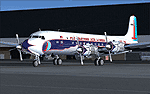
Eastern Air Lines, Douglas DC-7B (N836D) livery for FS9/FSX - This aircraft in real life has been lovingly restored by the Historical Flight Foundation (HFF). It has recently been approved for flight by the FAA, and should be seen at airshows soon.
The HFF is unique in that its Douglas Aircraft Co. DC-7B aircraft represents the only U.S. based, four engine, passenger prop-liner in operation today. The aircraft being operated by the HFF was still in its original passenger configuration as delivered to Eastern Air Lines in January 1958. Of the 112 DC-7 aircraft produced, this is the only surviving passenger configuration aircraft. You can read more about this aircraft and get all the latest news at: http://www.n836d.com/
THIS FLIGHT SIMULATOR VERSION:
This livery is a re-creation of the aircraft restored by the HFF, and is accurate as of April 2010. It uses a special model created by Tom Gibson, to allow an accurate livery layout on the nose and nose gear doors. Please follow the installation instructions carefully. You'll need to download and install the CalClassic Domestic DC-7B - the American Airlines DC-7B Base Pack: www.calclassic.com/dc7b.htm
For details about the FS plane, please refer to the DC7B2K4.TXT file in the Domestic DC-7B zip file.
| Filename: | Eastern_Air_Lines_Douglas_DC7B_N836D.zip |
| License: | Freeware |
| Added: | 29th April 2010, 09:47:43 |
| Downloads: | 1,038 |
| Author: | Eric Joiner, Tom Gibson, Greg Pepper, Jens Kristensen |
| Size: | 8.46 MB |
| Category: Flight Simulator 2004 - AI Flight Plans | |
| Chilean Transports and Tankers Complete AI Package |
|
Images related to this file:
File Description:

The members of Military AI Works are proud to bring you this freeware AI package, produced by Mike Guenthner in conjunction with Military AI Works and adds the three recently acquired KC-135E aircraft of the Chilean Air Force (FACh) as well as their C-130B aircraft to your FS9 skies.
This package is the first release of the MGAI KC-135E model which is based on the original MAIW KC-135R AI model and shares the same animations and features as its newer cousin. The Henry Tomkiewicz C-130 AI models round out the included military aircraft in this package.
These three Hercules AI aircraft were originally released in 2007 as part of the "MAIW Exotic Alberts" package. If you have previously installed the "Exotic Alberts Chile" package, you should remove all contents from that package prior to installing this package. We have updated the textures for these C-130B aircraft as well as made some other minor changes to them which reflect the changes that have occurred since 2007.
Credits:
Models by Mike Guenthner and Henry Tomkiewicz;
FDE/Effect by Mike MacIntyre and Henry Tomkiewicz;
Repaints by Graham King and Mark Walsh;
Flightplans by Desmond Burrell and Barry Taylor;
VCPs by Stewart Pearson;
Scenery Libraries and Placement by John Stinstrom and Mark Campbell
| Filename: | Chilean_Transports_and_Tankers_Complete_AI_Package.zip |
| License: | Freeware |
| Added: | 9th December 2012, 19:20:59 |
| Downloads: | 662 |
| Author: | Mike Guenthner, Military AI Works (MAIW) |
| Size: | 7.87 MB |
| Category: Flight Simulator 2004 - Scenery | |
| Mustique TVSM in the Grenadines |
|
Images related to this file:
File Description:
Mustique island is one of the northernmost of the group of islands known as the Grenadines, just south of Bequia. Mustique is a small island, less than 3 miles long and even at its widest less than a mile wide; as a result the resident population is less than 500. The island is unique in that it is owned by a company. The company is owned, in its turn, by the owners of the 100 or so private villas on the island. The Queen of England is one owner; her participation is balanced out by Jeremy Clarkson.
The airport is at the northern end of the island; the runway is around 3,240 feet long, aligned 09 (and with the southeast trade winds it is most unlikely that you will ever find yourself using 27) and with a steep and displaced threshold of over 900 feet. The displaced threshold is shown but unfortunately FS9 is not capable of coping with anything other than a prefectly flat airport. The terminal is a steel-framed shed with cladding, but is "quaintly" transformed with a palm frond roof etc. There are connecting flights by SVG to Barbados and the other islands and these are reflected in the AI. The airport has no lighting, and flights are obliged to land and depart in daylight hours only, outside of which the airport is closed.
| Filename: | Mustique_TVSM_in_the_Grenadines.zip |
| License: | Freeware, limited distribution |
| Added: | 11th June 2013, 22:57:37 |
| Downloads: | 512 |
| Author: | Roger Wensley |
| Size: | 2.07 MB |
| Category: Flight Simulator 2004 - Scenery | |
| PASN St Paul Island in Alaska |
|
Images related to this file:
File Description:
This is St Paul Island airport, plus the town and the harbour which has featured alongside Dutch Harbor in the tv series Deadliest Catch.
St Paul is in the Pribilof group of five islands around 250 miles north of Dutch Harbour. The town has a population of less than 600, so a lot smaller than Dutch Harbour and with only one processing plant, Trident.
The Ai includes a PenAir flight, a Coast Guard C-130, and Coast Guard helicopters; sea AI includes a fishing boat and a Coast Guard cutter. The Coast Guard C-130 and helicopter flights are to Dutch Harbor, so both sceneries are required to make it work as it should. The airport has 6,500 feet of 150 feet wide asphalt with 1,000 feet of over-run at each end, aligned 36/18, lit, and with two aprons at the southern end. There is no hangerage except for Coast Guard helicopters. Runway 36 has at its northern end a hill.
In real life the runway slopes up to the north by over 60 feet, but in FS9 it doesn't; hence the change in airport elevation to 80 feet ASL to get the northern end at least partly out of a box canyon. There is fuel available and it is dispensed from a truck, there are no pumps.
| Filename: | PASN_St_Paul_Island_in_Alaska.zip |
| License: | Freeware, limited distribution |
| Added: | 12th August 2012, 17:39:02 |
| Downloads: | 1,100 |
| Author: | Roger Wensley, Sidney Schwartz |
| Size: | 4.06 MB |
| Category: Flight Simulator 2004 - Scenery | |
| Ontario Small Fields in Canada: #05 Pelee Island (CYPT) |
|
Images related to this file:
File Description:
This is the fifth in a series of small airfields in southern Ontario Canada, Pelee Island CYPT, an airfield on the island in Lake Erie and the southernmost airfield in Canada. The airfield has an asphalt runway of 3,300 feet, aligned 09/27 in FS9 while today in real life it is 10/28 due to the wandering magnetic pole. There is also a second runway, 36/18 and around 1,500 feet of gravel. There is a small terminal building which now has blue cladding; here it is still in the dirty yellow of the original colour scheme.
This version is based upon what appears to be a "lost" 2005 scenery of Pelee Island. When I started to make Pelee Island I discovered that in fact I already had a version installed; my memory can be excused, as I installed it in 2005. I modified the scenery to include parking, taxiways that connected, revised runway markings, new windsocks, new signage, larger apron, parked cars and planes, revised landclass, AI, etc. My intention was to instruct you to download and install the original and then incorporate my changes. Problem: it does not appear to exist for download; perhaps it was washed away when the Avsim site crashed. I have included it in this post. If anyone knows who made it please let me know.
| Filename: | Ontario_Small_Fields_in_Canada_05_Pelee_Island_CYP.zip |
| License: | Freeware, limited distribution |
| Added: | 5th August 2015, 18:52:25 |
| Downloads: | 171 |
| Author: | Roger Wensley |
| Size: | 4.39 MB |


© 2001-2026 AVSIM Online
All Rights Reserved
Privacy Policy |