
Where Flight Simulation Enthusiasts Gather from Around the World!
AVSIM Library - Search Results

| Category: Flight Simulator 2004 - Scenery | |
| Kerkira Airport Enhancement |

|
File Description:
This is old scenery which has been updated for FS2004 and enhances the visual environment of Ionian sea island airport of Kerkira, also known as Corfu. Its part of my “Greek Airfields” package that currently is not fully compatible with FS2004 since MS decided to move the airports in Greece and elsewhere to adjacent positions and ASD, which I use for placing these objects, is not compatible with FS2004. Here you will find airport & terrain enhancements for Hellenic airport of Kerkira LGKR that make it look closer to the real one; hotels, runway turning bay, perimeter fences, windsocks, radio antennae, new approach radar antenna to the southwest and most importantly, an exclusion of autogen scenery that is wrongfully generated on each side of the runway. A big difference is attributed to Babis Peribolas’s Kerkira mesh terrain that is included in this scenery. Scenery includes the necessary ASD 2.1 textures.
| Filename: | Kerkira_Airport_Enhancement.zip |
| License: | Freeware, limited distribution |
| Added: | 4th September 2003, 02:23:06 |
| Downloads: | 12,173 |
| Author: | Kyprianos Biris |
| Size: | 1.94 MB |
| Category: Civil Flight Simulators - Looking Glass Flight Unlimited 3 | |
| Flight Unlimited III Seattle Region expansion up to Vancouver |
|
Images related to this file:
File Description:
With this zip you get the opportunity to expand the Seattle region of your FU3 flight simulator up to Vancouver. The original region has 100 tiles (10x10) and the new region will hold 180 textured tiles (10x18). After all installation steps are done you will have a low resolution area from Coupeville Nolf up to Vancouver, but still better than OT texture. Everyone who's interested can obtain this set of megatiles with proper elevation and a basic scenery layout each one may take this to a more refined level later. Whether one elects to keep the basic textures or replace them with good orthophotos the terrain is there and new airports can be shared and used by everyone with an expanded high-res region. You will need 6 other files from the AVSIM library to prepare your game for this expansion, see readme file inside workfolder.
| Filename: | Flight_Unlimited_III_Seattle_Region_expansion_up_t.zip |
| License: | Freeware, limited distribution |
| Added: | 27th January 2011, 22:00:03 |
| Downloads: | 162 |
| Author: | Andre Meystre |
| Size: | 95.9 MB |
| Category: Flight Simulator 2004 - Utilities | |
| Courseplanner 3.D.3, Flight Planner |
|
File Description:
FS2004/FSCOF/FS2002/FS2000 Courseplanner 3.D.3, stand alone flight planner.
Complete flight management on a realistic world map. Over +30000 SID/STAR as well as +60000 waypoints.
Use YOUR own scenery, (airports, Navaids, etc), and all the planes in your hangar.
Monitor your progress, all the AI traffics, (and multiplayer), real time on the internet and intranet, this includes altitude, speed and more.
Great to use when flying with VATSIM or IVAO.
Use Courseplanner over the network, (CP on one machine and FS on another), or both on the same machine.
Runs independently to FS, (you do not even need to have FS running).
Import/Export FS flight plans and/or adventures.
Create printable maps, (en route, departure, airport, ILS etc), as well as the briefing files.
Courseplanner will fly the aircraft for you and even 'pause' the flight near the airport, or any point for that matter.
| Filename: | Courseplanner_3D3_Flight_Planner.zip |
| License: | Shareware, time limited |
| Added: | 23rd December 2005, 12:45:50 |
| Downloads: | 8,062 |
| Author: | MyOddweb.com Team |
| Size: | 26.35 MB |
| Category: Flight Simulator 2002 - Utilities | |
| Weather Center 2.1 Novice Edition |
|
File Description:
Weather Center 2.1 is an advanced weather generation add-on module for Microsoft Flight Simulator 2000/2002. Weather Center 2.1 features a completely re-engineered weather generation core that produces some of the most realistic, generated weather environments ever seen in Flight Simulator! The new, unique "I-Field" algorithm translates automatically downloaded Internet data into a dynamic weather environment based not only on the data from the nearest reporting airport (like Weather Center 1), but on all nearby airports, which all provide some piece of the overall weather scene generated around the aircraft! The Novice edition includes a 15-minute demo period each time it is started, during which all the Expert features are enabled. After the demo period expires, there is no requirement to upgrade to the Expert edition; however, the Novice edition continues to function indefinitely with a simpler weather generation algorithm with most new core features disabled.
| Filename: | Weather_Center_21_Novice_Edition.zip |
| License: | Freeware |
| Added: | 6th June 2003, 19:36:17 |
| Downloads: | 1,777 |
| Author: | Keith Kile |
| Size: | 5.83 MB |
| Category: Flight Simulator 2004 - AI Flight Plans | |
| SATSair Complete Package Summer 2008 |
|
File Description:
This package includes representative flightplans for SATSair (Smart Air Travel Systems) drawn from flightaware and a texture for Mike Cronin's AI SR22 (available on AVSIM). SATSair is an air taxi system in the southeast US using 22 Cirrus SR-22s for on demand air travel.
From their website: "SATSair offers regional point-to-point air transportation that is safe, convenient and cost effective. Aircraft are pre-positioned strategically throughout the service area, allowing customers to board a SATSair aircraft and depart with little notice. SATSair eliminates the frustrations of crowded airline terminals, long security lines and lengthy connections. In addition, SATSair utilizes numerous airports that the airlines don't, making it exceptionally convenient for rural destinations and multiple-stop itineraries."
These plans may be installed using MRAI setup, or manually using Lee Swordy's TTools. As part of my continuing effort to expand the AI world, here you go!
| Filename: | SATSair_Complete_Package_Summer_2008.zip |
| License: | Freeware |
| Added: | 24th July 2008, 21:41:10 |
| Downloads: | 449 |
| Author: | David Nelson |
| Size: | 70.58 KB |
| Category: Flight Simulator 2004 - Gauges | |
| Airport ID Gauge |
|
Images related to this file:
File Description:
Do you ever wonder what airports you are flying over and do not wish to consult a Map or the GPS (if your aircraft has one)?
This little gauge, which can be easily added to virtually any panel, will display the ICAO code, the Airport Name and the Airport's location as you pass nearby. The display can be fixed on a panel or can be installed as a pop-up window called by a panel icon. Complete instructions and sample setups using the default Cessna 172 are included. This gauge is designed to be used in the 2D cockpit environment has been tested in FS2004 but may work in FSX also. XML script by the late Roelof Kruijer - packaged by David "Opa" Marshall for your flying enjoyment. Please unzip to a temporary folder and follow the instructions which are in .Doc and .PDF formats.
| Filename: | Airport_ID_Gauge.zip |
| License: | Freeware |
| Added: | 2nd February 2011, 01:53:40 |
| Downloads: | 2,074 |
| Author: | Roelof Kruijer and David "Opa" Marshall |
| Size: | 400.69 KB |
| Category: Flight Simulator X - Panels | |
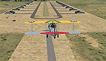
| FSX Alpha F-111 Aardvark HUD Navigation/Situation awareness panels |
|
Images related to this file:
File Description:
FSX Alphasim F-111 Aardvark HUD Navigation/Situation awareness cockpit
with massive amount of digital data. Must have ALPHASIM F-111 Aardvark to
build up this complete and separate F-111. Exceptional capability cockpit
Comprising: Pilot, WSO and virtual panels.3 MFD with 19 selectable pages
of data. 3 GPS type moving maps. 16 Nearest airports page with full City
names and ICAO entry capable displays in HUD. autopilot. autothrottle
and TFR. Enhanced HUD is selectable in all views including 10 camera
views. All data clearly readable size. Aircraft carrier capable.
Effects: bombs. missiles. flares. dump and burn. exhaust trail.
Detailed 40 pge Flight Manual plus docs folder.Configuration ensures
crisp and extremely precise controlled flight even down to 10 ft AGL.
This panel will set a new benchmark of the amount and type of data
provided and its presentation. Possibly the best pilots aircraft ever.
By Karol Chlebowski.
| Filename: | FSX_Alpha_F111_Aardvark_HUD__NavigationSituation_a.zip |
| License: | Check within download |
| Added: | 29th November 2009, 15:56:47 |
| Downloads: | 412 |
| Author: | Karol Chlebowski |
| Size: | 24.72 MB |
| Category: Flight Simulator 2004 - Miscellaneous Files | |
| Active ILS - KIAH (G Bush Intercontinental/Houston Airport) |
|
File Description:
As most know initiating the ILS at certain airports for AI Traffic is not a function at this time when using AFCAD2. If you add a new ILS runway to an airport such as KIAH (G Bush Intercontinental/Houston Airport 8L/26R) only the user aircraft can use this runway when visibility falls below 3 miles. ATC will no longer use this runway for AI Traffic because FS9 sees it as a visual runway and will now vector your AI Traffic back to 8R/26L which is also a Terminal departure runway. This file adds all NAVAIDS for making 8L/26R a Precision Instrument Runway by adding all the radar fixes for both the ILS approach portion and the proper missed approach procedures, altitudes and intersections as per current published plates. All AI Aircraft will now continue to use 8L/26R when Airport conditions are less than 3 miles.
| Filename: | Active__ILS__KIAH_G_Bush_IntercontinentalHouston_Airport.zip |
| License: | Freeware, limited distribution |
| Added: | 19th June 2004, 07:15:30 |
| Downloads: | 2,031 |
| Author: | Jim Vile |
| Size: | 41.99 KB |
| Category: Flight Simulator 2004 - Scenery | |
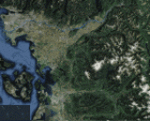
| IONE, Washington - S23 - Airport and adjacent scenery |
|
Images related to this file:
File Description:
Ione is a small airport close to the Washington-Canadian border, about 60 nm North of KSFF (Felts). The ICAO code S23. It now has NDB and VOR; frequencies for these are NDB- 379, VOR-113.20. This airport is an enhanced version of the default S23. It handles small AC only. This is for FS9.
This project started out as an enhancement for my ski-patrol bro who lives in Ione and grew into a major project. This project has four, basic major parts -
1. the airport itself.
2. back road area with a few farm houses, gas station and church.
3. small town - courtesy of Opa Marshall who spent much time with me on suggestions and guidance.
4. Camp ground area.
We hope you will enjoy this work. Readme file has contact info and airport ID of some close by airports. Bob
| Filename: | IONE_Washington__S23__Airport_and_adjacent_scenery.zip |
| License: | Freeware |
| Added: | 2nd February 2010, 10:19:49 |
| Downloads: | 1,332 |
| Author: | Robert Lacy & David "Opa" Marshall |
| Size: | 2.06 MB |
| Category: Flight Simulator X - Scenery | |
| FA44 - Willis / Boynton Beach - Miami, Florida - USA |
|
Images related to this file:
File Description:
Neighbor to my 'Antiquers Aerodrome' here at avsim, Willis is another small grass strip just North of Antiquers Aerodrome in the Miami/Ft. Lauderdale area.
I gave it a light touch-up, changed concrete taxiways to oil-treated, added an avgas station, lit the runway, fenced it, an added a small parking lot.
This is a bee-utiful area to fly around in with many many airports. Some are nothing more than a a unmarked no bldg. grass strip all the way up to Miami International. Bahamas a short hop to the East, and Key West to the south. Best observed low & slow in an 'ol tail-dragger.
Three freeware beauties are included to get you started: A.F. Scrub's Fairey Fantome, Yak air7, and P. Clawson's Stinson Voyager.
They are written into the Traffic file along with the retro-paints MS Piper Cub and Mooney Bravo.
| Filename: | FA44__Willis__Boynton_Beach__Miami_Florida__USA.zip |
| License: | Freeware, limited distribution |
| Added: | 18th November 2014, 15:01:10 |
| Downloads: | 466 |
| Author: | Jeff Reed |
| Size: | 16.46 MB |
© 2001-2026 AVSIM Online
All Rights Reserved
Privacy Policy |