
Where Flight Simulation Enthusiasts Gather from Around the World!
AVSIM Library - Search Results

| Category: Flight Simulator 2004 - Aircraft Repaints, Textures and Modifications | |
| "US Package" de Havilland DH-106 Comet 4C |

|
Images related to this file:
File Description:
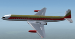
Two textures for David Maltbys DH-106 Comet 4C.
You need to download and install the latest version of the model fom his website www.dmflightsim.co.uk.
These textures in this package depict the only two Comet 4C in The USA. Westernair of Albuquerque acquired three Comet 4C from Mexicana in 1973. Two of them were refurbished and repainted and hoped to sell them complete to an airline. The third aircraft was never made flyable and remained in Mexico.
C/n 06424 (ex XA-NAR) became N888WA and purchased 1978 by Redmond Air, which intended to use the plane for charter flights from Washington State to Las Vegas. The Comet was delivered to Everett. But the plans came to nothing and the aircraft remains at Everett, preserved today for the Seattle Museum of Flight.
C/n 06425 (ex XA-NAS) became N999WA and purchased 1976 by Dick Drost for his "Naked City Nudist Colony" in Indiana. The Comet was flown from storage in Albuquerque to Chicago O'Hare. But never used by the Colony, it was scrapped in 1993 in Chicago.
Despite both Comets had not a flying career in the US, we have the chance to fly them in the Simulator now.
| Filename: | US_Package_de_Havilland_DH106_Comet_4C.zip |
| License: | Freeware |
| Added: | 10th March 2015, 00:02:12 |
| Downloads: | 159 |
| Author: | Manfred Meyer |
| Size: | 2.38 MB |
| Category: Flight Simulator 2004 - Aircraft Repaints, Textures and Modifications | |
| Aerochago S.A. Lockheed C-121C |
|
Images related to this file:
File Description:

Textures for Lockheed C-121C by Team 1049 - Roland Berger, Volker Boehme, Manfred Jahn, Luis Pallas, Bill Tyne and Stefan Werner. Repainted by Manfred Meyer.
A working installation of the G and H Super Constellation packs (L1049H.ZIP, L1049GZIP and r7v-1.ZIP)is required, use the 1049vc_rf model for this textures!
This aircraft (c/n 4202) was built 1956 as 54-0183 for the USAF and served with the MATS Atlantic Div. as "City of Manchester". After retire in 1977 it eas stored at Davis Monthan until 1983 were the Connie was bought by Hangar 10 Inc. and reg. as N515AC. In 1984 she was leased to Air Cargo Intl. Aerochago S.A., Dominican Republic bought the aircraft in September 1988 and used it mainly on freight flights from Santo Domingo or Santiago in Dom. Rep. to Borinqen or San Juan in Puerto Rico and Miami FL. 1992 after the FAA banned Dominican propliners to fly into US airspace, the Connie was stored at Santo Domingo. Hurrican "George" 1988 blew a C-46 (HI-503CT) into it and caused severly damage. After scrapping in 1999 the bow section was shipped to Switzerland and used to built a simulator for Swiss Constellation Flyer Association, SCFA.
| Filename: | Aerochago_SA_Lockheed_C121C.zip |
| License: | Freeware |
| Added: | 21st November 2014, 17:53:46 |
| Downloads: | 223 |
| Author: | Manfred Meyer |
| Size: | 3.64 MB |
| Category: Flight Simulator 2004 - Scenery | |
| Arctic Runway Signs in the "Northern Domestic Airspace", Canada |
|
Images related to this file:
File Description:
These are scenery bgl's to replace those previously posted for Cape Dorset, Gjoa Haven, Igloolik, and Whale Cove. All of these airfields are within what is marked on the chart as "Northern Domestic Airspace" and their runway signage is not given as a magnetic bearing but as a true bearing. This is because at those latitudes, close to magnetic north, the magnetic field is more vertical than horizontal and magnetic readings become unreliable. Planes report their course as a true course, and fly at a height that reflects their true course instead of their magnetic course. The picture shows the runway sign for Qikiqtarjuaq CYVM (which used to be called Broughton Island) which I am working on right now, and I realised that my training was so far behind me that I had forgotten all of the above. The boundary line of the two air spaces is not a straight line; the furthest south it reaches is on the west coast of Hudson Bay just north of Churchill. To the east it passes through the southern end of Baffin Island, and to the west it is north of the coast at the Alaskan border, and there is an illustration included here.
| Filename: | Arctic_Runway_Signs_in_the_Northern_Domestic_Airsp.zip |
| License: | Freeware, limited distribution |
| Added: | 11th June 2011, 03:06:36 |
| Downloads: | 308 |
| Author: | Roger Wensley |
| Size: | 1.21 MB |
| Category: Flight Simulator 2004 - Scenery | |
| Trail CAD4 in British Columbia, Canada |
|
Images related to this file:
File Description:
Trail is in the valley carved out by the Columbia River, around 7 miles north of the Canada-US border and on both banks of the river. The town has a population of just under 8,000 and the main industry is mining. The airport is around 3 miles south-east of the town and on the east bank, with the runway parallel to the river and aligned 16-34, 75 feet wide and asphalt. There are currently no runway or taxiway lights, though there is an overall improvement programme in place to cope with increasing passenger demand. A new terminal building was recently completed, along with alterations to road access and parking; as I have no information regarding these road changes I have left the original "terminal" building in place and in use by Pacific Coastal, the only airline to fly to Trail. There is a Youtube video which gives a very good idea of the basic facilities, and of the surrounding hilly terrain which is similar to that at Bella Cooola at the far side of Pacific Coastal's coverage area. The original position of the airport in FS9 before I corrected it was best described as "in a hole". The hole remains nearby as there is no easy way to deal with it.
| Filename: | Trail_CAD4_in_British_Columbia_Canada.zip |
| License: | Freeware, limited distribution |
| Added: | 23rd December 2018, 17:27:38 |
| Downloads: | 140 |
| Author: | Roger Wensley |
| Size: | 12.3 MB |
| Category: Flight Simulator 2004 - Aircraft Repaints, Textures and Modifications | |
| Italian Air Force, Lockeed F-104G "Starfighter" |
|
Images related to this file:
File Description:
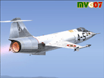
Lockheed's F-104 "Starfighter" was sleek, sexy, and difficult to fly. Essentially a J-79 turbojet with tiny wings and a place for the pilot to sit, it had a poor turning radius and very unpredictable behavior at high angles of attack along with very high takeoff and landing speeds. Its strength was never in its agility, but rather in its speed. The type was the only aircraft in existence at the time that could sustain speeds of over Mach 2.0, and it had a stellar rate of climb.
The "Starfighter" was an icon among jet interceptors throughout the 1970s. It was built also in Italy (G version), under licence. The first Italian F-104G flown during the end of 1962 and the last one (S version) was retired from active service in 2004 (42 Years !!!).
Textures only for two "Starfighters" of the 9 Gruppo of 4 Aerobrigata of the Aeronautica Militare Italiana (Italian Air Force), the first unit to receive the "Starfighter", based on Grosseto Airport, Italy, 1963/64. These textures require a legal copy of the payware Alphasim F-104G. The paints were done with the paintkit provided by Alphasim/Frank Safranek and the metal base textures provided by Henry William. Repaint by Manuele Villa.
| Filename: | Italian_Air_Force_Lockeed_F104G_Starfighter.zip |
| License: | Freeware |
| Added: | 4th June 2010, 11:28:46 |
| Downloads: | 599 |
| Author: | Manuele Villa |
| Size: | 6.05 MB |
| Category: Flight Simulator 2004 - Scenery | |
| CYHD - Dryden Regional - Ontario, Canada * Updated v2 * |
|
Images related to this file:
File Description:
This greatly modifies my previous (2009) post of Dryden; this version has bespoke buildings and is stand-alone and does not require you to have the previous post. There will also be follow-up posts of Sioux Lookout and Geraldton. Dryden is in northern Ontario, 110 miles east of the Manitoba border, 40 miles west of Sioux Lookout, and with the US border 90 miles to the south. The town is on the northern shore of Wabigoon Lake and has a population of around 7,800. The main business is pulp and paper, along with agriculture, tourism, and mining. The airport is 5 miles northeast of the town.
Dryden Regional has 6,000' of asphalt which in FS9 is aligned 11-29. The second runway is compacted sand 2,000' long and aligned 05-23. There are two aprons, the western being for the terminal building and some ga parking, and the eastern larger and used in the summer for parking fire fighting planes, along with maintenance hangarage and accomodation etc. The Ontario Fire Service planes were included with my original Geraldton post and are included here again; they fly back and forth and keep Dryden busy along with several Bearskin Airlines and Perimeter Aviation flights.
| Filename: | CYHD__Dryden_Regional__Ontario_Canada___Updated_v2.zip |
| License: | Freeware, limited distribution |
| Added: | 16th March 2013, 09:59:52 |
| Downloads: | 594 |
| Author: | Roger Wensley |
| Size: | 26.99 MB |
| Category: Flight Simulator X - AI Flight Plans | |
| Joon AI Flight Plans |
|
Images related to this file:
File Description:
Air France's new airline Joon flightplans - 100% flights accurate on the 26/03/2018.
The airline was launched on the 1st of december of 2017, based in Paris Charles de Gaule airport. It is now operating routes to the following destinations:
-Cairo
-Berlin
-Naples
-Rome
-Oslo
-Lisbon
-Porto
-Barcelona
-Istanbul
-Cape Town
The airline is now using 7 A320s, 5 A321s, and 2 A340s, all transfered from Air France.
The airline operated its operation on the 1st of december 2017 as a new subsidairy of AirFrance. All of the aircrafts are all former Air France, i.e. 3 days ago Joon received its first A321 from parent company. Joon seems to follow an hybrid airline with many goals: 1) be cheaper than air france to compete with growing low cost, 2) feed the air france hubs 3) as it is cheaper, fly on destinations where air france is not profitable - or else open new routes 4) try to sound attractive to the younger generations. For all these reasons, Joon is currently flying to Barcelona (lots competition on that route), Rome, Fortaleza (new route) or Mumbai (not profitable neither), have wifi on board and its staff wears hypster clothes ;)The enabler ia the staff having lower wages.
| Filename: | Joon_AI_Flight_Plans.zip |
| License: | Freeware |
| Added: | 27th March 2018, 17:16:41 |
| Downloads: | 544 |
| Author: | chris buty |
| Size: | 69.21 KB |
| Category: Flight Simulator 2004 - Scenery | |
| Dawson Creek CYDQ in British Columbia, Canada |
|
Images related to this file:
File Description:
Dawson Creek is at 2,148 feet asl just east of the Rocky Mountains, less than 10 miles west of the BC/Alberta border. The Peace River, 25 miles north of Dawson Creek, links the two sides of the Rockies, winding through peaks that reach up almost to 8,000 feet. The population grew when the Northern Alberta Railway was extended to Dawsons Creek in 1932, and grew even more more when the Alaska Highway was built in 1942 and Dawsons Creek was where it started from. The airport is just to the east of the town. The runway is 5,000 feet of wide asphalt (150 feet) aligned 06/24, lit, and with PAPI and approach lights. There is a water runway to the north of the main runway with the same alignment, separately designated as Dawson Creek CBD3. The two operate as one; traffic for both use the mandatory frequency of 122.2 and talk to one controller in one control tower. However, in FS9 the ATC for two separately designated airfields operates as if they are nowhere near each other and near misses are the result. I have put them both in un-manned tower mode so you will announce your position and intentions and select your own parking spots etc. There is in reality a lack of apron markings but I have marked the positions of both gates. The apron is not large so there is only one other apron parking spot (see the traffic cone) and most parking is either next to one of the hangars or on the grass. The aprons vary from asphalt, to concrete, onwards to gravel, and then further onwards to some gravel amid the bare dirt; I have replicated this variation as far as FS9 permits. The buildings are bespoke from photos. The AI includes Central Mountain Air with two daily scheduled flights and Northern Cariboo as one of the airlines that occasionally runs charter flights in CYDQ. There are also private GA flights, and float plane flights into and out of CBD3.
| Filename: | Dawson_Creek_CYDQ_in_British_Columbia_Canada.zip |
| License: | Freeware, limited distribution |
| Added: | 22nd November 2013, 23:31:40 |
| Downloads: | 653 |
| Author: | Roger Wensley |
| Size: | 16.65 MB |
| Category: Flight Simulator X - Miscellaneous Files | |
| Fireworks for Deepawali |
|
Images related to this file:
File Description:
Deepawali, also known as Diwali is one of the Major Festival celebrated in India from Jammu Kashmir to Kanyakumari. Deepawali or Diwali is certainly the biggest and the brightest of all festivals. It's the festival of lights (deep = light and avali = a row i.e., a row of lights) that's marked by four days of celebration, which literally illumines the country with its brilliance, and dazzles all with its joy. From darkness unto light the light that empowers us to commit ourselves to good deeds, that which brings us closer to divinity. During Diwali, lights illuminate every corner of India and the scent of incense sticks hangs in the air, mingled with the sounds of fire-crackers, Fireworks, joy, togetherness. On third day of the festival from evening to midnight the entire sky of India is full of colorful fireworks. Its the most awesome night of the year to witness. Every single family in India celebrates Diwali with lights, fire-crackers and fire works.
Lets celebrate Diwali in the virtual world of Flight Simulator. Fly in or out of any airport in India and enjoy your departure or approach phase with great show of fireworks all over the country. Fireworks for both FS2004 & FSX SP2 / Acceleration pack. Tested in FS2004 and FSX Acceleration pack only because its what I have. Enjoy!
| Filename: | Fireworks_for_Deepawali.zip |
| License: | Freeware |
| Added: | 15th October 2014, 00:10:49 |
| Downloads: | 221 |
| Author: | Ashish SIngh |
| Size: | 174.33 KB |
| Category: Prepar3D V1-4 - Aircraft Repaints, Textures and Modifications | |
| North American P-51D 352nd FG (PE-X) "Straw Boss 2" |
|
Images related to this file:
File Description:
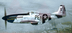
This folder contains a repaint for the A2A WoP3 P-51D Mustang, in the colors of #44-14111 PE-X "StrawBoss 2", which was flown by Col. James D Mayden of the 328 Fighter Squadron/352nd FG. Born in 1912, Mayden graduated from Kansas State College in 1935. He did his primary and advanced training in Randolph/Kelly Texas and went on to fly P-26's, P-36's, P-39's along with P-40's stateside before flying P-51's overseas.
His first kill occured on November 2nd 1944, and by the end of the war, he had 2 air victories to go with 4 ground kills. Both confirmed air kills were ME-109's. Mayden's wartime decorations included an Air Medal, Distinguished Flying Cross, and the Croix De Guerre. He also commanded the 352nd FG from July 1944 to September 1945.
The Colonel's first P-51, a B model was named "StrawBoss", a nickname said to be given to him by his dad. After a gear-up landing accident, StrawBoss was replaced with a fresh P-51D. While the left side of the new mount wore "StrawBoss 2", the right side was painted "Little Sandra", named after crew chief S/Sgt Hubert Robling's daughter.
Repaint by Jan Kees Blom, based on the A2A paintkit.
| Filename: | North_American_P51D_352nd_FG_PEX_Straw_Boss_2.zip |
| License: | Freeware |
| Added: | 25th November 2018, 00:36:08 |
| Downloads: | 56 |
| Author: | Jan Kees Blom |
| Size: | 13.22 MB |


© 2001-2026 AVSIM Online
All Rights Reserved
Privacy Policy |