
Where Flight Simulation Enthusiasts Gather from Around the World!
AVSIM Library - Search Results

| Category: Flight Simulator 2004 - Aircraft Repaints, Textures and Modifications | |
| Updated night lighting for Airbus A320 and A321 |

|
Images related to this file:
File Description:

This an OPTIONAL night light upgrade for the Project Airbus A320 and A321 and includes reshaped and brightened engine landing light reflection. Most important and noticeable upgrade is the wing lights (due to FS limitations, these will turn on with the landing lights, however in real life -depending on airline SOP and pilot preference- these are turned on with the landing lights for takeoff and landing so the effect of doing this is the similar). Wing lights illuminate down wing reflection and the sharklets are also illuminated. I've also now added light reflection on the standard wingtip fence. NOTE: For the FS9 models only but it does work in FSX. A318 and A319 update will come at a later date however, you can simply change the name of the wing and engine texture files to make them work. Textures only, you need the freeware Project Airbus A320 or A321 and any livery you wish to use this on to work.
| Filename: | Updated_night_lighting_for_Airbus_A320_and_A321.zip |
| License: | Freeware |
| Added: | 13th April 2016, 20:23:49 |
| Downloads: | 1,868 |
| Author: | Adam Hamada | Project Airbus |
| Size: | 2.03 MB |
| Category: Flight Simulator 2002 - Scenery | |
| The Bolzano Challenge |
|
File Description:
Bolzano LIPB scenery for FS2002. Bolzano airport is situated in the Dolomiti Alps of North Italy surrounded by steep rising hills. The dangerous approach for this airport is one of Europe's hardest. In the color IFR charts included you will find what it takes to do the standard landing approach for rwy 01, the standard missed approach and the standard istrument departure. In real, only authorised pilots by Italy CAA are allowed to fly this demanding approach. The approach is an offset LOCDME, with a track that maintains terrain clearance, requiring you to fly a steep descent of 5 degrees where there is no glideslope guidance. When I saw that this amazing airport is FS2002 has only a runway and tower, I decided to create this addon which is a simple enhancing scenery for an airport left out empty by MS. The scenery includes, lighted taxiways, aprons, lighted terminal and hangars, perimeter fence, extra trees and correct approach lighting. ASD Textures included.
| Filename: | The_Bolzano_Challenge.zip |
| License: | Freeware |
| Added: | 28th November 2002, 03:13:52 |
| Downloads: | 4,740 |
| Author: | Kyprianos Biris |
| Size: | 1.71 MB |
| Category: Flight Simulator 2004 - Scenery Design | |
| Library Object Manager with Scenery Maker Version 0.9.7 |
|
File Description:
Latest Beta Release of this FS2004 Scenery Utility to manage objects and create scenery. Several major new functions in this release include A 'Fencing Tool' which can accurately place a line of fence or wall sections in your scenery - no more disjointed fences, Scenery Maker places them end to end with no gaps. Line Maker, a tool which can place a selection of objects along a multi segemented line in your scenery; with variable object spacing; variable object scale; and variable offset from the line. Can place streets of buildings, rows of trees, cars in the street or billboards on the roadside in one pass. A Fill Area Tool - can place a one thosand tree (or more) 'wood' with as many different tree species as you can find, with different tree scales in less than a minute. Can place animals in a field or buildings across the landscape in one pass. Support available from http://www.scruffyduck.plus.com
| Filename: | Library_Object_Manager_with_Scenery_Maker_Version_.zip |
| License: | Freeware, limited distribution |
| Added: | 10th March 2006, 01:42:47 |
| Downloads: | 2,469 |
| Author: | Jon Masterson |
| Size: | 6.25 MB |
| Category: Flight Simulator 2004 - Scenery | |
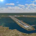
| Bella Coola CYBD in British Columbia, Canada |
|
Images related to this file:
File Description:
Bella Coola is in one of the deep east-west fjords amid the Coastal Range on the coast of BC, approximately mid way between Vancouver and the Alaskan border and some 70 miles inland from the open ocean. The town of Bella Coola has a small population of around 150, while the population of the whole Bella Coola Valley is around 2,000. The valley is warmer in both summer and winter than the surrounding area, and tourism flourishes along with forestry, fishing, and local government administration. Although there is road access, the ferry service is the main connection to larger coastal towns or cities such as Vancouver. The airport, 7 miles east of the town, is connected by daily Pacific Coastal flights to Vancouver and Anahim Lake (to the east). The asphalt runway is 4,200 feet long and aligned 04-22 in FS9 (by 2010 this had changed to 05-23 in reality) and is without lighting of any sort, so it is restricted to daylight hours only. At the eastern end is the terminal building and in the middle the West Coast Helicopter hangar, which has a large fenced paddock-like enclosure in front of it. The helicopters hop over the three feet high fence as they "taxi" to the apron in front of the hanger (but not in FS9!). Between the two there are four other company hangars spread out along the roadway beside the fence. I have never seen the airfield in Summer, and I have not attempted to replicate the apron as it now shows in Google Earth. The screenshots show the main and overwhelming feature of Bella Coola, the large valley amid the steep mountains. This terrain has an inevitable effect on the ai, in that you will never see a plane land as it hits solid rock before it makes it to the runway. You will, however, see them take off. Pacific Coastal currently flies Beechcraft 1900's to Bella Coola; I have used the Saab 340 which I have seen there some years ago and which I prefer.
| Filename: | Bella_Coola_CYBD_in_British_Columbia_Canada.zip |
| License: | Freeware, limited distribution |
| Added: | 25th October 2018, 17:57:06 |
| Downloads: | 282 |
| Author: | Roger Wensley |
| Size: | 14.57 MB |
| Category: Flight Simulator X - AFCAD Files | |
| PAOT - Wien Meml - Kotzebue, Alaska |
|
Images related to this file:
File Description:
This AFCAD of the airport Wien Meml - Kotzebue (PAOT), Alaska, fixes some issues for Scenery Solution's UTX Alaska users who want to use mesh and texture resolutions better than 38 m and 1 m, respectively. Unfortunately this discloses some additional problems with lagoons surrounding runway 09/27. Some of the ponds had been elevated over apron level, the fence Microsoft had drawn around the airport ran through (elevated) water and so on. Runway 27 has no direct connection to the mainland like it is realized by UTX and furthermore a lot of water polygons (including the lagoons) had 'forgotten' shore line vectors. Included corrections are: fixed main waterpolygons around the airport (according to Google Maps), fixed airport layout, including aprons, GA parking, additional airport buildings (default FSX objects), fixed Runway designators (now 09/27 resp. 18/36 instead of 08/26 and 17/37, Nov. 2013), added shoreline vectors (compatible to UTX textures) and some more.
Again, THIS AFCAD IS INTENDED FOR USERS OF UTX ALASKA ONLY and will likely look horrible in other environments as it partially amends missing features only.
| Filename: | PAOT__Wien_Meml__Kotzebue_Alaska.zip |
| License: | Freeware, limited distribution |
| Added: | 3rd February 2014, 14:30:10 |
| Downloads: | 409 |
| Author: | Axel Birsul |
| Size: | 1.09 MB |
| Category: Flight Simulator X - Scenery | |
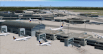
| Frankfurt Main Airport (EDDF) v7 - manual install package |
|
Images related to this file:
File Description:

This major update represents EDDF in the December 2012 timeframe.
With the increasing development of the proposed Terminal 3 area now in use as extended apron parking, this update provides operational ramps for G and H gates including ramp parking for both airline and cargo aircraft, helicopter parking at gates H8 and H12, apron night lighting, vehicular traffic etc. In addition this update features a new Gmax custom fuel tank farm along with custom Frankfurt logos, the recently opened A-plus terminal (7 new gates including 4 A380 gates) in October 2012, a new Air Rail Center model and a new set of cargo offices/buildings that have been placed in the South Cargo area as well as the replacement of the standard FSX blast fences with a new Gmax fence model which adds even further realism to this scenery.
Also, a first time feature for this scenery, it now supports GSX (Ground Services for FSX). The G and H aprons have been customized to support GSX functionality with the correct positioning of the ground service vehicles and pushback operations based on scenery topology. The associated airport .ini file is supplied in this package.
Default FSX scenery is required. See readme/help file for more details.
| Filename: | Frankfurt_Main_Airport_EDDF_v7__manual_install_pac.zip |
| License: | Freeware |
| Added: | 23rd December 2012, 22:29:21 |
| Downloads: | 6,001 |
| Author: | Mark Aldridge |
| Size: | 13.82 MB |
| Category: Flight Simulator 2004 - Scenery | |
| Lac des Plages grass strip in Quebec Canada |
|
Images related to this file:
File Description:
Lac des Plages is in Quebec on the north shore of the lake (and village) of the same name, some 55 miles northeast of Ottawa. It is an old grass strip and next to a tourist trailer park ("caravan" to the English). The runway is almost north-south and 2,200 feet long, and I went there to see if it is still in use. It is in good condition but there was nobody to ask (in early April) if it is still used and nobody turned up see if a plane had landed. I doubt if it is used regularly as there are no "wear" marks that show up on a grass strip, and the flare pots (actually old wheel rims with charcoal in them?) beside the runway could have been lit three months ago or three years ago, there was no way to tell. The single hangar is obviously no longer in use as a hangar, and the lack of a fence between the trailers and the grass strip would be a danger to pilot and strolling pedestrian alike. However, the runway still exists and here it is and as in real life the northern end slopes unevenly up.
| Filename: | Lac_des_Plages_grass_strip_in_Quebec_Canada.zip |
| License: | Freeware, limited distribution |
| Added: | 10th May 2010, 16:03:42 |
| Downloads: | 282 |
| Author: | Roger Wensley |
| Size: | 1.33 MB |
| Category: Flight Simulator X - Scenery | |
| Frankfurt Main Airport (EDDF) v7 - auto install |
|
Images related to this file:
File Description:
This major update represents EDDF in the December 2012 timeframe.
With the increasing development of the proposed Terminal 3 area now in use as extended apron parking, this update provides operational ramps for G and H gates including ramp parking for both airline and cargo aircraft, helicopter parking at gates H8 and H12, apron night lighting, vehicular traffic etc. In addition this update features a new Gmax custom fuel tank farm along with custom Frankfurt logos, the recently opened A-plus terminal (7 new gates including 4 A380 gates) in October 2012, a new Air Rail Center model and a new set of cargo offices/buildings that have been placed in the South Cargo area as well as the replacement of the standard FSX blast fences with a new Gmax fence model which adds even further realism to this scenery.
Also, a first time feature for this scenery, it now supports GSX (Ground Services for FSX). The G and H aprons have been customized to support GSX functionality with the correct positioning of the ground service vehicles and pushback operations based on scenery topology. The associated airport .ini file is supplied in this package.
Default FSX scenery is required. See readme/help file for more details.
| Filename: | Frankfurt_Main_Airport_EDDF_v7__auto_install.zip |
| License: | Freeware |
| Added: | 23rd December 2012, 22:28:57 |
| Downloads: | 12,700 |
| Author: | Mark Aldridge |
| Size: | 13.43 MB |
| Category: Prepar3D V1-4 - Scenery | |
| EPBK - Bialystok-Krywlany 2020 |
|
File Description:
EPBK - Białystok-Krywlany 2020 - P3D V4.5 Scenery
PL:
Prosta sceneria lotniska Białystok-Krywlany i landclass miasta oraz okolic.
EPBK:
- zaktualizowane wymiary pasa trawiastego 9L/27R i odpowiednie położenie
- dodany nowy asfaltowy pas 9R/27L - uzyska certyfikat z dniem 23 maja 2020 - do tej daty wyłączony z użytku
- dodana płyta postojowa przed hangarem
- dodane 2 helipady
- dodane obiekty i ogrodzenie lotniska z domyślnej biblioteki obiektów
MIASTO I OKOLICE:
- dodany domyślny obiekt stadionu w miejscu Stadionu Miejskiego
- dodane najważniejsze ulice i drogi w okolicy lotniska - min. Ciołkowskiego, Mickiewicza, nowa obwodnica miasta - Trasa Niepodległości
- zaktualizowany landclass terenów wokół lotniska
- zaktualizowany kształt lasów na terenie całego miasta oraz w jego okolicach - min. Las Turczyński, Las Solnicki, Las Bacieczkowski
Najlepsze wrażenia wizualne z ORBX Global + Vector i openLC Europe.
ENG:
Simple scenery of the Bialystok-Krywlany airport and the landclass of the city and the surrounding area.
EPBK:
- updated grass runway 9L / 27R
- new asphalt 9R / 27L runway added - will be certified on May 23, 2020 - out of service until this date
- parking apron added
- 2 helipads added
- added objects and airport fence from the default object library
CITY AND VICINITY:
- default stadium object added in place of the City Stadium
- the most important streets and roads around the airport have been added - min. Ciołkowskiego, Mickiewicza, the new city beltway - Independence Route
- updated landclass of areas around the airport
- updated shape of forests throughout the city and in its vicinity - Turczyński Forest, Solnicki Forest, Bacieczkowski Forest and others
| Filename: | EPBK__BialystokKrywlany_2020.zip |
| License: | Freeware |
| Added: | 26th April 2020, 19:05:34 |
| Downloads: | 177 |
| Author: | Åukasz Tyszkiewicz |
| Size: | 8.34 KB |
| Category: Flight Simulator 2004 - Scenery | |
| Dutch Harbour PADU in Alaska PLUS AI Air & Sea |
|
Images related to this file:
File Description:
This is a revised and much-added-to update of my earlier Dutch Harbor post, adding more Air & Sea AI. It is complete in itself and does not require you to have previously installed the original. New parking is for a civilian freighter, a Coast Guard C-130, and Coast Guard helicopters that fly from St Paul Island.
There is also a daily flight from Dutch Harbor to Akutan that will be by the amphibious Goose as there is no land runway at Akutan [more posts follow].
The official airport name is Unalaska, but a seat booked with airlines will be to Dutch Harbor, known from the tv series as a fishing centre with major fish and crab processing plants. In town the largest company is Unisea, taking up all of what was once Expedition Island and the adjacent shoreline. The out-of-town expansion is taking place along the shore of Captains Bay to the southwest, and here the largest is Westward with the uniform green roof for the plant and the residential buildings for seasonal workers.
The airport has just over 3,900 feet of 100 feet wide asphalt, aligned 30/12, lit, and between sea and hill with two aprons at the southeast end. There is no control tower at the airport, so don't be surprised when you are required to contact Cold Bay USAF for landing permission. Runway 30 has at its threshold a road; when a plane is landing or taking off traffic is stopped by barriers and lights. To encourage full use of the runway the fence is made up of plastic rods that bend on impact instead of chainlink topped with barbed wire that will turn a light plane upside down.
| Filename: | Dutch_Harbour_PADU_in_Alaska_PLUS_AI_Air__Sea.zip |
| License: | Freeware, limited distribution |
| Added: | 7th August 2012, 20:56:03 |
| Downloads: | 1,528 |
| Author: | Roger Wensley |
| Size: | 13.4 MB |
© 2001-2026 AVSIM Online
All Rights Reserved
Privacy Policy |