
Where Flight Simulation Enthusiasts Gather from Around the World!
AVSIM Library - Search Results

| Category: Flight Simulator X - Scenery | |
| LIPK - Forlì X |

|
Images related to this file:
File Description:
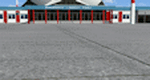
Airport Rinolfi-Forli' for FSX/P3D (all versions), ICAO: LIPK. Also known as Luigi Ridolfi Airport, situated in Forli, Italy.
This is a conversion of Alessandro Monti's FS2004 Scenery. I have added new apron as per Jeppesen's charts and new lights for better vision. Many thanks to Alessandro for the permission of using his FS2004's Scenery, and for Aldo della Vedova for libraries and all the designers that contributed for the objects used.
| Filename: | LIPK__Forl_X.zip |
| License: | Freeware |
| Added: | 11th December 2014, 12:44:37 |
| Downloads: | 2,105 |
| Author: | Andrea Deplano |
| Size: | 5.46 MB |
| Category: X-Plane - Scenery | |
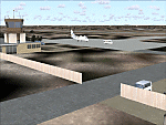
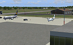
| BR CE - SBJU Juazeiro do Norte v1.1.0 |
|
Images related to this file:
File Description:

This is an X-Plane 11 and X-Plane 10 scenery package for Orlando Bezerra de Menezes Airport (IATA: JDO, ICAO: SBJU), also known as Cariri Regional Airport (Aeroporto Regional do Cariri), is the airport serving Juazeiro do Norte and the Cariri region, in Ceara, Brazil. It includes corrected aprons, ramps, taxiways, lighting system, city buildings, ortho photoscenery for the airfield area, and (XP11 only) ground services (like push back). This scenery was tested and is operational (as of March 22, 2017) in "X-Plane 11 Public Beta #15 64 bit", Windows 10 Home. It was also tested and is also operational (as of March 22, 2017) in "X-Plane 10.51 64 bit", Windows 10 Home. Only the default X-Plane 11 libraries, by Laminar Research, are needed. No third party libraries are used. v1.1.0 adds orthophoto scenery for the airfield area, adjusted ramps stands, city buildings, and now adds XP11 ground services (XP11 omnly).
| Filename: | BR_CE__SBJU_Juazeiro_do_Norte_v110.zip |
| License: | Freeware |
| Added: | 23rd March 2017, 05:19:07 |
| Downloads: | 88 |
| Author: | Rui Mesquita |
| Size: | 14.9 MB |
| Category: Flight Simulator 2004 - Scenery | |
| RAF Burtonwood scenery - Station 590 |
|
File Description:
Scenery for RAF Burtonwood located near Manchester covering the period 1943 to 1953. The largest American airforce base in Europe during WW2, Burton wood handled the assembly/refitting or modification to over 11,000 aircraft during WW2. It was a key factor in the successful outcome of the Berlin airlift of 1947/48 where the 200 hour maintenance inspections were carried out on the C-54 transport aircraft.
Requires also the freeware EZ-scenery library from Abacus which is a self install.
| Filename: | RAF_Burtonwood_scenery__Station_590.zip |
| License: | Freeware |
| Added: | 2nd February 2008, 02:19:26 |
| Downloads: | 1,280 |
| Author: | Glen Broome |
| Size: | 8.73 MB |
| Category: Flight Simulator 2004 - Scenery | |
| Alexandra Airport , New Zealand. NZLX |
|
File Description:
Welcome to Alexandra,a small general aviation airport 2 nautical miles north-north-west of the small town of Alexandra.
The airport is home to the Central Otago Flying Club, and is also home to a number of GA aircraft and gliders.
Alexandra is located in the Central Otago region of the South island of New Zealand.
The scenery includes a GMAX photoreal Terminal/Flying Club building (textures included). Requires some EZ Scenery Object sets (see INSTALL instructions for details).
| Filename: | Alexandra_Airport__New_Zealand_NZLX.zip |
| License: | Freeware, limited distribution |
| Added: | 24th June 2008, 07:55:58 |
| Downloads: | 1,564 |
| Author: | Lawrie Roache / Jamie Marshall |
| Size: | 2.81 MB |
| Category: Flight Simulator 2004 - Scenery Design | |
| EZ-Object Library Part 2 - Fast Food resturants |
|
File Description:
FS2004 FlightLevel390 EZ-Object Library part2
Contains a mixture of 4 low polygon Fast Food Resturants with seperate signage.Dominos Pizza,Sonic,Waffle House & Pizza Hut.
DXT3 day textures with night lighting.Optimized for good FPS.
These objects can be used in your own freeware scenery enhancements and will also be needed for FL390's upcoming KBTRv2 Scenery release.
A seperate 3rd part containing Inland River barges,and a few other goodies will follow this upload soon.Part 3 will also be needed for our KBTRv2 Scenery and Galveston Bay/Houston Ship Channel Water Scenery as part 3 will contain the barges and other objects that will be needed.
Not tested in FS X.
| Filename: | EZObject_Library_Part_2__Fast_Food_resturants.zip |
| License: | Freeware |
| Added: | 24th May 2007, 03:20:43 |
| Downloads: | 1,825 |
| Author: | FlightLevel390/Joe DeGregorio |
| Size: | 3.58 MB |
| Category: Flight Simulator 2004 - Scenery | |
| VAKE Kandla/Gandhidham, India |
|
Images related to this file:
File Description:
Googly scenery for VAKE Kandla/Gandhidham - a small domestic airport
in the state of Gujurat, India, for which little other than a runway is
provided in Flight Simulator 2004. These scenery files add taxiways, aprons,
buildings and other airport features, so that you and your "AI" traffic can
land, taxi, park and take off in a realistic manner.
Gandhidham is a small city about 5 miles from the seaport of Kandla, in the
Gulf of Kutch, and was developed in 1950 after the separation of Pakistan and
India left the key port of Karachi in Pakistan. The airport is served by daily
flights using turboprop aircraft of Air Deccan.
The scenery does not purport to be ultra-accurate. Based on high-detail satellite
imagery from Google Earth, the layout is proportionally correct but the added
airport features, such as buildings, are built from default Microsoft objects
and add-on libraries so will not look exactly like the real thing.
You are not obliged to download and install any additional scenery libraries,
but to enjoy this scenery in its entirety, you may wish to. It will work fine,
with or without.
[File re-uploaded at request of AVSIM]
| Filename: | VAKE_KandlaGandhidham_India.zip |
| License: | Freeware |
| Added: | 14th May 2010, 05:11:31 |
| Downloads: | 848 |
| Author: | John Hinson |
| Size: | 67.36 KB |
| Category: Flight Simulator 2004 - Scenery | |
| LELC Murcia/San Javier, Spain |
|
File Description:
Googly scenery for LELC San Javier, Spain, a medium-sized airport on the Costa
Cálida 17 miles south of Murcia. The airport sees daily scheduled traffic
operated by Canadair Regional Jets and Dash 8 turboprops of Air Nostrum but a
large proportion of the airport's traffic is derived from tourist charter
traffic from operators such as Air Berlin, Easyjet, LTU International and
Ryanair and the airport can accept aircraft as large as the Boeing 767. The
north end of the airport is home to the Spanish Air Force Academy.
Flight Simulator 2004 has made little provision for traffic with facilities only
for general aviation aircraft and this scenery seeks to redress the situation.
The scenery does not purport to be ultra-accurate. Based on high quality
satellite imagery from Google Earth, the layout is proportionally correct but the
added airport features, such as buildings, are built from default Microsoft objects
and add-on libraries so will not look exactly like the real thing.
You are not obliged to download and install any additional scenery libraries,
but to enjoy this scenery in its entirety, you may wish to. It will work fine,
with or without.
| Filename: | LELC_MurciaSan_Javier_Spain.zip |
| License: | Freeware |
| Added: | 6th April 2008, 20:35:29 |
| Downloads: | 3,169 |
| Author: | John hinson |
| Size: | 20.51 KB |
| Category: Flight Simulator 2004 - Scenery | |
| HTMS Moshi |
|
File Description:
Googly scenery for Moshi (ICAO: HTMS), a small airport serving the town of the same name
located in the lower slopes of Africa's highest mountain - Mount Kilamanjaro.
The town boasts good quality education and medical facilities, and industry
includes production of fizzy drinks, beer, flour, animal feed and furniture,
but surprisingly little tourism activity has been developed here so much of
the traffic at this airport is unscheduled and charter work using smaller
aircraft.
Microsoft have only provided wrongly-positioned runways at this airport in
Flight Simulator 2004 and this scenery seeks to redress the situation
so that you and your "AI" traffic can use the airport.
The scenery does not purport to be ultra-accurate. Based on high quality
satellite imagery from Google Earth, the layout is proportionally correct but the
added airport features, such as buildings, are built from default Microsoft objects
and add-on libraries so will not look exactly like the real thing.
You are not obliged to download and install any additional scenery libraries,
but to enjoy this scenery in its entirety, you may wish to. It will work fine,
with or without.
| Filename: | HTMS_Moshi.zip |
| License: | Freeware |
| Added: | 12th October 2008, 10:22:59 |
| Downloads: | 1,079 |
| Author: | John Hinson |
| Size: | 61.84 KB |
| Category: Flight Simulator 2004 - Scenery | |
| VABP Bhopal/Bairagarh, India |
|
Images related to this file:
File Description:
Googly scenery for VABP Bhopal/Bairagarh, India - an enhancement to the
airport provided in Flight Simulator 2004 which is incorrect in many respects.
These scenery files enlarge the apron to a realistic size to accept scheduled
traffic, remove spurious taxiways (they were actually perimeter tracks!), and
add buildings and other airport features so that you and your "AI" traffic
can land, taxi, park and take off in a realistic manner.
This small domestic airport is served by Boeing and Airbus jets of Indian
Airlines and Jet Airways together with local flights operated by ATRs of Air
Deccan.
The scenery does not purport to be ultra-accurate. Based on high-detail satellite
imagery from Google Earth, the layout is proportionally correct but the added
airport features, such as buildings, are built from default Microsoft objects
and add-on libraries so will not look like the real thing.
You are not obliged to download and install any additional scenery libraries,
but to enjoy this scenery in its entirety, you may wish to. It will work fine,
with or without.
[File re-uploaded at request of AVSIM]
| Filename: | VABP_BhopalBairagarh_India.zip |
| License: | Freeware |
| Added: | 7th May 2010, 22:34:06 |
| Downloads: | 1,625 |
| Author: | John Hinson |
| Size: | 64.37 KB |
| Category: Flight Simulator 2004 - Scenery | |
| FNGI N'giva/Ondjiva Pereira, Angola |
|
File Description:
Googly scenery for N'giva - Ondjiva Pereira (ICAO: FNGI, IATA: NGV), an airport
serving Ondjiva, one of Angola's larger cities. Until relatively recently it
possessed little more than a dirt runway but recent expansion has seen the
commissioning of a longer asphalt runway and a terminal area. Today, the airport
sees passenger and cargo flights from airlines such as Air Gemini, Angola
Airlines, Savanair and Sonair utilising a variety of aircraft from the little
Let 410 turboprop through to Boeing 737 jets.
Microsoft have only provided the dirt runway at this airport in Flight Simulator
2004 and this scenery seeks to redress the situation so that you and your
"AI" traffic can use the airport realistically.
The scenery does not purport to be ultra-accurate. Based on high quality
satellite imagery from Google Earth, the layout is proportionally correct but the
added airport features, such as buildings, are built from default Microsoft objects
and add-on libraries so will not look exactly like the real thing.
You are not obliged to download and install any additional scenery libraries,
but to enjoy this scenery in its entirety, you may wish to. It will work fine,
with or without.
| Filename: | FNGI_NgivaOndjiva_Pereira_Angola.zip |
| License: | Freeware |
| Added: | 15th October 2008, 12:40:17 |
| Downloads: | 1,607 |
| Author: | John Hinson |
| Size: | 73.94 KB |
© 2001-2026 AVSIM Online
All Rights Reserved
Privacy Policy |