
Where Flight Simulation Enthusiasts Gather from Around the World!
AVSIM Library - Search Results

| Category: Flight Simulator 2004 - Aircraft Repaints, Textures and Modifications | |
| Zambia Airways DHC-2 Beaver c1966 |

|
Images related to this file:
File Description:
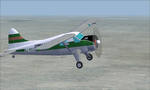
This is a repaint of a DHC-2 Beaver in Zambia Airways colors. The freeware DHC-2 Beaver (wheels) by John L. Woodward is needed for this repaint. It is an FS2004 plane, but I flew it in FSX-SE using the default Beaver panel. The plane can be downloaded here on Avsim, file name: beaver_wheels_2005.zip. Zambia Airways was formed as a subsidiary of Central African Airways (CAA) in April 1964. When CAA collapsed in 1967, Zambia Airways became a fully Zambian owned carrier. In 1968, the fleet consisted of DHC2 Beavers, DC-3s, and two newly delivered BAC-111s from the defunct CAA. They flew on regional routes to Kenya, Malawi, Tanzania, and Mauritius. Alitalia was also hired to provide support of the initiation of new international services. A Douglas DC-8-43 leased from Alitalia was used for the long-haul Lusaka to London flights, which were inaugurated in November 1968, via Nairobi and Rome. In 1970 Zambia Airways took delivery of 3 HS-748s, and in 1974 they received their first Boeing liner; the 707-343C. One year later the two BAC-111s were sold to Dan-Air. July 1976 saw the delivery of the carrier's first 737-200. Zambia Airways received their first wide-body DC-10-30 in July 1984. Zambia Airways did well financially over the years, but by the end of the 1980s and early 1990s, things were a bit more complicated. With financial difficulties facing Zambia Airways, it was forced into liquidation in December 1994. Zambia Airways operated a total of 4 DHC-2 Beavers on local services. This aircraft, 9J-RFZ, was with the airline from 1964 to 1967. This repaint should work on FSX & FS2004. Textures are 32bit BMP.
| Filename: | Zambia_Airways_DHC2_Beaver_c1966.zip |
| License: | Freeware |
| Added: | 22nd August 2019, 08:34:05 |
| Downloads: | 82 |
| Author: | Ted Giana |
| Size: | 2.48 MB |
| Category: Flight Simulator X - Scenery | |
| LJLJ Ljubljana Joze Pucnik Airport |
|
File Description:
Ljubljana Joze Pucnik Airport (IATA: LJU, ICAO: LJLJ) also known by its previous name Brnik Airport, is the international airport of Ljubljana, Slovenia. The airport is located near the village of Brnik, 19 km (12 mi) north of Ljubljana
and 11 km (6.8 mi) south of Kranj on the road between Kranj and Menges. It has a 3,300 m �� 45 m (10,827 ft �� 148 ft) paved runway. Letalisce Brnik was opened on December 24, 1963.
In 2007, the central-right government controversially renamed the airport to Ljubljana Joze Pucnik airport. Joze Pucnik was a Slovene public intellectual, dissident, and politician, leader of the Democratic Opposition of Slovenia (Demos)
between 1989 and 1992.
The airport is home to Adria Airways, the Slovenian flag carrier. There are currently two low-cost carriers serving the airport, EasyJet and Wizz Air. A few other airlines also serve the airport.
On December 8, 2004, the airport received its first annual millionth passenger. Overall, the airport handled 1,369,485 passengers in 2011, down from 1,673,050 passengers in 2008. It is the only airport in Slovenia with scheduled air
traffic.
The airport is served by a motorway exit off the A2 motorway and by bus service connecting it with Ljubljana and Kranj. A rail line to both cities is planned as well.
Airport is equipped with ILS Cat IIIb on runway 30. NDB and VOR approach are also available.
The runway of the Ljubljana Joze Pucnik Airport was closed to air traffic in April 2010. During that time, the entire width of the asphalt surface of the runway was renovated, as well as the asphalt surface on some parts of taxiways.
This file has the right coordenates, apron and characteristics of the airport, airport vehicules and buildings, Airport charts included.
| Filename: | LJLJ_Ljubljana_Joze_Pucnik_Airport.zip |
| License: | Freeware |
| Added: | 22nd November 2012, 16:29:14 |
| Downloads: | 1,510 |
| Author: | Anwar Gonzalez |
| Size: | 1.84 MB |
| Category: Flight Simulator 2004 - Flight Plans | |
| Military Base Tour - Pacific Rim |
|
File Description:
Military Base Tour – Pacific Rim (MFPR) contains 21 Flight Plans (.PLN) for flights to various military air bases along the Pacific Rim, across the Pacific to CONUS and ending at Andrews AFB/NAF where the Military Flights Series began. It is the continuation of Military Flight Plans (MF) (mf_flights.zip) published in Avsim on 29th March 2004, Military Flight Plans – Europe (MFE) (mfe_flights.zip) published in Avsim on 17th June 2004 and Military Base Tour – West Asia (MFWA) (mfwa_flights.zip) published in Avsim on 6th August 2004 and Military Base Tour – South Asia (MFSA) (mfsa_flights.zip) published in Avsim on 20th November 2004. There are a total of 128 flight plans in this Military Flight Series - Round the World Tour of Military Bases. (See Military Flights Master Itinerary– included in this .zip.) The itinerary contains a list of all the plans in the five uploaded files.) There are Briefing documents for each flight in Microsoft Word (.doc) and Text (.txt). The Flight Plans use the autopilot from takeoff to landing. The speed, altitude, weather, radios and various other controls are the pilot’s responsibility. Many landings are IFR and all are under the control of the autopilot. It is suggested that the pilot set up a separate Folder (“MFPR Flights” for example) and unzip this file there to store the .PLN and Briefing files. The .PLN can then be copied to the “Flight Simulator Files” and used to set up the flight and the Briefings printed and available for quick reference during the flight.
| Filename: | Military_Base_Tour__Pacific_Rim.zip |
| License: | Freeware |
| Added: | 9th April 2005, 04:39:05 |
| Downloads: | 1,382 |
| Author: | John Resch |
| Size: | 282.22 KB |
| Category: Flight Simulator 2004 - Aircraft Repaints, Textures and Modifications | |
| KLM Douglas DC-3 pre-war |
|
Images related to this file:
File Description:
Re-upload. FS2004 KLM Douglas DC-3 pre-war textures.
Before and after World War II, KLM was a major European operator of the Douglas DC-3. The first DC-3, PH-ALI 'Ibis', entered service with KLM in October 1936. This made KLM the first operator of the DC-3 in Europe.
22 others would join before Nazi-Germany invaded the Netherlands on 10 May 1940 and occupied the country for five dark years. Those DC-3's present at Amsterdam-Schiphol, if not destroyed by bombs, were impounded by the Germans. Other DC-3's that happened to be elsewhere out of reach of the enemy found their way either to the Dutch East Indies where they served on the KNILM routes until the Japanese invasion in February 1942, or to England where they were leased by BOAC for the London (later Bristol) to Lisbon service.
Both PH-ALI 'Ibis' and PH-ARW 'Wulp' moved to England. Unfortunately they did not survive World War II. The 'Wulp' was destroyed in November 1940 when Bristol got bombed by
the German Luftwaffe. The 'Ibis' was shot down by Junkers Ju-88's on 1 June 1943 over the Bay of Biscay.
The repaints of PH-ALI and PH-ARW are based on the templates Mark Beaumont created for the MAAM-SIM Douglas DC-3 (passenger version), which were based on Jan Visser's original textures. These are textures only. You will require MAAM-SIM's great donationware Douglas R4D/DC-3 package. Repaints by Maarten Brouwer.
| Filename: | KLM_Douglas_DC3_prewar.zip |
| License: | Freeware, limited distribution |
| Added: | 12th June 2010, 01:16:55 |
| Downloads: | 666 |
| Author: | Maarten Brouwer |
| Size: | 10.05 MB |
| Category: Flight Simulator 2004 - Scenery | |
| CYYQ - Churchill Port & York Factory - Northern Manitoba, Canada |
|
Images related to this file:
File Description:
The main part of this scenery installs the Port of Churchill and the grain silos. Churchill CYYQ has been made by Sidney Schwartz, and this also adds AI and slightly modifies his parking to make a space big enough for Buffalo's C46. Churchill is in northern Manitoba, on the Churchill River where it empties into Hudson Bay. The town is accesible by air, by boat (once the winter ice melts) and most importantly by rail from the south. Grain from the Canadian prairies is hauled north and stored in Churchill for export to Europe by a sea route that is significantly shorter than any other, and there is a grain carrier included in the AI. Today there are perhaps 810 people living in Churchill, a slowly declining number. There are also a number of impressive polar bears. There was another port south of Churchill, but it was never completed, never connected to a railroad track, and never used. It was called Port Nelson, and was at the mouth of the Nelson River. Nearby, on the Hayes River, there is an old trading post called York Factory, built in 1684 and preserved as part of the living history of the north of Canada. The second scenery is for this, and for the nearby tourist camp called Silver Goose Lodge, which as the name suggests is for hunters. The large grassy area alongside the fort was for the trappers to camp on when they all arrived in early summer to trade the furs for goods.
| Filename: | CYYQ__Churchill_Port__York_Factory__Northern_Manit.zip |
| License: | Freeware, limited distribution |
| Added: | 23rd July 2014, 02:26:04 |
| Downloads: | 542 |
| Author: | Roger Wensley |
| Size: | 3.69 MB |
| Category: Prepar3D V1-4 - Scenery | |
| EPBK - Bialystok-Krywlany 2020 |
|
File Description:
EPBK - Białystok-Krywlany 2020 - P3D V4.5 Scenery
PL:
Prosta sceneria lotniska Białystok-Krywlany i landclass miasta oraz okolic.
EPBK:
- zaktualizowane wymiary pasa trawiastego 9L/27R i odpowiednie położenie
- dodany nowy asfaltowy pas 9R/27L - uzyska certyfikat z dniem 23 maja 2020 - do tej daty wyłączony z użytku
- dodana płyta postojowa przed hangarem
- dodane 2 helipady
- dodane obiekty i ogrodzenie lotniska z domyślnej biblioteki obiektów
MIASTO I OKOLICE:
- dodany domyślny obiekt stadionu w miejscu Stadionu Miejskiego
- dodane najważniejsze ulice i drogi w okolicy lotniska - min. Ciołkowskiego, Mickiewicza, nowa obwodnica miasta - Trasa Niepodległości
- zaktualizowany landclass terenów wokół lotniska
- zaktualizowany kształt lasów na terenie całego miasta oraz w jego okolicach - min. Las Turczyński, Las Solnicki, Las Bacieczkowski
Najlepsze wrażenia wizualne z ORBX Global + Vector i openLC Europe.
ENG:
Simple scenery of the Bialystok-Krywlany airport and the landclass of the city and the surrounding area.
EPBK:
- updated grass runway 9L / 27R
- new asphalt 9R / 27L runway added - will be certified on May 23, 2020 - out of service until this date
- parking apron added
- 2 helipads added
- added objects and airport fence from the default object library
CITY AND VICINITY:
- default stadium object added in place of the City Stadium
- the most important streets and roads around the airport have been added - min. Ciołkowskiego, Mickiewicza, the new city beltway - Independence Route
- updated landclass of areas around the airport
- updated shape of forests throughout the city and in its vicinity - Turczyński Forest, Solnicki Forest, Bacieczkowski Forest and others
| Filename: | EPBK__BialystokKrywlany_2020.zip |
| License: | Freeware |
| Added: | 26th April 2020, 19:05:34 |
| Downloads: | 177 |
| Author: | Åukasz Tyszkiewicz |
| Size: | 8.34 KB |
| Category: Flight Simulator 2004 - Aircraft Repaints, Textures and Modifications | |
| jazeera AIRWAYS Airbus A320-214 (9K-CAL) |
|
Images related to this file:
File Description: Jazeera Airways is a low-fare airline with its head office on the grounds of
Kuwait International Airport in Al Farwaniyah Governorate, Kuwait. It operates
scheduled services to the Middle East and Europe. Its main base is Kuwait
International Airport. The airline has grown since its launch to become Kuwait's
second national airline and has been dynamic in popularizing low-cost carriers
in the Middle East. Jazeera Airways is one of the largest operators at Kuwait
airport, having handled a quarter of all aircraft movements and passengers at
the airport during July 2009. According to the July 2009 report issued by Kuwait
Directorate General for Civil Aviation's, Jazeera Airways had the largest number
of aircraft movement in the month with 1834 take-offs and landings, overpassing
the second largest carrier in aircraft movement by 4%.

Jazeera's livery is painted on Project Airbus's Airbus A320-214 aircraft
(included). The textures are saved in 32bit format for quality graphics.
Textures are also characterized by HD (High Definition). Its features are
idle-reverser animation, animated pack vents and pressurisation outflow valve,
detailed textures, accurate paint, dynamic shine & effects, dynamic flexing
wings that respond to turbulence, fully independent suspension, trim animation,
gear steering, accurate flight dynamics, spoiler animation, reflective cockpit
windows, improved wingflex code with input from several new parameters including
ground spoilers, fuel load, and angle of attack, transparent navigation light
lenses and many more. Visit my facebook page "Aviation Art Paintings by Giacomo
Tomasini" for news, updates and previews on my future repaint projects: https://www.facebook.com/AviationArtPaintings
. Thanks for downloading & Happy flying.
| Filename: | jazeera_AIRWAYS_Airbus_A320214_9KCAL.zip |
| License: | Freeware |
| Added: | 16th July 2013, 15:59:40 |
| Downloads: | 578 |
| Author: | Giacomo Tomasini |
| Size: | 19.81 MB |
| Category: Flight Simulator 2004 - Scenery | |
| CYKF - Kitchener, Regional Muni of Waterloo - Ontario Canada |
|
Images related to this file:
File Description:
The town of Kitchener is in southern Ontario, 40 miles southwest of Toronto. The population is just over half a million, including the adjoining Cambridge and Waterloo which are known locally as the Tri Cities. The Kitchener name was adopted in 1916, replacing the former "City of Berlin".
The airport is on the northeastern side of the town, with the main runway aligned 08-26 and just over 7,000 feet of asphalt 150 feet wide, lit, with PAPI at both ends and approach lighting and ILS on 26. The second runway is aligned 14-32 and is 4,100 feet long, lit and with PAPI at both ends; right hand circuits for 32. The airport is being steadily enlarged and improved, with new hangars for rental, operators, and maintenance companies. The largest and most visible presence is the training operation located just off the southwest end of taxiway A, where there are 14 Cessna 172, 2 Cessna 152, 2 Piper Seminole, and others. These are represented in the AI. There are morning and evening scheduled flights by Westjet to Calgary and American Eagle to Chicago, also in the AI. To the southwest, past taxiway C, there is GA parking; request taxi to what is named here "southwest parking" where there are spaces on both grass and asphalt. To the southeast, along a taxiway off the southeast corner of the main apron, are mainly operators and maintenance facilities. This version of CYKF includes the new(ish) terminal, the first of the new central rental hangars alongside the new taxiway and access road, and the very new large hangar off taxiway C, but not the new airport services building (fire and snow clearance) that is off to the southeast of taxiway A, and not the new car park to the south of the airport access road. So an uncertain and possibly historically innacurate date, but with the correct taxiway lighting and signage, and building textures from photographs.
| Filename: | CYKF__Kitchener_Regional_Muni_of_Waterloo__Ontario.zip |
| License: | Freeware, limited distribution |
| Added: | 7th May 2016, 21:13:28 |
| Downloads: | 547 |
| Author: | Roger Wensley |
| Size: | 28.69 MB |
| Category: Flight Simulator 2004 - Scenery | |
| Dawson Creek CYDQ in British Columbia, Canada |
|
Images related to this file:
File Description:
Dawson Creek is at 2,148 feet asl just east of the Rocky Mountains, less than 10 miles west of the BC/Alberta border. The Peace River, 25 miles north of Dawson Creek, links the two sides of the Rockies, winding through peaks that reach up almost to 8,000 feet. The population grew when the Northern Alberta Railway was extended to Dawsons Creek in 1932, and grew even more more when the Alaska Highway was built in 1942 and Dawsons Creek was where it started from. The airport is just to the east of the town. The runway is 5,000 feet of wide asphalt (150 feet) aligned 06/24, lit, and with PAPI and approach lights. There is a water runway to the north of the main runway with the same alignment, separately designated as Dawson Creek CBD3. The two operate as one; traffic for both use the mandatory frequency of 122.2 and talk to one controller in one control tower. However, in FS9 the ATC for two separately designated airfields operates as if they are nowhere near each other and near misses are the result. I have put them both in un-manned tower mode so you will announce your position and intentions and select your own parking spots etc. There is in reality a lack of apron markings but I have marked the positions of both gates. The apron is not large so there is only one other apron parking spot (see the traffic cone) and most parking is either next to one of the hangars or on the grass. The aprons vary from asphalt, to concrete, onwards to gravel, and then further onwards to some gravel amid the bare dirt; I have replicated this variation as far as FS9 permits. The buildings are bespoke from photos. The AI includes Central Mountain Air with two daily scheduled flights and Northern Cariboo as one of the airlines that occasionally runs charter flights in CYDQ. There are also private GA flights, and float plane flights into and out of CBD3.
| Filename: | Dawson_Creek_CYDQ_in_British_Columbia_Canada.zip |
| License: | Freeware, limited distribution |
| Added: | 22nd November 2013, 23:31:40 |
| Downloads: | 651 |
| Author: | Roger Wensley |
| Size: | 16.65 MB |
| Category: Flight Simulator X - Aircraft Repaints, Textures and Modifications | |
| Consolidated PBY-5 RNZAF 6 Sqn XX-W |
|
Images related to this file:
File Description:
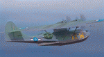
A repaint for the Aerosoft PBY-5 Catalina in the colors of NZ4020 XX-W of the RNZAF. Bu08435, it flew with 6 Flying Boat Squadron. Following Japan's entry into the war in December 1941, the RNZAF had to switch from primarily training pilots to Europe into a combat force. No. 6 Squadron RNZAF was formed as an army co-operation unit at Milson in February 1942 flying Vickers Vildebeest and Hawker Hind aircraft. At the same time, No. 5 Squadron RNZAF moved to Fiji with Short Singapores and Vickers Vildebeest and Vincent biplanes. Modern maritime patrol flying boats (and more Hudson light bombers) were requested under Lend Lease and when the first Consolidated Catalinas arrived a detachment of men from No. 5 Squadron was assigned to convert to these types as No. 6 Squadron. Before the squadron was officially formed these men successfully completed their first air-sea rescue of a downed US aircrew. From May 1943 No. 6 squadron undertook action against the Japanese. The Squadron also conducted search and rescue missions for allied aircrew and seamen, and undertook many open sea rescues. XX-W arrived in Fiji on 21 October 1943. On February 18, 1944 it took off on a dumbo rescue mission to north Buka Island and landed to rescue two crew members and pick up a dead body from the crash of B-25, and successfully returned them to Halavo. On 26 May 1945, it stalled on landing at Hobsonville and was towed to its mooring by a crash boat. The induced damage resulted in the aircraft being written off charge on 18 June 1945.
Repaint by Jan Kees Blom, based on the paintkit by Aerosoft
| Filename: | Consolidated_PBY5_RNZAF_6_Sqn_XXW.zip |
| License: | Freeware |
| Added: | 13th July 2018, 20:40:22 |
| Downloads: | 137 |
| Author: | Jan Kees Blom |
| Size: | 8.74 MB |
© 2001-2026 AVSIM Online
All Rights Reserved
Privacy Policy |