
Where Flight Simulation Enthusiasts Gather from Around the World!
AVSIM Library - Search Results

| Category: Flight Simulator 2004 - Scenery | |
| Mackenzie CYZY in British Columbia, Canada |

|
Images related to this file:
File Description:
Mackenzie is around 120 miles west of Peace River and the BC/Alberta border, at the southern end of Williston Lake. The lake is 135 miles long and the population of the town is about 3,500; those figures illustrate typical Canada, a huge area enjoyed by the few. The main occupations relate to timber and mining in some form, plus tourism (in particular winter sports tourism). The airport is 2 miles southwest of the town, with no regular scheduled flights but it is not unusual to find Central Mountain Air there delivering either charter passengers or freight. The single runway is aligned 16-34 and 100 feet wide lit asphalt that is just over 5,000 feet long, with (in 2010 or so) an additional 1,500 feet of gravel. There is PAPI at both ends of the asphalt. The largest operation based at the airfield is a helicopter company, at the northern end of the apron. There is a "mandatory frequency" of 123.5 which is a Canadian invention; you MUST have a radio. There is no control tower at the actual airfield, and if or when there is no response from further afield then you announce your intentions etc. In FS9 there is no way to "switch off or on" the monitoring of a MF radio frequency so you will find that this one is always silent.
| Filename: | Mackenzie_CYZY_in_British_Columbia_Canada.zip |
| License: | Freeware, limited distribution |
| Added: | 27th December 2018, 20:19:05 |
| Downloads: | 131 |
| Author: | Roger Wensley |
| Size: | 19.81 MB |
| Category: Flight Simulator 2004 - AFCAD Files | |
| Southwestern British Columbia Airport Corrections |
|
File Description:
As shorelines, water bodies, roads, railways and other features become more accurate in addon scenery, inaccuracies in airport placement become apparent. Although Microsoft did an excellent job of using published data to place airports, the published information is not always accurate. Some airports in the area of interest were misplaced by as much as 850m, thus conflicting with water and/or roadways. This release corrects Canadian airports in South-western British Columbia, in LOD5 cell 15x14 (915140). This area covers a portion of Vancouver Island from Duncan to Victoria, and the BC Mainland as far east as Douglas Lake and north of Pemberton. In this region CAK3, CAL3, CBT6, CYHE, CYLY, and CYPS are corrected, and Bruce Ellison has kindly modified his CAM3 for inclusion; see separate readme document for details. All these airports have been activated for AI use. A few buildings that may conflict from roads have been removed from CYNJ. The unrealistically large flatten and airport polygon at CYYJ is reduced in size. Airport features that end up in the water have been removed from CYVR and the overly large flatten there reduced. Some Rwy12 goodies have been tossed in as well, but if these are not important to the user, it is not necessary to have Rwy12 installed. Ultimate Terrain or similar accurate hydrology and roads recommended. FSGenesis 38m mesh or other high quality terrain mesh recommended.
| Filename: | Southwestern_British_Columbia_Airport_Corrections.zip |
| License: | Check within download |
| Added: | 30th May 2005, 07:31:45 |
| Downloads: | 3,001 |
| Author: | Jon Patch, Bruce Ellison |
| Size: | 1.53 MB |
| Category: Flight Simulator X - Scenery | |
| Quebec CYQB |
|
File Description:
All pilots have used or heard the word "Quebec" during their radio communication but not many pilots actually landed at Quebec International airport (CYQB). A great number of Head of States, VIPs, tourists came to Quebec City for summits, special occasions or to visit the city declared a World Heritage Site by UNESCO in 1985. Quebec airport is also hosting a great airshow and this year in June, to celebrate the 400th anniversary of Quebec City, five of the world best aerobatic squadrons will perform simultaneously over Quebec: the British "Red Arrows", the French "La Patrouille de France", the US Navy "Blue Angels", the USAF "Thunderbirds" and the Canadian "Snowbirds". It will be quite a sight.
This very accurate scenery will give you the opportunity to visit CYQB with your simulator. Months of effort were devoted to make this scenery as real as possible. This package includes more that 25 highly detailed hangars and buildings all having night textures, some of them have windows with specular effect. Light poles provide aprons lighting. The adjacent mount Belair have communication towers with strobe lights visible for over 12nm which provides a good visual reference coming into the airport. Exceltech, a maintenance facility has static aircrafts parked in front. A second publication will include the new terminal which is presently under construction.
| Filename: | Quebec_CYQB.zip |
| License: | Freeware |
| Added: | 20th February 2008, 22:13:36 |
| Downloads: | 8,240 |
| Author: | Gilles Boily |
| Size: | 6.21 MB |
| Category: Flight Simulator 2004 - Aircraft Repaints, Textures and Modifications | |
| Air Canada Boeing 767-233 early 90's livery (C-GAUP) |
|
Images related to this file:
File Description:
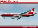
I was contacted some time back by some Canadian simmers looking for a rendition of an Air Canada Boeing 767-200 in the "Maple Leaf" 2 red cheat line livery of the early 1990's. I had been wanting a reason to repaint the Project Opensky Boeing 767 V4 model, so this was my chance. Sadly, Air Canada retired the last 767-200 from service in 2008. This particular airframe, the 5th 767 delivered to Air Canada, was retired around 2002.
This is a detailed repaint with custom textures. All windows are custom, hand-painted, 3D with window shades. The night textures are custom as well. The stewardess is a former Miss Canada, the interior exit signs are in French (SORTIE) and the pushback tug even bears the old Air Canada logos. The repainted textures in this package are 32-bit with no mipmaps for best clarity and quality. I hope you enjoy flying this wonderful aircraft as much as I did creating it. A special thanks to Lorne Jordan who suggested this repaint and supported me on getting it 'just right.' This is a complete install and contains all Project Opensky provided files current to Version 2004.8.0. The sound is from the default B737.
(This is a reupload of a work from April 2009 that was lost as a result of the AVSIM site compromise.)
| Filename: | Air_Canada_Boeing_767233_early_90s_livery_CGAUP.zip |
| License: | Freeware, limited distribution |
| Added: | 24th January 2010, 10:46:04 |
| Downloads: | 1,069 |
| Author: | Project Opensky, Jeffrey S. Bryner |
| Size: | 13.3 MB |
| Category: Flight Simulator 2004 - Aircraft Repaints, Textures and Modifications | |
| British Airways Boeing 787-8 Dreamliner (G-ZBJB) and Boeing 787-9 Dreamliner (G-ZBKB) |
|
Images related to this file:
File Description:

British Airways, often shortened to BA, is the flag carrier airline of the United Kingdom and the largest airline in the United Kingdom based on fleet size. When measured by passengers carried, it is second-largest in United Kingdom (behind easyJet). The airline is based in Waterside near its main hub at London Heathrow Airport. British Airways is a founding member of the Oneworld airline alliance, along with American Airlines, Cathay Pacific, Qantas, and the now defunct Canadian Airlines.
British Airways liveries painted on Tenkuu Developers Studio (TDS) Boeing 787-8 and -9 Rolls Royce Trent 1000 model. The textures are saved in 32bit format for quality graphics. Textures are also characterized by HD (High Definition). Its features are idle-reverser animation, animated pack vents and pressurisation outflow valve, detailed textures, accurate paint, dynamic shine & effects, dynamic flexing wings that respond to turbulence, fully independent suspension, trim animation, gear steering, accurate flight dynamics, spoiler animation, reflective cockpit windows, improved wingflex code with input from several new parameters including ground spoilers, fuel load, and angle of attack, transparent navigation light lenses and many more. REPAINT TEXTURES ARE ALSO COMPATIBLE WITH THE FSX MODEL (needed).
Visit our Facebook page "Sky Level Textures" for news, updates and previews on my future repaint projects. Thanks for downloading & Happy flying. HD GAMING EXPERIENCE inside. https://www.facebook.com/SkyLevelTextures
| Filename: | British_Airways_Boeing_7878_Dreamliner_GZBJB_and_B.zip |
| License: | Freeware |
| Added: | 8th November 2015, 16:23:53 |
| Downloads: | 3,336 |
| Author: | Giacomo Tomasini | Sky Level Textures | Tenkuu Developers Studio (TDS) |
| Size: | 39.89 MB |
| Category: Flight Simulator 2004 - Scenery | |
| FS9 Fort St John CYXJ in BC Canada |
|
File Description:
Fort St John is close to the border between British Columbia and Alberta, around 40 miles north-northwest of Dawson Creek. The airport was originally a Royal Canadian Air Force base, associated with the wartime construction of the Alaska Highway. The airfield was part of this construction effort and the wartime ferrying of planes to Russia. It is currently named "North Peace Regional Airport", or "North Peace Airport"; apparently there has been no final decision?
The date for this scenery is around 2006. I was given an old video tape cassette which was filmed on an uncertain date, but which had to be before the terminal building was renovated in 2007 and totally changed in appearance. The only way to view the video was to play it in the camera and watch it on a small screen. After I had completed everything except the buildings I started to view the video to establish the building appearances and within an hour or so the camera died. It was so old there was no way to repair it, so I then made some new buildings from memory of the video and what was available online. I also used some that I had already made for other scenery but which were similar. I may replace the terminal building that is in this version with a build of the new one, as I know this one is not a very accurate reproduction. The replacement, if I do it, will be towards the end of this year.
The AI included here is for GA, Air Canada Jazz, and two helicopter companies that were (and still are?) based there. One is at the western end of the apron and the other is at the eastern end but separated from the apron. To gain access to the taxiways and runways (so that all airport users follow the same procedures, for safety reasons) the eastern end helicopters just taxi across the grass. The helicopters are used for maintenance trips to the oil and gas fields in the surrounding area. My screenshots show Westjet at the terminal; this is because I have later Canadian AI installed, while the AI included here is only for the time around 2000 to 2010, when Westjet were not flying to Fort St John.
The airport is square in plan, with the apron running along the northern side and two runways forming diagonals. The two runways are 11-29 (6,882 feet long and 200 feet wide, with ILS at the 29 end and PAPI at the other) and 02-20 (6,684 feet long and 200 feet wide, and with PAPI at each end). The eastern side taxiway that runs north-south is not used. The western side taxiway is in use but only as a race track for cars.
Please email me if you find faults, such as a plane without textures.
| Filename: | FS9_Fort_St_John_CYXJ_in_BC_Canada.zip |
| License: | Freeware, limited distribution |
| Added: | 10th October 2022, 14:03:38 |
| Downloads: | 210 |
| Author: | Roger Wensley |
| Size: | 37.49 MB |
| Category: X-Plane - Original Aircraft | |
| B58 Hustler for X-Plane 6.4/6.51 |
|
File Description:
B58 Hustler v1.0 for X-Plane 6.40/6.51 - development of the B58 began in 1951 with 161 planes delivered to SAC between 1960 and 1970. Americas first supersonic jet bomber (mach 2+) the B58 was designed for high speed delivery of nuclear or conventional weapons from long range as a compliment to the B52 subsonic bomber. One of the most sophisticated planes ever developed, the B58 set many speed and altitude records some of which remain unbroken today. With a gross takeoff weight of 163000 lbs the B58 could cary as much as 101000 lbs of fuel (that's almost 60% of the gross weight). One of the most computerized aircraft ever built, the B58 is amazingly easy to fly without any computer assistance (except the one used to run the x-plane simulator). Go to the attached web sit for the fascinating story of the B58 Hustler.
Wing span: 56 ft. 10 in (17.32 m)
Length: 96 ft. 9 in (29.49 m)
Height: 31 ft. 5 in (9.58 m)
Wing Area: 1,542 sq ft (470 sq m)
Weights:
Empty: 55,560 lb (25,201 kg)
Max T/O: 163,000 lb (73,935 kg)
Performance:
Maximum Speed: 1,321 mph (2,125 km/h) @ 63,150 ft (19,248 m)
Combat Ceiling: 63,150 ft (19,248 m)
Record Ceiling: 85,360 ft (26,017 m)
Combat Radius: 1,750 miles (2,816 km) to,
5,577 miles (8,975 km) with inflight refueling
Powerplant:
Four General Electric J79-GE-1 turbojet engines
rated at 10,500 st. or 16,000 st. with afterburners.
| Filename: | B58_Hustler_for_XPlane_64651.zip |
| License: | Freeware, limited distribution |
| Added: | 1st March 2003, 04:25:26 |
| Downloads: | 708 |
| Author: | Robert App |
| Size: | 1.79 MB |
| Category: Flight Simulator 2004 - Scenery | |
| Kugaaruk CYBB and DEW Pelly Bay CWPB in Nunavut, Canada |
|
Images related to this file:
File Description:
Kugaaruk is on the coast of northern mainland Canada on the Boothia Peninsula, 60 miles into a deep north-south fjord-like inlet called Pelly Bay. The name was changed from Pelly Bay in 1999, and the population is around 800. Gjoa Haven is 150 miles to the west, and Hall Beach just over 200 miles to the east. Six miles south of the village, and connected by a gravel road, there is a NWS station and what remains of a DEW Auxiliary Site; the DEW site was closed in 1992, a year after the NWS station became operational. There is also a 3,350 feet long gravel runway beside Barrow Lake 2 miles east of the site, Pelly Bay CWPB. Kugaaruk airfield is adjacent to the village and the 5,000 feet of 100 feet wide gravel runway is aligned 049T/229T where T stands for "true" as opposed to magnetic. There are flights by First Air and Canadian North and the AI includes a daily flight of each from Yellowknife via Gjoa Haven (as per real life) plus a cargo visit by Buffalo. Although the runway is long enough to accomodate a 737 it is not licensed for regular scheduled jet flights; the reason for this is that the approach lighting is "inadequate". Included here is a new .bgl for Gjoa Haven which will remove the small hold short line from the gravel; my mistake.
| Filename: | Kugaaruk_CYBB_and_DEW_Pelly_Bay_CWPB_in_Nunavut_Ca.zip |
| License: | Freeware, limited distribution |
| Added: | 25th November 2012, 00:43:07 |
| Downloads: | 427 |
| Author: | Roger Wensley |
| Size: | 6.1 MB |
| Category: Flight Simulator 2004 - Scenery | |
| CYKF – Kitchener / Waterloo, Ontario, Canada Version 3.0 |
|
File Description: I have now overhauled the CYKF Airport and made it the lively place it is today. I used the Canada Flight Supplement and my real life knowledge of the airport as this is where I do my flight training.
After seeing the traffic in my Southwestern Ontario addon, CYKF 2.1 looked a little bare in comparison, so added more parking and traffic. There are now 35 parking spots and 2 gates. All parking spots and gates have been assigned codes, which like the airline codes for the larger airports will tell the GA aircraft where to park. I organized the different aprons into parking areas. The Waterloo Wellington flight centre is referred to as “North” parking. There are 3 other parking areas as well as the gates. Traffic includes weekly scheduled aircraft that will fly up to the cottage or down south on the weekend etc.
• 35 parking spots, 2 gates
• Extended runway 25/07 and added the new taxiway and renamed the others
• Changed the landclass for the runway 25/07 extension
• Updated the airport in AFCAD for AI to use the runway 25/07 extension
• Added 22 AI flightplans to the 3 already there. AI will model real life training and commercial operations of the airport
• AI use proper Canadian registration codes
• Tested the files to make sure it operates correctly including AI
| Filename: | CYKF__Kitchener__Waterloo_Ontario_Canada_Version_3.zip |
| License: | Freeware, limited distribution |
| Added: | 14th November 2003, 19:39:31 |
| Downloads: | 2,749 |
| Author: | David Voogd |
| Size: | 1.06 MB |
| Category: Miscellaneous Files - General Utilities | |
| Flight plan management table |
|
File Description:
THe Flight management table is an excel file which will help you to monitor weights and time of your flight plan.
You can insert the following info:
-Departure
-Arrival
-Callsign
-Flight number
-Route distance
-Number of pax
-Cost index
-Cruise altitude
-Block fuel, taxi fuel, trip fuel, extra fuel, reserve fuel
You can also manage time by inserting simulation date, start time, cockpit preparation time and many more.
The file also gives you an advice if you make a mistake and will calculate the fuel you have to burn if you have to perform an emergency landing but you are above the max landing weight.
The excel file will then calculate zero fuel weight, gross weight, takeoff and landing weights based on the "active aircraft management table".
It will also calculate off and on block time as well as takeoff and landing time.
You can use this file with any aircraft by adding tamplates to it or using one that is already in the file. At present the tamplates available are:
X plane
-Flight Factor A320 Ultimate
-Zibo mod B738
-IXEG B733
-Aerobask Eclipse 550NG
Prepar3d/Flight sim X
-PMDG B738 NGX
-Majestic Dash 8 Q400
Creating a new tamplate is easy. All you need to do is having weights info about the aircraft you wish to add in hand.
The file is under development which means that I am going to add new feature to it.
A good breefing is the first step for a good flight.
| Filename: | Flight_plan_management_table.zip |
| License: | Freeware |
| Added: | 9th August 2018, 14:21:41 |
| Downloads: | 336 |
| Author: | Luca Tessieri |
| Size: | 17.92 KB |
© 2001-2026 AVSIM Online
All Rights Reserved
Privacy Policy |