
Where Flight Simulation Enthusiasts Gather from Around the World!
AVSIM Library - Search Results

| Category: Flight Simulator 2004 - Scenery | |
| Hay River - Merlyn Carter Airport NT |

|
Images related to this file:
File Description:
This scenery is the Hay River (CYHY)NT, Canada Airport located on the Southern side of Great Slave Lake. This small busy airport is an important part of the moving of freight and passengers to the North. During the spring and fall when the ice roads are not passable and the waterways cannot be used these Northern airports are vital to get the essential into Northern communities. Buffalo Airways is a great user of this airport for moving freight and passengers as well as operating a fleet of fire fighting tankers.
| Filename: | Hay_River__Merlyn_Carter_Airport_NT.zip |
| License: | Freeware, limited distribution |
| Added: | 28th April 2012, 03:32:22 |
| Downloads: | 1,083 |
| Author: | Flight Ontario - Al Gay |
| Size: | 26.09 MB |
| Category: Flight Simulator X - Aircraft Repaints, Textures and Modifications | |
| Douglas - C-47A |
|
Images related to this file:
File Description:
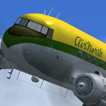
This package adds four diferent new models and textures of the C-47A.
- Douglas C-47A Buffalo Airways C-GPNR
- Douglas C-47A Northwest Territorial C-FNWS
- Douglas C-47A USAAF WWII 268830 "D-Day Doll"
- Douglas C-47A Air North CF-CUG "Lady Lou"
All 3D models were new. The textures are non-mirrored, and high resolution decals were created to provide extra detail to the airline logos, serial numbers and nose and tail artwork.
Each aircraft has its own model features and decal details, trying to be as close as the real life ones.
| Filename: | Douglas__C47A.zip |
| License: | Freeware |
| Added: | 4th January 2013, 13:04:36 |
| Downloads: | 612 |
| Author: | Joao "Muas" Martins |
| Size: | 33.87 MB |
| Category: Flight Simulator 2004 - Aircraft Repaints, Textures and Modifications | |
| Amerer Air Lockheed L-188 Electra (OE-ILA) |
|
Images related to this file:
File Description:
Textures for Chris Buff's Lockheed L-188 - repainted by Manfred Meyer.
You need to download the ELEC-CB.ZIP or L188electra.zip.
These textures depict OE-ILA (c/n 1145) originally delivered 1961 to Western Air Lines as N9746C. The Electra was converted to freighter in 1969 and sold to International Jet Air, Canada as CF-IJJ. In 1972 she came to Europe as LN-MOI for Nordic Air A/S, Norway and 1973 to Fred Olsen. Amerer Air from Linz in Austria bought the plane in September 1997 and used it for freight contract flights throughout Europe until 2006. Sold to Buffalo Airways,Yellowknife, Canada, in 2007 as C-GLBA.
| Filename: | Amerer_Air_Lockheed_L188_Electra_OEILA.zip |
| License: | Freeware |
| Added: | 10th March 2015, 00:03:49 |
| Downloads: | 170 |
| Author: | Manfred Meyer |
| Size: | 1.26 MB |
| Category: Flight Simulator 2004 - Scenery Design | |
| Military Shower Tower and Water Trailer |
|
File Description:
FS2004/FS2002 API macro--Shower Tower with military Water "Buffalo" (Trailer) on top
and 3 shower stalls below for Scenery designers. There is also a stand-alone water trailer in this file. The towers were used in the later times of the war and mostly on very developed firebases. When I was there you stood by the water trailer and used a coffee cup to bathe if you were lucky. If you were not lucky you bathed in a muddy river or not at all. At a minimum you had to haul your own water in Five gallon cans to fill the shower tank.
| Filename: | Military_Shower_Tower_and_Water_Trailer.zip |
| License: | Freeware |
| Added: | 21st May 2006, 23:30:37 |
| Downloads: | 262 |
| Author: | Albert E Simms Jr |
| Size: | 325.79 KB |
| Category: Flight Simulator X - Missions | |
| HelicopterLighthouseMissionsVol37.zip |
|
File Description:
Eight lighthouse tours: Buffalo Main, Cape Zanpa Saki, Currituck, Izumo (2 versions), Ogan Saki, Bel Air, and Sodus Outer.
These missions were programmed in Windows 10 (64bit)for FSX Acceleration and will also work in FSX Steam, P3DV3,V4,V5,and V6. However, several of these tours have specific requirements of Orbx scenery which is detailed in the .txt instructions.
Photos of all the lites are included in each mission set. Once again, be sure to read the instructions in the .txt files. These missions have been thoroughly tested and should work as described. Due to large topographic differences in P3DV5 and V6, there will be peculiarities, but the missions should still work.
| Filename: | HelicopterLighthouseMissionsVol37zip.zip |
| License: | Freeware |
| Added: | 14th April 2025, 19:58:19 |
| Downloads: | 21 |
| Author: | helomissionman |
| Size: | 54.09 MB |
| Category: Flight Simulator 2004 - Scenery | |
| Hay River CYHY, 2010 |
|
Images related to this file:
File Description:
First established as a permanent settlement in 1892, Hay River is located on the south shore of Great Slave Lake in the Canadian Northwest Territories. Like the territorial capital city of Yellowknife 115 miles to the north on the opposite shore of the lake, Hay River experiences brutal weather conditions, with an average mid winter temperature of minus 27C (minus 18F).
* Aprons and taxiways completely redone to be more accurate.
* Missing ground and water features added, land class adjusted.
* All default buildings replaced. Custom terminal building and other custom objects.
* Roads and railroads in vicinity of airport redone.
* Buffalo Airways AI traffic and static water bomber aircraft.
| Filename: | Hay_River_CYHY_2010.zip |
| License: | Freeware |
| Added: | 12th March 2010, 10:14:00 |
| Downloads: | 1,946 |
| Author: | Sidney Schwartz & Peter Ham |
| Size: | 13.2 MB |
| Category: Flight Simulator 2004 - Scenery | |
| Fort Good Hope CZGH - Northwest Territories, Canada |
|
Images related to this file:
File Description:
This is the second in a series of airfields that follow that early access route to the Canadian northern shore, the Mackenzie River. At the far northern end of the river there are Tuktoyaktuk, Inuvik, and Fort McPherson, all posted. Fort Good Hope is at 268 feet ASL and on the east bank of the Mackenzie, 180 miles southeast of Fort McPherson and 100 miles west of Great Bear Lake. The town has a population of around 560, and the main sources of income are from the traditional trapping and hunting. The airport is a mile south of the town, and has almost 4,000 feet of gravel runway. There are scheduled flights to the town by North Wright; I also have two AI GA flights and a Buffalo Airways delivery trip that hops north and south from field to field.
| Filename: | Fort_Good_Hope_CZGH__Northwest_Territories_Canada.zip |
| License: | Freeware, limited distribution |
| Added: | 4th July 2014, 21:03:03 |
| Downloads: | 276 |
| Author: | Roger Wensley |
| Size: | 3.08 MB |
| Category: Flight Simulator 2002 - Flight Plans | |
| Val-U-Prop VA: Ernest K. Gann's 1939 Route |
|
File Description:
Taken from the pages of "Fate is the Hunter" this is Route AM-21 that Ernest K. Gann flew as a co-pilot and pilot in DC-2's and DC-3's in 1938-1940. Included are FS2002 ATC Flight Planner legs for the flight, as well as a text file with all headings, NAVAIDS, approaches and some life-saving tips for flying the route in bad weather. This can be used in any version of FS. Can be flown ATC or as a VOR flight with ILS's, or even as an NDB-only flight in keeping with the period. This is a multi-stop flight: Newark to Wilkes-Barre; to Syracuse; to Rochester; Buffalo; Erie, and finally to Cleveland. Each leg has a separate Flight Planner leg. An official Val-U-Prop VA flight.
| Filename: | ValUProp_VA__Ernest_K_Ganns_1939_Route.zip |
| License: | Freeware |
| Added: | 8th March 2003, 00:59:50 |
| Downloads: | 512 |
| Author: | James Underwood |
| Size: | 6.13 KB |
| Category: Flight Simulator 2004 - Scenery | |
| The Greater Toronto Area for Ultimate Terrain 1.2 Part 1 |
|
File Description:
Part 1 of Flight Ontario's scenery for the Greater Toronto Area for Ultimate Terrain. The scenery is bounded by Detroit in the west, Kingston in the east, Huntsville in the north and Buffalo in the south and features: * all-season scenery * custom water textures * completely modelled Toronto Airports...CYTZ (Toronto Island) and CYZD (Downsview-home to Bombardier Aerospace and the Canadair Regional Jet and Dash-8, and the Toronto Aerospace Museum) * Niagara Helicopters CPQ3 (NEW) *custom autogen for the GTA * Custom landclass for southern Ontario * prominent features around Hamilton include the Burlington Skyway,lift bridge and steel mills * the Welland Canal is featured with lift bridges from Pt Weller to Pt Colborne * the Niagara area includes two hydro generating plants with reservoirs * compatibility with SimFlyers CYYZ.
This scenery is downloadable in two parts and both parts are essential.
| Filename: | The_Greater_Toronto_Area_for_Ultimate_Terrain_12_P.zip |
| License: | Freeware |
| Added: | 31st December 2005, 18:39:52 |
| Downloads: | 13,893 |
| Author: | Jim Kanold - Flight Ontario |
| Size: | 62.05 MB |
| Category: Flight Simulator 2004 - Scenery | |
| Arviat CYEK in Nunavut, Canada |
|
Images related to this file:
File Description:
Arviat is a small town on the west coast of Hudson Bay in Nunavut, around 90 miles south of Whale Cove, 130 miles south of Rankin Inlet, and 160 miles north of Churchill. The airfield is just south of the town, and the 4,000 feet of gravel runway is aligned 149T/329T; these are true bearings and not magnetic as Arviat is just inside the Northern Domestic Airspace zone. There is 100LL fuel available in drums, with 2 hours prior notice. The visiting AI airline is Calm Air, plus a cargo delivery by Buffalo Air. As a town of 2,200 people is too large to model I have used a landclass with autogeneration. The result includes some trees, which is not realistic, but there was no way out. There is a special note in the instructions regarding Flight Ontario replacement textures and "glowing" gravel aprons.
| Filename: | Arviat_CYEK_in_Nunavut_Canada.zip |
| License: | Freeware, limited distribution |
| Added: | 6th January 2012, 16:13:45 |
| Downloads: | 506 |
| Author: | Roger Wensley |
| Size: | 2.19 MB |
© 2001-2026 AVSIM Online
All Rights Reserved
Privacy Policy |