
Where Flight Simulation Enthusiasts Gather from Around the World!
AVSIM Library - Search Results

| Category: Flight Simulator X - Scenery | |
| North Central Ecuador v3, including SEQM (SEQU) and SEIB |

|
Images related to this file:
File Description:
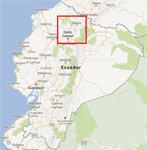
FSX/P3D Version 3 of this scenery is a completely new build of SEQM from the ground up. The entire complex is rendered using FSX objects along with the new highway that connects to the highway infrastructure with AI road traffic. The airport is now at a mean altitude that better blends with the newly included NASA SRTM GL1 30m mesh for the region. The tower is at the correct altitude. Buildings use more accurate footprints, new models, floating jetways, and updated landclass, and work seamlessly with the roads added by FTX Global/Vector. Lakes are corrected within roughly 100 square miles. Although the Ibarra/Atahualpa (SEIB) airport no longer exists, there is an option to add it back. Startup files are included to fly from the lakes and the Ibarra/Atahualpa (SEIB) airport. As a “bonusâ€, SEQU was restored in this version, because much of the footprint of the airport still remains as part of its conversion to a park. As such, a custom and fully functional SEQU is included for users who would like to revisit the old airport. AI Traffic can be restored at SEQU by simply using the "Reversed SEQU-SEQM AI Traffic" option. Scenery was created using Airport Design Editor X v1.76.6715, SBuilderX 3.13, and the FSX Object Placement Tool. Scenery objects were added and modified from stock FSX scenery to resemble as closely as possible the actual airport. Bill Leaming's Ramp Lights for P3D/FSX illuminate the aprons.
| Filename: | North_Central_Ecuador_v3_including_SEQM_SEQU_and_S.zip |
| License: | Freeware |
| Added: | 22nd March 2020, 22:13:37 |
| Downloads: | 4,089 |
| Author: | Carlyle Sharpe |
| Size: | 29.44 MB |
| Category: Flight Simulator X - Scenery | |
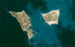
| Chatham Islands: Updated Airports, Landclass, Water Data, and Flight Plans |
|
Images related to this file:
File Description:
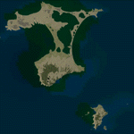
This project significantly updates New Zealand's Chatham Islands and includes more accurate coastlines, lakes, road and river data, as well as corrected landclass and a fully updated Chatham Islands/Tuuta Airport (NZCI). Napier (NZNR) aprons and terminal are also updated to more closely reflect the actual airport and accommodate Air Chathams, and the Pitt Island Airstrip (NZPI) is added to FSX. All updates were done in a manner which carefully aligned airport data with current satellite imagery. These airports are served by Air Chathams. Scenery was created using Airport Design Editor X v1.47.07, SBuilderX 3.13, and the FSX Object Placement Tool. Scenery objects were added and modified from stock FSX scenery to resemble as closely as possible the actual airports.
| Filename: | Chatham_Islands_Updated_Airports_Landclass_Water_D.zip |
| License: | Freeware |
| Added: | 8th July 2011, 21:44:02 |
| Downloads: | 1,674 |
| Author: | Carlyle Sharpe |
| Size: | 17.78 MB |
| Category: Flight Simulator 2004 - Scenery | |
| FHSH - St. Helena Island **UPDATE ** |
|
Images related to this file:
File Description:

These files update the "fs9_st_helena_island.zip" project to its current, real-world status. They update the St. Helena (FHSH) localizer from the previous 15-degree offset to the present 5-degree offset, remove the glideslope from the ILS, and update the naming of the approach plates.
| Filename: | FHSH__St_Helena_Island_UPDATE_.zip |
| License: | Freeware |
| Added: | 22nd May 2016, 14:33:55 |
| Downloads: | 1,158 |
| Author: | Carlyle Sharpe |
| Size: | 20.37 KB |
| Category: Flight Simulator X - Scenery | |
| Honduras Islands v3 |
|
Images related to this file:
File Description:

Version 3 includes all previous patches and updates. This version also restructures the file system to be fully compatible with the ORBX "FTX Global openLC North America" product as well as adding functionality for default FSX users. Additionally, water class scenery is updated to appear more realistic, MHRO is updated to reflect the newly expanded apron, and SRTMGL1 (30m) mesh is included. All landclass polygons and coastlines were meticulously hand-drawn directly from satellite imagery to provide the most detailed and accurate scenery available for this region.
This project rebuilds the islands of Roatán, Barbareta, Guanaja, and Utila, and adds Cayos Cochinos and the numerous cays associated with the "Islas de la Bahia" (Islands of the Bay). Roatán (MHRO), Guanaja (GJAJ/MHNJ) and Puerto Lempira (MHPL) are completely overhauled and positioning is corrected. New and fully functioning AI airports are added for Utila (MHUT), Fort Cay (MHFC) and Cochino Pequeño (MHCP) of the Cayos Cochinos chain, and La Ceiba (MHLC) is modified to accommodate more AI traffic. Accurate coastlines, lakes, road and river data, as well as corrected landclass are provided based on the latest available satellite imagery. GA flight plans are provided to add or enhance service to the smaller islands. Updates were created or rebuilt in a manner which carefully aligned airport data with current satellite imagery, when available. Scenery was created using Airport Design Editor X v1.70.6042, SBuilderX 3.13, and the FSX Object Placement Tool. Scenery objects were added and modified from stock FSX scenery to resemble as closely as possible the actual airports.
| Filename: | Honduras_Islands_v3.zip |
| License: | Freeware |
| Added: | 23rd December 2016, 08:17:26 |
| Downloads: | 1,605 |
| Author: | Carlyle Sharpe |
| Size: | 17.35 MB |
| Category: Flight Simulator X - Scenery | |
| Los Roques Archipelago and Airports |
|
Images related to this file:
File Description:
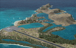
This project rebuilds Venezuela's Los Roques archipelago, adds the Gran Roque (SVRS) and Dos Mosquises (SVDM) airports, and includes AI flight plans, boat traffic, and a custom terrain mesh for Gran Roque. Accurate coastlines and lakes, as well as corrected landclass and waterclass are provided based on the latest available satellite imagery. Although current satellite imagery for this region only exists in relatively low resolution, an abundance of aerial photography was used to add custom features to Gran Roque and Dos Mosquises. Updates were created or rebuilt in a manner which carefully aligned airport data with current satellite imagery, when available. Scenery was created using Airport Design Editor X v1.50.4402, SBuilderX 3.13, and the FSX Object Placement Tool. Scenery objects were added and modified from stock FSX scenery to resemble as closely as possible the actual airports. Thank you to John Hinson and Tiago Besciak for granting permission to adapt their AI flight plans to realistically populate (SVRS) Gran Roque.
| Filename: | Los_Roques_Archipelago_and_Airports.zip |
| License: | Freeware |
| Added: | 27th July 2013, 02:34:10 |
| Downloads: | 1,387 |
| Author: | Carlyle Sharpe |
| Size: | 7.66 MB |
| Category: Flight Simulator X - Scenery | |
| Goma Intl (FZNA) DRC and Gisenyi (HRYG) Rwanda |
|
Images related to this file:
File Description:
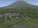
This project includes the neighboring Goma Intl (FZNA) and Gisenyi (HRYG) airports. After Goma's only runway was severely damaged by the eruption of Mount Nyiragongo in 2002, the runway, originally 3000m long, was reduced to 1800m of serviceable pavement after lava flowed onto the northern part runway and through the city center. In 2013, German NGO Welthungerhilfe ("World Hunger Aid") signed a contract to rehabilitate 500m of runway damaged by the lava flow. Goma resumed scheduled international flights in 2015, and this project reflects the airport as of March 2016, with runway 18/36 renumbered to 17/35. SRTMGL1 (30m) mesh brings the volcanoes in the area into much greater detail. This scenery is complimented by the Kigali Intl (HRYR) scenery (FSX_HRYR_Kigali_2016.zip).
Updates were created or rebuilt in a manner which carefully aligns airport data with current satellite imagery. Scenery was created using Airport Design Editor X v1.70.6042, SBuilderX 3.13, and the FSX Object Placement Tool. Scenery objects were added and modified from stock FSX scenery to resemble as closely as possible the actual airports. The FSX apron lights included are from the set created by Jim Dhaenens.
| Filename: | Goma_Intl_FZNA_DRC_and_Gisenyi_HRYG_Rwanda.zip |
| License: | Freeware |
| Added: | 4th August 2016, 21:11:20 |
| Downloads: | 2,276 |
| Author: | Carlyle Sharpe |
| Size: | 5.25 MB |
| Category: Flight Simulator X - Scenery | |
| SEGU - Jose Joaquin de Olmedo International Airport - Guayaquil, Ecuador |
|
Images related to this file:
File Description:
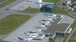
Building upon Menno Robert's original SEGU airport as a starting point, this project updates the coordinates of the airport, adds more visual detail, further expands aprons and the new terminal, and optimizes the scenery to fit seamlessly with FTX Global/Vector. This airport should also be fully functional in all FSX configurations. The airport is updated to reflect current satellite imagery and positioning. Scenery was created using Airport Design Editor X v1.61.5298, SBuilderX 3.13, and the FSX Object Placement Tool. Scenery objects were added and modified from stock FSX scenery to resemble as closely as possible the actual airport.
Thank you to Menno Robert for granting permission to edit his original SEGU file.
| Filename: | SEGU__Jose_Joaquin_de_Olmedo_International_Airport.zip |
| License: | Freeware |
| Added: | 4th July 2015, 18:22:13 |
| Downloads: | 4,204 |
| Author: | Carlyle Sharpe |
| Size: | 2.79 MB |
| Category: Flight Simulator X - Scenery | |
| Helgoland and Airports |
|
Images related to this file:
File Description:
This project rebuilds Germany's Helgoland, upgrades the Duene (EDXH) and Wangerooge (EDWG) airports to be fully AI compliant, and includes AI flight plans between EDXH and EDWG to bring the airports to life. Accurate shorelines, as well as corrected landclass and waterclass, are provided. Updates were created or rebuilt in a manner which carefully aligned airport data with current satellite imagery. Scenery was created using Airport Design Editor X v1.61.5273, SBuilderX 3.13, and the FSX Object Placement Tool. Scenery objects were added and modified from stock FSX scenery to resemble as closely as possible the actual airports.
| Filename: | Helgoland_and_Airports.zip |
| License: | Freeware |
| Added: | 16th June 2014, 06:02:08 |
| Downloads: | 2,825 |
| Author: | Carlyle Sharpe |
| Size: | 1.65 MB |
| Category: Flight Simulator X - Scenery | |
| MMTJ - Gen Abelardo L Rodriguez Intl - Tijuana, Mexico ----- KSDM - Brown Mun - San Diego, California - USA |
|
Images related to this file:
File Description:
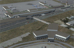
This scenery adds the new Cross Border Xpress (CBX) terminal to MMTJ, which opened on December 9, 2015, making it the first airport in the world to have connecting terminals in two different countries. All of MMTJ is also updated to reflect the most current airport layout. The neighboring KSDM is also completely updated and included in this scenery package. This scenery is optimized to fit seamlessly with FTX Global/Vector and also includes an optional CVX file which adds roads for default FSX users. All elements of both airports were traced directly from current satellite imagery and updated to reflect current satellite positioning. Scenery was created using Airport Design Editor X v1.61.5298, SBuilderX 3.13, and the FSX Object Placement Tool. Scenery objects were added and modified from stock FSX scenery to resemble as closely as possible the actual airports. The FSX apron lights included are from the set created by Jim Dhaenens.
| Filename: | MMTJ__Gen_Abelardo_L_Rodriguez_Intl__Tijuana_Mexic.zip |
| License: | Freeware |
| Added: | 3rd January 2016, 12:58:36 |
| Downloads: | 2,669 |
| Author: | Carlyle Sharpe |
| Size: | 3.58 MB |
| Category: Flight Simulator X - Scenery | |
| SCIP - Isla de Pascua & Mataveri Intl - Easter Island |
|
Images related to this file:
File Description:
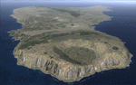
This project rebuilds Easter Island / Isla de Pascua. Mataveri Intl (SCIP) is completely overhauled, and all airport objects are aligned from satellite imagery. Landclass polygons and coastlines were meticulously hand-drawn directly from satellite imagery to provide the most detailed and accurate scenery available for this region. AI road and boat traffic is activated for the region. Accurate coastlines and road data, as well as corrected land and waterclass are provided based on the latest available satellite imagery. GA flights use default aircraft and include an option to add Chilean Air Force planes around the island. Numerous Moai (Easter Island heads) have been placed around the island according to satellite imagery. Scenery was created using Airport Design Editor X v1.61.5298, SBuilderX 3.13, and the FSX Object Placement Tool. Scenery objects were added and modified from stock FSX scenery to resemble as closely as possible the actual airports. The FSX apron lights included are from the terrific set created by Jim Dhaenens.
| Filename: | SCIP__Isla_de_Pascua__Mataveri_Intl___Easter_Islan.zip |
| License: | Freeware |
| Added: | 12th July 2014, 08:17:55 |
| Downloads: | 5,710 |
| Author: | Carlyle Sharpe |
| Size: | 5.33 MB |
© 2001-2026 AVSIM Online
All Rights Reserved
Privacy Policy |