
Where Flight Simulation Enthusiasts Gather from Around the World!
AVSIM Library - Search Results

| Category: Flight Simulator X - Scenery | |
| Bhutan Airports Tower Information |

|
File Description:
These files update the tower information for the "Bhutan Airports and Paro Valley" scenery and require the "bhutan_airports_and_paro_valley.zip" file. Unzip the "bhutan_airports_twr_info.zip" file and copy/replace the files in the "Bhutan_Airports_and_Paro_Valley\scenery" folder with the new files.
| Filename: | Bhutan_Airports_Tower_Information.zip |
| License: | Freeware |
| Added: | 19th January 2015, 18:54:22 |
| Downloads: | 3,031 |
| Author: | Carlyle Sharpe |
| Size: | 3.62 KB |
| Category: Flight Simulator X - Scenery | |
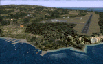
| Rodrigues Island, Mauritius ** UPDATE ** |
|
Images related to this file:
File Description:
This update adds numerous visual details to the area around the Rodrigues Island (FIMR) airport as well as the addition of more roads to the island. Namely, the approach lights to runway 12 are corrected to appear on pylons and at runway elevation. This update requires "rodrigues_island.zip".
| Filename: | Rodrigues_Island_Mauritius__UPDATE_.zip |
| License: | Freeware |
| Added: | 8th December 2015, 15:44:47 |
| Downloads: | 1,094 |
| Author: | Carlyle Sharpe |
| Size: | 408.61 KB |
| Category: Flight Simulator X - Scenery | |
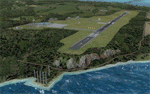
| Rodrigues Island, Mauritius |
|
Images related to this file:
File Description:
This project rebuilds Rodrigues Island, Mauritius. Deenesh Suddoo's Sir Gaetan Duval Airport (FIMR) is included with permission from the author, and is updated slightly for alignment and full AI traffic compatibility. Landclass polygons and coastlines were hand-drawn directly from satellite imagery to provide the most detailed and accurate scenery currently available for this island. AI road and boat traffic is activated for the region. Accurate coastlines and road data, as well as corrected land and waterclass are provided based on the latest available satellite imagery. Scenery was created using Airport Design Editor X v1.61.5298, SBuilderX 3.13, and the FSX Object Placement Tool. Scenery objects were added and modified from stock FSX scenery to resemble as closely as possible the real-life images.
| Filename: | Rodrigues_Island_Mauritius.zip |
| License: | Freeware |
| Added: | 1st November 2014, 00:52:44 |
| Downloads: | 2,173 |
| Author: | Carlyle Sharpe |
| Size: | 2.63 MB |
| Category: Flight Simulator 2004 - Scenery | |
| 'Classic' Water Reflection |
|
File Description:
For those of you that miss the FS2002 water reflections, these are optimized sun and moon reflection textures for FS2004. The new files are a quarter the size of the original files, with no visual degradation (that I could see) and improved performance.
These should work with older video cards (non-DX9) as well and look great with either "High" or "Low" Water Effects enabled. They look particularly good when combined with the OceanFX 2 package (with OCEANSFX.ZIP and OCEANSTX.ZIP).
| Filename: | Classic_Water_Reflection.zip |
| License: | Freeware |
| Added: | 27th October 2003, 16:53:50 |
| Downloads: | 14,847 |
| Author: | Carlyle Sharpe |
| Size: | 645.85 KB |
| Category: Flight Simulator X - Scenery | |
| FHSH - St. Helena Island **UPDATE ** |
|
Images related to this file:
File Description:
These files update the "FSX_St_Helena_Ascension_Tristan-da-Cunha.zip" project to its current, real-world status. They update the St. Helena (FHSH) localizer from the previous 15-degree offset to the present 5-degree offset, remove the glideslope from the ILS, and update the naming of the approach plates.
| Filename: | FHSH__St_Helena_Island_UPDATE_.zip |
| License: | Freeware |
| Added: | 22nd May 2016, 14:32:17 |
| Downloads: | 3,276 |
| Author: | Carlyle Sharpe |
| Size: | 274.34 KB |
| Category: Flight Simulator X - Scenery | |
| VTBS - Suvarnabhumi Intl - Bangkok, Thailand **Custom Airport Background** |
|
Images related to this file:
File Description:
Provided is an airport background for Ray Smith's VTBS - Suvarnabhumi Intl - Bangkok, Thailand airport. This custom background can be easily added without disturbing the original airport, and it will also resolve water canal scenery conflicts for FTX Vector users. This background should work for all users, but it is optimized to take advantage of FTX Vector, and the airport road/highway system is now connected with all of the FTX Vector roads. Scenery was created using SBuilderX 3.13 and the FSX Object Placement Tool.
This scenery requires Ray Smith's VTBS - Suvarnabhumi Intl "fsx_vtbs_v1.5_rs.zip".
| Filename: | VTBS__Suvarnabhumi_Intl__Bangkok_Thailand_Custom_A.zip |
| License: | Freeware |
| Added: | 5th January 2015, 00:31:57 |
| Downloads: | 5,444 |
| Author: | Carlyle Sharpe |
| Size: | 1.32 MB |
| Category: Flight Simulator X - Scenery | |
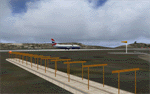
| FIMP - Sir Seewoosagur Ramgoolam Intl - Mauritius - New Terminal & Airport Layout ** UPDATE ** |
|
Images related to this file:
File Description:

This update for the new terminal and airport layout at FIMP (Mauritius_FSX_New_Terminal.zip) adds the airport perimeter/service road, refines taxi sign information and layout, makes a minor fix to apron lights, improves traffic movement for airport vehicles, patches the "lake in hole" for default FSX users, provides an optional GA traffic file for FIMP, and adds numerous visual updates. The update was created using Airport Design Editor X v1.61.5298 and SBuilderX 3.13.
| Filename: | FIMP__Sir_Seewoosagur_Ramgoolam_Intl__Mauritius__N.zip |
| License: | Freeware |
| Added: | 13th July 2015, 15:18:19 |
| Downloads: | 5,829 |
| Author: | Carlyle Sharpe |
| Size: | 859.53 KB |
| Category: Flight Simulator X - Scenery | |
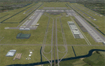
| Houston Hobby KHOU - New Terminal |
|
Images related to this file:
File Description:
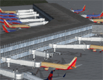
Removes the old terminal and creates the new Houston Hobby terminal using stock FSX textures and the FSX object tool. Terminal and adjacent taxiways were placed and adjusted based on current satellite imagery. New AFCAD was created using FSX Planner with the help of SBuilderX 3.13.
| Filename: | Houston_Hobby_KHOU__New_Terminal.zip |
| License: | Freeware |
| Added: | 7th July 2010, 23:19:54 |
| Downloads: | 2,576 |
| Author: | Carlyle Sharpe |
| Size: | 111.15 KB |
| Category: Flight Simulator X - Scenery | |
| Chatham Islands for Vector Land Class New Zealand |
|
Images related to this file:
File Description:
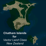
This project is a modified version of the Chatham_Islands.zip project which allows my landclass and airports to work seamlessly with the free Chatham Islands scenery available from Vector Land Class New Zealand. This package allows the user to switch back and forth easily between the different scenery combinations and also provides standalone Chatham and Pitt Island airports which can be used with the Vector Land Class (VLC) scenery on its own. It also allows the user to take advantage of the 15m terrain mesh and added water detail that comes with the VLC scenery. A modified Pitt Island AI runway is also included that is compatible with the 15m mesh. Chatham Islands/Tuuta Airport (NZCI), Napier (NZNR), and the Pitt Island Airstrip (NZPI) are included here. Scenery was created using Airport Design Editor X v1.47.07, SBuilderX 3.13, and the FSX Object Placement Tool. Scenery objects were added and modified from stock FSX scenery to resemble as closely as possible the actual airports.
| Filename: | Chatham_Islands_for_Vector_Land_Class_New_Zealand.zip |
| License: | Freeware |
| Added: | 15th July 2011, 21:54:43 |
| Downloads: | 931 |
| Author: | Carlyle Sharpe |
| Size: | 3.78 MB |
| Category: Flight Simulator X - Scenery | |
| Chatham Islands: Updated Airports, Landclass, Water Data, and Flight Plans |
|
Images related to this file:
File Description:
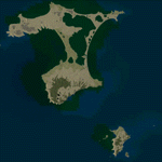
This project significantly updates New Zealand's Chatham Islands and includes more accurate coastlines, lakes, road and river data, as well as corrected landclass and a fully updated Chatham Islands/Tuuta Airport (NZCI). Napier (NZNR) aprons and terminal are also updated to more closely reflect the actual airport and accommodate Air Chathams, and the Pitt Island Airstrip (NZPI) is added to FSX. All updates were done in a manner which carefully aligned airport data with current satellite imagery. These airports are served by Air Chathams. Scenery was created using Airport Design Editor X v1.47.07, SBuilderX 3.13, and the FSX Object Placement Tool. Scenery objects were added and modified from stock FSX scenery to resemble as closely as possible the actual airports.
| Filename: | Chatham_Islands_Updated_Airports_Landclass_Water_D.zip |
| License: | Freeware |
| Added: | 8th July 2011, 21:44:02 |
| Downloads: | 1,674 |
| Author: | Carlyle Sharpe |
| Size: | 17.78 MB |
© 2001-2026 AVSIM Online
All Rights Reserved
Privacy Policy |