
Where Flight Simulation Enthusiasts Gather from Around the World!
AVSIM Library - Search Results

| Category: Flight Simulator 2004 - Scenery | |
| Colorado Lakes Project I |

|
File Description:
These files ADD 15 highly detailed lakes to Colorado. Although these lakes are specifically designed to show off their photo realistic detail when used in combination with 38.2m mesh, they work equally as well with the default mesh. All lake information was derived from detailed map data.
Included lakes are: the Antero, Eleven Mile, Spinney, Paonia, Lemon, Vallecito, Ruedi and Taylor Reservoirs, Cheesman Lake, Lake Grant, Peanut Lake, Meridian Lake, Nicholson Lake, Lake Irwin, and McPhee Reservoir, which is the second largest reservoir in the state.
| Filename: | Colorado_Lakes_Project_I.zip |
| License: | Freeware |
| Added: | 8th February 2004, 23:33:51 |
| Downloads: | 5,276 |
| Author: | Carlyle Sharpe |
| Size: | 253.36 KB |
| Category: Flight Simulator 2004 - Scenery | |
| Colorado Lakes Project IV |
|
File Description:
This project features the lakes of North Central Colorado, replaces all of the prominent reservoirs and lakes of the region (Dillon, Green Mountain, Granby, Williams Fork, and more), and adds over 500 highly detailed lakes to Colorado. They fit seamlessly with my "Colorado Lakes Project III" (colorado_lakes_project_3.zip), "Colorado Lakes Project II" (colorado_lakes_project_2.zip) and "Colorado Lakes Project I" (colorado_lakes_project_1.zip) lakes.
These lakes are specifically designed to show off their photo realistic detail when used in combination with "FSGenesis-The Rockies 38.2m Terrain Mesh-Colorado" available as "fsg_dem38m_usrk_co.zip" at avsim.com, or comparable mesh. The free FSGenesis US National Landclass Project Beta 6 also adds beautifully to the landscape. These lakes work equally as well with the default mesh.
All lake information was projected from satellite imagery and compiled with a beta version of Jim Keir's "Slartibartfast" utility.
| Filename: | Colorado_Lakes_Project_IV.zip |
| License: | Freeware |
| Added: | 10th June 2004, 04:27:10 |
| Downloads: | 4,829 |
| Author: | Carlyle Sharpe |
| Size: | 743.4 KB |
| Category: Flight Simulator 2004 - Scenery | |
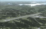
| Branson Airport KBBG--New Airport, Scenery, and Flight Plans |
|
Images related to this file:
File Description:

This project adds a new Branson Airport KBBG (Missouri) to FS 2004, which opened in May 2009, and is a privately developed commercial airport. The construction of the airport, which involved the flattening of several Ozark Mountains, is claimed to be the largest earthmoving project in Missouri history. As a result, the airport actually sits on a manmade plateau, surrounded by rolling hills. The airport uses the ICAO identifier BBG, however, the airlines use the IATA code BKG. The airport is served by AirTran, Frontier, and ExpressJet (Branson AirExpress), and is located in hilly terrain. Aircraft equipped with a terrain avoidance warning system may experience system activation on final approach. AFCAD created using Airport Design Editor 9 v1.47.07, and the hilltops were cleared and flattened and roads were added using SBuilder 2.05 revision 06. The terminal and hangar were added and modified from within Airport Design Editor 9. This airport is based on my more detailed FSX version, Branson_Airport_Project.zip.
| Filename: | Branson_Airport_KBBGNew_Airport_Scenery_and_Flight.zip |
| License: | Freeware |
| Added: | 16th August 2010, 20:50:16 |
| Downloads: | 1,731 |
| Author: | Carlyle Sharpe |
| Size: | 3.23 MB |
| Category: Flight Simulator X - AFCAD Files | |
| Minneapolis/St. Paul (KMSP) Regional Gates and Jetways Update |
|
File Description:
Update to default KMSP for FSX which adds all regional gates and jetways as well as assigning parking at other gates.
| Filename: | MinneapolisSt_Paul_KMSP_Regional_Gates_and_Jetways.zip |
| License: | Freeware |
| Added: | 13th January 2007, 23:14:20 |
| Downloads: | 2,176 |
| Author: | Carlyle Sharpe |
| Size: | 24.01 KB |
| Category: Flight Simulator X - AFCAD Files | |
| Houston Hobby - Fix |
|
File Description:
Houston Hobby AFCAD Fix for New Terminal - Fixes bug from the default file that prevented traffic from properly accessing runway 12R for takeoff. For use with the new terminal scenery houston_hobby.zip.
| Filename: | Houston_Hobby__Fix.zip |
| License: | Freeware |
| Added: | 10th July 2010, 20:21:15 |
| Downloads: | 1,386 |
| Author: | Carlyle Sharpe |
| Size: | 16.94 KB |
| Category: Flight Simulator X - Scenery | |
| Branson Airport KBBG--New Airport, Scenery, and Flight Plans |
|
Images related to this file:
File Description:
This project adds a new, detailed Branson Airport KBBG (Missouri) to FSX, which opened in May 2009, and is a privately developed commercial airport. The construction of the airport, which involved the flattening of several Ozark Mountains, is claimed to be the largest earthmoving project in Missouri history. As a result, the airport actually sits on a manmade plateau, surrounded by rolling hills. The airport uses the ICAO identifier BBG, however, the airlines use the IATA code BKG. The airport is served by AirTran, Frontier, and ExpressJet (Branson AirExpress), and is located in hilly terrain. Aircraft equipped with a terrain avoidance warning system may experience system activation on final approach. Birds are in the vicinity of the airport. AFCAD with sloping terrain created using Airport Design Editor X v1.47.07, and the hilltops were cleared and flattened and roads were added using SBuilderX 3.13. The terminal, hangar, FBO, and cars were added and modified from stock FSX scenery, using the FSX Object Tool, to resemble as closely as possible the actual airport.
| Filename: | Branson_Airport_KBBGNew_Airport_Scenery_and_Flight.zip |
| License: | Freeware |
| Added: | 5th August 2010, 01:08:33 |
| Downloads: | 2,003 |
| Author: | Carlyle Sharpe |
| Size: | 6.02 MB |
| Category: Flight Simulator 2004 - AFCAD Files | |
| Branson Airport KBBG for FS9--ILS Fix/Added Approaches |
|
File Description:
Modified AFCAD for Branson_airport_project_FS9.zip that includes all 3 of the published approaches, terminal waypoints, and missed approach code, and corrects the magnetic deviation of the ILS. Thank you to Bruce Nicholson for providing the updated code. Simply overwrite the old AFCAD with 6_KBBG_Branson_Airport_AFCAD_ADE9.BGL.
| Filename: | Branson_Airport_KBBG_for_FS9ILS_FixAdded_Approache.zip |
| License: | Freeware |
| Added: | 22nd August 2010, 16:22:38 |
| Downloads: | 879 |
| Author: | Carlyle Sharpe |
| Size: | 3.88 KB |
| Category: Flight Simulator X - AFCAD Files | |
| Branson Airport KBBG for FSX--ILS Fix/Added Approaches |
|
File Description:
Modified AFCAD for Branson_airport_project.zip that includes all 3 of the published approaches, terminal waypoints, and missed approach code, and corrects the magnetic deviation of the ILS. Thank you to Bruce Nicholson for providing the updated code. Simply overwrite the old AFCAD with 3_KBBG_Branson_Airport_FSX_AFCAD_ADEX.BGL.
| Filename: | Branson_Airport_KBBG_for_FSXILS_FixAdded_Approache.zip |
| License: | Freeware |
| Added: | 22nd August 2010, 16:23:50 |
| Downloads: | 1,186 |
| Author: | Carlyle Sharpe |
| Size: | 4.29 KB |
| Category: Flight Simulator 2004 - Aircraft Repaints, Textures and Modifications | |
| Miracle on the Hudson |
|
File Description:
This will make the Airbus 320-200 "floatable", so that one can retrace the flight path of flight 1549 and have your own "Miracle on the Hudson."
| Filename: | Miracle_on_the_Hudson.zip |
| License: | Freeware |
| Added: | 20th January 2009, 22:20:50 |
| Downloads: | 761 |
| Author: | Carlyle Sharpe |
| Size: | 85.85 KB |
| Category: Flight Simulator X - Aircraft Repaints, Textures and Modifications | |
| Miracle on the Hudson |
|
File Description:
This will make the FSX default Airbus A321 "floatable", so that one can retrace the flight path of flight 1549 and have your own "Miracle on the Hudson."
| Filename: | Miracle_on_the_Hudson.zip |
| License: | Freeware |
| Added: | 20th January 2009, 22:21:09 |
| Downloads: | 1,369 |
| Author: | Carlyle Sharpe |
| Size: | 305.51 KB |
© 2001-2026 AVSIM Online
All Rights Reserved
Privacy Policy |