
Where Flight Simulation Enthusiasts Gather from Around the World!
AVSIM Library - Search Results

| Category: Flight Simulator 2004 - Aircraft Repaints, Textures and Modifications | |
| Ultimate Wing Views for the Dreamwings Dash 8-100 Aircraft |

|
File Description:
' Ultimate Wing Views ' for the Dreamwings Dash 8 100 Series Aircraft! There are actually SIX (6) Wing Views, ranging from Behind the wing, center wing, and in front of the wing on both sides of the aircraft. All of these wing views have been extensively fine-tuned to provide the most realistic experience! I also have many other wing - views available in the AVSIM Library, just search for ' Ultimate Wing Views ' for the aircraft you need them for. Thanks and Enjoy!
| Filename: | Ultimate_Wing_Views__for_the_Dreamwings_Dash_8100_.zip |
| License: | Freeware |
| Added: | 22nd August 2006, 15:32:59 |
| Downloads: | 688 |
| Author: | Brian Kolbuch |
| Size: | 178.42 KB |
| Category: Flight Simulator X - Scenery | |
| USCG Air Station Sitka PASI Scenery Package with AI Aircraft |
|
Images related to this file:
File Description:

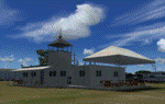
Thanks to Airport Design Editor(ADE), Military AI Works (MAIW) scenery and aircraft, along with AI Flight Planner3 (AIFP3), I did my best to re-create USCG Air Station Sitka for FSX. Creating this airport scenery (along with Kodiak PADQ) was my first attempt at a BIG (for me) scenery project in ADE, but thanks to MAIW and their Global Scenery Library Objects, I think I've succeeded in re-creating the airbase. You'll need to go to MAIW's website and download that "Global Scenery" file for any of this to work, so I've copied that website link below (in STEP 1). I also added Sitka markings to all the AI helicopters for added realism.
And just for fun, I placed a USCG Cutter and a "fishing boat in distress" (complete with green smoke) out in the harbor as a "Practice Rescue Scenario". The Cutter has a "hard deck" to land on and I've also illuminated both it and the Fishing boat for DUSK and NIGHT practice.
*SPECIAL NOTE* THE AI C-130 in the pictures is from my Kodiak scenery package, there are only Helicopters based at Sitka...but I have it "fly in" from my Kodiak scenery package. So if you're interested in that, you can find the "USGC Air Station Kodiak AK PADQ Scenery Package with AI Aircraft" on AVSIM as well.
| Filename: | USCG_Air_Station_Sitka_PASI_Scenery_Package_with_A.zip |
| License: | Freeware |
| Added: | 31st January 2021, 06:43:13 |
| Downloads: | 1,077 |
| Author: | Daniel W Gregory |
| Size: | 16.58 MB |
| Category: Flight Simulator X - Aircraft Repaints, Textures and Modifications | |
| Thomas Ruth A330-200 PW Virgin Atlantic livery (no aircraft) |
|
Images related to this file:
File Description:
Virgin Atlantic 'Scarlett o'Hara' livery for Thomas Ruth A330-200. This is one of four aircrafts that Virgin buyed to Air Berlin. Must be used with the PW (Pratt & Whitney) model.
| Filename: | Thomas_Ruth_A330200_PW_Virgin_Atlantic_livery_no_a.zip |
| License: | Freeware |
| Added: | 14th May 2022, 15:28:35 |
| Downloads: | 100 |
| Author: | Antonio Diaz Cayuela |
| Size: | 3.53 MB |
| Category: Microsoft Flight Simulator (2020) - Miscellaneous Files | |
| FS2024 Integrated Flight Operations Guide – SimBrief • PMDG/Native Aircraft • FSHud |
|
File Description:
FS2024 Integrated Flight Operations Guide – SimBrief • PMDG/Native • FSHudA concise, airline‑style workflow for Microsoft Flight Simulator 2024 integrating SimBrief flight planning, PMDG or Native aircraft FMC setup, and FSHud ATC/traffic management. This guide provides a clear, repeatable, version‑safe process designed to eliminate common setup errors and maintain proper synchronization between planning, aircraft systems, and ATC. Fully original text with no redistributed or copyrighted material.Features:
• Gate‑to‑gate workflow
• SimBrief‑first planning logic
• FMC setup for PMDG/Native aircraft
• FSHud integration
• Text‑only, version‑safe formatFormat: PDF (locked to prevent modification)
Author: George (Gelomare)
License: Freeware – Limited Distribution-- No Commercial Usage Allowed
| Filename: | FS2024_Integrated_Flight_Operations_Guide__SimBrie.zip |
| License: | Freeware, limited distribution |
| Added: | 16th May 2026, 20:51:33 |
| Downloads: | 73 |
| Author: | George L. Williams |
| Size: | 91.42 KB |
| Category: Flight Simulator X - Scenery | |
| Kopaida Airfield, Greece |
|
Images related to this file:
File Description:
"Kopaida" airfield is a grass private strip, 105km NW of Athens located in the Kopaida drained lake plains between the towns of Aliartos, Kastro and Orchomenos and west of Yliki lake. It is a pure general aviation field and a hub of activity for numerous sport planes, gliders and motor gliders. The field includes a small tower and canteen and several owners of GA aircraft house them in the roomy hangar and also keep a mobile home or RV in the premises. The scenery includes a region and landclass bgl that will force a large area of the Kopaida plains around the airport to display US field textures. This was done because the US fields textures are rectangular and aligned N-E and W-E, in a similar way as the actual fields around the airport. A small photo background is used for the airfield itself. The photo background includes seasonal variations with slight colour variances as well as some autogen trees and shrubs. Custom GA traffic is also included. There is one trike doing circuits and TnGs and a Turbo Porter flying the circuit, simulating a skydiving sortie. The Turbo Porter used is the great freeware one created by Tim (Piglet) Conrad. I have also included a repaint for the F-GHVH, the Porter used by the GFFC, which sports a flashy "Alien" graffiti scheme.
*For FSX SP2 / Acceleration / P3D v1.00*
| Filename: | Kopaida_Airfield_Greece.zip |
| License: | Freeware |
| Added: | 3rd June 2014, 21:23:30 |
| Downloads: | 1,471 |
| Author: | Vassilios Dimoulas |
| Size: | 25.01 MB |
| Category: Flight Simulator 2004 - Utilities | |
| CrewSounds2 2010 |
|
File Description:
You know the kind of situation. You sit in front of your computer, flying around, but something is missing. Exactly, you're alone (usually). While on normal flights, you are sitting with several people in a plane. But as a home pilot, you are sitting alone in front of the computer. With CrewSounds2 2010 it will change a little. You are still sitting alone in front of the computer, but at least you can hear in the background a little something.
It should work also with FSX.
| Filename: | CrewSounds2_2010.zip |
| License: | Freeware |
| Added: | 16th December 2010, 23:26:52 |
| Downloads: | 2,432 |
| Author: | Oliver Strauss |
| Size: | 10.29 MB |
| Category: Prepar3D V5 - Scenery | |
| Giallo Airport HLGL |
|
Images related to this file:
File Description:

Giallo Airport located in Wahat district approximately 40 km south of Giallo city and it is owned by the Waha Oil Company.
There are active flights between other oil fields like Waha, Nafoora oil field and Samah Oil field And to main airports (Tripoli,Benghazi and Labraq) by Air Libya and Petro Air.
____________________________________________________________________________
Features:
- Super-accurate layout and precise marking according to the latest satellite images.
- Photo background blends perfectly with ORBX Global.
- Hight detailed terminal and buildings ,high quality custom ground textures.
- Dynamic Apron Lights.
| Filename: | Giallo__Airport__HLGL.zip |
| License: | Freeware |
| Added: | 25th May 2022, 23:19:40 |
| Downloads: | 107 |
| Author: | Hamza Swaid |
| Size: | 82.54 MB |
| Category: Flight Simulator X - Scenery | |
| Flatval ENFA Froya |
|
Images related to this file:
File Description:
This airfield is located on the Norwegian island of Froya and currently closed. Its territory is now used by a local motor club and for various racing events. Parking spaces and fictional NDB (338.0) were added to make this scenery functional.
Flatval is very accurate according to the latest satellite images. Seasonal photo background included and blends perfectly into ORBX OpenLC EU. Surrounding landclass was reworked to better match real Froya.
Made for P3Dv3, should work in FSX:SE, FSX and P3Dv4. Made by Dmitriy Kozyrev.
| Filename: | Flatval_ENFA_Froya.zip |
| License: | Freeware |
| Added: | 25th August 2017, 02:50:07 |
| Downloads: | 664 |
| Author: | Dmitriy Kozyrev |
| Size: | 5.59 MB |
| Category: Flight Simulator 2004 - Panels | |
| Convair CV-580 |
|
File Description:
2D panel for the Convair CV-580 twin-engine prop airliner. It uses mainly FS9 default gauges; the extra gauges used are included. Realistic looking; bitmap of real aircraft's cockpit was used as background. Also makes use of FSACARS and ServInfo gauges if you make use of those fine additions for online flying. Fully IFR capible (NAV2, DME, etc). Works well with other 2-engine props other than the Convair. Tested only with Microsoft Flight Simulator 2004 - A Century of Flight. Have a good flight!
| Filename: | Convair_CV580.zip |
| License: | Freeware |
| Added: | 15th February 2005, 04:52:17 |
| Downloads: | 3,179 |
| Author: | Timothy Suckow |
| Size: | 2.52 MB |
| Category: Flight Simulator 2004 - Scenery | |
| Ivujivik CYIK in Hudson Bay, Quebec, Canada |
|
Images related to this file:
File Description:
Ivujivik is a village of 350 or so inhabitants at N62 25 W78 on the northeastern corner of Hudson Bay. The village does not feature in FS9 but is included in this scenery with approximately the right shape (the coast, even with UT, is not exactly right) so just think of it as a hand-made auto-generated village which gives the airfield a reason. The runway is 3,500 feet of gravel 100 feet wide, which should be enough. I also added the roads, deleted the stock airfield background and added a new background, plus of course there is the scenery file and the AFCAD and AI. You may note that the terminal has the elevation written on the sign as 126', while on the winter photo it is written on the older & bigger sign as 130'. I thought this is because satellite radar has fixed the elevations of all airfields more accurately than before, as Rockcliffe too has gone from 192' to 188'; the alternative explanation is that global warming has raised sea level by 4'. Wow! That's a thought. I presume the new sign was made smaller as a cost saving.
| Filename: | Ivujivik_CYIK_in_Hudson_Bay_Quebec_Canada.zip |
| License: | Freeware, limited distribution |
| Added: | 31st October 2010, 07:41:20 |
| Downloads: | 457 |
| Author: | Roger Wensley |
| Size: | 2.07 MB |
© 2001-2026 AVSIM Online
All Rights Reserved
Privacy Policy |