
Where Flight Simulation Enthusiasts Gather from Around the World!
AVSIM Library - Search Results

| Category: Flight Simulator X - Aircraft Repaints, Textures and Modifications | |
| De Havilland Canada DHC-2 Beaver (VH-AAO) |

|
Images related to this file:
File Description:
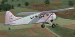
This folder contains a repaint for the Milviz DHC-2 Beaver, representing c/n 146 VH-AAO, which was originally delivered to the Government of Malaya as VR-RBW in 1951, later flying with Malayan Airways, before being imported to Australi in 1960, flying with Aerial Agriculture until 1982. It is still current after a rebuild in 2009, being based at Armidale NSW. Repaint by Jan Kees Blom, based on the paintkit by Milviz.
| Filename: | De_Havilland_Canada_DHC2_Beaver_VHAAO.zip |
| License: | Freeware |
| Added: | 8th August 2018, 10:50:10 |
| Downloads: | 160 |
| Author: | Jan Kees Blom |
| Size: | 10.6 MB |
| Category: Flight Simulator 2004 - Scenery | |
| Carp CYRP updated, near Ottawa in Ontario Canada |
|
Images related to this file:
File Description:
This version updates the post of 2006 with specifically modelled buildings for the east apron, plus a new AFCAD file. This is a stand-alone version and does not require you to have downloaded and installed the previous post. Carp airfield is fifteen miles west of Ottawa and two miles south of the town of Carp. There are two runways, 10/28 which is asphalt and almost 4,000 feet long and 100 feet wide, and 04/22 which is gravel and 2,000 feet long. The airfield has a fairly large polulation of general aviation residents and two years ago was expanding under new ownership, with a new terminal building and a large hangar opened and the "Touch'n Go" aviation warehouse that has opened more recently. The first version of Carp really included only the west apron, as that is where all (or almost all) the general aviation is located. I "represented" the east apron buildings without modelling any of them. This version corrects that, and the modeled east apron buildings are the HQ of Helicopter Transport Services Inc. and the adjacent Bell Helicopter service hangar, and the old First Air hangar and offices which are now under new ownership. The smaller hangars on the other side of the apron belong to chapter 245 of the Experimental Aircraft Association.
| Filename: | Carp_CYRP_updated_near_Ottawa_in_Ontario_Canada.zip |
| License: | Freeware, limited distribution |
| Added: | 16th February 2010, 03:18:39 |
| Downloads: | 562 |
| Author: | Roger Wensley |
| Size: | 6.03 MB |
| Category: Flight Simulator X - Aircraft Repaints, Textures and Modifications | |
| De Havilland Canada DHC-2 Beaver (VH-YKY) |
|
Images related to this file:
File Description:
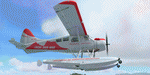
This folder contains a repaint for the Milviz DHC-2 Beaver, representing Beaver c/n 1544 which was built in 1964, and became VH-IDN with Aerial Agriculture. It later flew with several companies over the Great Barrier Reef, and became VH-AQU with Aquatic Airways in 1990. It became VH-YKY while flying with Tasmania Air Adventure in 2012. After liquidation of the company in 2015, the aircraft went to Fiji, where it is currently flying as DQ-REJ with Turtle Airways. Repaint by Jan Kees Blom, based in the Milviz paintkit.
| Filename: | De_Havilland_Canada_DHC2_Beaver_VHYKY.zip |
| License: | Freeware |
| Added: | 8th August 2018, 10:49:23 |
| Downloads: | 218 |
| Author: | Jan Kees Blom |
| Size: | 8.04 MB |
| Category: Flight Simulator X - Aircraft Repaints, Textures and Modifications | |
| De Havilland Canada DHC-2 Beaver (JZ-PAC) |
|
Images related to this file:
File Description:
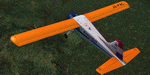
This folder contains a repaint for the Milviz DHC-2 Beaver, representing Beaver c/n 947 JZ-PAC of the NNGLM. On 14 July 1955, the company Nederlands Nieuw Guinea Luchtvaart Maatschappij (NNGLM) was established as a subsidiary of Dutch airline KLM, to provide air services within the Dutch territory of Netherlands New Guinea. This new airline, operating under the name of De Kroonduif, was based at Biak, and operated several routes throughout the territory with two de Havilland Canada Beavers. Later the fleet was also supplemented with Douglas DC-3 Dakotas and Twin Pioneers.
As Western New Guinea was being incorporated into Indonesian territory on 1 January 1963, the operations of De Kroonduif were absorbed by Indonesian airline Garuda, JZ-PAC becoming PK-GBB. Repaint by Jan Kees Blom based on the paintkit by Milviz.
| Filename: | De_Havilland_Canada_DHC2_Beaver_JZPAC.zip |
| License: | Freeware |
| Added: | 8th August 2018, 10:49:47 |
| Downloads: | 158 |
| Author: | Jan Kees Blom |
| Size: | 7.89 MB |
| Category: Flight Simulator 2004 - Scenery | |
| Clyde River CYCY & Cape Christian in Nunavut Canada |
|
Images related to this file:
File Description:
Clyde River is a village on the northeast coast of Baffin Island, 250 miles above the Arctic Circle and around 150 miles north of Cape Hooper. It is on the shore of Patricia Bay at the entrance to Cylde Inlet, a fjord which stretches over 60 miles inland. The population is around 880 folks, and it was named by the explorer John Ross in 1818. The airfield is just east of the village and the lighted runway is 3,501' of 100' wide gravel at 87' ASL, aligned 018 True 198 True; "True" as opposed to magnetic in the Northern Domestic Airspace. There are two aprons, one with the new terminal building and one with the old terminal and the garage. Five miles northeast of Clyde River is Cape Christian, where there is a gravel runway around 3,000' long and adjacent to the beach, built to serve what was started as a weather station and later became a LORAN navigation system station. The station is still there, though it was closed some time ago and is now the subject of decontamination work. The runway is usable, though only for light planes as it is a bit rough. First Air and Canadian North are the AI planes visting Clyde River.
| Filename: | Clyde_River_CYCY__Cape_Christian_in_Nunavut_Canada.zip |
| License: | Freeware |
| Added: | 14th July 2011, 20:26:14 |
| Downloads: | 454 |
| Author: | Roger Wensley |
| Size: | 3.33 MB |
| Category: Flight Simulator 2004 - Scenery | |
| Lac des Plages grass strip in Quebec Canada |
|
Images related to this file:
File Description:
Lac des Plages is in Quebec on the north shore of the lake (and village) of the same name, some 55 miles northeast of Ottawa. It is an old grass strip and next to a tourist trailer park ("caravan" to the English). The runway is almost north-south and 2,200 feet long, and I went there to see if it is still in use. It is in good condition but there was nobody to ask (in early April) if it is still used and nobody turned up see if a plane had landed. I doubt if it is used regularly as there are no "wear" marks that show up on a grass strip, and the flare pots (actually old wheel rims with charcoal in them?) beside the runway could have been lit three months ago or three years ago, there was no way to tell. The single hangar is obviously no longer in use as a hangar, and the lack of a fence between the trailers and the grass strip would be a danger to pilot and strolling pedestrian alike. However, the runway still exists and here it is and as in real life the northern end slopes unevenly up.
| Filename: | Lac_des_Plages_grass_strip_in_Quebec_Canada.zip |
| License: | Freeware, limited distribution |
| Added: | 10th May 2010, 16:03:42 |
| Downloads: | 283 |
| Author: | Roger Wensley |
| Size: | 1.33 MB |
| Category: Flight Simulator 2004 - Scenery | |
| Kimmirut CYLC on Baffin Island in Nunavut, Canada |
|
Images related to this file:
File Description:
Kimmirut is a village of some 400 folks at the southern end of the southwest-facing coast of Baffin Island, 75 miles southwest of Iqaluit. It is on the northern side of the Hudson Strait between Baffin Island and Quebec, opposite Kangiqsujuaq on the Quebec shore. The airfield is served by two flights per week, one on Monday and another on Friday, only half fueled to be able to use the 1,899' of gravel 75' wide runway. The terminal building is small and there is a garage building for airport maintenance vehicles (snow clearing). There are some nearby buildings that I have included. The village is "represented" (not "modeled") with approximately the right shape and road layout. Take enough fuel so that you can leave again, as fuel is no longer for sale here. The Cape Dyer bgls are to make a small correction, it is explained in the text. I will not be posting new sceneries in the future and this is the last one for Avsim; it completes Baffin Island.
| Filename: | Kimmirut_CYLC_on_Baffin_Island_in_Nunavut_Canada.zip |
| License: | Freeware, limited distribution |
| Added: | 25th July 2011, 17:36:57 |
| Downloads: | 534 |
| Author: | Roger Wensley |
| Size: | 2.53 MB |
| Category: Flight Simulator 2004 - Scenery | |
| Aklavik CYKD in the Northwest Territories, Canada Revised |
|
Images related to this file:
File Description:
This version of Aklavik replaces the previous version so delete all previous installation elements. There is also for Inuvik replacement AI, additional texture, and replacement scenery bgl; this presumes you have already installed my revised post of Inuvik. There is also for Tuktoyuktak additional textures, and replacement scenery bgl's; this presumes you have already installed my 2012 post of Tuktoyakyuk.
Aklavik is a town of 650 or so inhabitants 120 miles inside the Arctic Circle and on the West Channel of the Mackenzie River delta. It is 40 miles west of Inuvik. There are two airlines serving the town on a regular basis and one is Aklak Air, operated by Kenn Borek. Aklavik village has not been changed since my previous post, but the airfield now has the correct terminal building.
The Inuvik replacement AI involves flights to Aklavik and Tuktoyaktuk and the texture and replacement bgl's are for gates that I forgot to include before.
The Tuktoyaktuk scenery now has a barge carrying the prefabricated new terminal for Grise Fiord, plus other items for the installation work. Northern terminals are prefabricated and delivered either complete or in flat-pack form to reduce construction time on site to a minimum. There is a note explaining why the terminal building is on a barge instead of being installed at its destination!
| Filename: | Aklavik_CYKD_in_the_Northwest_Territories_Canada_R.zip |
| License: | Freeware |
| Added: | 14th May 2012, 17:20:39 |
| Downloads: | 537 |
| Author: | Roger Wensley |
| Size: | 8.6 MB |
| Category: Flight Simulator 2004 - Scenery | |
| Ontario Small Fields in Canada: #01 Leamington (CLM2) |
|
Images related to this file:
File Description:
This is the first of a series of small airfields in southern Ontario, Canada. It is Leamington CLM2, a field near a small town of the same name beside Lake Erie. The airfield has an asphalt runway of 3,820 feet, though with displaced thresholds at each end due to electric cable strung along the roads for an effective landing length of around 2,800. Right-hand circuits for runway 19 to avoid over-flying a nature reserve around a stretch of shallow water to the northeast. The intention is that downloaders will add further posts to the first, which will avoid unnecessary texture duplication (for instance for parked cars or planes) and avoid adding yet another small field to the FS9 scenery library. The second airfield will probably be Harrow CGL2, a grass field to the west of Leamington.
| Filename: | Ontario_Small_Fields_in_Canada_01_Leamington_CLM2.zip |
| License: | Freeware, limited distribution |
| Added: | 18th July 2015, 15:03:26 |
| Downloads: | 162 |
| Author: | Roger Wensley |
| Size: | 3.23 MB |
| Category: Flight Simulator 2004 - Scenery | |
| Ontario Small Fields in Canada: #02 Harrow CGL2 |
|
Images related to this file:
File Description:
This is the second in a series of small airfields in southern Ontario, Canada. It is Harrow CGL2, a field near a small town of the same name close to Lake Erie. The airfield has a grass runway of 3,000 feet, with short displaced thresholds (400 feet) at each end; the south due to the trees and the north due to a road and fence. The electric cable strung along this road (unlike Leamington, with it's warning visibility spheres) is buried for a short stretch the width of the runway, but avoid the poles. The intention is that downloaders will add further posts to the earlier ones, which will avoid unnecessary texture duplication (for instance for parked cars or planes) and avoid adding yet another small field to the FS9 scenery library. The third airfield will probably be Essex CNE9, a grass field to the west of Harrow.
| Filename: | Ontario_Small_Fields_in_Canada_02_Harrow_CGL2.zip |
| License: | Freeware, limited distribution |
| Added: | 19th July 2015, 19:44:00 |
| Downloads: | 182 |
| Author: | Roger Wensley |
| Size: | 1.54 MB |
© 2001-2026 AVSIM Online
All Rights Reserved
Privacy Policy |