
Where Flight Simulation Enthusiasts Gather from Around the World!
AVSIM Library - Search Results

| Category: Flight Simulator 2004 - Scenery | |
| Bluff Park Farm 71AK, Wasilla Creek Airpark 05AK, Memory Lake 5AK8, 3AK2, 05AK, 5AK5, 16AK, 34AK, 59AK, and AK65, all near Anchorage in Alaska, PART 2 Flattens |

|
Images related to this file:
File Description:
Bluff Park Farm 71AK, plus Wasilla Creek Airpark 05AK, plus Memory Lake 5AK8, plus 3AK2, 05AK, 5AK5, 16AK, 34AK, 59AK, and AK65, all near Anchorage in Alaska, US FLATTENS PART 2
This is a PART 2 repost from 100 years ago because only one down-loader informed me very very recently that three airfields in that area needed altitude adjustment, namely 5AK8, 05AK, and 71AK. If you have this problem put the three bgl's in the FS9/Scenery/World/Scenery folder. If you don't have this problem then ignore this and finish your beer.
| Filename: | Bluff_Park_Farm_71AK_Wasilla_Creek_Airpark_05AK_Me.zip |
| License: | Freeware, limited distribution |
| Added: | 29th November 2019, 22:41:51 |
| Downloads: | 112 |
| Author: | Roger Wensley |
| Size: | 4.2 KB |
| Category: Prepar3D V1-4 - AI Flight Plans | |
| SAS Scandinavian Airlines Summer 2023 |
|
Images related to this file:
File Description:

Welcome to the complete Summer 2023 flight plans for SAS, based on the week 23-29 April 2023. I have used real-world rotations with scheduled times of departure and arrival except for rotations affected by delays and some adjustments to make everything work in a one-week pattern.
I have included all charter flights, positioning flights and flights operated by Cityjet, Xfly, Jettime and SmartLynx. SAS now uses some alphanumeric callsigns, which we are not able to reproduce in P3D, so I have used commercial flight numbers throughout.
| Filename: | SAS_Scandinavian_Airlines_Summer_2023.zip |
| License: | Freeware |
| Added: | 3rd July 2023, 16:07:34 |
| Downloads: | 238 |
| Author: | Alexander Michael |
| Size: | 67.86 KB |
| Category: Flight Simulator 2004 - AFCAD Files | |
| Al Udeid AB, Qatar (OTBH) |
|
File Description:
Al Udeid AB in Qatar is the most technologically advanced military base in the world and boasts the longest runway in the Persian Gulf region. It was built at the cost of more than a billion dollars and has since replaced Prince Sultan AB as the US nerve center in the region. Al Udeid is home of the 379th Air Expeditionary Wing which hosts several squadrons of aircraft from the US, UK, and Australia. Created using satellite photos and various other photos. Includes some simple flightplans to add some activity to the base.
| Filename: | Al_Udeid_AB_Qatar_OTBH.zip |
| License: | Freeware, limited distribution |
| Added: | 20th December 2005, 15:56:24 |
| Downloads: | 2,029 |
| Author: | Matt Magner |
| Size: | 250.74 KB |
| Category: Flight Simulator 2004 - Aircraft Repaints, Textures and Modifications | |
| TDS Airbus A350-941 Alaska Airlines Dual Liveries(Fictional) |
|
Images related to this file:
File Description:
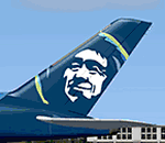
2004/P3D/(FSX with limitations) Alaska Airlines Dual Liveries, Alaska and Alaska One World(Fictional). Alaska Airlines is a major American airline headquartered in SeaTac, Washington, within the Seattle metropolitan area. It is the sixth largest airline in the United States when measured by fleet size, scheduled passengers carried, and the number of destinations served. Model Builder : Hiroshi Igami, FDE Designer : Nate Rosenstrauch, Master Painter : Carlos Eduardo Salas Franco PBR Texture : Ken Webber (Operation Infinity) - The Basekit "is required" and may be downloaded at: https://library.avsim.net/download.php?DLID=224270
| Filename: | TDS_Airbus_A350941_Alaska_Airlines_Dual_LiveriesFi.zip |
| License: | Freeware, limited distribution |
| Added: | 11th February 2022, 00:20:21 |
| Downloads: | 273 |
| Author: | Danny Cummings |
| Size: | 35.56 MB |
| Category: Civil Flight Simulators - Looking Glass Flight Unlimited 3 | |
| Visual GTL Editor |
|
Images related to this file:
File Description:

This is a standalone program that allows you to change the terrain textures of outer terrain megatiles by applying altitude based rule changes. This means that the Editor allows you to do what FU3 does through the RULES.TXT file but in visual form and on a per tile basis. The Editor converts and displays l0xxxx.gtl files and their corresponding l5xxxx.geo elevation files to 512x512 bitmaps. It also displays useful information when moving the mouse across the main display, i.e. Min Alt, Max Alt, Alt Range, Alt Index, Texture and so on. The Index value is an altitude range corresponding to the 64 colours used to create the elevation bitmap and is useful when specifying Min Alt and Max Alt values for rule changes. You can apply up to 8 rule changes at a time (just repeat until you get the desired results), either to the entire tile or to a subsection defined as X and Y co-ordinates. The Editor displays X-origin and Y-origin values within the tile as an aid to this. You can use this with the default 13 textures or with my extended 26 textures.
| Filename: | Visual_GTL_Editor.zip |
| License: | Freeware |
| Added: | 29th June 2011, 21:14:30 |
| Downloads: | 76 |
| Author: | Jonathan Stonehouse |
| Size: | 2.76 MB |
| Category: Flight Simulator 2004 - Scenery | |
| Durban Island CWFB FOX-E DEW line station in Nunavut, Canada |
|
Images related to this file:
File Description:
Durban Island is 40 miles north of Cape Dyer on the southeast corner of Baffin Island, and around 60 miles southeast of Qikiqtarjuaq (known as Broughton until recently). Sitting on the top of the island is FOX-E, an intermediate station that was part of the DEW line. There is no runway (and once you have seen the island you will know why) and the station and its (usually) five man crew were supported by helicopter flights from Cape Dyer. The main feature is a 300' high mast, topped by comms gear to link both to Broughton to the north and Cape Dyer to the south. There was only one really habitable building, 80' x 30' in round figures, and this contained the generators, technical spaces, sleeping areas, kitchen, mess, and showers etc. There were also what were known as Anderson shelters, originally put up to house the construction crew and used in the summer for any maintenance people who visited for short periods. There was also a garage for a snow cat and tanks for fuel. And a view.
This post also includes new bgls for Cape Dyer to provide the 300' tower there too.
| Filename: | Durban_Island_CWFB_FOXE_DEW_line_station_in_Nunavu.zip |
| License: | Freeware, limited distribution |
| Added: | 1st July 2011, 22:11:33 |
| Downloads: | 315 |
| Author: | Roger Wensley |
| Size: | 1.87 MB |
| Category: Flight Simulator 2004 - Scenery | |
| CYCQ - Chetwynd - British Columbia, Canada |
|
Images related to this file:
File Description:
The town of Chetwynd (population around 2,600) is on the east side of the Rocky Mountains, the first town to be encountered when descending from the Rockies on highway 97. Previously known as Little Prairie, the town name was changed in 1962. The main occupations of the town are linked to forestry, fossil fuels, and transportation; there are railway lines north to Fort St John, east to Dawson Creek, and south to Prince George. The airport is on the southern side of the town, with one runway aligned 05-23, asphalted in 1975 and just under 4,500 feet long. There are no scheduled services, although a new terminal building was constructed in 2008, and the helicopter operations by at least two companies (oil and gas and medical evacuation flights) are the primary operations from the field. These are included in the AI, incorporating helicopter modifications made by Holger Sandmann so that they function properly as AI at an airfield. As an aside, landing like a plane and using the runway and taxiways is in fact exactly what a helicopter does at a normal airfield in real life; everyone does the same thing so that guessing is unneccesary.
| Filename: | CYCQ__Chetwynd__British_Columbia_Canada.zip |
| License: | Freeware, limited distribution |
| Added: | 28th March 2016, 21:36:33 |
| Downloads: | 300 |
| Author: | Roger Wensley |
| Size: | 18.84 MB |
| Category: Prepar3D V1-4 - Aircraft Repaints, Textures and Modifications | |
| Pan Am L-049 Constellation |
|
Images related to this file:
File Description:

Pan American World Airways livery for the A2A COTS L049 Constellation. These textures will also work in FSX.
Pan American World Airways, known from its founding until 1950 as Pan American Airways[1] and commonly known as Pan Am, was the principal and largest international air carrier in the United States from 1927 until its collapse on December 4, 1991. Founded in 1927 as a scheduled air mail and passenger service operating between Key West, Florida, and Havana, Cuba, the airline became a major company credited with many innovations that shaped the international airline industry, including the widespread use of jet aircraft, jumbo jets, and computerized reservation systems. It was also a founding member of the International Air Transport Association (IATA), the global airline industry association.[3] Identified by its blue globe logo ("The Blue Meatball"), the use of the word "Clipper" in aircraft names and call signs, and the white pilot uniform caps, the airline was a cultural icon of the 20th century. In an era dominated by flag carriers that were wholly or majority government-owned, it was also the unofficial overseas flag carrier of the United States. During most of the jet era, Pan Am's flagship terminal was the Worldport located at John F. Kennedy International Airport in New York City.(Source: Wikipedia)
All logos and texts had to be recreated, since there was nothing usable on the net.
| Filename: | Pan_Am_L049_Constellation.zip |
| License: | Freeware, limited distribution |
| Added: | 6th January 2017, 08:29:29 |
| Downloads: | 1,175 |
| Author: | Eberhard Haberkorn / A2A |
| Size: | 65.23 MB |
| Category: Flight Simulator X - Scenery | |
| FSX Grand Canyon North Rim Simulation |
|
Images related to this file:
File Description:
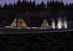
Welcome to the North Rim of the Grand Canyon!
This scenery is a mostly fictitious representation of what the North Rim might look like of it had been developed like the South rim. A new airport (KKPA, Kaibab Plateau Airport) is the centerpiece. It sits at 8,730 ft MSL so density altitude is a real issue. Runway 17/35 is 6,500ft long so biz jets can get in and out safely. A new resort sits atop the ridge to the east [Eagle's Nest]. There is a helipad for access. An NDB makes finding it easier [AZ95 220.9 kHz]. Or you can just follow the traffic on the access road that branches off from highway 67 just south of the airport. To the north I have added a gravel strip to Jacob Lake where 67 joins 89A. Runway 14/32 is 3000 ft long and sits at 7900 ft MSL. An NDB [AZ93 393 kHz] is included. At the south end of Highway 67 sits the North Rim Visitor Center. There is a helipad on the roof for those who like rotary wing challenges. The NDB is AZ94 at 423.4 kHz. The entire length of Highway 67 is represented with traffic going both ways. You will see
air traffic from KGCN at the South Rim and traffic between KKPA and Jacob Lake.
| Filename: | FSX_Grand_Canyon_North_Rim_Simulation.zip |
| License: | Freeware, limited distribution |
| Added: | 19th May 2021, 19:28:12 |
| Downloads: | 100 |
| Author: | Brett Delana |
| Size: | 16.26 MB |
| Category: Flight Simulator 2004 - Scenery | |
| Skydive Lake Elsinore Scenery |
|
File Description:
Located next to Lake Elsinore in California, is an airfield that brings excitement to many people’s day, every day. The name of this airfield is Skylark Field. It is home to many skydivers and glider pilots around the area. This scenery is based on the real world airfield, Skylark Field (CA89) by Lake Elsinore, CA.
| Filename: | Skydive_Lake_Elsinore_Scenery.zip |
| License: | Freeware |
| Added: | 4th August 2006, 21:26:05 |
| Downloads: | 894 |
| Author: | Kobbe Farwick |
| Size: | 2.24 MB |


© 2001-2026 AVSIM Online
All Rights Reserved
Privacy Policy |