
Where Flight Simulation Enthusiasts Gather from Around the World!
AVSIM Library - Search Results

| Category: Flight Simulator 2004 - Miscellaneous Files | |
| Sorted POI global cities and airports pack for FSDiscover! |

|
File Description:
README:
FSDiscover! Global Point of Interest pack.
Here is a poi pack of roughly 147 000 cities, 40 000 small airports,
1 177 seaplane bases, 4695 medium airports and 475 of the largest
airports.
Airports are split up in categories, small, medium, big, seaplane base.
Cities are split up into files of 10 000 cities each by size.
There are 15 files for cities.
The smallest cities are in xaa, xab, xac, xad, and so on.
The biggest cities are in xam, xan, until xao.
You should open the files in notepad to see for yourself which city
files to activate in FSDiscover! to balance clutter and detail.
This has been my main problem with the default populated places list;
there is no way to sort by population size
Compared to the default FSDiscover! populated places here are some
notes:
I have noticed that in the default FSDiscover! set for europe and many
other places, the coordinates are placed like on a "honeycomb" grid
which obviously is not very precise. In general, in terms of city map
precision, this pack should be better.
In the default pack, in an area I am familiar with, a city was placed on the other side of
a river compared to reality. In many other areas, you can clearly see
that the cities are not well-aligned with Ultimate Terrain europe or
even some places in UT USA. My theory is that either data was not super
precise for europe to begin with or that the dataset has been arranged
in the honeycomb grid fashion perhaps to reduce clutter or something.
Mostly though, the default populated places FSDiscover! file is very
useful for really small villages since these tend to be forgotten in
other datasets. The problems come when you want to filter out smaller
villages or airports. This is where this pack comes in handy.
Since no data is perfect, you can use this pack alone or in
combination with the FSDiscover! defaults. Personally, I put the same
files in both "Documents/FSDiscover Files" and
"Program Files/FSDiscover" so I can pick and choose a useful combo
from relevant sets inside the options.
Personally, I prefer the cities from this pack and the rest
(mountains, rivers etc.) from the default FSDiscover! pack.
INSTALLATION:
Just unzip the archived files into "C:\Users\YOURUSERNAME\Documents\FSDiscover Files"
or "C:\Program Files (x86)\FSDiscover!\geodata" or both!
I do not know if the geodata folder is completely overwritten some
times or not so keep that in mind. (probably safe, though)
AUTHOR:
fs9_2003 thanks to data made available by opendatasoft.com and ourairports.com
The source for cities:
https://public.opendatasoft.com/explore/dataset/geonames-all-cities-with-a-population-1000
The source for airports:
https://ourairports.com/data
| Filename: | Sorted_POI_global_cities_and_airports_pack_for_FSD.zip |
| License: | Freeware |
| Added: | 6th May 2024, 14:13:54 |
| Downloads: | 53 |
| Author: | Kim Husainov |
| Size: | 3.18 MB |
| Category: Prepar3D V1-4 - Scenery | |
| KILE, Killeen Texas airport |
|
Images related to this file:
File Description: Instructions: There are 3 folders in this package; effects, scenery and texture.
Create a subfolder under the C:\Program Files (x86)\Lockheed Martin\Prepar3D v3\Scenery folder and call this new folder KILE.
Place the scenery and texture folders (with their associated contents) under this newly created KILE subfolder.
Place only the contents (not the folder) of the effects folder in the P3D effects folder often located at C:\Program Files (x86)\Lockheed Martin\Prepar3D v3\Effects.
Now start up P3D.
On the menu at the top of the P3D screen click on World > Scenery Library > Add Area. This will bring up the Add Scenery Area dialog box. Click the Browse button and browse to find the newly created KILE folder. It should be located at C:\Program Files (x86)\Lockheed Martin\Prepar3D v3\Scenery. Once you select the KILE folder, click the OK button. This will place that folder in the P3D scenery library. You will notice that the library is organized by priority starting at 1. I have my KILE scenery set as #4 priority but I am not sure if it needs to be that high. I did notice during design that sometimes my ground texture at the airport would act strange and I found that by setting KILE to a higher priority, it fixed that. As a last step make sure the checkbox to enable the scenery is checked and click OK.
You should now have the new KILE scenery available to use.
This package covers KILE, Killeen Texas airport. It is a city owned public use airport located 3 miles east of Killeen Texas. It has one runway that is 5,495 x 100 feet.
Almost 100 custom objects are included in this package. They include:
All hangers and buildings on the airport grounds made from on site photos.
Several buildings surrounding the airport grounds.
All taxiway and runway signs.
All taxiway, runway and approach lighting.
ILS antenna, localizer, etc.
Fuel tanks and parking T's.
Night lighting where appropriate.
Currently I am using the default land class instead of photo real because I couldn't find any photo real that suited my needs.
I welcome your feedback good or bad. Currently this airport is only for P3D. I may create an FSX version if I have enough requests. I started learning to make 3d objects and airports last year and I am learning something new every day. I hope you enjoy!
I plan on improving the night lighting for the runway lights, runway end lights, taxiway lights, etc. to make them more visible from a distance at night. I also want to replace the stock P3D vehicles with my own design and a few other things to come in an updated version down the road.
| Filename: | KILE_Killeen_Texas_airport.zip |
| License: | Freeware |
| Added: | 11th May 2017, 19:54:19 |
| Downloads: | 492 |
| Author: | Shannan Landreth |
| Size: | 23.83 MB |
| Category: Flight Simulator X - Aircraft Repaints, Textures and Modifications | |
| Consolidated PBY-5A (C-FCRR) |
|
Images related to this file:
File Description:

This folder contains a repaint for the Aerosoft PBY Catalina for FSX. It is shown here as C-FCRR, with Air France colors. Built by Boeing of Canada at Vancouver, it became RCAF Canso 9767 on March 4, 1943, and was allocated to Squadron 162, coded S, at Reykjavik, Iceland. In 1944, piloted by Flying Officers Thomas Charles Cooke and Eric Walter Wiskin, 9767 sank the German U-boat U-342 off the coast of Iceland on April 17. The amphibian was removed from the military service on April 1, 1946. The same year it was sold to Canadian Pacific Airlines, registered CF-CRR and assigned fleet number 233 (later 933), it was operated until 1959, thereafter by Northland Airlines (1960-1968), Midwest Airlines (1969-1970), and Ilford Riverton until 1973. The registration was changed to C-FCRR when Avalon Aviation acquired it as a water bomber in 1977, listed as Tanker number 791.
In 1995 the aircraft was bought by Powell Eorp. Of Parry Sound, Ontario, subsequently it was owned by the Canadian Air Legend. The French pilot Franklin Devaux bought C-FCRR in 1995 and converted it to a flying television studio, it was based at Le Bourget, Paris, France. During 1996 C-FCRR was the star of monthly French television programme Operation Okavango, while in September 1998 it was the eye catcher of the three-week Champs-Elysees (Paris) static air show. The following October the aircraft started an 8,078 mls (13,000 km) trip to Chile via Dakar (Senegal) and Natal (Brazil) to commemorate early Air France South Atlantic mail service, returning to France in June 1999. On January 19, 2002 the aircraft was stored at Orly Airport, Paris, and has not flown since. Its Canadian registration was cancelled on October 7, 2005. At present it seems to be registered as N9767, and in airworthy condition again. Here's a youtube movie on this aircraft: http://www.youtube.com/watch?v=s6jyzV8Gawc. Repaint by Jan Kees Blom, based on the repaint kit by Aerosoft.
| Filename: | Consolidated_PBY5A_CFCRR.zip |
| License: | Freeware |
| Added: | 13th July 2018, 20:34:21 |
| Downloads: | 151 |
| Author: | Jan Kees Blom |
| Size: | 9.83 MB |
| Category: Flight Simulator X - Aircraft Repaints, Textures and Modifications | |
| Consolidated PBY Catalina C-FCRR |
|
Images related to this file:
File Description:

This folder contains a repaint for the Aerosoft PBY Catalina for FSX. It is shown here as C-FCRR, with Air France colors. Built by Boeing of Canada at Vancouver, it became RCAF Canso 9767 on March 4, 1943, and was allocated to Squadron 162, coded S, at Reykjavik, Iceland. In 1944, piloted by Flying Officers Thomas Charles Cooke and Eric Walter Wiskin, 9767 sank the German U-boat U-342 off the coast of Iceland on April 17. The amphibian was removed from the military service on April 1, 1946. The same year it was sold to Canadian Pacific Airlines, registered CF-CRR and assigned fleet number 233 (later 933), it was operated until 1959, thereafter by Northland Airlines (1960-1968), Midwest Airlines (1969-1970), and Ilford Riverton until 1973. The registration was changed to C-FCRR when Avalon Aviation acquired it as a water bomber in 1977, listed as Tanker number 791.
In 1995 the aircraft was bought by Powell Eorp. Of Parry Sound, Ontario, subsequently it was owned by the Canadian Air Legend. The French pilot Franklin Devaux bought C-FCRR in 1995 and converted it to a flying television studio, it was based at Le Bourget, Paris, France. During 1996 C-FCRR was the star of monthly French television programme Operation Okavango, while in September 1998 it was the eye catcher of the three-week Champs-Elysees (Paris) static air show. The following October the aircraft started an 8,078 mls (13,000 km) trip to Chile via Dakar (Senegal) and Natal (Brazil) to commemorate early Air France South Atlantic mail service, returning to France in June 1999. On January 19, 2002 the aircraft was stored at Orly Airport, Paris, and has not flown since. Its Canadian registration was cancelled on October 7, 2005. At present it seems to be registered as N9767, and in airworthy condition again. Here's a youtube movie on this aircraft: http://www.youtube.com/watch?v=s6jyzV8Gawc. Repaint by Jan Kees Blom, based on the repaint kit by Aerosoft.
| Filename: | Consolidated_PBY_Catalina_CFCRR.zip |
| License: | Freeware, limited distribution |
| Added: | 26th September 2010, 11:33:47 |
| Downloads: | 1,195 |
| Author: | Jan Kees Blom |
| Size: | 9.83 MB |
| Category: Flight Simulator X - Aircraft Repaints, Textures and Modifications | |
| Republic P-47D-20 365th FG (B4-W) "Mortician's Delight" |
|
Images related to this file:
File Description:
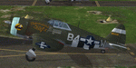
This folder contains a repaint for the A2A Wings of Power III P-47D Thunderbolt, representing P-47D-5-RE 42-8438 B4-W "Morticians Delight", one of the P-47's flown by Lt Neal Worley of the 387th FS/ 365th FG. Lt. Worley's first two P-47's were called 'Kansas Jack', referring to his Emporia, Kansas upbringing, but he did not feel like naming his third aircraft. His crew came up with 'Morticians Delight', and Worley himself painted the picture on the engine cowling. In 127 missions, he crashed 5 Thunderbolts. His coolness under pressure was immortilized on July 26th, 1944. A 20 mm shell hit his right wheel well during an attack on Sauveur Lendelin, jamming the wheel. He discovered that only the left wheel would lower, but would not retract, so bellying in was no longer an option. He circled for over an hour, burning fuel, and then landed on only the left gear, easing the fighter down. When the right wing dipped just enough, he hit the left brake, and the P-47 spun to a stop. His landing was captured on film, and used in the movie "Fighter Squadron". The aircraft was repaired, and flew missions the very next day, as a testament to the ruggedness of the Thunderbolt. Repaint by Jan Kees Blom, based on the paintkit by Martin Catney.
| Filename: | Republic_P47D20_365th_FG_B4W_Morticians_Delight.zip |
| License: | Freeware |
| Added: | 30th November 2019, 18:26:25 |
| Downloads: | 48 |
| Author: | Jan Kees Blom |
| Size: | 9.9 MB |
| Category: Prepar3D V1-4 - Aircraft Repaints, Textures and Modifications | |
| Jabiru J170 (ZU-OPS) |
|
Images related to this file:
File Description:
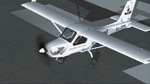
Branded Tail of the GRU Airwing Jabiru.
Game Reserves United GRU) is a grouping of both private and provincial reserves on the western boundary of the Kruger National Park that have come together as a united front, working collaboratively to stop rhino poaching. GRU is a coordinated effort to proactively combat rhino poaching across 25 private and provincial nature reserves (200 000ha). The project has been up and running since early 2013 but has thus far been lacking aerial support.
In a unique and generous gesture Jabiru S.A. and Jabiru Australia have jointly made available a brand new Jabiru J170 aircraft to launch the GRU-Jabiru Airwing. Len en Les Alford of Jabiru SA felt compelled to contribute towards the anti-rhino poaching campaign and chose GRU to manage the operational side for the aircraft that they are making available. It is also their wish that the aircraft provides an opportunity for professional pilots to gain flying time towards their higher qualifications. Five Hoedspruit pilots were chosen for the roster. Jaco Scheepers and Wynand Uys will collect the aircraft from the Jabiru Factory in George in middle September. The “Rhino-Jab†as the aircraft has become known, is generously fitted with communications and navigational equipment to facilitate the pilots in their task to support the ground forces of the various member reserves. Appropriately, its registration is ZU-OPS.
| Filename: | Jabiru_J170_ZUOPS.zip |
| License: | Freeware |
| Added: | 29th April 2018, 16:27:49 |
| Downloads: | 129 |
| Author: | Eberhard Haberkorn / IRIS Simulations |
| Size: | 18.44 MB |
| Category: X-Plane - Scenery | |
| EPGO - Goraszka 2007 for X-Plane 8 |
|
Images related to this file:
File Description:

EPGO GORASZKA 2007 SCENERY FOR X-PLANE 8
----- ABOUT THE AIRPORT -----
EPGO Goraszka airport is located 12nm (20km) south-east of Warsaw downtown and Warsaw Frederic Chopin International Airport. It was built in 1994 and belongs to General Aviation company, which offers aero-taxi flights, air transport and special flights (air photo, patrol) and airport services. The airport has a 800m-long runway and a lightened helipad, which can be used by helicopters up to 5700kg weight. General Aviation's fleet includes Antonov AN-2, PZL-104 Wilga 80, Bell 407 and 427. Since 1996 the International Air Picnic Goraszka is organized every year by "Polish Eagles" Foundation created on initiative of Zbigniew Niemczycki.
----- SCENERY FEATURES -----
This airstrip has never been included in any of X-plane series default airports list and this is the first, detailed scenery of EPGO. Main features of the scenery are:
-Ground photo texture for the surrounding area - perfect for VFR approaches (four seasons + night textures)
-Airport ground high resolution textures - feel the grass when taxiing (four seasons + night textures)
-Highly detailed 3D objects, all photo textured - we made over 300 photos to have them all realistically textured
-Detailed autogen for the whole area - almost every building and every tree
-Tower view - feel like an air traffic controller
| Filename: | EPGO__Goraszka_2007_for_XPlane_8.zip |
| License: | Freeware, limited distribution |
| Added: | 27th October 2015, 15:16:51 |
| Downloads: | 25 |
| Author: | Drzewiecki Design |
| Size: | 50.53 MB |
| Category: X-Plane - Scenery | |
| EPGO - Goraszka 2007 for X-Plane 9 |
|
Images related to this file:
File Description:

EPGO GORASZKA 2007 SCENERY FOR X-PLANE 9
----- ABOUT THE AIRPORT -----
EPGO Goraszka airport is located 12nm (20km) south-east of Warsaw downtown and Warsaw Frederic Chopin International Airport. It was built in 1994 and belongs to General Aviation company, which offers aero-taxi flights, air transport and special flights (air photo, patrol) and airport services. The airport has a 800m-long runway and a lightened helipad, which can be used by helicopters up to 5700kg weight. General Aviation's fleet includes Antonov AN-2, PZL-104 Wilga 80, Bell 407 and 427. Since 1996 the International Air Picnic Goraszka is organized every year by "Polish Eagles" Foundation created on initiative of Zbigniew Niemczycki.
----- SCENERY FEATURES -----
This airstrip has never been included in any of X-plane series default airports list and this is the first, detailed scenery of EPGO. Main features of the scenery are:
- Ground photo texture for the surrounding area - perfect for VFR approaches (four seasons + night textures)
- Airport ground high resolution textures - feel the grass when taxiing (four seasons + night textures)
- Highly detailed 3D objects, all photo textured - we made over 300 photos to have them all realistically textured
- Detailed autogen for the whole area - almost every building and every tree
- Tower view - feel like an air traffic controller
| Filename: | EPGO__Goraszka_2007_for_XPlane_9.zip |
| License: | Freeware, limited distribution |
| Added: | 27th October 2015, 15:18:36 |
| Downloads: | 49 |
| Author: | Drzewiecki Design |
| Size: | 44.65 MB |
| Category: Flight Simulator X - Scenery | |
| YEEB Eneabba, Western Australia strip and townsite |
|
File Description:
YEEB Eneabba strip and townsite
Sand mining town in heart of wildflower area Located 278 km north from Perth via the Brand Highway, Eneabba is basically a sand mining town surrounded by some of the most extensive and spectacular wild flower displays anywhere in Western Australia. The town itself is, to be fair, a real non-event with dreary modern housing (with more than a hint of construction town design), a small shopping centre and a service station all of which look as though they have sprung up in the last 20-30 years. The wealth of the area is based on the rutile sands which lie to the south of the town as well as farming, particularly cattle grazing. With an estimated 80 per cent of the world's known rutile supplies the town can boast that it has the biggest deposits of rutile in both Australia and the world. The major mining company in the area is Iluka Resources Ltd. Eneabba is basically a service town for the mines but some of the miners, realising that Eneabba is hardly a paradise, have opted for commuting and live on the coast at Leeman and drive to work preferring the beach to the dry inland.
REQUIRES blencowe_librarykit_309494.zip (Available HERE)
| Filename: | YEEB_Eneabba_Western_Australia_strip_and_townsite.zip |
| License: | Freeware |
| Added: | 25th February 2013, 23:48:24 |
| Downloads: | 255 |
| Author: | Alan Blencowe |
| Size: | 3.59 MB |
| Category: Flight Simulator 2004 - Scenery | |
| PASN St Paul Island in Alaska |
|
Images related to this file:
File Description:
This is St Paul Island airport, plus the town and the harbour which has featured alongside Dutch Harbor in the tv series Deadliest Catch.
St Paul is in the Pribilof group of five islands around 250 miles north of Dutch Harbour. The town has a population of less than 600, so a lot smaller than Dutch Harbour and with only one processing plant, Trident.
The Ai includes a PenAir flight, a Coast Guard C-130, and Coast Guard helicopters; sea AI includes a fishing boat and a Coast Guard cutter. The Coast Guard C-130 and helicopter flights are to Dutch Harbor, so both sceneries are required to make it work as it should. The airport has 6,500 feet of 150 feet wide asphalt with 1,000 feet of over-run at each end, aligned 36/18, lit, and with two aprons at the southern end. There is no hangerage except for Coast Guard helicopters. Runway 36 has at its northern end a hill.
In real life the runway slopes up to the north by over 60 feet, but in FS9 it doesn't; hence the change in airport elevation to 80 feet ASL to get the northern end at least partly out of a box canyon. There is fuel available and it is dispensed from a truck, there are no pumps.
| Filename: | PASN_St_Paul_Island_in_Alaska.zip |
| License: | Freeware, limited distribution |
| Added: | 12th August 2012, 17:39:02 |
| Downloads: | 1,100 |
| Author: | Roger Wensley, Sidney Schwartz |
| Size: | 4.06 MB |


© 2001-2026 AVSIM Online
All Rights Reserved
Privacy Policy |