
Where Flight Simulation Enthusiasts Gather from Around the World!
AVSIM Library - Search Results

| Category: Flight Simulator 2004 - Panels | |
| Generic Customized Advanced Panels |

|
File Description:
FS2004 Generic Advanced Customized Panels. Since this panel includes All XML gauges for 2-, 3- and 4 Jet engines aircrafts, Concorde and Warplains for 1 and 2 Engines, including landing panel. Special effects of the visor in the mainpanel of the Concorde. It can be used for any heavy jet. Also you have 3 choices, between the metal gray color panel (old Boeing) or the brown color of the FS2004 boeing default and the feeling to be in a Airbus (PFD of A380). All gauges are on the same place in the different engine version or airplane, no more memorizing the different panels. It has a full working overhead, TCAS radar, ATC control, customized FS2004 GPS, ACS-GPS, APU, FMC, HUD, Wiper and many custom xml gauges. Special attention is made on the Radio, Fuel, PFD, Clock, Taxi speed control, Wind speed, Bank rate, Auto mb-Hg, Push back,and Sim speed. A lot of information during take off, flight and landing. Many warnings included. Ideal panel for beginners and advanced simmers. Special Credit of gauges to Acsoft, Arne Bartels, Eric Mariano, Björn Karlsson, Tony d'Ambrosi, Nick Pike, etc. Panel design and gauges by Guy de Smet.
| Filename: | Generic_Customized_Advanced_Panels.zip |
| License: | Freeware |
| Added: | 16th January 2004, 23:00:39 |
| Downloads: | 16,068 |
| Author: | Guy De Smet |
| Size: | 10.3 MB |
| Category: Flight Simulator 2004 - Scenery | |
| Alaska North Slope 10; Kivalina KVL in Alaska |
|
Images related to this file:
File Description:
The town of Barrow is in the far north of Alaska, and these are coastal villages or radar installations to the west, south, and east of Barrow on the North Slope. There will be further additions. Kivalina is a small village (population around 350) midway in the 150 mile gap between Point Hope to the north and Kotzebue to the south. The village is on a spit of land that is growing smaller and smaller with every year of erosion and the rise of sea level. The runway is 3,500 feet of gravel aligned 12-30 to the north of the village on the same spit. It was expected that 2025 would see the end of both village and runway, and possibly also the natural harbour that is the reason for the village's location. The modified width of the spit shown here is halved from the original FS9, and erosion has continued, enough that a sea defence wall has now been built. The AI has a daily flight by an ERA Alaska Cessna 208B, and some GA; read the note about the 208 to be downloaded and/or properly installed.
| Filename: | Alaska_North_Slope_10_Kivalina_KVL_in_Alaska.zip |
| License: | Freeware, limited distribution |
| Added: | 27th July 2016, 21:12:15 |
| Downloads: | 243 |
| Author: | Roger Wensley |
| Size: | 2.87 MB |
| Category: Flight Simulator 2004 - Scenery | |
| Alaska North Slope 5 - Nuiqsut PAQT |
|
Images related to this file:
File Description:
The town of Barrow is in the far north of Alaska, and these are coastal villages or radar installations to the west, south, and now east of Barrow. There will be further additions. Nuiqsut is a mainly Inuit community on the west side of the Colville River, around 20 miles south of the coast, and with a slowly declining population of around 420 or so. The airfield is just south of the town and has a gravel runway 5,000 feet long and aligned 04-22 in FS9. The airfield is the only year-round contact route to the rest of the world, though there are plans for a permanent road. The AI includes daily passenger flights early and late in the day, cargo deliveries, and some GA. It seems that the only photos I had of the airport were either of the old building or were not of Nuiqsut at all. The only pic I have seen (recently, which is why I now have doubts) of the new building is insufficient to model it, so I am sticking with the old or maybe incorrect version.
| Filename: | Alaska_North_Slope_5__Nuiqsut_PAQT.zip |
| License: | Freeware, limited distribution |
| Added: | 21st June 2016, 21:45:32 |
| Downloads: | 245 |
| Author: | Roger Wensley |
| Size: | 4.37 MB |
| Category: Flight Simulator 2004 - Scenery | |
| Ivujivik CYIK in Hudson Bay, Quebec, Canada |
|
Images related to this file:
File Description:
Ivujivik is a village of 350 or so inhabitants at N62 25 W78 on the northeastern corner of Hudson Bay. The village does not feature in FS9 but is included in this scenery with approximately the right shape (the coast, even with UT, is not exactly right) so just think of it as a hand-made auto-generated village which gives the airfield a reason. The runway is 3,500 feet of gravel 100 feet wide, which should be enough. I also added the roads, deleted the stock airfield background and added a new background, plus of course there is the scenery file and the AFCAD and AI. You may note that the terminal has the elevation written on the sign as 126', while on the winter photo it is written on the older & bigger sign as 130'. I thought this is because satellite radar has fixed the elevations of all airfields more accurately than before, as Rockcliffe too has gone from 192' to 188'; the alternative explanation is that global warming has raised sea level by 4'. Wow! That's a thought. I presume the new sign was made smaller as a cost saving.
| Filename: | Ivujivik_CYIK_in_Hudson_Bay_Quebec_Canada.zip |
| License: | Freeware, limited distribution |
| Added: | 31st October 2010, 07:41:20 |
| Downloads: | 458 |
| Author: | Roger Wensley |
| Size: | 2.07 MB |
| Category: Flight Simulator 2004 - Scenery | |
| Alps LOD10 Topo Mesh - Switzerland and France |
|
Images related to this file:
File Description:
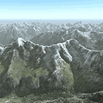
Yet another terrain mesh package of the European Alps? Well, this one is different in that it is NOT primarily based on the Shuttle Radar (SRTM) data with their incomplete coverage of prominent peaks and ridges. Instead, most of the source data for this project were developed over many months by Jonathan de Ferranti using detailed topographic maps. While Jonathan's work is unrelated to flight simulation he kindly gave me permission to compile his data for use in FS. The result is a wonderful improvement in detail and accuracy over any existing SRTM- or DTED-based mesh file, freeware or commercial (a link to an extensive set of screenshot comparisons is included in the read-me file).
I've compiled the source data at LOD10 (38-m) grid resolution because the coverage area is smaller than most existing mesh files. Thus, anyone can use these files without having to first uninstall their current mesh set. Also included are LOD9 and LO8 buffer mesh files. Note: if you own Switzerland Professional with its high-resolution terrain mesh then you don't need this package, at least not the Switzerland files!
| Filename: | Alps_LOD10_Topo_Mesh__Switzerland_and_France.zip |
| License: | Freeware, limited distribution |
| Added: | 30th May 2010, 09:51:03 |
| Downloads: | 58,993 |
| Author: | Holger Sandmann, Jonathan de Ferranti |
| Size: | 50.03 MB |
| Category: Flight Simulator X - Aircraft Repaints, Textures and Modifications | |
| Supermarine Spitfire Mk.IX BS273 High Altitude Flight |
|
Images related to this file:
File Description:
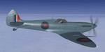
This folder contains a repaint for the Supermarine Spitfire Mk.IX by Real Air. It shows Spitfire IXc BS273, which was one of the Spitfires modified for high altitude interceptions, based at Northolt, 1942, and regularly flown by F/O Prince Emmanuel Galitzine. The prince was a Russian immigrant, a great grandson of Tsar Paul 1. After the Russian revolution, his family fled Russia, ending up in England. He wanted to fly, and when the Russian attacked Finland, he decided to join the Finnish Air Force. However, on hearing his mother was killed in the London blitz, he returned to the uK (via the US and Canada) and joined the RAF, becoming a Spitfire pilot with the Special Service Flight in Northolt. On 12 september 1942, he intercepted a JU-86 above Southampton at 41.000ft and attacked it. The battle went up to 43.000 ft, and was the highest recorded air battle of WWII. His spitfire only had two cannons, and one of them was frozen solid, giving a very unbalanced flight while shooting, combined with excessive vapor trails of his ammunition. It is believed he managed to hit the german aircraft, but in the end it got away safely. However, since the Germans now knew they could be intercepted, they launched no more high altitude attacks on the UK. Repaint by Jan Kees Blom, based on the paintkit by RealAir.
| Filename: | Supermarine_Spitfire_MkIX_BS273_High_Altitude_Flig.zip |
| License: | Freeware |
| Added: | 11th July 2018, 16:57:24 |
| Downloads: | 96 |
| Author: | Jan Kees Blom |
| Size: | 2.65 MB |
| Category: Flight Simulator X - Utilities | |
| FlyLive |
|
Images related to this file:
File Description:

FlyLive is a fully free and fully featured* flight simulation streaming suite.
Looking to beef up your FSX/P3D livestream for zero charge? You're at the right place! FlyLive is dedicated to satisfying even the most serious flight simulator streamers. The features are packed together in a sophisticated yet simple and user friendly interface - making it surprisingly easy to set up, with the help of the documentation.
The purpose of FlyLive is to inject flight data from your simulator into your livestream, so your audience don’t have to look at the tiny numbers on the flight instruments to know what’s going on. It is designed specifically for streamers who want to “up their game†in Flight Simulation streaming, but don’t have the knowledge to code something.
Perquisites
FlyLive relies on FSUIPC to extract data from the Simulator. You MUST have FSUIPC installed (free or registered) on your computer to use this software. FSUIPC can be downloaded from http://www.schiratti.com/dowson.html
You must have a broadcaster/recorder that can read from text files constantly. OBS Studio is an excellent, open source free broadcasting suite which FlyLive supports. OBS can be downloaded from https://www.obsproject.com
A *legal* working copy of any FSX version or P3D (except v1) with FSUPC must be installed on your computer.
*compared to similar programs
| Filename: | FlyLive.zip |
| License: | Freeware |
| Added: | 19th May 2017, 16:40:58 |
| Downloads: | 370 |
| Author: | Mark Ng |
| Size: | 100.24 KB |
| Category: Flight Simulator X - Utilities | |
| NumberPad Control Move Aircraft Utility |
|
File Description:
NpCmoveAircraft is a Lua script in the Numberpad Control family of FSX scripts that can be used to move an aircraft to a new position. Each step includes prompts for the required input and format. User inputs include the DISTANCE to move (NMs), the DIRECTION to move (degrees magnetic), the desired aircraft ALTITUDE (ft), the desired aircraft HEADING (degrees magnetic), and the desired aircraft IAS (Kts) along with the LANDING GEAR POSITION -- up (u), down (d) or fixed (f). Or for any of the five inputs the user can simply enter a carriage return (Enter key) to signify NO CHANGE for that particular entry.
Prior to the move the aircraft can be on the ground or in the air. So, for example, NpCmoveAircraft can be used to simply turn an a/c around, to move it to the other end of a runway, to re-position it for another approach after landing, to jump ahead in cruise, to catch up to another a/c, etc. NpCmoveAircraft works with default FSX aircraft and many add-on aircraft that adhere to the standard FSUIPC offsets.
A registered copy of FSUIPC is required to execute the NpCmoveAircraft Lua script. Simply copy the script to the Modules folder of FSX and assign a ‘hot key’, button or switch to activate the script.
Al Klayton
[email protected]
| Filename: | NumberPad_Control_Move_Aircraft_Utility.zip |
| License: | Freeware |
| Added: | 21st February 2017, 21:30:01 |
| Downloads: | 147 |
| Author: | Al Klayton |
| Size: | 3.92 KB |
| Category: Orbiter - Spaceships | |
| Project Mercury Addon Enhancement Pack |
|
File Description:
An enhancement package for the Project Mercury addon for Orbiter created by Rob Conley at the Medville Space Center http://home.alltel.net/estar/orbiter.html This enhancement pack contains updates to the REDSTONE, ATLAS rockets and the MERCURY Spacecraft. The REDSTONE texture was hand crafted in MS Paint (believe it or not) using archived pictures of both Freedom-7 and Liberty Bell 7 pre launch pictures as guides. It is now historically accurate, and cleaned up quite a bit. The ATLAS now sports a realistic corrigated booster section (with the texture taken right from a picture of Gordo Coopers pre-launch Atlas) and the upper section now has the frosty look that occured with the Atlas when it was loaded with LOX and fuel, and some historically accurate markings were included. The improvements to the MERCURY CAPSULE are numerous. It sports a real window (texture taken from a close up shot of Friendship-7), more darker exterior color that is more accurate, crisper detail, improved antenna housing and capsule top. Please note that there are TWO versions of the capsule exterior texture included. One called CAPMAIN.DDS sports a realistic name printed on the exterior, not assiciated with any real mission (America 7), and the other texture, CAPMAIN-NOLOGO.DDS, has no logo imprinted. Refer to the README file for instructions on how to change this to the non-logo capsule.
| Filename: | Project_Mercury_Addon_Enhancement_Pack.zip |
| License: | Freeware |
| Added: | 30th November 2003, 23:52:52 |
| Downloads: | 2,752 |
| Author: | Jim Williams |
| Size: | 131.67 KB |
| Category: Flight Simulator 2004 - Scenery | |
| Tongass Remote Airfield (RATR) - for "Tongass Fjords" (FS9) |
|
Images related to this file:
File Description:
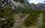
"Tongass Remote Airfield" (RATR) Alaskan scenery (Fictitious)
Tongass Remote Airfield is for Flight Simulator 2004 and for the "Tongass Fjords" (FS9) addon by Holger Sandmann & Bill Womack . You must have "Tongass Fjords" (FS9) for this to work.
Field history and description:
In the early days this area was well known to prospectors and hunters. A small mine was established and later abandoned. Around the late 40���¢��������s a crew was contracted to clear a small landing area to gain easier access for hunters and campers. Due to the extreme remoteness of this area that clearing took several years. The last phase was the approach, clearing by hand a descending glide slope through just the tops of the tall trees. There is now just enough room for a very experienced pilot to get in and out of this field. The airfield is 26 miles north of Petersburg Alaska (PAPG). This is a tricky narrow approach with a left hand dogleg and then an immediate right hand dogleg turn just before the final approach. Not much time to set up your approach, also, it's a very short runway. For experienced pilots only, and make sure that your life insurance is up to date. See enclosed Maps and info. Good luck.
| Filename: | Tongass_Remote_Airfield_RATR__for_Tongass_Fjords_F.zip |
| License: | Freeware, limited distribution |
| Added: | 11th February 2010, 00:49:22 |
| Downloads: | 623 |
| Author: | Jay Langham |
| Size: | 3.51 MB |


© 2001-2026 AVSIM Online
All Rights Reserved
Privacy Policy |